Want more images or videos?
Request additional images or videos from the seller
1 of 6
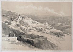
Island of Philae, Egypt. Early 19th century engraving, 18201820
1820
$650List Price
About the Item
- Creation Year:1820
- Dimensions:Height: 20.87 in (53 cm)Width: 27.96 in (71 cm)
- Medium:
- After:FC Cecile (French)
- Period:
- Condition:Toning to the edges of the sheet. Discolouration and small breaks in the paper on the right edge of sheet. Waterstain to top right corner of the sheet. Bottom left hand corner tip of sheet missing. A couple of very faint creases to top right corner.
- Gallery Location:Melbourne, AU
- Reference Number:Seller: CL34401stDibs: LU1244215550622
About the Seller
5.0
Platinum Seller
Premium sellers with a 4.7+ rating and 24-hour response times
Established in 2005
1stDibs seller since 2019
610 sales on 1stDibs
Authenticity Guarantee
In the unlikely event there’s an issue with an item’s authenticity, contact us within 1 year for a full refund. DetailsMoney-Back Guarantee
If your item is not as described, is damaged in transit, or does not arrive, contact us within 7 days for a full refund. Details24-Hour Cancellation
You have a 24-hour grace period in which to reconsider your purchase, with no questions asked.Vetted Professional Sellers
Our world-class sellers must adhere to strict standards for service and quality, maintaining the integrity of our listings.Price-Match Guarantee
If you find that a seller listed the same item for a lower price elsewhere, we’ll match it.Trusted Global Delivery
Our best-in-class carrier network provides specialized shipping options worldwide, including custom delivery.You May Also Like
1776 Navigational chart/map of the Delaware bay and river including Philadelphia
Located in Philadelphia, PA
JOSHUA FISHER
(AMERICAN, EIGHTEENTH CENTURY)
A Chart of Delaware Bay and River, 1776
Printed for John Bennet and Robert Sayer, London
Engraving on pape...
Category
1770s Realist Landscape Prints
Materials
Paper, Engraving

$5,000
H 19.5 in W 28.25 in
L'Isle de France: A Hand-colored 17th Century Map by De Wit
By Frederick de Wit
Located in Alamo, CA
This colorful and detailed 17th century hand-colored copperplate map by Frederick De Wit was published in Amsterdam between 1666 and 1760. The map depicts the Île-de-France, which is one of the ancient provinces of France. Paris is located in the center of the map, with Versailles to the southwest The map extends from Rouen in the west to Reims in the east. The area around Paris, the Véxin Français, was the original domain of the king of France. Other areas were ruled by French feudal lords. For example, the Véxin Normand area was the domain of the Duke of Normandy...
Category
Early 18th Century Old Masters More Prints
Materials
Engraving

$1,175
H 28.25 in W 31.25 in D 0.75 in
View of Seravalle, Italy: A 16th Century Hand-colored Map by Braun & Hogenberg
By Franz Hogenberg
Located in Alamo, CA
This is an original 16th century copperplate originally hand-colored engraved map of View of Seravalle, Italy entitled "Seravallum Celeberrimum Marchiae Tarvisiniae in Agro Foro Juliensi Opp. - Seravalli, quam vides, Spectator, iconem, operi huic nostro suis sumptib. . . ." by Georg Braun & Franz Hogenberg, from their famous city atlas "Civitates Orbis Terrarum", published in Augsberg, Germany in 1575.
The map depicts a view of Seravalle, now Vittorio Veneto, in San Marino, Italy, north of Venice, in a topographically accurate bird's-eye view from the south. A water-filled moat is seen to the south of the city walls and farmland to the east. Two men are depicted standing on a hill in the lower right in conversation next to grain sacks and a grazing horse, while a younger man behind them to the right herds a mule carrying presumably pigs. A very colorful and ornate title cartouche is in the upper center and coat-of-arms are in the right and left upper corners. Serravalle lies in an idyllic setting in the foothills and surrounded by orchards. St Mary's Cathedral with its tall bell tower is prominent in the center of the town. The marketplace and town hall with a bell tower in the square are depicted. Houses and shops are around the main square. Serravalle's importance as an agricultural centre is emphasized by the figures in the foreground. In 1337 Serravalle was conquered by the Republic of Venice. In 1866 the town was united with neighbouring Ceneda to form the town of Vittorio Veneto.
The following is an English translation of an excerpt from the French description of the city on the back of the map: "Serravalle, a market town renowned for cloth, wine and grain, is in such a beautiful situation that the number of its inhabitants, attracted by the loveliness of the place, has grown so much at times that the wall encircling it has had to be enlarged for the third time. The city with the surrounding town once belonged to the Church in Ceneda as an imperial fief. It subsequently became the seat of the Da Camino family (a princely house that at that time was one of the five most noble in all Italy). Now the city is under the sway of the Venetians but is prudently governed by them. For they send only one city councillor with instructions to ensure that justice prevails and to collect duties. In all else, power lies in the hands of the noble families."
This is a translation of the Latin in the title cartouche on the front: "The picture of the town of Serravalle, which you see, viewer, has been contributed to our work entirely at his own expense by Minutius, son of Hieronymus Minutius, a noble gentleman and one renowned for the far-reaching competence of his jurisdiction. We saw him sojourning in Cologne, where he was on business for Gregory XIII; while our good wishes accompany him, we should also like to accompany him on his way with this remembrance, even though it might be against his will, so that even those who have not seen him may learn of his excellence. However, those who do not yet know him will also see his excellence if God the Almighthy does not summon erring souls too soon back to the eternal seat of the Blessed."
References: Van der Krogt 4, 4728, State 1; Taschen, Braun and Hogenberg, p.331; Fauser, #14960
This striking hand-colored city view is printed on laid, chain-linked paper with wide margins. The sheet measures 16" high by 21" wide. There is a central vertical fold as issued and French text on the verso, with Latin on the front. There is some discoloration in the upper and right margins which may represent some watercolor paint from the time of the original hand-coloring of the map. There is a small hole to the right of the upper portion of the vertical fold, which is only visible when held up to light and an area of reinforcement on the verso of the lower vertical fold. The map is otherwise in very good to excellent condition.
Braun and Hogenberg's 'The Civitates Orbis Terrarum' was the second atlas of maps ever published and the first atlas of cities and towns of the world. It is one of the most important books published in the 16th century. Most of the maps in the atlas were engraved by Franz Hogenberg and the text, with its descriptions of the history and additional factual information of the cities, was written by a team of writers and edited by Georg Braun. The work contained 546 bird-eye views and map views of cities and towns from all over the world. It gave graphic representation of the main features of the illustrated cities and towns, including the buildings and streets. Although the ordinary buildings are stylized, the principal buildings are reproduced from actual drawings created on location. The principal landmarks and streets can still be recognized today. In addition, the maps often include the heraldic arms of the city, the nature of the surrounding countryside, the important rivers, streams and harbors, even depicting stone bridges, wooden pontoons, flat-bottomed ferries, ships and working boats, wharves and jetties, as well as land-based activities, including horsemen, pedestrians, wagons, coaches, and palanquins. Small vignettes are often included which illustrate the trade, occupations and habits of the local inhabitants, such as agriculture, paper-making and textiles, as well as local forms of punishment, such as gibbets, wheels, floggings etc. Large figures dressed in their local costume are often presented out of proportion in the foreground. The aim of the authors was to give as much information as possible in a pleasing visual form. They succeeded in creating maps that were both informative and decorative works of art. The atlas is a wonderful glimpse of life in medieval Europe.
Georg Braun (1541-1622) was German Catholic...
Category
16th Century Old Masters Landscape Prints
Materials
Engraving

China: An Original 18th Century Hand-colored Map by E. Bowen
Located in Alamo, CA
This is an original 18th century hand-colored map entitled "A New & Accurate Map of China, Drawn from Surveys made by the Jesuit Missionaries, by order of the Emperor. The whole bein...
Category
Mid-18th Century Old Masters Landscape Prints
Materials
Engraving

$1,075
H 15.75 in W 19.75 in
Persia & Afghanistan: A Framed Hand-colored 17th Century Map by John Cary
By John Cary
Located in Alamo, CA
This colorful and detailed early 18th century copperplate map by John Cary entitled "A New Map of Persia from the Latest Authorities" was published in London in 1801. It depicts Persia, the region of modern day Afghanistan, the Caspian Sea, the Sea of Aral, the Persian Gulf...
Category
Early 19th Century Old Masters More Prints
Materials
Engraving

$1,175
H 23.5 in W 25.75 in D 1 in
Cartusia Bruxellensis Monastery in Brussels: A 17th C. Hand-colored Engraving
By Lucas Vorsterman the Younger
Located in Alamo, CA
This is a 17th century hand-colored copperplate engraving entitled "Cartusia Bruxellensis" by Lucas Vorsterman, the Younger, after a drawing by Jacob van Werden or Jacques van Weerden, published in 1659 in Antonius Sanderus' book 'Chorographia sacra Brabantiae sive celebrium aliquot in ea provincia ecclesiarum et coenobiorum descriptio . . . Brussel' (A sacred chorography of Brabant, or a description of several famous churches and convents in that province). It also appeared in other publications by Sanderus. In the 17th century, Brussels was within the Duchy of Brabant.
This engraving depicts a bird's-eye view of the Scheut Carthusian Monastery in Brussels. Scheut is a district of Anderlecht, a municipality of Brussels, Belgium. The monastery housed monks, who took a vow of silence, in 20 rooms. There is a central courtyard with trees and shrubs. Monks are depicted strolling along its pathways. The cells for the friars are in the middle the cloister. There are people along the streets in the foreground and to the right of the large, imposing monastery. Some are on horseback, others are walking. In the lower right, what appears to be a dog pulls a small cart containing barrels, possibly of beer or wine. Districts and neighborhoods are labelled in the background, including Scheut, Anderlecht and Ransfort. A very ornate cartouche in the lower left contains Latin and the artist's attribution. Another decorative cartouche in the upper central area contains the title.
This beautifully hand-colored and detailed engraving is printed on laid, chain-linked paper with wide, full margins. The sheet measures 17.25" high and 21.25" wide. It has Latin text on the verso. It has a central vertical fold, as issued, which is reinforced on the verso. Two small spots in the lower margin may actually represent drops of watercolor paint used to color the engraving. It is otherwise in very good condition.
Antonius Sanderus (1586-1664) was a Flemish Catholic cleric and historian. He was born "Antoon Sanders", but Latinized his name like many writers and scholars of his time. He was the author of several books, including 'Chorographia Sacra Brabantiae', which was illustrated with this engraving.
Lucas Vorsterman the Younger (1624-between 1666 & 1676) was a Flemish Baroque engraver and draughtsman. He produced engravings after the work of contemporary painters and for books by Antwerp publishers.
Jacob van Werden or Jacques van Weerden (active 1643-1669), was a Flemish draughtsman, cartographer, military engineer and archer who was active in the Habsburg Netherlands. His drawings were used as designs for prints executed by various printmakers. He worked on maps, topographical views, historical scenes, portraits and book illustrations. He had a career as a military engineer and a member of the guard of the Spanish King. He advised on various military engineering projects and was an engineer of the Spanish army...
Category
Mid-17th Century Old Masters Landscape Prints
Materials
Engraving

The Fighting Temeraire: A Framed 19th C. Engraving After J. M. W. Turner
By J.M.W. Turner
Located in Alamo, CA
This beautiful 19th century framed engraving "The Fighting Temeraire" by James Tibbetts Willmore is based on an original painting by the renowned British artist J.M.W. Turner. It was published by James S. Virtue & Co. in London between 1859-1875. It depicts the once mighty British warship the HMS Temeraire being towed away down the river Thames by a much smaller steamboat to a ship-breaking yard to be broken up for scrap. The Temeraire was first launched in 1798 and represented the pinnacle of British ship-building. 180-feet long, constructed of English oak and armed with 98 guns, she was one of the largest warships of the period. The Temeraire became a symbol of British pride and military power that endured throughout the 19th century. The man-of-war served during the French Revolutionary and Napoleonic Wars and was among the last serving ships to have been at the Battle of Trafalgar in 1805. It became one of the many older ships put out of service in the 1830s and 1840s. The once mighty and feared ship symbolizes a once magnificent, but now obsolete, technology. Turner seems to lament her inglorious final journey, being towed by a less magnificent, but modern steam powered tugboat.
The Turner painting was created in 1838 and is now held in the National Gallery in London. Willmore's engraving, created in 1859, captures the dramatic scene with great detail and skill. The image has become an iconic representation of the decline of Britain's naval power and the transition from sail to steam in the 19th century. The sunset in the background is symbolic of the sun going down on British naval power and tradition. The painting conveys profound and diverse themes that are central to the human experience: those of mortality and change, technology and progress, heroism and brutality. The painting demonstrates Turner’s skill as an artist. His ability to produce scenes of great beauty that are dramatic, but are also symbolic, stimulating both thoughtful analysis, as well as emotion. Turner's painting was voted by the British public in a 2005 BBC radio sponsored survey to be the British people's favorite painting of all time. In 2020 it was included on a new British banknote...
Category
Mid-19th Century Romantic Landscape Prints
Materials
Engraving
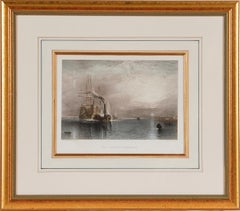
$675
H 18 in W 20.5 in D 1 in
Mediterranean and Adriatic Seas: Original 18th Century Hand-colored Map by Bowen
Located in Alamo, CA
This is an original 18th century hand-colored map entitled "An Accurate Chart of The Mediterranean and Adriatic Sea's; with the Archipelago & Part of the Black Sea. Exhibiting all th...
Category
Mid-18th Century Old Masters Landscape Prints
Materials
Engraving

$1,275
H 15.88 in W 23.75 in
View of Emden, Germany: A 16th Century Hand-colored Map by Braun & Hogenberg
By Franz Hogenberg
Located in Alamo, CA
This is a 16th century original hand-colored copperplate engraved map of a bird's-eye View of Embden, Germany entitled " Emuda, vulgo Embden vrbs Frisia orientalis primaria" by Georg Braun & Franz Hogenberg, in volume II of their famous city atlas "Civitates Orbis Terrarum", published in Cologne, Germany in 1575.
This is a beautifully colored and detailed map of Emden, a seaport in northwestern Germany, along the Ems River and perhaps portions of over Dollart Bay, near the border with the Netherland. The map depicts a bird's-eye view of the city from the southwest, as well as a view of the harbor and an extensive system of canals. Numerous ships of various sizes, as well as two rowboats containing numerous occupants are seen in the main waterway in the foreground and additional boats line two canals in the center of the city. Two men and two women are shown on a hill in the foreground on the right, dressed in the 16th century style of nobility. Two ornate crests are included in each corner. A title strap-work cartouche is in the upper center with the title in Latin. The crest on the right including Engelke up de Muer (The Little Angel on the Wall) was granted by Emperor Maximilian I in 1495.
This is an English translation of an excerpt of Braun's description of Embden: "In Emden, the capital of East Frisia, rich merchants live in very fine houses. The city has a broad and well-situated harbour, which in my opinion is unique in Holland. Frisia and the whole of the Netherlands, for the ships can anchor here right under the city walls. They have also extended the harbour as far as the New Town, so that up to 400 ships can now find shelter here when the sea is rough."
The emphasis on the harbor and waterways within the city highlights the importance of Emden's place as a seaport at this time. Embden developed from a Dutch/Flemish trading settlement in the 7th-8th centuries into a city as late as late 14th century. In 1494 it was granted staple rights, and in 1536 the harbour was extended. In the mid-16th century Emden's port was thought to have the most ships in Europe. Its population then was about 5,000, rising to 15,000 by the end of the 16th century. The Ems River flowed directly under the city walls, but its course was changed in the 17th century by the construction of a canal. Emden has canals within its city limits, a typical feature of Dutch towns, which also enabled the extension of the harbor. In 1744 Emden was annexed by Prussia and is now part of Germany. It was captured by French forces in 1757 during the Seven Years' War, but recaptured by Anglo-German forces in 1758. During the Napoleonic French era, Emden and the surrounding lands of East Frisia were part of the short-lived Kingdom of Holland.
References:Van der Krogt 4, 1230, State 2; Taschen, Braun and Hogenberg...
Category
16th Century Old Masters Landscape Prints
Materials
Engraving

$1,175
H 15.63 in W 21.25 in
View of Meissen, Germany: A 16th Century Hand-colored Map by Braun & Hogenberg
By Franz Hogenberg
Located in Alamo, CA
This is a 16th century original hand-colored copperplate engraved map of View of View of Meissen, Germany entitled "Misena Hermun Duvorum Urbs" by Georg Braun & Franz Hogenberg, from their famous city atlas "Civitates Orbis Terrarum", published in Cologne, Germany in 1575.
The map depicts a side view and bird's-eye view, looking across the Elbe River (labelled Albis Fluvius on the map; White River in Latin) from the northeast. In the foreground are three women in conversation on a hill above the city, along with a man and a woman in conversation by a road, all dressed in contemporary costumes of the upper class. A coat-of-arms is present in each upper corner. A great castle sits atop a hill in the background on the left. Meissen grew up around Albrechtsburg castle, built by Emperor Henry I around AD 929, and was granted a municipal charter at the end of the 12th century. From 1471 onwards, the castle complex was reconstructed as the residence of the Saxon electors on the northeast corner of the Domberg (Cathedral Hill). Meissen cathedral is a Gothic hall church begun c. 1270; in 1413 a bolt of lightning destroyed its west towers, which were replaced only in the 20th century. Meissen lies to the northwest of Dresden, Germany in Saxony. Meissen is famous for its Meissen porcelain and the Albrechtsburg castle
The following is an English translation of an excerpt from Braun's description of the city: "This city is surrounded by very many rivers, to the east flows the Elbe, to the south the Triebisch, to the west are the mountains, to the north the Meisse, after which the city is said to be named. The city is well-situated in its surroundings, the navigable rivers, the mountains and the healthy air. Around the city there is a good land to grow grain, fertile vineyards on the hillsides and without doubt the mountains are not without ore, for one mile away, up the Elbe, is Scharfenberg, where silver and lead ore are mined.."
References: Van der Krogt 4, 2684; Taschen, Braun and Hogenberg...
Category
16th Century Old Masters Landscape Prints
Materials
Engraving

$975
H 15.75 in W 21.25 in
More From This Seller
View AllPlan of the Park, Garden and Plantations of Goodwood, 18th century engraving
By Colen Campbell
Located in Melbourne, Victoria
Plan of the Park, Garden and Plantations of Goodwood in Sussex the Seat of his Grace the Duke of Richmond and Lenox &c
Copper-line engraving with later hand-colouring by Hendrik Hul...
Category
18th Century English School Landscape Prints
Materials
Engraving
Les Bergers Romains, landscape with Roman ruins, 18th century engraving
Located in Melbourne, Victoria
Les Bergers Romains
Copper-line engraving by Jean Jacques Leveau (1729-1786) after Pierre Mettay (1728-1759). C1755.
Proof, before lettering. Laid, watermarked paper.
A landscap...
Category
18th Century French School Landscape Prints
Materials
Engraving
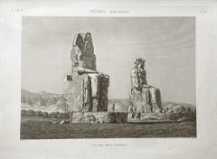
Colossi of Memnon, Thebes, Egypt. Early 19th century engraving, 1820
Located in Melbourne, Victoria
'Vue des Deux Colosses. Thebes, Memnonium'
Elephant folio engraving, by Baltard after Dutetre, from 'Description de l'Egypte', published after Napoleon's expedition to colonize Egyp...
Category
Early 19th Century Other Art Style Landscape Prints
Materials
Engraving
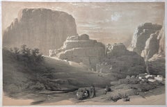
The Acropolis, Lower End of the Valley, Petra. David Roberts lithograph, 1849.
By David Roberts
Located in Melbourne, Victoria
'The Acropolis, Lower End of the Valley, Petra', tinted lithograph by Louis Haghe (1806-1885) after David Roberts RA.
David Roberts (1796-1864) traveled throughout Egypt and the Hol...
Category
Mid-19th Century Victorian Landscape Prints
Materials
Lithograph
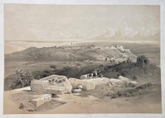
Gaza, Palestine, Holy Land. David Roberts lithograph, 1843.
By David Roberts
Located in Melbourne, Victoria
'Gaza', tinted lithograph by Louis Haghe (1806-1885) after David Roberts RA.
David Roberts (1796-1864) traveled throughout Egypt and the Holy Land in the late 1830s producing waterc...
Category
Mid-19th Century Victorian Landscape Prints
Materials
Lithograph
Convent of the Terra Santa, Nazareth. David Roberts Holy Land lithograph, 1844.
By David Roberts
Located in Melbourne, Victoria
'Convent of the Terra Santa, Nazareth', tinted lithograph by Louis Haghe (1806-1885) after David Roberts RA.
David Roberts (1796-1864) traveled throughout Egypt and the Holy Land in...
Category
Mid-19th Century Victorian Landscape Prints
Materials
Lithograph