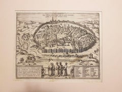
Items Similar to Danzig, Antique Map from "Civitates Orbis Terrarum" - 1572-1617
Want more images or videos?
Request additional images or videos from the seller
1 of 5
Franz HogenbergDanzig, Antique Map from "Civitates Orbis Terrarum" - 1572-16171572-1617
1572-1617
$473.14
£357.30
€400
CA$661.71
A$723.78
CHF 379.82
MX$8,656.07
NOK 4,793.36
SEK 4,471.63
DKK 3,047.01
About the Item
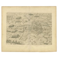
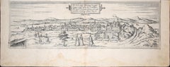
Braun G., Hogenberg F., Dantziat, from the collection Civitates Orbis Terrarum, Cologne, T. Graminaeus, 1572-1617.
Image dimensions: cm 32.8 x 47.9; dimensions: cm 42 x 55.3; passepartout dimensions: cm 50 x 64.7.
Wonderful B/W etching representing a view of the Polish city of Danzig, with an interesting caption in Latin, in a cartouche, on the lower left. Title is on plate in a cartouche on the upper center. Good conditions with a usual medial fold; lightly brown paper and some foxings on the margins.
The Civitates Orbis Terrarum (Atlas of the Cities of the World) was the second oldest printed atlas in the history of world cartography and the first atlas totally dedicated to topographical views. The first volume of this collection was published in Cologne in 1572; the following in 1575, 1581, 1588, and 1598. The sixth and final volume appeared in 1617, just before the extensive devastation wreaked by the Thirty Years’ War.
This artwork is shipped from Italy. Under existing legislation, any artwork in Italy created over 70 years ago by an artist who has died requires a licence for export regardless of the work’s market price. The shipping may require additional handling days to require the licence according to the final destination of the artwork.
- Creator:Franz Hogenberg (1540 - 1590, Flemish)
- Creation Year:1572-1617
- Dimensions:Height: 16.54 in (42 cm)Width: 21.78 in (55.3 cm)Depth: 0.04 in (1 mm)
- Medium:
- Period:
- Condition:Insurance may be requested by customers as additional service, contact us for more information.
- Gallery Location:Roma, IT
- Reference Number:Seller: M-947731stDibs: LU65033858641

Franz Hogenberg
Braun and Hogenberg's 'The Civitates Orbis Terrarum' was the second atlas of maps ever published and the first atlas of cities and towns of the world. It is one of the most important books published in the 16th century. Most of the maps in the atlas were engraved by Franz Hogenberg and the text, with its descriptions of the history and additional factual information of the cities, was written by a team of writers and edited by Georg Braun. The work contained 546 bird-eye views and map views of cities and towns from all over the world. It gave graphic representation of the main features of the illustrated cities and towns, including the buildings and streets. Although the ordinary buildings are stylized, the principal buildings are reproduced from actual drawings created on location. The principal landmarks and streets can still be recognized today. In addition, the maps often include the heraldic arms of the city, the nature of the surrounding countryside, the important rivers, streams and harbors, even depicting stone bridges, wooden pontoons, flat-bottomed ferries, ships and working boats, wharves and jetties, as well as land-based activities, including horsemen, pedestrians, wagons, coaches, and palanquins. Small vignettes are often included which illustrate the trade, occupations and habits of the local inhabitants, such as agriculture, paper-making and textiles, as well as local forms of punishment, such as gibbets, wheels, floggings etc. Large figures dressed in their local costume are often presented out of proportion in the foreground. The aim of the authors was to give as much information as possible in a pleasing visual form. They succeeded in creating maps that were both informative and decorative works of art. The atlas is a wonderful glimpse of life in medieval Europe. Georg Braun (1541-1622) was German Catholic cleric who was born and who died in Cologne, Germany. He was the principal editor of 'The Civitates Orbis Terrarum', acquiring the tables, hiring the artists, and composing the texts. Abraham Ortelius, whose Theatrum Orbis Terrarum of 1570 was the first atlas of maps ever published, assisted Braun in his compilation of the details and maps for the atlas. The Civitates was intended as a companion for the Ortellius' Theatrum, as suggested by the similarity in the titles. Braun was the only survivor of the original team to live to see the publication of last volume (VI) in 1617. Franz Hogenberg (1535-1590) was a Flemish and German painter, engraver, and mapmaker. He was born in Mechelen (also known as Malines) in Flanders, the son of an engraver. After being expelled from Antwerp by the Duke of Alva, he moved to London and then eventually to Cologne, Germany, where he met Georg Braun and Abraham Ortellius. He engraved most of the plates for Ortelius's Theatrum and the majority of those in the Civitates. Many believe that he was responsible for originating the Civitates project.
About the Seller
4.9
Platinum Seller
Premium sellers with a 4.7+ rating and 24-hour response times
1stDibs seller since 2017
7,827 sales on 1stDibs
Typical response time: 1 hour
- ShippingRetrieving quote...Shipping from: Roma, Italy
- Return Policy
More From This Seller
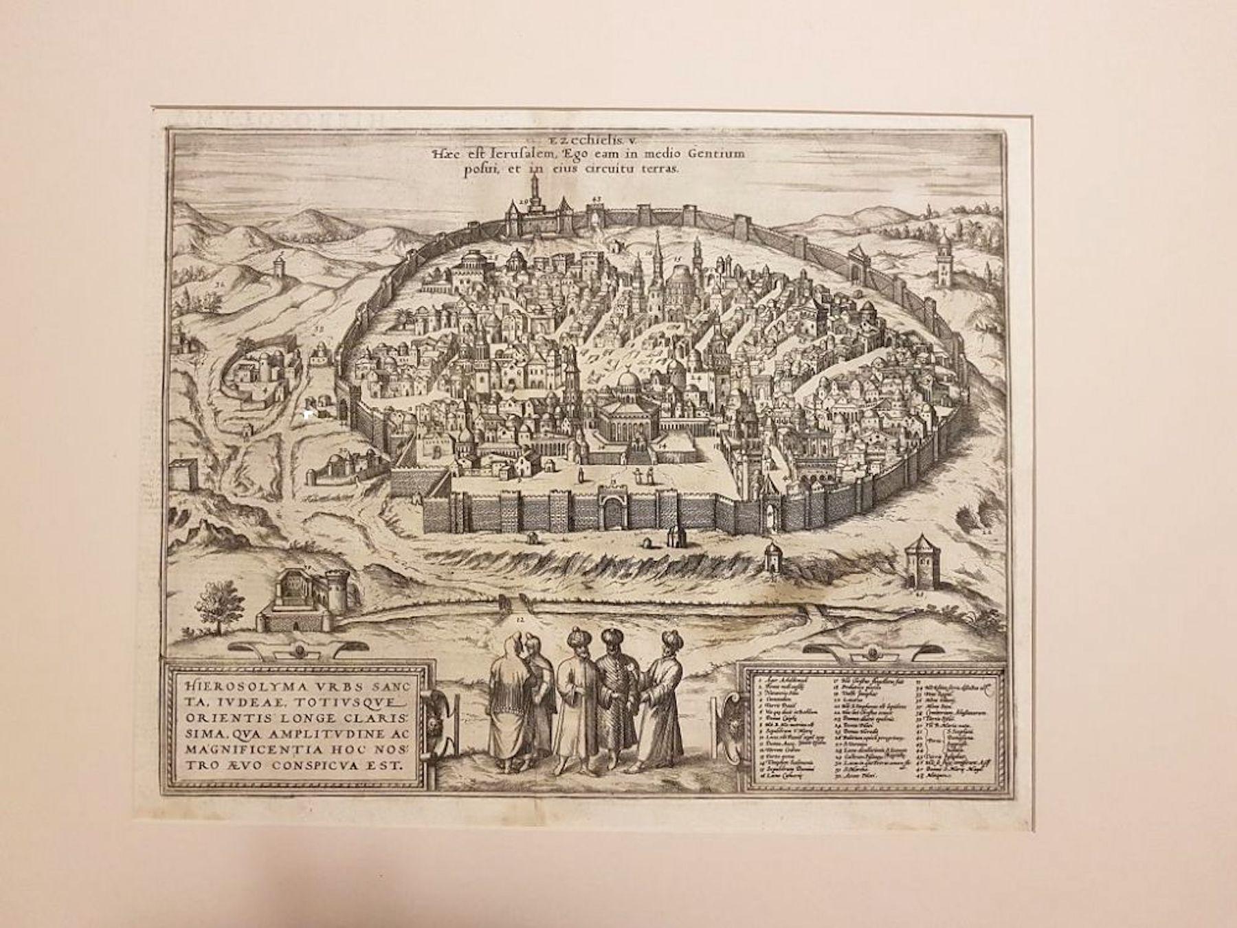
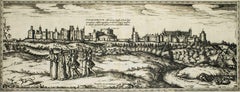
View AllJerusalem, Antique Map from "Civitates Orbis Terrarum" - 1572-1617
By Franz Hogenberg
Located in Roma, IT
Braun G., Hogenberg F., Jerusalem, from the collection Civitates Orbis Terrarum, Cologne, T. Graminaeus, 1572-1617.
Image dimensions: cm 32.8 x 41; dimensions: cm 41 x 54; Passepart...
Category
16th Century Landscape Prints
Materials
Etching
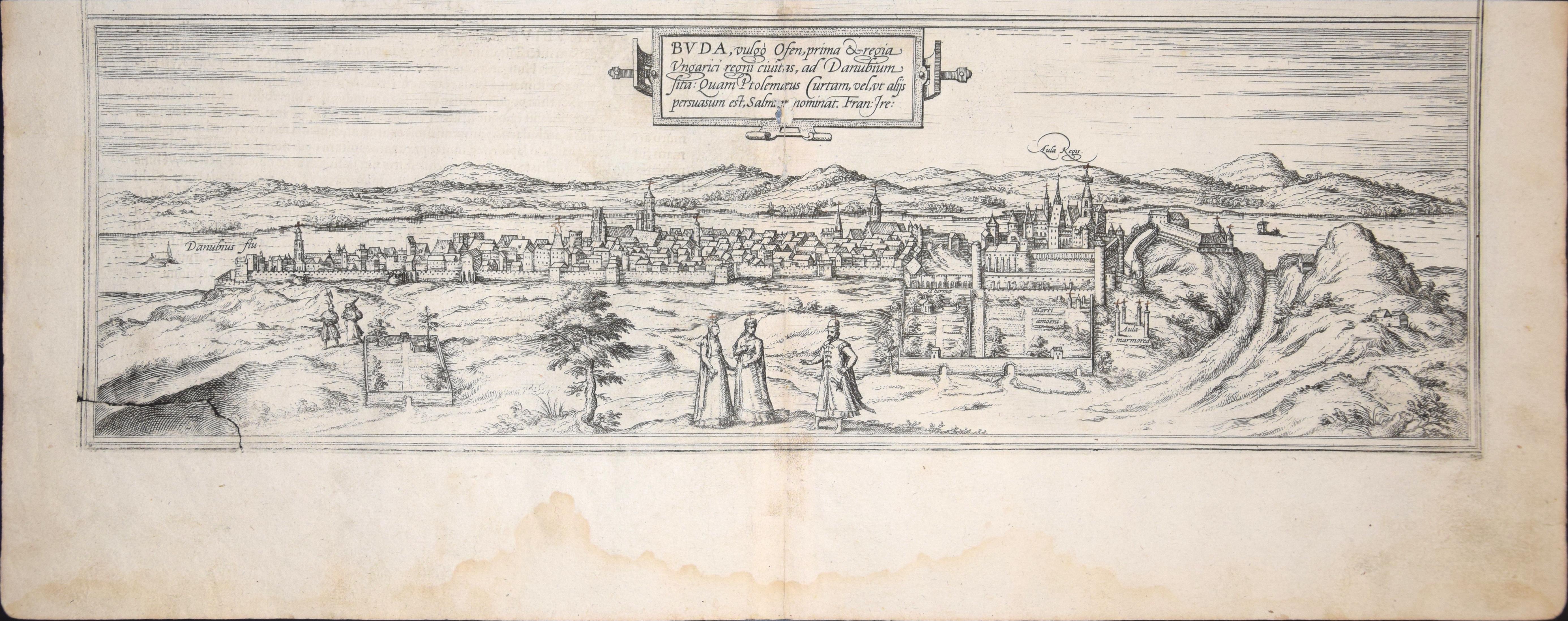
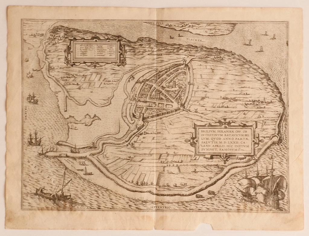
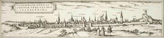
Buda, Antique Map from "Civitates Orbis Terrarum" - 1572-1617
By Franz Hogenberg
Located in Roma, IT
Braun G., Hogenberg F., Buda, from the collection Civitates Orbis Terrarum, Cologne, T. Graminaeus, 1572-1617.
Very fine B/W aquatint showing a view of Buda, an actual part of Budap...
Category
16th Century Landscape Prints
Materials
Etching
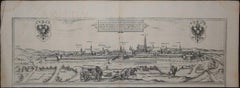
Oxford, Map from "Civitates Orbis Terrarum" - by F. Hogenberg - 1575
By Franz Hogenberg
Located in Roma, IT
Braun G., Hogenberg F., Oxonium or Oxford, from the collection Civitates Orbis Terrarum, Cologne, T. Graminaeus, 1572-1617.
Very fine and interestig B/W aquatint showing a view of O...
Category
16th Century Figurative Prints
Materials
Etching, Aquatint
Map of the Netherlands - Etching by G. Braun and F. Hogenberg -Late 16th Century
By Franz Hogenberg
Located in Roma, IT
Map of the Netherlands is an original etching realized by George Braun and Franz Hogenberg, as part of the "Civitates Orbis Terrarum".
The “Civitates Orbis Terrarum” (Atlas of Citi...
Category
16th Century Figurative Prints
Materials
Etching

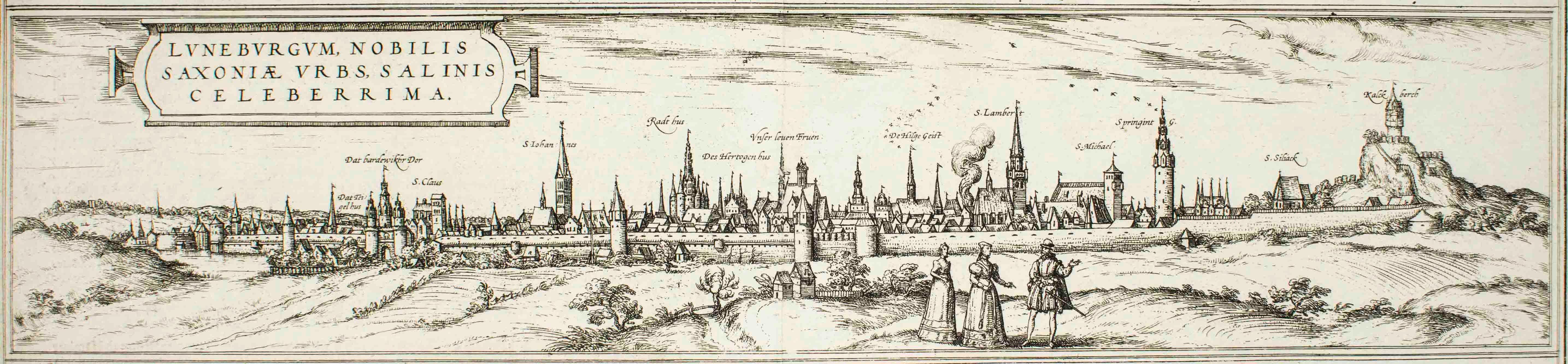
Luneburg, Map from "Civitates Orbis Terrarum" - by F.Hogenberg - 1575
By Franz Hogenberg
Located in Roma, IT
"Luneburg", from the collection "Civitates Orbis Terrarum", Cologne, T. Graminaeus, 1575.
The “Civitates Orbis Terrarum” (Atlas of Cities of the World) was the second oldest print...
Category
16th Century Figurative Prints
Materials
Etching, Aquatint
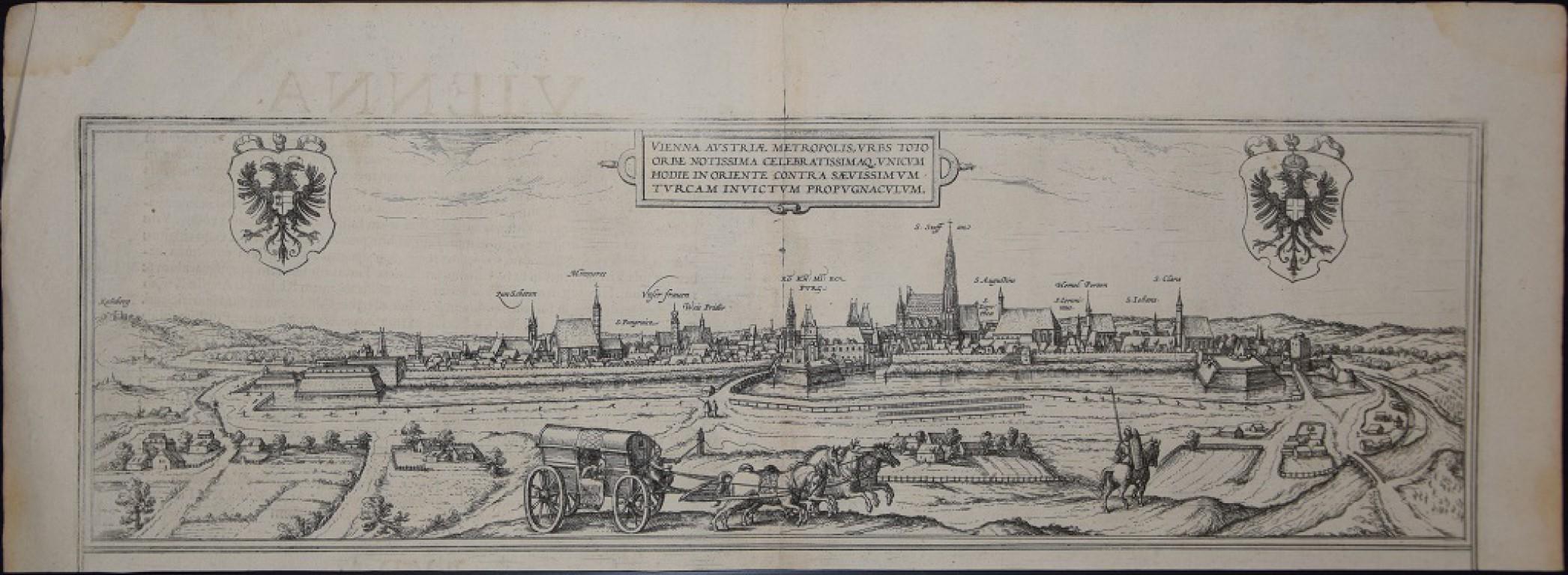
Vienna, Antique Map from "Civitates Orbis Terrarum" - Etching - Old Master
By Franz Hogenberg
Located in Roma, IT
Braun G., Hogenberg F., "Vienna", from the collection "Civitates Orbis Terrarum", Cologne, T. Graminaeus, 1572-1617. Image Dim: cm 15 x 47, Dim: cm 20 x 53.
Wonderful B/W Aquatint r...
Category
Early 17th Century Old Masters Figurative Prints
Materials
Etching, Aquatint
You May Also Like
Rare Antique Map of Leeuwarden, Friesland, The Netherlands, by P. Bast, 1603
By P. Bast
Located in Langweer, NL
Very rare plan of Leeuwarden, Friesland, The Netherlands. With several cartouches and coat of arms. With a legend and compass rose at bottom right. Made by 'Pieter Bast' after the su...
Category
Antique Early 17th Century Maps
Materials
Paper

$3,459 Sale Price
35% Off
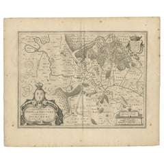
Antique Map of the Region of Sedan and Doncheri by Janssonius, 1657
By Johannes Janssonius
Located in Langweer, NL
Antique map of France titled 'La Souveraineté de Sedan et de Raucourt, et la prevosté de Doncheri'. Lovely map centered on Sedan and Doncheri and the Meuze River from Charleville and...
Category
Antique Mid-17th Century Maps
Materials
Paper
Limburg Cityscape 1580: Historical Copper Engraving by Braun and Hogenberg
Located in Langweer, NL
Title: Limburgum Oppidum Galliae Belgicae, vulgo Lympurch, gallicè, Lembor Dr.
Type: Print (Copper Engraving)
Circa 1580
Technique: Colored Copper Engraving
Medium: Handmade Paper
S...
Category
Antique 16th Century German Maps
Materials
Paper

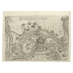
Antique Map of St. Andries 'Heerewaarden' by Orlers, 1615
Located in Langweer, NL
Antique map titled 'Prata Inundata'. This map depicts the area between the Maas and Waal river (The Netherlands) during the siege of St. Andries and Voorne under command of prince Ma...
Category
Antique 17th Century Maps
Materials
Paper
$169 Sale Price
20% Off
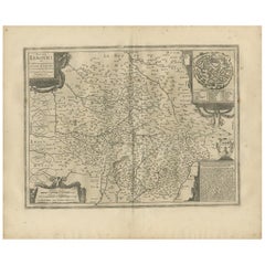
Antique Map of the Region of Limoge by Janssonius, '1657'
By Johannes Janssonius
Located in Langweer, NL
Antique map 'Totius Lemovici et consinium provinciaru quantum ad dioecesin Lemovicensen spectant'. Decorative map of the province of Limoge based on the important map of Antoin-Jean ...
Category
Antique Mid-17th Century Maps
Materials
Paper
Antique Map of the City of Oldenzaal by Orlers, 1615
Located in Langweer, NL
Antique map depicting the Siege of Oldenzaal, the Netherlands. The Siege of Oldenzaal was a short siege that took place during the Eighty Years' War and the Anglo–Spanish War by a Du...
Category
Antique 17th Century Maps
Materials
Paper