Items Similar to Rugen Island, Germany: An Early 17th Century Map by Mercator and Hondius
Want more images or videos?
Request additional images or videos from the seller
1 of 13
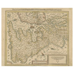
Gerard MercatorRugen Island, Germany: An Early 17th Century Map by Mercator and Hondius1623
1623
$540
$67520% Off
£411.08
£513.8420% Off
€469.95
€587.4320% Off
CA$759.79
CA$949.7320% Off
A$831.08
A$1,038.8520% Off
CHF 437.59
CHF 546.9820% Off
MX$9,922.28
MX$12,402.8520% Off
NOK 5,577.12
NOK 6,971.3920% Off
SEK 5,101.73
SEK 6,377.1620% Off
DKK 3,510.01
DKK 4,387.5220% Off
About the Item
This is an early 17th century map entitled "Nova Famigerabilis Insulae Ac Ducatus Rugiae Desciptio" (Map of Rugen Island, Germany) by Gerard Mercator and Henricus and Joducus Hondius, published in Amsterdam in 1623 in 'Atlas sive cosmographicae meditationes de fabrica mundi et Fabricati Figura' (Atlas or cosmographical meditations on the structure of the world and the Fabricated Figure), which was the first time the word" atlas" was used to describe a collection of maps published in book form. His engraved title-page showed King Atlas measuring the world with a pair of calipers. King Atlas was a mythical ruler of Mauritania, a mathematician and philosopher who supposedly made the first celestial globe. The term atlas has become the standard not only for a collection of maps, but also anatomical prints and other genres.
map of Rügen with Hiddensee by Eilhard Lübben. Shows the coast of the Baltic Sea from Peenemunde and Stralsund to Barhöft and the island of Rügen with many details. The coastline of Rügen largely corresponds to today's characteristics. The map is decorated with two galleons, several sea monsters, two large compass roses, one mileage scale with dividers and a cartouche with a large coat of arms. The left and right sides are flanked with 15 small coat of arms each. From the Mercator-Hondius Atlas published in 1623. Latin text on verso.
This map is focussed on Rügen Island (Latin: Rugia, Ruegen), Germany's largest island. It is located in the Baltic Sea, off the Pomeranian coast of northern Germany and is part of the state of Mecklenburg-Western Pomerania. In the Middle Ages it was ruled by Denmark. It later became a Duchy and then Province of Pomerania and in the 19th century, part of Germany.
This detailed and quite decorative map contains two striking compass roses, two detailed sailing ships, three sea monsters, a bird, as well as a massive coat-of-arms and a smaller one in the upper map on the right. There are thirty smaller coat-of-arms along both side borders (fifteen along each side border), representing the island's leading families. There is jagged line to the right of the title cartouche in the right lower corner that resulted from a crack in the copper plate, which presumably occurred shortly after production of the plate, or even before, as it seen on virtually all surviving examples of the map.
This highly detailed and striking map is printed on thick, laid, chain-linked paper with wide margins. The sheet measures 18.38" wide and 21.75" high. There is Latin text on the verso. The map has a central fold, as issued. There is faint discoloration and an occasional small spot in the margins and a small chip at the lower edge of the sheet. There is some offset of outlines from the opposite side of the map resulting from having been folded in an atlas for almost 400 years. The map is otherwise in excellent condition.
Gerard Mercator (1512-1594) is one of the greatest cartographers of all time. His friend, Abraham Ortelius, referred to Mercator as being the “contemporary Ptolemy”. He was born in Flanders and moved to Duisburg in the Netherlands, where he lived and worked for the rest of his life. In addition to producing important maps and globes, he invented a projection on maps that presented all parallels and meridians at right angles to each other, with the distance between the parallels extending towards the poles, allowing accurate latitude and longitude calculation and navigational routes to be drawn using straight lines. This was an important technological advance for navigation at sea, as this allowed seafarers to plot their course without having to adjust their course based on frequent compass readings. These lines became known as Mercator's projections when used by subsequent cartographers, including current map makers. As mentioned above, he is also the first to use the term “atlas”, to describe a collection of maps published in one bound book.
Jodocus Hondius (1563-1612) was a prominent globe maker and map engraver from Ghent (Flanders). After spending some time in London, he established his business in Amsterdam in 1593. Hondius bought the plates of Gerard Mercator in 1604 and added around 40 of his own maps in an atlas that he first published in 1606, preserving Mercator's name. After his death in 1612 in Amsterdam, the business was continued by his sons Jodocus II and Henricus.
- Creator:Gerard Mercator (1512 - 1594, Flemish, German)
- Creation Year:1623
- Dimensions:Height: 18.38 in (46.69 cm)Width: 21.75 in (55.25 cm)
- Medium:
- Movement & Style:
- Period:Early 17th Century
- Framing:Framing Options Available
- Condition:
- Gallery Location:Alamo, CA
- Reference Number:Seller: # 48621stDibs: LU1173211366952
Gerard Mercator
Gerard Mercator (1512-1594) was one of the most famous cartographers of the 16th century and, in fact, of all time. Mercator was known for his strict adherence to scientific methods of the day. He was responsible for advancing the technology of map making. For example his method of representing land masses in a cylindrical projection with north up and south down, first described in 1569, became the standard map projection for navigation. It is still referred to as The Mercator projection.
About the Seller
5.0
Platinum Seller
Premium sellers with a 4.7+ rating and 24-hour response times
Established in 2011
1stDibs seller since 2019
299 sales on 1stDibs
Typical response time: 1 hour
- ShippingRetrieving quote...Shipping from: Alamo, CA
- Return Policy
More From This Seller
View AllSoutheastern England: A 17th Century Hand-Colored Map by Mercator and Hondius
By Gerard Mercator
Located in Alamo, CA
A 17th century copperplate hand-colored map entitled "The Sixt Table of England" by Gerard Mercator and Jodocus Hondius, published in Amsterdam in 1635 in 'Cosmographicall Descriptio...
Category
1630s Landscape Prints
Materials
Engraving
Northern Scotland: 17th Century Hand-colored Map by Mercator
By Gerard Mercator
Located in Alamo, CA
This is a framed hand-colored 17th century map of Northern Scotland by Gerard Mercator entitled "Scotiae pars Septentrionalis", published in Amsterdam in 1636. It is a highly detailed map of the northern part of Scotland, with the northwest Highlands and the cities Inverness and Aberdeen, as well as the Orkney Islands and the Hebrides. There is a decorative title cartouche in the upper left corner.
The map is presented in an antiqued brown wood...
Category
Mid-17th Century Other Art Style Landscape Prints
Materials
Engraving

$940 Sale Price
20% Off
West Africa: A 17th Century Hand-Colored Map by Mercator/Hondius
By Gerard Mercator
Located in Alamo, CA
A 17th century hand-colored map entitled "Guineae Nova Descriptio" by Gerard Mercator and Jodocus Hondius, published in their 'Atlas Minor' in Amsterdam in 1635. It is focused on the...
Category
1630s Landscape Prints
Materials
Engraving

$460 Sale Price
20% Off
Southern Greece: A Large 17th Century Hand-colored Map By Sanson and Jaillot
By Nicholas Sanson d'Abbeville
Located in Alamo, CA
This large original hand-colored copperplate engraved map of southern Greece and the Pelopponese Peninsula entitled "La Moree Et Les Isles De Zante, Cefalonie, Ste. Marie, Cerigo & C...
Category
1690s Landscape Prints
Materials
Engraving

17th Century Dutch Map of the Holy Land at the Time of Jesus by Visscher
By Nicolaus Visscher
Located in Alamo, CA
This detailed Dutch map entitled "Het Beloofe de Landt Canaan door wandelt van onsen Salichmaecker Iesu Christo, nessens syne Apostelen" by Nicolaes Visscher (1610-1679), published i...
Category
1660s Prints and Multiples
Materials
Engraving

$1,020 Sale Price
20% Off
West Germany: Original Hand Colored 17th Century Map by Johannes Janssonius
By Johannes Janssonius
Located in Alamo, CA
An original hand colored copperplate engraved map entitled in Latin "Archiepiscopatus Maghdeburgensis et Anhaltinus Ducatus cum terris adjacentibus", published in Amsterdam in 1640 i...
Category
Mid-17th Century Old Masters More Prints
Materials
Engraving

You May Also Like
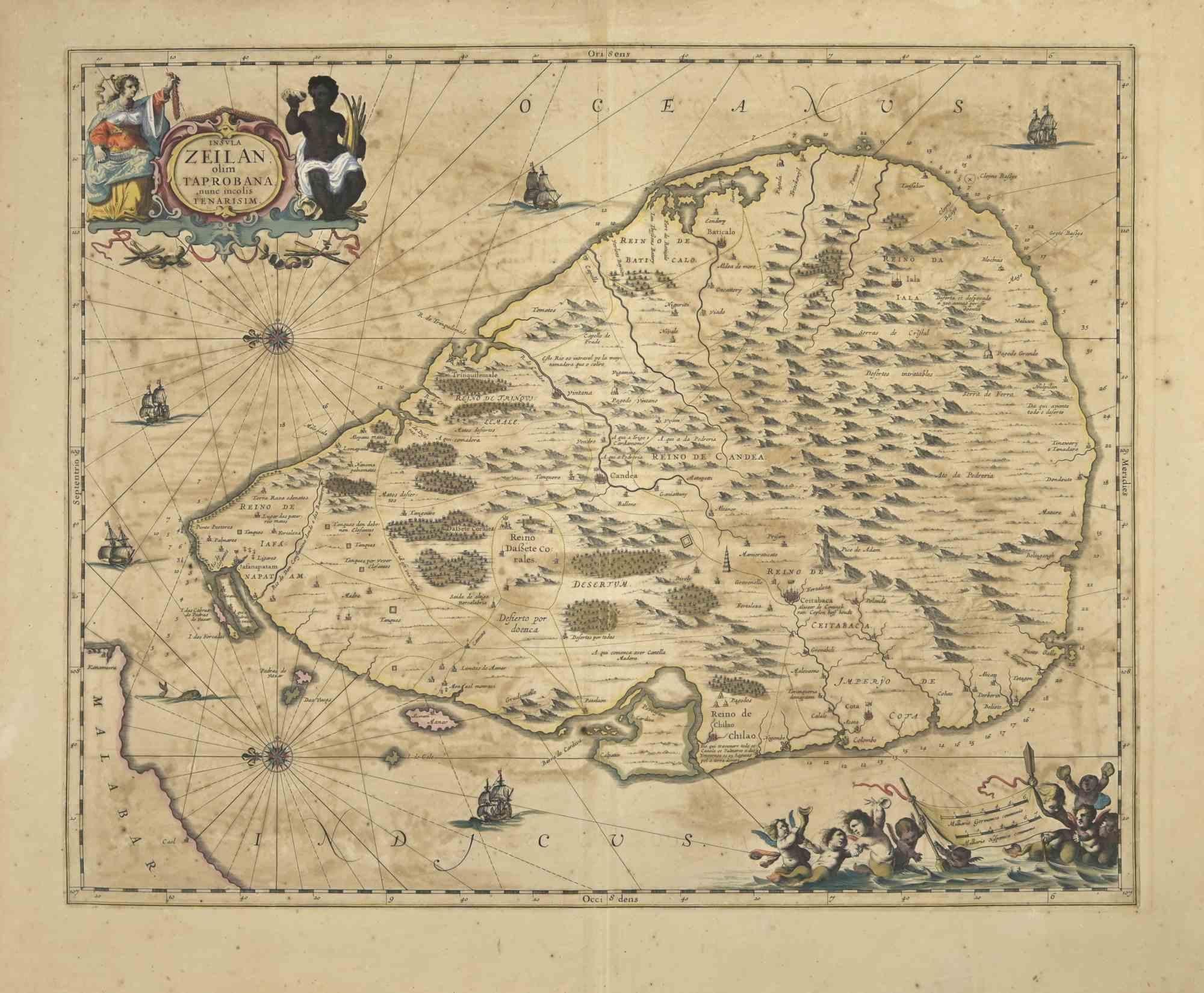
Ancient Map - Zeilan - Etching by Johannes Janssonius - 1650s
By Johannes Janssonius
Located in Roma, IT
Ancient Map - Zeilan is an ancient map realized in 1650 by Johannes Janssonius (1588-1664).
The Map is Hand-colored etching, with coeval watercoloring.
...
Category
1650s Modern Figurative Prints
Materials
Etching

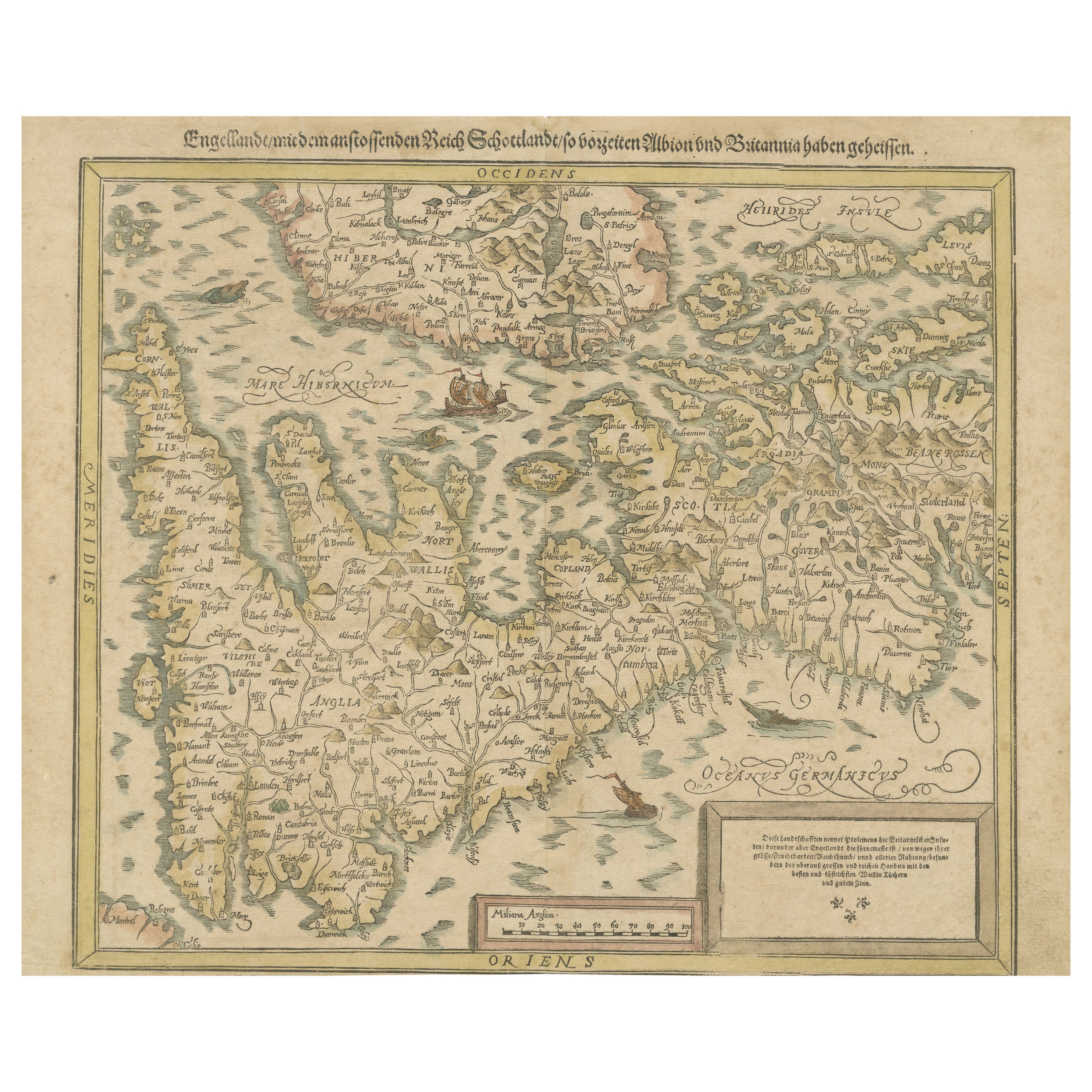
Sebastian Münster's 16th Century Map of the British Isles, ca.1590
Located in Langweer, NL
GREAT BRITAIN -- "ENGELLANDT mit dem anstossenden Reich Schottlandt so vorzeiten Albion und Britannia haben geheissen". (Basel, c. 1590).
Partly handcolored woodcut double-page map from S. Munster's 'Cosmographey'. 330 x 408 mm. (Lower margin cut short (touching the line), tiny hole in upper margin, sl. foxed/browned, lower right corner a bit thumbed).
Sebastian Münster's 16th Century Map of the British Isles from 'Cosmographia Universalis...
Category
Antique 16th Century Maps
Materials
Paper
$612 Sale Price
20% Off
Free Shipping
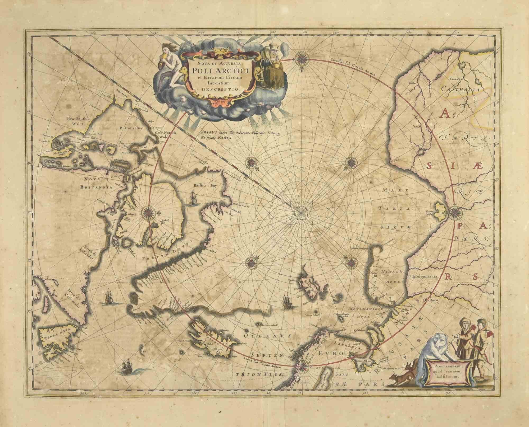
Ancient Map-Poli Arctici (Map of the Poles)-Etching by Johannes Janssonius-1650s
By Johannes Janssonius
Located in Roma, IT
Poli Arctici is an ancient map realized in 1650 by Johannes Janssonius (1588-1664).
The Map is a Hand-colored etching, with coeval watercoloring.
Good conditions with slight foxing...
Category
1650s Modern Figurative Prints
Materials
Etching

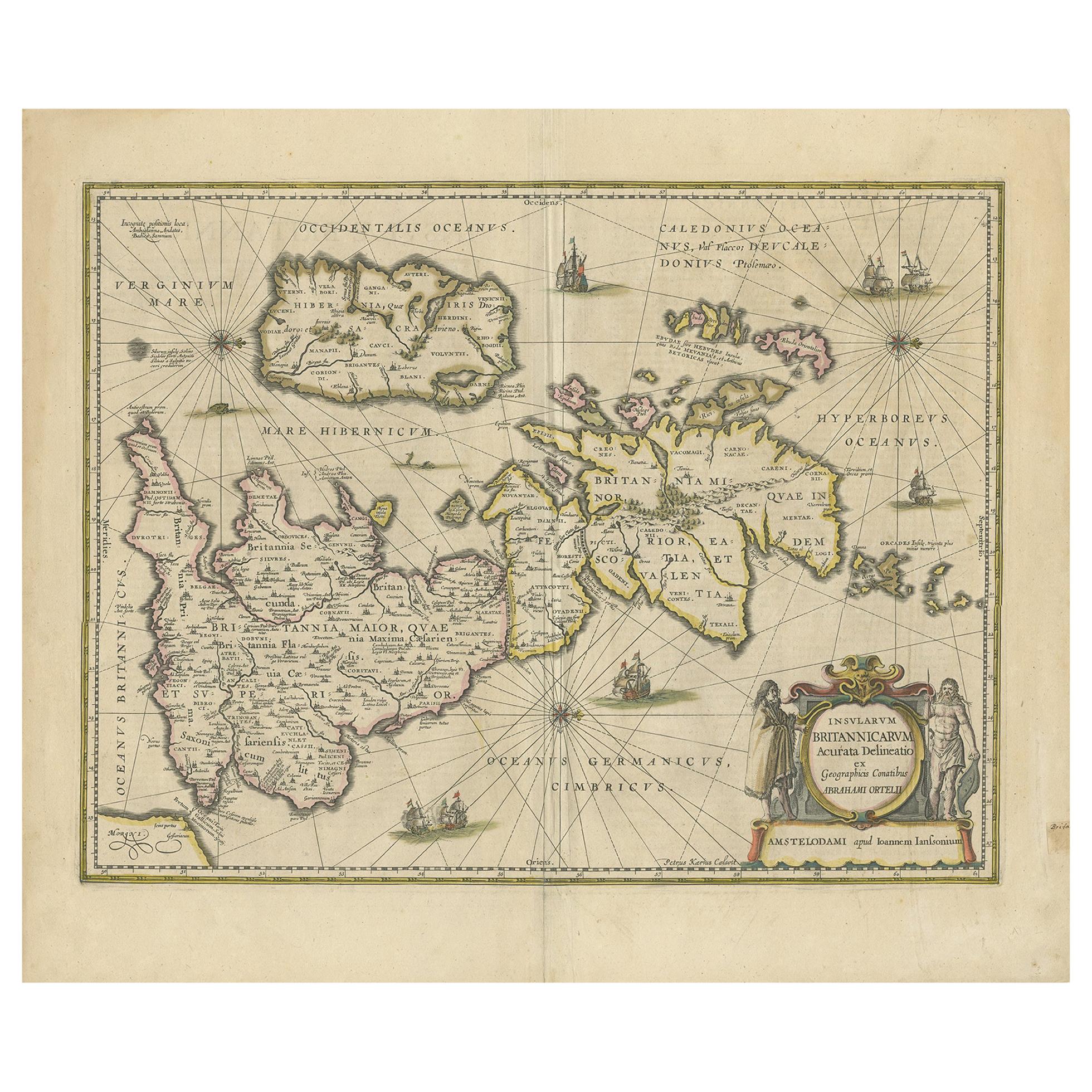
Antique Map of the Ancient British Isles by Janssonius, circa 1640
Located in Langweer, NL
Antique map titled 'Insularum Britannicarum Acurata Delineatio'. Original antique map of the ancient British Isles. England and Wales are labelled as B...
Category
Antique Mid-17th Century Dutch Maps
Materials
Paper

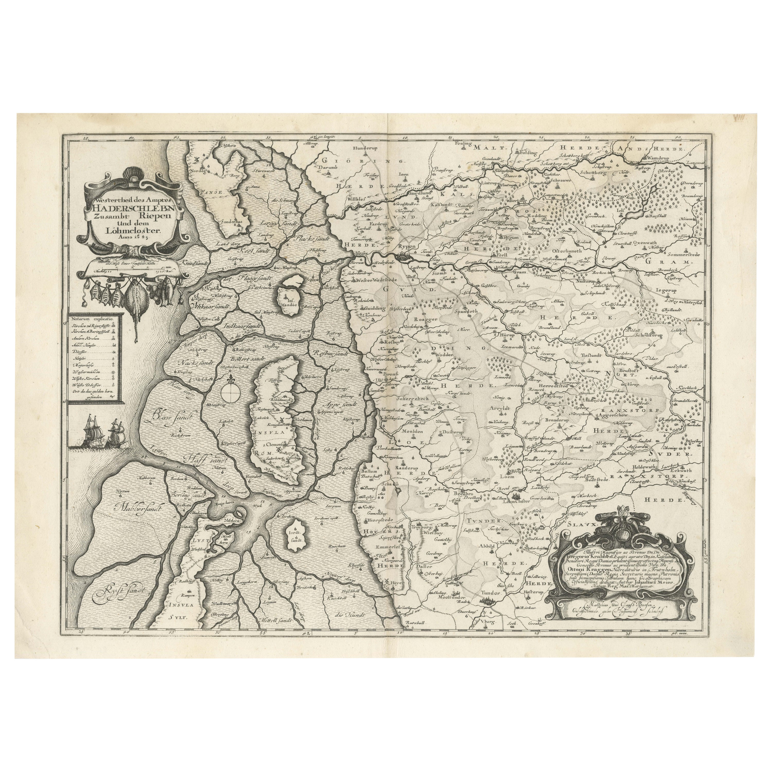
The 1649 Haderschleben Map of Western Jutland and North Sea Islands
Located in Langweer, NL
This is a beautiful example of an antique map, titled "Westertheil des Amptes Haderschleben Zusambt Rieben und dem Loehmcloster Anno 1649." It's a hand-colored copper etching by Matt...
Category
Antique 1640s Maps
Materials
Paper
$592 Sale Price
20% Off
Map of the Netherlands - Etching by G. Braun and F. Hogenberg -Late 16th Century
By Franz Hogenberg
Located in Roma, IT
Map of the Netherlands is an original etching realized by George Braun and Franz Hogenberg, as part of the "Civitates Orbis Terrarum".
The “Civitates Orbis Terrarum” (Atlas of Citi...
Category
16th Century Figurative Prints
Materials
Etching

More Ways To Browse
Antique 17th Century Map
17th Century German
Sea Monster
Antique Galleon
Antique Celestial Globe
Anatomical Print
Mercator Map
17th Century German Engravings
Antique Calipers
Elizabeth Verner
Frances Aronson
Gullah Art
John Mix Stanley
Jonathan Green Lithographs
Jonathan Green Signed Art
Jonathan Green Signed Print
Miami Poster
Monet Style Landscape