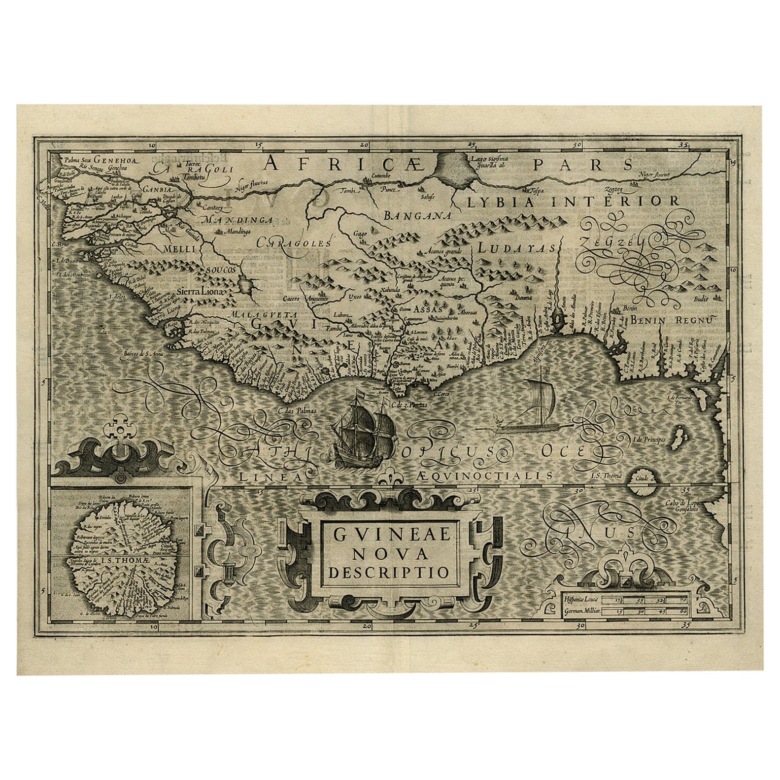
Items Similar to West Africa: A 17th Century Hand-Colored Map by Mercator/Hondius
Want more images or videos?
Request additional images or videos from the seller
1 of 9
Gerard MercatorWest Africa: A 17th Century Hand-Colored Map by Mercator/Hondius1635
1635
$575
£433.61
€501.49
CA$806.72
A$896.72
CHF 470.04
MX$10,951.14
NOK 5,868.21
SEK 5,520.89
DKK 3,742.96
About the Item
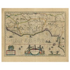
A 17th century hand-colored map entitled "Guineae Nova Descriptio" by Gerard Mercator and Jodocus Hondius, published in their 'Atlas Minor' in Amsterdam in 1635. It is focused on the modern day African countries of Guinea, Sierra Leone, Liberia, Ivory Coast, Ghana, Togo and Benin. A sea monster is seen in the Ethiopicus Ocean (the Gulf of Guinea). A large inset map in the left corner depicts the Island of Isle of Thomae (modern day São Tomé and Príncipe) in detail, which includes the Citadel marked in red. A decorative strapwork cartouche in the lower portion of the map includes the map title.
The map is presented in an archival heather green colored mat. The mat measures 14" wide x 12" high and the map measures 11.25" wide x 7" high. There is English text on the verso. There is mild chipping about the edges, but the map is otherwise in very good condition.
Gerard Mercator (1512-1594) is one of the most famous cartographers of all time. He was born in Flanders and moved to Duisburg from Leuven in the Netherlands, where he lived and worked for the rest of his life. In addition to producing important maps and globes, he invented a projection on maps that presented all parallels and meridians at right angles to each other, with the distance between the parallels extending towards the poles, allowing accurate latitude and longitude calculation and navigational routes to be drawn using straight lines. This was an important technological advance for navigation at sea, as this allowed seafarers to plot their course without having to adjust their course based on frequent compass readings. This has become know as Mercator projection on maps produced by subsequent cartographers to this day. He is also the first to use the term “atlas”, which was first used to describe his collection of maps gathered in one volume. The Mercator atlas was published in 1595, a year after Mercator’s death by his heirs.
Jodocus Hondius (1563-1612) was a prominent globe maker and map engraver from Ghent (Flanders). After spending some time in London, he established his business in Amsterdam in 1593. Hondius bought the plates of Gerard Mercator in 1604 and added around 40 of his own maps in an atlas that he first published in 1606, preserving Mercator's name. After his death in 1612 in Amsterdam, the business was continued by his sons Jodocus II and Henricus, who published the English edition of the Mercator and Hondius Atlas Minor in 1635 that contained this map.
- Creator:Gerard Mercator (1512 - 1594, Flemish, German)
- Creation Year:1635
- Dimensions:Height: 12 in (30.48 cm)Width: 14 in (35.56 cm)
- Medium:
- Period:1630-1639
- Framing:Framing Options Available
- Condition:
- Gallery Location:Alamo, CA
- Reference Number:Seller: # 13041stDibs: LU117328867372
Gerard Mercator
Gerard Mercator (1512-1594) was one of the most famous cartographers of the 16th century and, in fact, of all time. Mercator was known for his strict adherence to scientific methods of the day. He was responsible for advancing the technology of map making. For example his method of representing land masses in a cylindrical projection with north up and south down, first described in 1569, became the standard map projection for navigation. It is still referred to as The Mercator projection.
About the Seller
5.0
Gold Seller
Premium sellers maintaining a 4.3+ rating and 24-hour response times
Established in 2011
1stDibs seller since 2019
289 sales on 1stDibs
Typical response time: 1 hour
- ShippingRetrieving quote...Shipping from: Alamo, CA
- Return Policy
Authenticity Guarantee
In the unlikely event there’s an issue with an item’s authenticity, contact us within 1 year for a full refund. DetailsMoney-Back Guarantee
If your item is not as described, is damaged in transit, or does not arrive, contact us within 7 days for a full refund. Details24-Hour Cancellation
You have a 24-hour grace period in which to reconsider your purchase, with no questions asked.Vetted Professional Sellers
Our world-class sellers must adhere to strict standards for service and quality, maintaining the integrity of our listings.Price-Match Guarantee
If you find that a seller listed the same item for a lower price elsewhere, we’ll match it.Trusted Global Delivery
Our best-in-class carrier network provides specialized shipping options worldwide, including custom delivery.More From This Seller
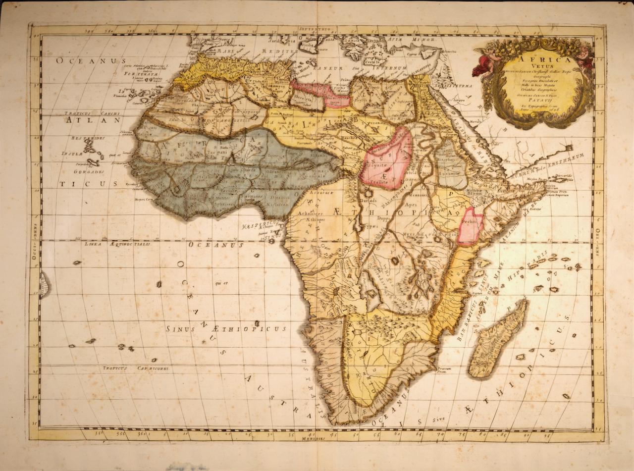
View All"Africa Vetus": A 17th Century Hand-colored Map By Sanson
By Nicholas Sanson d'Abbeville
Located in Alamo, CA
This original hand-colored copperplate engraved map of Africa entitled "Africa Vetus, Nicolai Sanson Christianiss Galliar Regis Geographi" was originally created by Nicholas Sanson d...
Category
1690s Landscape Prints
Materials
Engraving

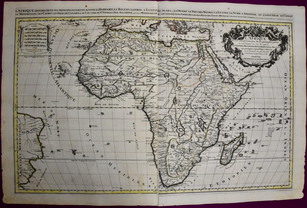
Africa: A Large 17th Century Hand-colored Map By Sanson and Jaillot
By Nicholas Sanson d'Abbeville
Located in Alamo, CA
This large original hand-colored copperplate engraved map of Africa entitled "L'Afrique divisee suivant l'estendue de ses principales parties ou sont distingues les uns des autres, L...
Category
1690s Landscape Prints
Materials
Engraving

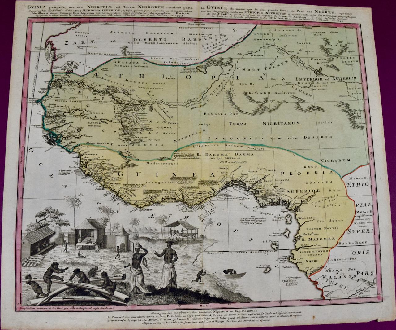
West Africa: 18th Century Hand-colored Homann Map Entitled "Guinea Propria"
By Johann Baptist Homann
Located in Alamo, CA
This is a scarce richly hand colored copper plate engraved map of Africa entitled "Guinea Propria, nec non Nigritiae vel Terrae Nigrorum Maxima Pars" by Johann Baptist Homann (1664-1...
Category
1740s Other Art Style Prints and Multiples
Materials
Engraving

West Coast of Africa; Guinea & Sierra Leone: Bellin 18th Century Map
Located in Alamo, CA
This is a Jacques Bellin copper-plate map entitled "Partie de la Coste de Guinee Dupuis la Riviere de Sierra Leona Jusquau Cap das Palmas", depicting the coast of Guinea and Sierra L...
Category
1740s Old Masters Landscape Prints
Materials
Engraving

Southeastern England: A 17th Century Hand-Colored Map by Mercator and Hondius
By Gerard Mercator
Located in Alamo, CA
A 17th century copperplate hand-colored map entitled "The Sixt Table of England" by Gerard Mercator and Jodocus Hondius, published in Amsterdam in 1635 in 'Cosmographicall Descriptio...
Category
1630s Landscape Prints
Materials
Engraving
Southern Greece: A Large 17th Century Hand-colored Map By Sanson and Jaillot
By Nicholas Sanson d'Abbeville
Located in Alamo, CA
This large original hand-colored copperplate engraved map of southern Greece and the Pelopponese Peninsula entitled "La Moree Et Les Isles De Zante, Cefalonie, Ste. Marie, Cerigo & C...
Category
1690s Landscape Prints
Materials
Engraving

You May Also Like
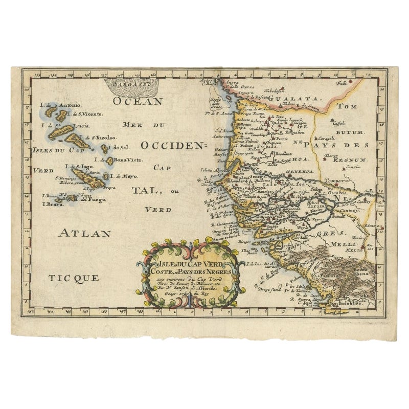
Antique Map of the West African Coast and the Cape Verde Islands, c.1680
Located in Langweer, NL
Antique map Africa titled 'Isles du Cap Verd Coste et Pays des Negres'. Antique map of the coast of Africa and the Cape Verde islands.
Artists and...
Category
Antique 17th Century Maps
Materials
Paper

$343 Sale Price
20% Off
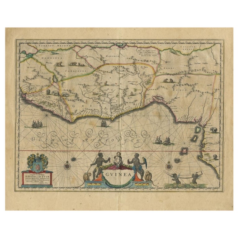
Antique Map of Guinea in West Africa by Blaeu, c.1638
Located in Langweer, NL
Antique map titled 'Guinea'.
Decorative map of West Africa, including numerous animals in the interior, sailing ships and several elegant cartouches. Both the map and the sea are s...
Category
Antique 17th Century Maps
Materials
Paper
$524 Sale Price
20% Off
Old Decorative Map of the West African Coast & St. Thomae Island, c.1600
Located in Langweer, NL
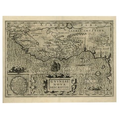
Antique map titled 'Guineae Nova Descriptio.'
This very decorative map shows the West African coast from Senegal (the 'Rio Senega' is the Senegal River) to Cape Lopez on the Gulf...
Category
Antique Early 1600s Maps
Materials
Paper
$1,383 Sale Price
20% Off
Antique Map of the Coast of Africa and the Cape Verde Islands, ca.1680
Located in Langweer, NL
Antique map Africa titled 'Isles du Cap Verd Coste et Pays des Negres'.
Antique map of the coast of Africa and the Cape Verde islands.
Artis...
Category
Antique 1680s Maps
Materials
Paper
$334 Sale Price
20% Off
Map of Cape Verde and the Mouth of the River Niger by Coronelli, 1691
Located in Langweer, NL
Map of Cape Verde and the Mouth of the River Niger by Coronelli, 1691
This finely engraved map, titled "Bocche del Fiume Negro et Isole di Capo Verde," was created in 1691 by Vincen...
Category
Antique Late 17th Century Maps
Materials
Paper
Antique Map - Mar Di Athiopia - Etching by Johannes Janssonius - 1650s
By Johannes Janssonius
Located in Roma, IT
Antique Map - Mar Di Athiopia is an antique map realized in 1650 by Johannes Janssonius (1588-1664).
The Map is Hand-colored etching, with coeval watercolorang.
Good conditions wit...
Category
1650s Modern Figurative Prints
Materials
Etching
