Want more images or videos?
Request additional images or videos from the seller
1 of 14
Herman MollA Framed Hand-colored Early 18th Century Herman Moll Map of Spain and Portugal1711
1711
$2,875List Price
About the Item
- Creator:Herman Moll (1654 - 1732, German)
- Creation Year:1711
- Dimensions:Height: 27.88 in (70.82 cm)Width: 43.13 in (109.56 cm)Depth: 0.88 in (2.24 cm)
- Medium:
- Period:
- Condition:
- Gallery Location:Alamo, CA
- Reference Number:Seller: # 47001stDibs: LU117328772422

Herman Moll
Herman Moll (1654-1732) was a prominent mapmaker in London in the early eighteenth century, having moved from Germany in the late 17th century. He initially worked for English printers, but soon opened his own establishment around 1690. He was a friend of the scientist Robert Hooke, the archaeologist William Stuckley, the authors Jonathan Swift and Daniel Defoe, and the pirates William Dampier, Woodes Rogers and William Hacke. He published many atlases, as well as individual maps. He also produced book illustrations, including maps, for books by the pirate William Dampier and Jonathan Swift’s Gulliver’s Travels. Moll died in 1732.
About the Seller
5.0
Gold Seller
Premium sellers maintaining a 4.3+ rating and 24-hour response times
Established in 2011
1stDibs seller since 2019
291 sales on 1stDibs
Typical response time: 1 hour
Authenticity Guarantee
In the unlikely event there’s an issue with an item’s authenticity, contact us within 1 year for a full refund. DetailsMoney-Back Guarantee
If your item is not as described, is damaged in transit, or does not arrive, contact us within 7 days for a full refund. Details24-Hour Cancellation
You have a 24-hour grace period in which to reconsider your purchase, with no questions asked.Vetted Professional Sellers
Our world-class sellers must adhere to strict standards for service and quality, maintaining the integrity of our listings.Price-Match Guarantee
If you find that a seller listed the same item for a lower price elsewhere, we’ll match it.Trusted Global Delivery
Our best-in-class carrier network provides specialized shipping options worldwide, including custom delivery.You May Also Like
Arrest of Christ, Engraving, a. Karel van Mander, p. by Gheyn, Passion of Chris
Located in Greven, DE
The arrest of Christ; Judas embraces Christ as a group of soldiers apprehend Him; Christ places His hand on the fearful Malchus who sits on the ground holding a lamp; Peter grips his sword; one of the soldiers holds up a flaming torch; after Karel van Mander
The scene is out of a set of 13 engravings "Passion of Christ"
Engraving
Published by: Jacques de Gheyn...
Category
17th Century Northern Renaissance Figurative Prints
Materials
Engraving
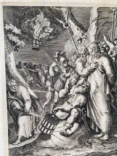
$717 Sale Price
20% Off
H 13.59 in W 9.65 in
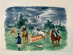
Equestrian Scene
Located in Belgrade, MT
This lithograph is a piece from my private collection of 20th Century School of Paris era artists. It is hand signed by the artist and numbered, Guilde de la Gravure, and is in very ...
Category
Early 20th Century Contemporary Landscape Prints
Materials
Oil, Engraving, Lithograph
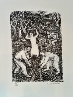
Nature Morte Harvest scene
By Maurice Savin
Located in Belgrade, MT
This lithograph is part of my private collection. It is original and pencil signed an numbered by the artist.
It is one of a kind in black and white.
Category
Mid-20th Century Abstract Expressionist Landscape Prints
Materials
Engraving, Lithograph
Nature Morte country side farming scene
By Maurice Savin
Located in Belgrade, MT
This lithograph is part of my private collection. It is original and pencil signed and numbered by the artist.
Category
20th Century Abstract Expressionist Landscape Prints
Materials
Engraving, Lithograph
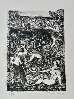
$320 Sale Price
30% Off
H 10.5 in W 7.5 in
1776 Navigational chart/map of the Delaware bay and river including Philadelphia
Located in Philadelphia, PA
JOSHUA FISHER
(AMERICAN, EIGHTEENTH CENTURY)
A Chart of Delaware Bay and River, 1776
Printed for John Bennet and Robert Sayer, London
Engraving on pape...
Category
1770s Realist Landscape Prints
Materials
Paper, Engraving

$5,000
H 19.5 in W 28.25 in
Richard Ziemann 'Ferns' Limited Edition Signed Etching Print
Located in San Rafael, CA
Richard Claude Ziemann (American, b 1932)
'Ferns' 1978-79
Etching on wove paper
Edition 16/100
Titled in pencil lower left
Signed and dated in pencil lower right
Image (plate) : 10in...
Category
Late 20th Century Contemporary Landscape Prints
Materials
Engraving, Etching
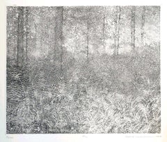
$550
H 16 in W 16 in D 0.05 in
'Sister, A portrait of the Moon' , Signed Etching c2021
Located in Frome, Somerset
'Sister' , by contemporary printmaker and artist Rosie McLay (British)
Edition 59 of 75 in total, handmade etching by the artist.
Ink on paper layed on Dutch gold leaf.
Hand etched ...
Category
2010s Realist Landscape Prints
Materials
Engraving
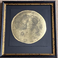
$622
H 17.72 in W 17.72 in D 1.19 in
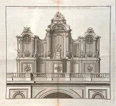
French pipe organ design, late 18th century engraving
Located in Melbourne, Victoria
'Elevation Geometralle d'Un Buffet D'Orgue d'Une Nouvelle Decoration'
Copper-line engraving. C1770.
380mm by 420mm (platemark) 460mm by 560mm (sheet)
From Roubo's 'L'Art du Menui...
Category
Late 18th Century Rococo Landscape Prints
Materials
Engraving
Piccadilly Circus, London, etching by Frederick Farrell, circa 1920
Located in Melbourne, Victoria
Signed in pencil below the image by the artist. Blind stamps of etching societies lower left just under the image.
Frederick Farrell was a Scottish etcher specializing in architectu...
Category
1920s Other Art Style Landscape Prints
Materials
Drypoint, Etching
$550
H 8.08 in W 11.82 in
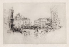
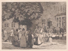
Street Market - Montmatre, France, etching, 1922
Located in Melbourne, Victoria
Monogram and date of etching in the plate bottom left.
220mm by 305mm (platemark) 310mm by 390mm (sheet)
Category
1920s Art Nouveau Landscape Prints
Materials
Drypoint, Etching
More From This Seller
View AllL'Isle de France: A Hand-colored 17th Century Map by De Wit
By Frederick de Wit
Located in Alamo, CA
This colorful and detailed 17th century hand-colored copperplate map by Frederick De Wit was published in Amsterdam between 1666 and 1760. The map depicts the Île-de-France, which is one of the ancient provinces of France. Paris is located in the center of the map, with Versailles to the southwest The map extends from Rouen in the west to Reims in the east. The area around Paris, the Véxin Français, was the original domain of the king of France. Other areas were ruled by French feudal lords. For example, the Véxin Normand area was the domain of the Duke of Normandy...
Category
Early 18th Century Old Masters More Prints
Materials
Engraving

View of Seravalle, Italy: A 16th Century Hand-colored Map by Braun & Hogenberg
By Franz Hogenberg
Located in Alamo, CA
This is an original 16th century copperplate originally hand-colored engraved map of View of Seravalle, Italy entitled "Seravallum Celeberrimum Marchiae Tarvisiniae in Agro Foro Juliensi Opp. - Seravalli, quam vides, Spectator, iconem, operi huic nostro suis sumptib. . . ." by Georg Braun & Franz Hogenberg, from their famous city atlas "Civitates Orbis Terrarum", published in Augsberg, Germany in 1575.
The map depicts a view of Seravalle, now Vittorio Veneto, in San Marino, Italy, north of Venice, in a topographically accurate bird's-eye view from the south. A water-filled moat is seen to the south of the city walls and farmland to the east. Two men are depicted standing on a hill in the lower right in conversation next to grain sacks and a grazing horse, while a younger man behind them to the right herds a mule carrying presumably pigs. A very colorful and ornate title cartouche is in the upper center and coat-of-arms are in the right and left upper corners. Serravalle lies in an idyllic setting in the foothills and surrounded by orchards. St Mary's Cathedral with its tall bell tower is prominent in the center of the town. The marketplace and town hall with a bell tower in the square are depicted. Houses and shops are around the main square. Serravalle's importance as an agricultural centre is emphasized by the figures in the foreground. In 1337 Serravalle was conquered by the Republic of Venice. In 1866 the town was united with neighbouring Ceneda to form the town of Vittorio Veneto.
The following is an English translation of an excerpt from the French description of the city on the back of the map: "Serravalle, a market town renowned for cloth, wine and grain, is in such a beautiful situation that the number of its inhabitants, attracted by the loveliness of the place, has grown so much at times that the wall encircling it has had to be enlarged for the third time. The city with the surrounding town once belonged to the Church in Ceneda as an imperial fief. It subsequently became the seat of the Da Camino family (a princely house that at that time was one of the five most noble in all Italy). Now the city is under the sway of the Venetians but is prudently governed by them. For they send only one city councillor with instructions to ensure that justice prevails and to collect duties. In all else, power lies in the hands of the noble families."
This is a translation of the Latin in the title cartouche on the front: "The picture of the town of Serravalle, which you see, viewer, has been contributed to our work entirely at his own expense by Minutius, son of Hieronymus Minutius, a noble gentleman and one renowned for the far-reaching competence of his jurisdiction. We saw him sojourning in Cologne, where he was on business for Gregory XIII; while our good wishes accompany him, we should also like to accompany him on his way with this remembrance, even though it might be against his will, so that even those who have not seen him may learn of his excellence. However, those who do not yet know him will also see his excellence if God the Almighthy does not summon erring souls too soon back to the eternal seat of the Blessed."
References: Van der Krogt 4, 4728, State 1; Taschen, Braun and Hogenberg, p.331; Fauser, #14960
This striking hand-colored city view is printed on laid, chain-linked paper with wide margins. The sheet measures 16" high by 21" wide. There is a central vertical fold as issued and French text on the verso, with Latin on the front. There is some discoloration in the upper and right margins which may represent some watercolor paint from the time of the original hand-coloring of the map. There is a small hole to the right of the upper portion of the vertical fold, which is only visible when held up to light and an area of reinforcement on the verso of the lower vertical fold. The map is otherwise in very good to excellent condition.
Braun and Hogenberg's 'The Civitates Orbis Terrarum' was the second atlas of maps ever published and the first atlas of cities and towns of the world. It is one of the most important books published in the 16th century. Most of the maps in the atlas were engraved by Franz Hogenberg and the text, with its descriptions of the history and additional factual information of the cities, was written by a team of writers and edited by Georg Braun. The work contained 546 bird-eye views and map views of cities and towns from all over the world. It gave graphic representation of the main features of the illustrated cities and towns, including the buildings and streets. Although the ordinary buildings are stylized, the principal buildings are reproduced from actual drawings created on location. The principal landmarks and streets can still be recognized today. In addition, the maps often include the heraldic arms of the city, the nature of the surrounding countryside, the important rivers, streams and harbors, even depicting stone bridges, wooden pontoons, flat-bottomed ferries, ships and working boats, wharves and jetties, as well as land-based activities, including horsemen, pedestrians, wagons, coaches, and palanquins. Small vignettes are often included which illustrate the trade, occupations and habits of the local inhabitants, such as agriculture, paper-making and textiles, as well as local forms of punishment, such as gibbets, wheels, floggings etc. Large figures dressed in their local costume are often presented out of proportion in the foreground. The aim of the authors was to give as much information as possible in a pleasing visual form. They succeeded in creating maps that were both informative and decorative works of art. The atlas is a wonderful glimpse of life in medieval Europe.
Georg Braun (1541-1622) was German Catholic...
Category
16th Century Old Masters Landscape Prints
Materials
Engraving

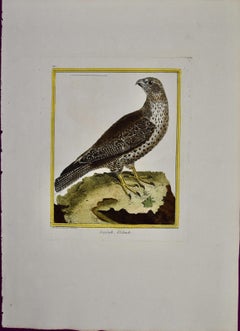
An Icelandic GyrFalcon: An 18th Century Hand-colored Engraving by Martinet
By François Nicolas Martinet
Located in Alamo, CA
This is a hand-colored engraving of an Icelandic Ger Falcon entitled "Gerfault d''Islande" by Francois Nicolas Martinet, plate 210 from 'Histoire Naturelle des Oiseaux' in associatio...
Category
1760s Naturalistic Animal Prints
Materials
Engraving
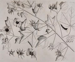
"Katu-Belluren": A 17th Century Botanical Engraving by Hendrik van Rheede
Located in Alamo, CA
This is a 17th century engraving of a vine spinach plant entitled "Katu-Belluren" by Hendrik van Rheede tot Drakenstein, plate 46 from his 'Hortus Indicus M...
Category
Late 17th Century Naturalistic Landscape Prints
Materials
Engraving
China: An Original 18th Century Hand-colored Map by E. Bowen
Located in Alamo, CA
This is an original 18th century hand-colored map entitled "A New & Accurate Map of China, Drawn from Surveys made by the Jesuit Missionaries, by order of the Emperor. The whole bein...
Category
Mid-18th Century Old Masters Landscape Prints
Materials
Engraving

Bermuda: An Early 17th Century Hand-colored Map by Henricus Hondius
By Henricus Hondius
Located in Alamo, CA
This attractive and interesting map of Bermuda by Henricus Hondius in 1633 is entitled "Mappa Aestivarum Insularum, Alias Barmudas". It is based on a ...
Category
Early 17th Century Old Masters Landscape Prints
Materials
Engraving

Recently Viewed
View AllMore Ways To Browse
Pirate Antique
18th Century Spanish Frame
Daniel Defoe
William Dampier
Queen Mary Portrait
Smoking Hat
Stanton Gray
Susan George
Tall Metal Abstract Sculpture
Tattoo Nude
Toshio Iezumi
Used Cremation Urns
Vintage Beach Boys
Vintage Electric Chair
Vintage Taxi Cabs
Wild Bunch
Yves Klein Blue
1950 Fashion Illustrations