Items Similar to Map of Northumberland by Joan Blaeu

Want more images or videos?
Request additional images or videos from the seller
1 of 9
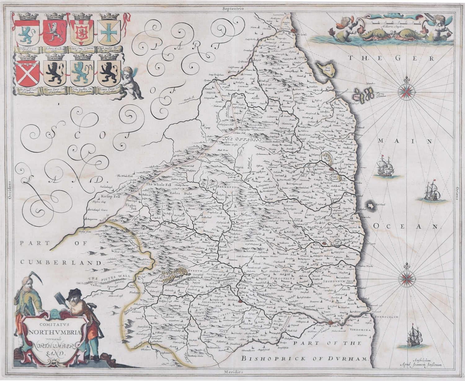
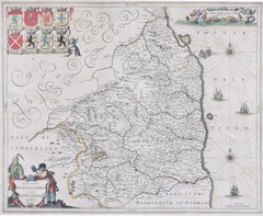
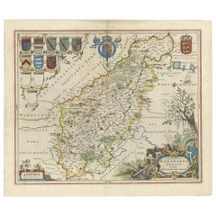
Joan (Johannes) BlaeuMap of Northumberland by Joan Blaeu1662
1662
$1,024.24
£750
€873.05
CA$1,411.08
A$1,537.83
CHF 814.34
MX$18,470.90
NOK 10,309.78
SEK 9,478.83
DKK 6,520.69
About the Item
To see our other original maps, scroll down to "More from this Seller" and below it click on "See all from this Seller" - or send us a message if you cannot find the poster you want.
Johannes 'Joan' Blaeu (1596 - 1673)
Comitatus Northumbria, Vernacular Northumberland (1662)
Engraving with later hand-colouring
43 x 52 cm
A decorative map of Northumberland by the celebrated Dutch mapmaker and artist Joan Blaeu, (son of the cartographer Willem Blaeu). Crests of the local gentry appear in the top right hand corner.
Blaeu moved to Amsterdam in 1920 to join the family firm of mapmakers. In 1635, the business published the Theatrum orbis terrarum, sive, Atlas novus in two volumes - the largest and most expensive book published in the seventeenth century, and the venture for which the Blaeu were most famed. Joan and his brother Cornelius took over the studio after their father died in 1638; Joan became the official cartographer for the Dutch East India Company, as his father had been before him.
- Creator:Joan (Johannes) Blaeu (1596 - 1673)
- Creation Year:1662
- Dimensions:Height: 16.93 in (43 cm)Width: 20.48 in (52 cm)
- Medium:
- Period:1660-1669
- Condition:Very good.
- Gallery Location:London, GB
- Reference Number:1stDibs: LU795313316702
About the Seller
4.8
Vetted Professional Seller
Every seller passes strict standards for authenticity and reliability
Established in 2014
1stDibs seller since 2017
362 sales on 1stDibs
Typical response time: 13 hours
- ShippingRetrieving quote...Shipping from: London, United Kingdom
- Return Policy
More From This Seller
View AllMap of Northumberland by Joannem Janssonium 17th century
Located in London, GB
To see our other original maps, scroll down to "More from this Seller" and below it click on "See all from this Seller" - or send us a message if you cannot find the poster you want....
Category
1640s Landscape Prints
Materials
Engraving
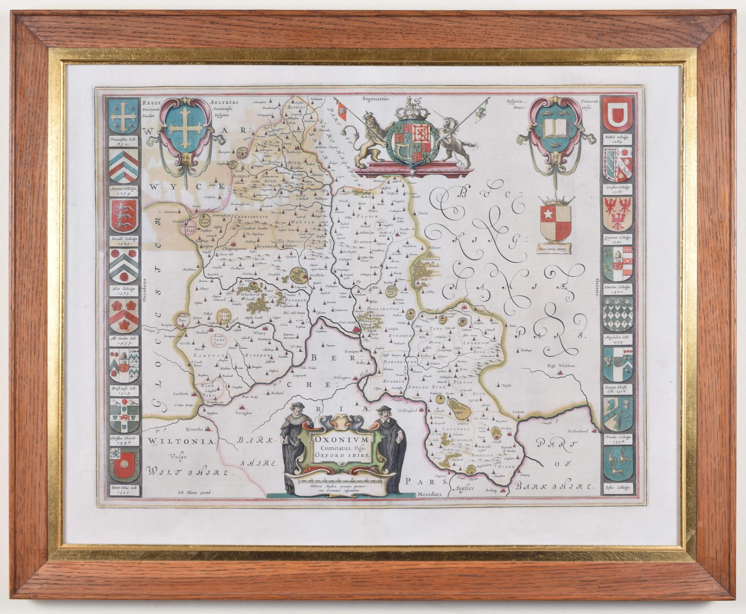
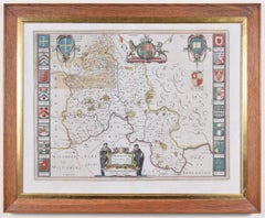
Map of Oxfordshire by Joan Blaeu with college crests
By Joan (Johannes) Blaeu
Located in London, GB
To see our other original maps, scroll down to "More from this Seller" and below it click on "See all from this Seller" - or send us a message if you cannot find the poster you want....
Category
1660s Landscape Prints
Materials
Engraving
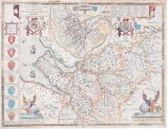
Cambridgeshire map 17th century engraving by John Speed
By John Speed
Located in London, GB
To see more, scroll down to "More from this Seller" and below it click on "See all from this Seller."
John Speed (1551 or 1552 - 1629)
Map of Cambridgeshire
Engraving with later hand colouring
39 x 53 cm
A beautifully coloured map of Cambridgeshire, with an antique description...
Category
1610s Landscape Prints
Materials
Engraving

John Speede Map The Countye Palatine of Chester with that most ancient citie
By John Speed
Located in London, GB
To see our other views and maps of England - including London, Oxford and Cambridge, scroll down to "More from this Seller" and below it click on "See all from this Seller" - or send...
Category
17th Century Realist Landscape Prints
Materials
Engraving
John Speede Map The Countye of Monmouth
By John Speed
Located in London, GB
To see our other views and maps of England - including London, Oxford and Cambridge, scroll down to "More from this Seller" and below it click on "See all from this Seller" - or send...
Category
17th Century Realist Landscape Prints
Materials
Engraving

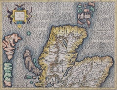
Map of the North of Scotland 17th century hand-coloured map by Gerardus Mercator
Located in London, GB
Gerardus Mercator (1512 - 1594)
Map of the North of Scotland (1683)
Engraving with later hand colouring
35 x 45 cm
A fantastically characterful and detailed map engraving of the North of Scotland from 1683. The highly detailed and beautifully coloured map is inscribed to the reverse with a description of the parts of Scotland illustrated, called the 'Troisieme Table d'Escosse'. The map comes from the 1683 French edition of Gerardus Mercator's Atlas Major, which was first published in 1585.
Gerardus Mercator was the Flemish father of mapmaking. He was a skilled geographer, cosmographer and cartographer and is most renowned for creating the 1569 world map based on a new projection which represented sailing courses of constant bearing (rhumb lines) as straight lines - an innovation that is still employed in today's nautical charts.
Mercator was a highly influential pioneer in the history of cartography and is generally considered one of the founders of the Netherlandish school of cartography and geography. He is also widely considered the most notable figure of the school. In his own day, he was a notable maker of globes and scientific instruments. In addition, he had interests in theology, philosophy, history, mathematics and geomagnetism. He was also an accomplished engraver and calligrapher. Unlike other great scholars of the age, he travelled little and his knowledge of geography came from his library of over a thousand books and maps, from his visitors and from his vast correspondence (in six languages) with other scholars, statesmen, travellers, merchants and seamen. Mercator's early maps were in large formats suitable for wall mounting but in the second half of his life, he produced over 100 new regional maps in a smaller format suitable for binding into his Atlas of 1595. This was the first appearance of the word Atlas in reference to a book of maps...
Category
1680s Prints and Multiples
Materials
Engraving
You May Also Like
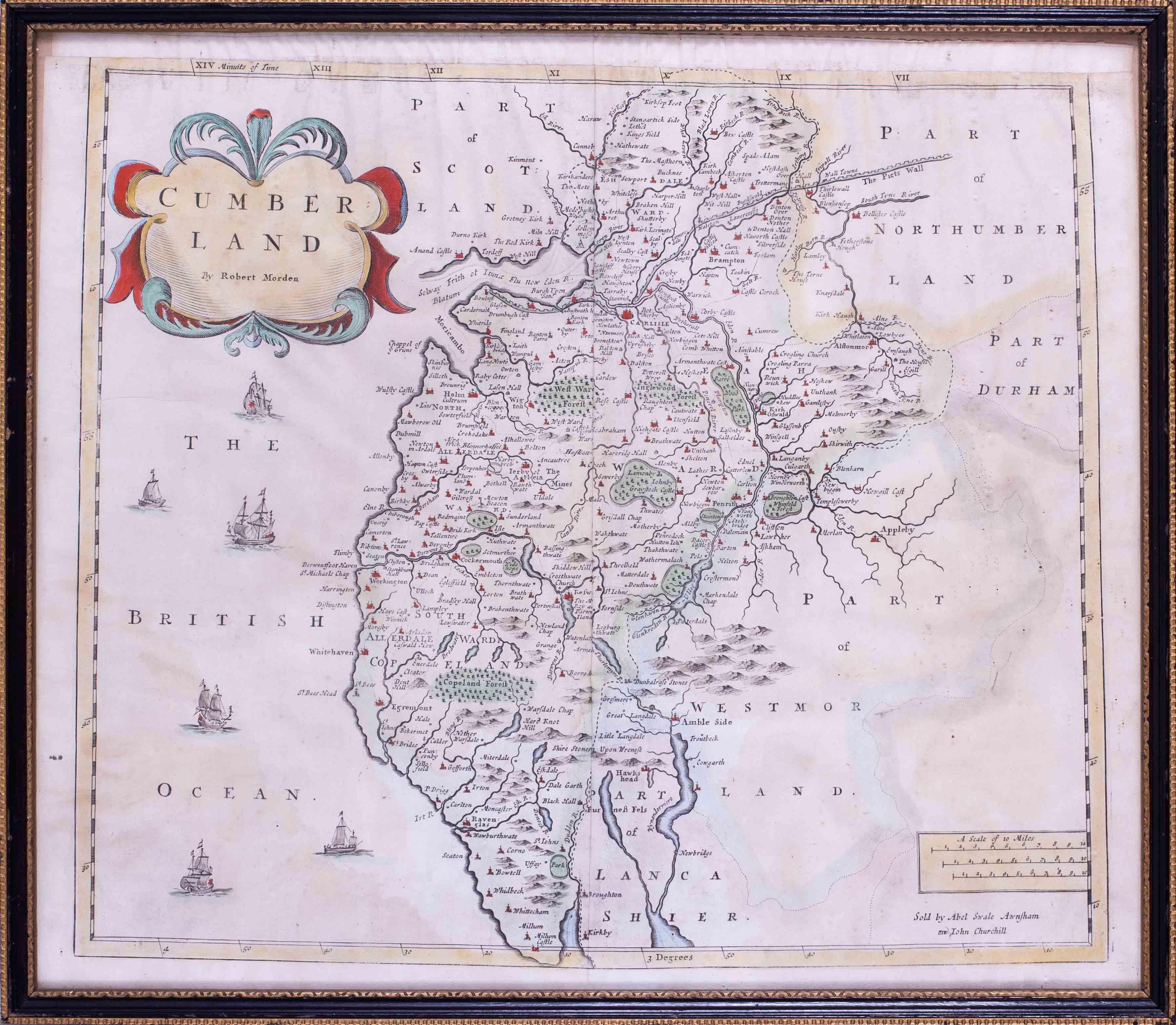
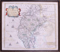
17th Century map of Cumberland, UK by Robert Morden
Located in Petworth, West Sussex
Robert Morden (British, circa 1650 – 1703)
A map of Cumberland with hand colouring
An engraving
14.1/4 x 16.5/8 in. (36.5 x 42.5 cm.)
Category
17th Century Academic Landscape Prints
Materials
Engraving
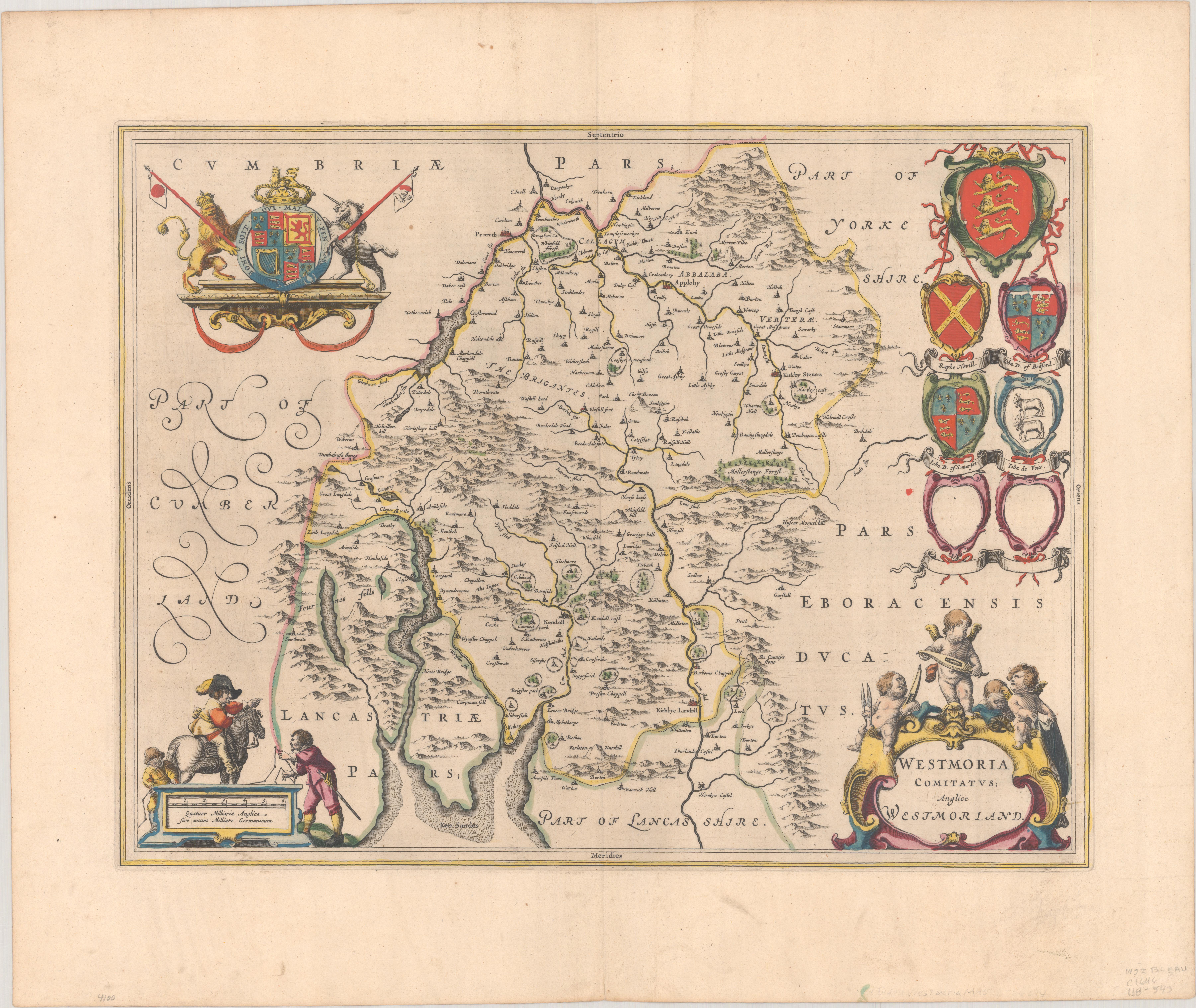
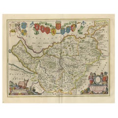
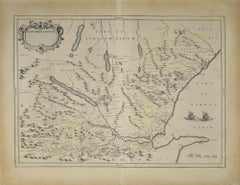
1645 Blaeu Map of Westmorland, Northern England – Hand Colored, Decorative
Located in Langweer, NL
This map, "Westmoria Comitatus; Anglice Westmorland", was created by the esteemed Dutch cartographer Willem Blaeu and was published around 1645 in 'Le Theatre du Monde ou Nouvel Atlas'. It provides a detailed look at Westmorland, a historic county in northern England, based on John Speed’s earlier map. The map features numerous place names, parks, and estates, including Brigster Park, Colnhead Park, Crosbye, and Midleton, along with a detailed depiction of Windermere (spelled Wynandermere) and the surrounding regions.
Additional Features:
- Hand-colored map, with vibrant and detailed colors that bring out the topographical and decorative features.
- Includes intricate cartouches, such as the royal coat of arms, a decorative title cartouche topped with putti (cherubic figures), and six coats of arms (two left blank).
- Depicts the region’s rich landscape, including the rolling hills and mountainous terrain of northern England.
- French text on the verso, indicative of the publication period from 1645-1648, part of Blaeu’s highly sought-after atlases.
- Map shows precise details of small towns, estates, and parks, such as Brigster Park, Colnhead Park, Crosbye, and Wynandermere (now Windermere Lake).
This map would be of particular interest to collectors of English county maps, antique maps of northern England, 17th-century cartography, and the decorative works of Willem Blaeu. Blaeu's maps are renowned for their accuracy, artistic beauty, and historical significance.
Keywords: Willem Blaeu, Westmorland map, northern England, 17th-century map, antique map, English county map, John Speed, Windermere, decorative cartography, hand-colored map, rare map, antique cartography...
Category
Antique 1640s Dutch Maps
Materials
Paper
$1,047 Sale Price
30% Off
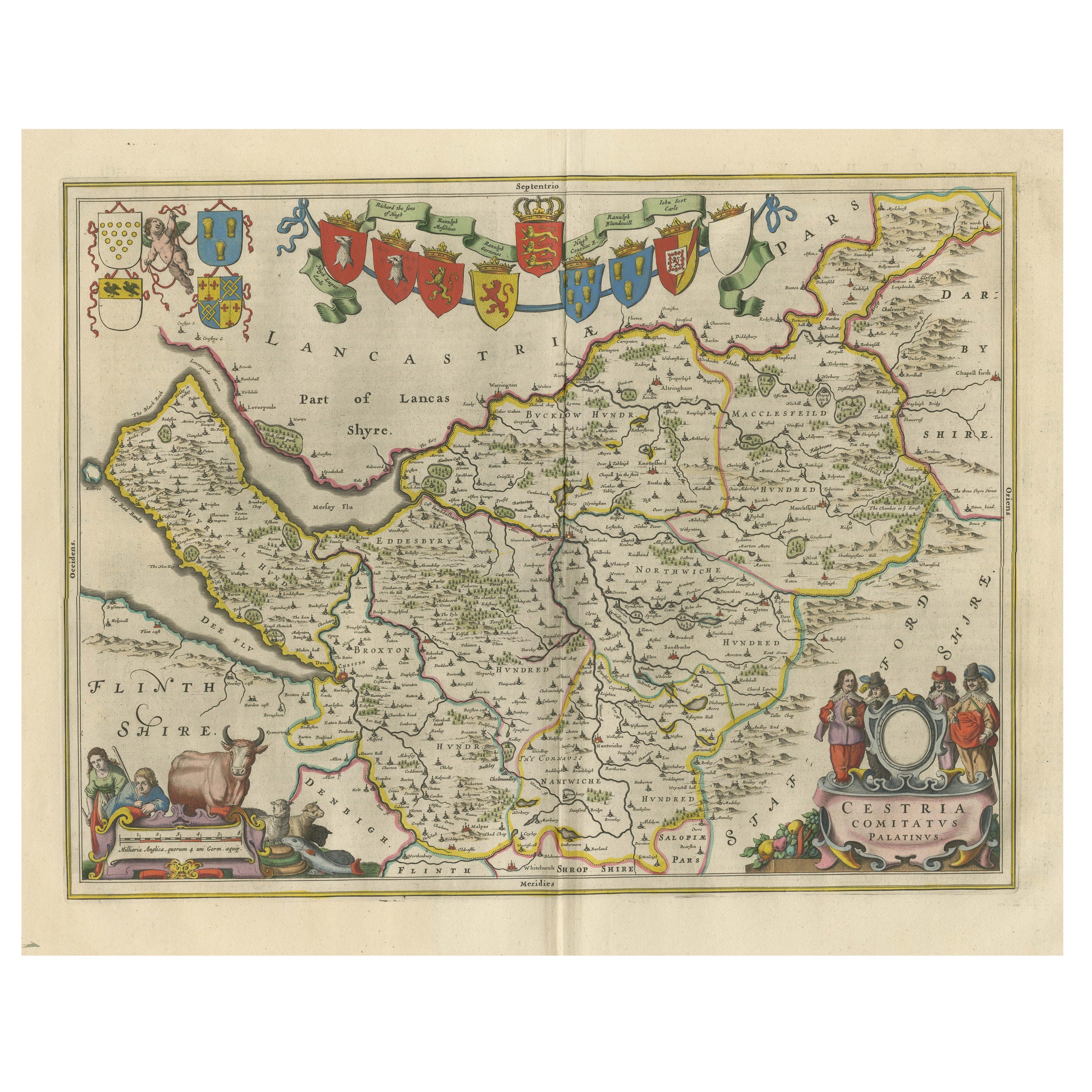
Antique Map of Cheshire, North West England
By Joan (Johannes) Blaeu
Located in Langweer, NL
Antique map titled 'Cestria comitatus Palatinus'. Original old map of Cheshire, Northwest England. Published circa 1665 by J. Blaeu. Willem Jansz. Blaeu and his son Joan Blaeu are th...
Category
Antique Mid-17th Century Maps
Materials
Paper
$1,148 Sale Price
20% Off
Antique Map of the Region of Le Mans 'France' by Blaeu, circa 1640
By Willem Blaeu
Located in Langweer, NL
Antique Map: Cenomanorum Galliae regionis typus vulgo le Mans – Blaeu, circa 1640
This beautifully engraved and hand-colored map depicts the historical province of Maine in northw...
Category
Antique Mid-17th Century Maps
Materials
Paper

$478 Sale Price
20% Off
Free Shipping
Map of Scotland - Etching by Johannes Blaeu - 1650s
Located in Roma, IT
Map of Scotland is an geographic map realized by Johannes Blaeu.
Etching, printed in 1660 ca.
Copper engraving, colored (coeval coloring), on paper, with center fold;
Latin text. ...
Category
1650s Modern Figurative Prints
Materials
Etching
$448 Sale Price
20% Off
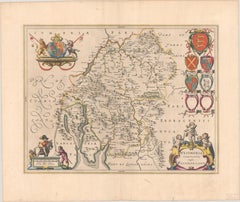
A Gold Highlighted Antique Map of Northamptonshire by Blaeu '1659'
Located in Langweer, NL
Antique map titled 'Comitatus Northantonensis vernacule Northamtonshire'. Original antique map of Northamptonshire, England. This map originates from 'Atlas Universal y Cosmographico...
Category
Antique Mid-17th Century Maps
Materials
Paper
More Ways To Browse
East India Company
Dutch East India Company
Blaeu Maps
Joan Blaeu
Jules Cavailles On Sale
Lichtenstein Haystack
Lightning Plane
Michael Schofield On Sale
Monet Signed Prints
Palestine Wall Art
Queensboro Bridge
R Marsh
Richard Devonshire
Rowland Langmaid
Sncf Dali
Spring Song Vintage Print
Thomas Moran Etching
Used Porta John