Items Similar to Danube River, Italy, Greece and Croatia: A Hand-colored 18th C. Homann Map
Want more images or videos?
Request additional images or videos from the seller
1 of 16
Johann Baptist HomannDanube River, Italy, Greece and Croatia: A Hand-colored 18th C. Homann Map1728
1728
$875
£662.28
€762.61
CA$1,244.78
A$1,348.40
CHF 709.99
MX$16,366.83
NOK 8,854.46
SEK 8,371.68
DKK 5,693.08
About the Item
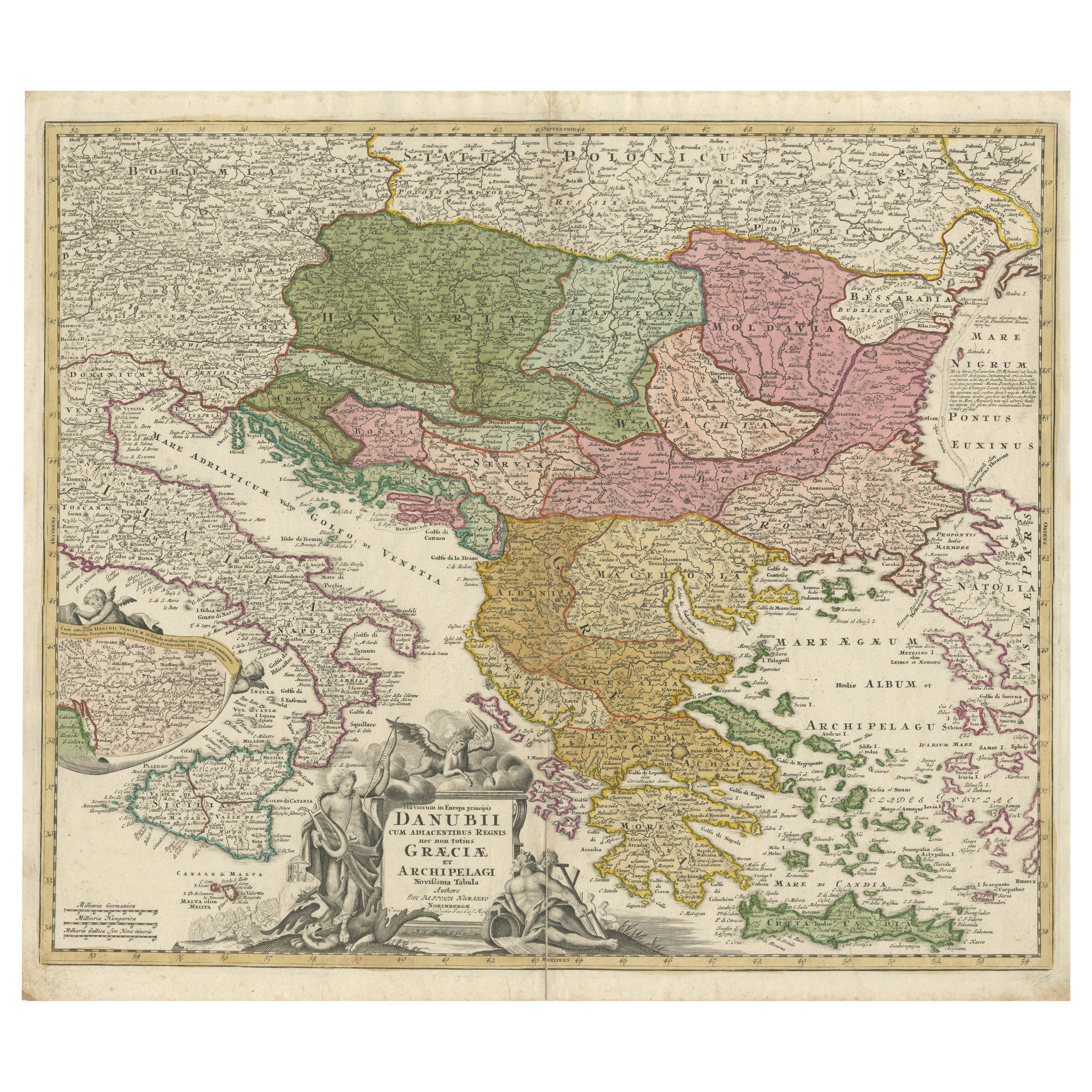
"Fluviorum in Europa principis Danubii" is a hand-colored map of the region about the Danube river created by Johann Baptist Homann (1663-1724) in his 'Atlas Novus Terrarum', published in Nuremberg, Germany in 1728 shortly after his death. It depicts the course of the river Danube from Ingolstadt to the Black Sea, as well as the Adriatic and Aegean Seas. It extends from Bohemia in the north to Crete in the south, including Italy, Greece, Croatia and other portions of the Balkans. There is a striking decorative cartouche and a large inset map of the Upper Danube region and excellent detail of the Greek and Croatian islands, as well as the straits from the Aegean into the Black Sea.
There is a central vertical fold as issued, with mild separation inferiorly, which is reinforced on the verso, as is a small vertical tear in the upper margin. The map is otherwise in very good condition.
Johann Baptist Homann (1663-1724) was a mapmaker who founded a respected and prolific publishing company, which continued long after his death as Homann Heirs. Homann lived his entire life in Bavaria, particularly in Nuremberg. Initially, Johann trained to become a priest before converting to Protestantism and working as a notary. In 1702, Johann founded a publishing house that specialized in engravings. The firm flourished, becoming the leading map publisher in Germany and an important entity in the European map market. In 1715, Johann was named Imperial Geographer to the Holy Roman Empire by Charles VI and made a member of the Prussian Academy of Sciences. Most importantly for his business, his reputation and contacts gained him imperial printing privileges which protected his publications and recommended him to customers.
- Creator:Johann Baptist Homann (1664 - 1724, German)
- Creation Year:1728
- Dimensions:Height: 20 in (50.8 cm)Width: 23.88 in (60.66 cm)Depth: 0.07 in (1.78 mm)
- Medium:
- Movement & Style:
- Period:
- Framing:Framing Options Available
- Condition:
- Gallery Location:Alamo, CA
- Reference Number:Seller: #12831stDibs: LU117328209352

Johann Baptist Homann
Johann Baptist Homann (1663-1724) was a mapmaker who founded a respected and prolific publishing company, which continued long after his death as Homann Heirs. Homann lived his entire life in Bavaria, particularly in Nuremberg. Initially, Johann trained to become a priest before converting to Protestantism and working as a notary. In 1702, Johann founded a publishing house that specialized in engravings. The firm flourished, becoming the leading map publisher in Germany and an important entity in the European map market. In 1715, Johann was named Imperial Geographer to the Holy Roman Empire by Charles VI and made a member of the Prussian Academy of Sciences. Most importantly for his business, his reputation and contacts gained him imperial printing privileges which protected his publications and recommended him to customers.
About the Seller
5.0
Platinum Seller
Premium sellers with a 4.7+ rating and 24-hour response times
Established in 2011
1stDibs seller since 2019
293 sales on 1stDibs
Typical response time: 1 hour
- ShippingRetrieving quote...Shipping from: Alamo, CA
- Return Policy
Authenticity Guarantee
In the unlikely event there’s an issue with an item’s authenticity, contact us within 1 year for a full refund. DetailsMoney-Back Guarantee
If your item is not as described, is damaged in transit, or does not arrive, contact us within 7 days for a full refund. Details24-Hour Cancellation
You have a 24-hour grace period in which to reconsider your purchase, with no questions asked.Vetted Professional Sellers
Our world-class sellers must adhere to strict standards for service and quality, maintaining the integrity of our listings.Price-Match Guarantee
If you find that a seller listed the same item for a lower price elsewhere, we’ll match it.Trusted Global Delivery
Our best-in-class carrier network provides specialized shipping options worldwide, including custom delivery.More From This Seller
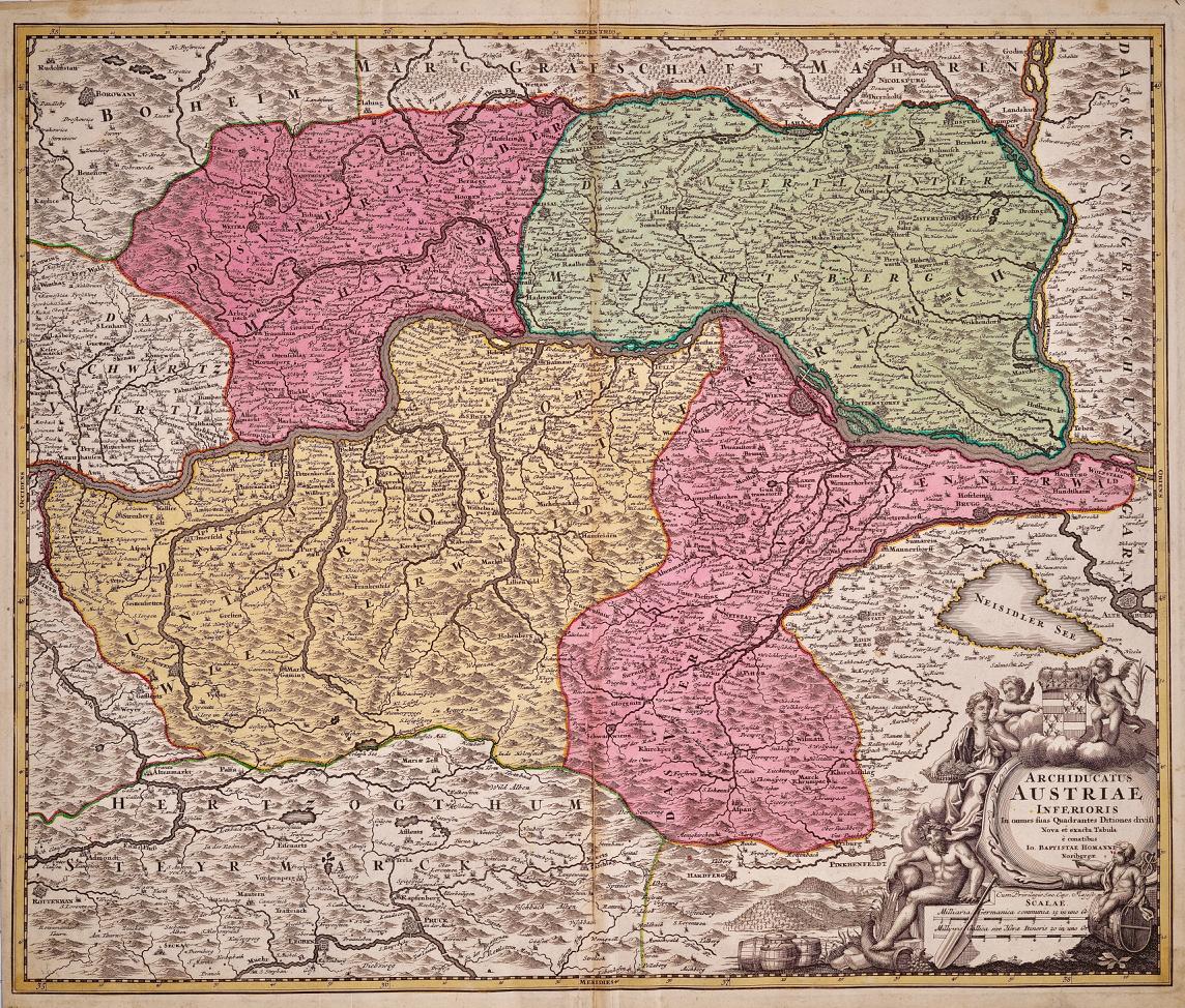
View AllHand Colored 18th Century Homann Map of Austria Including Vienna & the Danube
By Johann Baptist Homann
Located in Alamo, CA
"Archiducatus Austriae inferioris" is a hand colored map of Austria created by Johann Baptist Homann (1663-1724) and published in Nuremberg, Germany in 1728 shortly after his death. ...
Category
Early 18th Century Old Masters Landscape Prints
Materials
Engraving

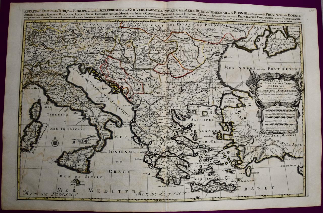
Southern & Eastern Europe: A Large 17th C. Hand-colored Map by Sanson & Jaillot
By Nicholas Sanson d'Abbeville
Located in Alamo, CA
This large hand-colored map entitled "Estats de L'Empire des Turqs en Europe, ou sont les Beglerbeglicz our Gouvernements" was originally created by Nicholas Sanson d'Abbeville and this version was published by Hubert Jaillot in "Atlas Nouveau" in Paris in 1692. It depicts the territories of the Ottoman Empire in Europe, predominantly Eastern Europe. Highlights include, the Mediterranean Sea, the Adriatic Sea, the Black Sea, the Dalmation Coast including present day Croatia, Bosnia and Herzegovina, Montenegro, Serbia, Slovenia, Italy, Greece, North Macedonia, Turkey, Romania, Hungary, Albania, Kosovo, Bulgaria, Transylvania, Moldova and southern portions of France, Switzerland, Germany, and Poland..
The map consists of two sheets joined as one along a vertical joint. The map has original hand-coloring. It is printed on antique hand-made laid, chain-linked paper with wide margins. The sheet measures 24.88" high and 38" wide. There is a central vertical joint, as issued. The map is in very good condition.
Nicholas Sanson d'Abbeville (1600-1667) was one of the greatest French cartographather of French cartography. Sanson opened his first printing business in Paris in 1638. The king recognized his skill and knowledge and made him the official geographer to the court. He eventually served two kings in this capacity. Sanson was succeeded by his sons and son...
Category
1690s Landscape Prints
Materials
Engraving

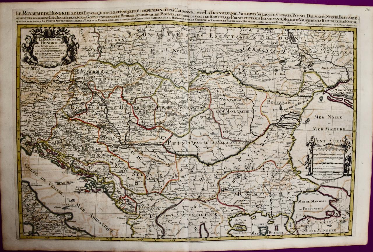
Hungary & Eastern Europe: A Large 17th C. Hand-colored Map by Sanson & Jaillot
By Nicholas Sanson d'Abbeville
Located in Alamo, CA
This large hand-colored map entitled "Le Royaume De Hongrie et les Estats qui en ont este sujets et qui font presentement La Partie Septentrionale de la Turquie en Europe" was origin...
Category
1690s Landscape Prints
Materials
Engraving

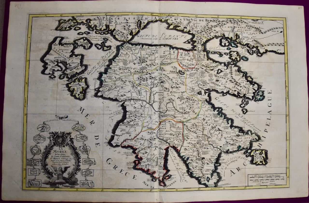
Southern Greece: A Large 17th Century Hand-colored Map By Sanson and Jaillot
By Nicholas Sanson d'Abbeville
Located in Alamo, CA
This large original hand-colored copperplate engraved map of southern Greece and the Pelopponese Peninsula entitled "La Moree Et Les Isles De Zante, Cefalonie, Ste. Marie, Cerigo & C...
Category
1690s Landscape Prints
Materials
Engraving

Europa Regnorum Provinciarum: 18th Century Hand-colored Map of Europe by Lotter
By Tobias Conrad Lotter
Located in Alamo, CA
This is an 18th century hand-colored copperplate engraved map entitled "Europa Regnorum Provinciarum Regionum" created by the German cartographer Tobias Conrad Lotter. It was publish...
Category
Mid-18th Century Landscape Prints
Materials
Engraving

Mediterranean and Adriatic Seas: Original 18th Century Hand-colored Map by Bowen
Located in Alamo, CA
This is an original 18th century hand-colored map entitled "An Accurate Chart of The Mediterranean and Adriatic Sea's; with the Archipelago & Part of the Black Sea. Exhibiting all th...
Category
Mid-18th Century Old Masters Landscape Prints
Materials
Engraving

You May Also Like
Greece and Ottoman Balkans Map – Homann Engraving ca. 1720
Located in Langweer, NL
Greece and the Danube Basin Map c.1720 – Antique Engraving of the Balkans
This remarkable early 18th-century map presents a sweeping view of southeastern Europe, centering on the co...
Category
Antique 18th Century German Maps
Materials
Paper

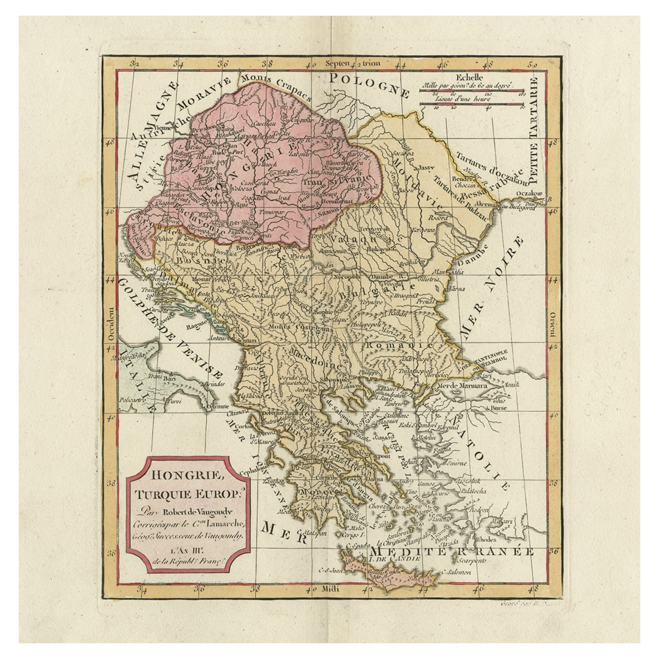
Old Engraved Map of Hungary, European Balkan Countries, Greece and Crete, 1806
Located in Langweer, NL
Antique map titled 'Hongrie, Turquie Europe'.
Decorative map of Hungary, southeast European countries in the Balkan peninsula and Greece by Robert de Vaugondy, revised and publis...
Category
Antique 19th Century Maps
Materials
Paper

$429 Sale Price
20% Off
Stunning Antique Map of Northern Italy by J.B. Homann, circa 1745
By Johann Baptist Homann
Located in Langweer, NL
This beautiful hand-colored map covers from Bergamo east as far as Albona (Labin) and from Vipiteno Sterzing south as far as Florence.
The map is exceptionally detailed, noting towns, rivers, lakes, cities and a host of additional topographical features. Includes neighboring Parma, Modena, Mantua and Mirandol. The map depicts the Veneto region and its vicinity during the decline of the Republic of Venice. A key in included in the top left quadrant of the map, while a beautifully engraved title cartouche adorns the lower right quadrant. This map was issued in Homann Heirs circa 1745 edition of Atlas Novus Terrarum Orbis.
Category
Antique Mid-18th Century Maps
Materials
Paper

$621 Sale Price
25% Off
Ottoman Empire in Europe – Antique Map by Reilly, Vienna, 1796
Located in Langweer, NL
Map of the Ottoman Empire in Europe – Reilly, Vienna circa 1794-1796
This large original antique map, titled “Karte von dem Oschmanischen Reiche in Europa,” was published between 17...
Category
Antique Late 18th Century Austrian Maps
Materials
Paper

Antique Map - Map of Greece - Etching by Johannes Janssonius - 1650s
By Johannes Janssonius
Located in Roma, IT
Antique Map of Greece - Graecia Vniversa is an antique map realized in 1650 by Johannes Janssonius (1588-1664).
The Map is Hand-colored etching, with coeval watercoloring.
Good co...
Category
1650s Modern Figurative Prints
Materials
Etching

Antique Engraved Map of the Northern Part of Greece and the Aegean Sea, Ca.1730
Located in Langweer, NL
Title: "GRÆCIÆ PARS Septentrionalis".
Hand Coloured Engraved map by G. Delisle of the northern part of the Aegean. In the top left corner a distance scale included.
Condition...
Category
Antique 1730s Maps
Materials
Paper
$620 Sale Price
20% Off
More Ways To Browse
Antique Crete
Map Greece
Engraving Greek
Engravings Greece
18th Century Italian Engravings
Hand Colored Italian Engraving
Goldfish Sculpture
Granite Outdoor Sculptures
Halim Flowers
Hand Painted Mandala
Harvey Dinnerstein
Heart Sculpture Resin
Hopi Indian
Ibis Prints
Ice Cream Sculpture
Kaws Gold
Kaws Taipei
Kenneth Young