Items Similar to Cambridge map 17th century engraving after John Speed


Want more images or videos?
Request additional images or videos from the seller
1 of 4
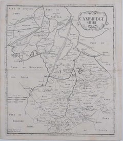
Cambridge map 17th century engraving after John Speed1627
1627
$534.52
£400
€464.01
CA$753.97
A$828.20
CHF 432.82
MX$9,876.98
NOK 5,480.71
SEK 5,105.74
DKK 3,467.33
About the Item
To see more, scroll down to "More from this Seller" and below it click on "See all from this Seller."
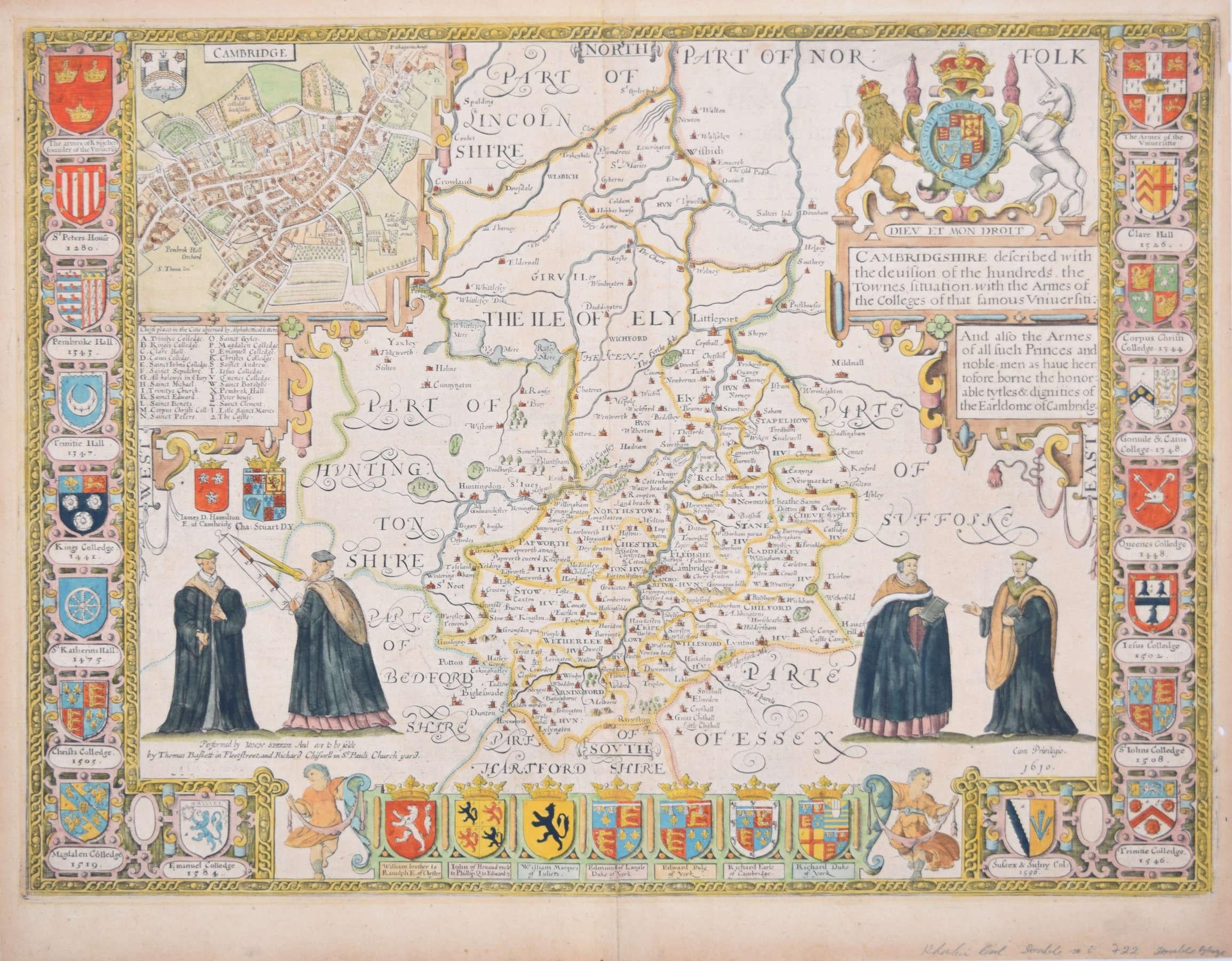
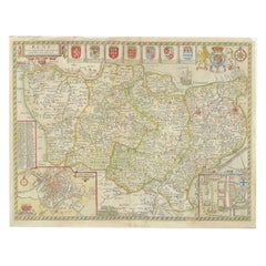
Pieter van den Keere (1571 - circa 1646) after John Speed (1551 or 1552 - 1629)
Map of Cambridgeshire
Engraving
8 x 12 cm
A beautifully coloured map of Cambridgeshire, with an antique description of the county to the reverse. The map, along with many others, was published in Speed's atlas, 'The Theatre of the Empire of Great Britaine', first published in 1611. This particular miniature edition of the 'Theatre' was published in miniature by George Humble in 1627, entitled 'England Wales Scotland and Ireland Described and Abridged With ye Historic Relation of things worthy memory from a farr larger Voulume. Done by John Speed.’ Speed's original map was likely engraved for this edition by Peter van den Keere. van den Keere's maps soon came to be known as "Miniature Speeds".
John Speed was an English cartographer, chronologer and historian. The son of a citizen and Merchant Taylor in London, he rose from his family occupation to accept the task of drawing together and revising the histories, topographies and maps of the Kingdoms of Great Britain as an exposition of the union of their monarchies in the person of King James I and VI. He accomplished this with remarkable success, with the support and assistance of the leading antiquarian scholars of his generation. He drew upon and improved the shire maps of Christopher Saxton, John Norden and others, being the first to incorporate the hundred-boundaries into them, and he was the surveyor and originator of many of the town or city plans inset within them. His work helped to define early modern concepts of British national identity. His Biblical genealogies were also formally associated with the first edition of the King James Bible. He is among the most famous of English mapmakers.
George Humble (1572 - 1640) was an English publisher, known for his publication of John Speed's 'The theatre of the empire of Great Britaine,' the first comprehensive atlas depicting the British Isles, and his later 'A prospect of the most famous parts of the World,' the first English world atlas.
Pieter van den Keere was a Flemish engraver, publisher, and globe maker who worked in England and the Dutch Republic.
Text to reverse reads:
CAMBRIDGE-SHIRE.
CHAPTER XVIII.
CAMBRIDGE-SHIRE, lyeth bounded upon the North with Lincoln shire and North∣folk; upon the East with Northfolk and Suffolk; upon the South with Har•ford•shire and Essex; and upon the West with Bedford and Huntington-shires.
(2) This Province is not large, nor for air greatly to be liked, having the Fens so spread upon her North, that they infect the Air far into the rest: from whose furthest point unto Royston in the South, are thirty five miles, but in the broadest is not fully twenty: the whole in Circumference, traced by the compass of her many indents, one hundred twenty and eight miles.
(3) The Soil doth differ both in Air and Commodities, the Fenny surcharged with waters: the South is Champion, and yieldeth Cor• in abundance, with Meadowing Pastures upon both the sides of the River C•me, which divides that part of the Shire in the midst, upon whose East-bank the Muses have built their most sacred Seat, where with plenteous increase they have continued for these many hundred years.
(4) For from ancient Grantcester, Camboritum by Antonine, now famous Cambridge, the other brest and Nurse-mother of all pious literature, have flowed full streams of the learned Sciences into all other parts of this Land, and else where: ancient indeed, if their story be rightly writ, that will have it built by Cantaber a Spaniard, three hundred seventy five years before the birth of our Saviour, who thither first brought and planted the Muses. This City Grantcester by the tyranny of time lost both her own beauty and her professed Athenian Students, so that in Beda's days, seven hundred years after the word became flesh, it is described to lie a little desolate City, and as yet retaineth the name, without any memory of circuit by walls.
- Creation Year:1627
- Dimensions:Height: 3.15 in (8 cm)Width: 4.73 in (12 cm)
- Medium:
- After:John Speed (1552 - 1629)
- Period:1620-1629
- Framing:Framing Options Available
- Condition:Generally very good; some age toning.
- Gallery Location:London, GB
- Reference Number:1stDibs: LU795311799372
About the Seller
4.8
Vetted Professional Seller
Every seller passes strict standards for authenticity and reliability
Established in 2014
1stDibs seller since 2017
361 sales on 1stDibs
Typical response time: 13 hours
- ShippingRetrieving quote...Shipping from: London, United Kingdom
- Return Policy
More From This Seller
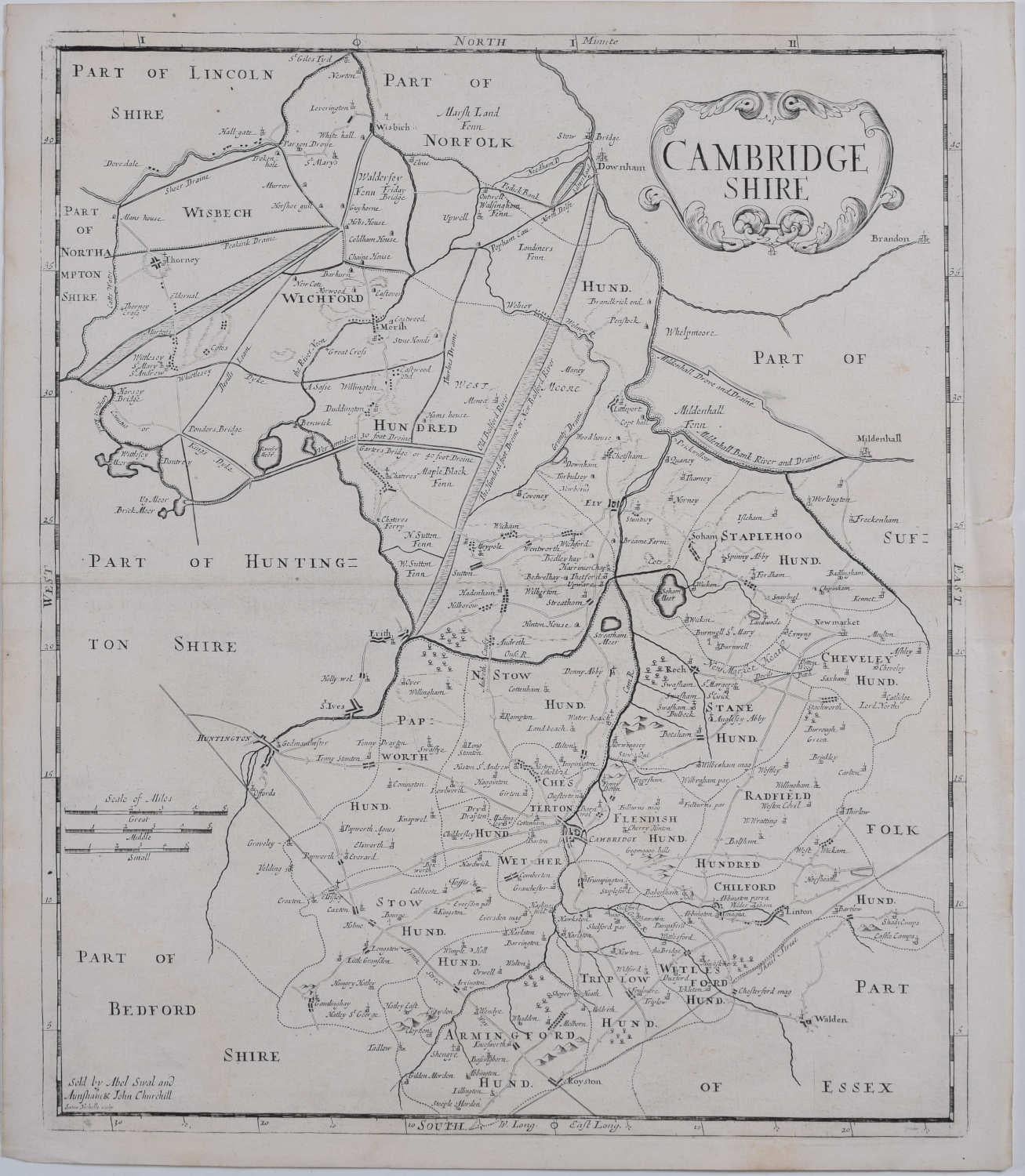
View AllCambridgeshire map 17th century engraving by Kip after Saxton
Located in London, GB
To see more, scroll down to "More from this Seller" and below it click on "See all from this Seller."
William Kip (active 1598 - 1610) after Christopher Saxton (1540 - 1610).
Map o...
Category
1630s Landscape Prints
Materials
Engraving
Cambridgeshire map 17th century engraving by John Speed
By John Speed
Located in London, GB
To see more, scroll down to "More from this Seller" and below it click on "See all from this Seller."
John Speed (1551 or 1552 - 1629)
Map of Cambridgeshire
Engraving with later hand colouring
39 x 53 cm
A beautifully coloured map of Cambridgeshire, with an antique description...
Category
1610s Landscape Prints
Materials
Engraving

Map of Cambridgeshire, 18th century engraving by Sutton Nicholls
Located in London, GB
To see more, scroll down to "More from this Seller" and below it click on "See all from this Seller."
Sutton Nichols (1668 - 1729)
Map of Cambridgeshire
Engraving
43 x 36 cm
Signe...
Category
18th Century Landscape Prints
Materials
Engraving
Map of Cambridge 18th century engraving by Sutton Nichols
Located in London, GB
To see more, scroll down to "More from this Seller" and below it click on "See all from this Seller."
Sutton Nichols (1668 - 1729)
Map of Cambridgeshire
Engraving
43 x 36 cm
Signed in plate lower left.
A beautifully coloured 18th century map engraving of Cambridgeshire. The map was produced by Robert Morden for publication in Edward Gibson's 1695 translation of William Camden's Britannia, a topographical and historical survey of Great Britain and Ireland produced to "restore antiquity to Britaine, and Britain to his antiquity" - a most noble aim.
William Camden (1551 - 1623) was an English antiquarian, historian, topographer, and herald, best known as the author of Britannia, the first chorographical survey of the islands of Great Britain and Ireland, and the Annales, the first detailed historical account of the Queen...
Category
18th Century Landscape Prints
Materials
Engraving
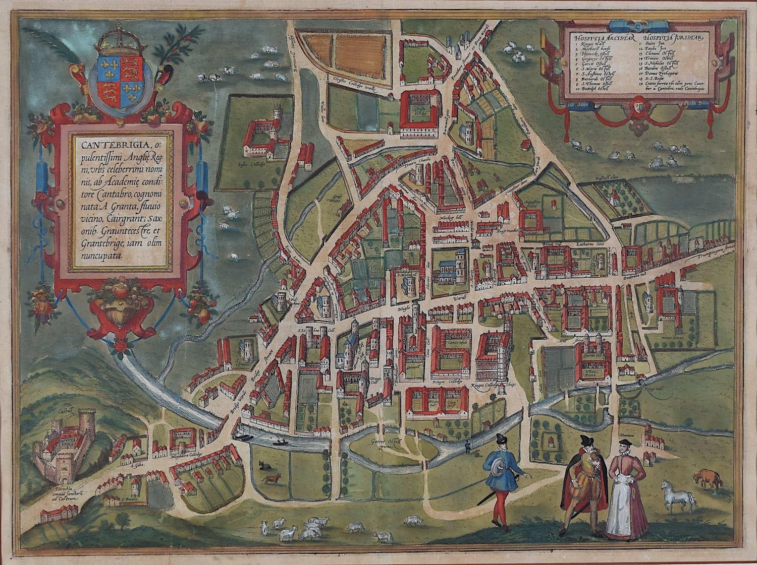
Map of Cambridge, c.1572 engraving by Braun & Hogenberg
Located in London, GB
To see our other views of Oxford and Cambridge, scroll down to "More from this Seller" and below it click on "See all from this Seller" - or send us a message if you cannot find the ...
Category
16th Century Realist Landscape Prints
Materials
Engraving

Map of Cambridge, engraving Pieter van der Aa after David Loggan
By Pieter Van Der Aa
Located in London, GB
Pieter van der Aa (1659 - 1733), after David Loggan (1634 - 1692)
Map of Cambridge
Engraving
12 x 16 cm
An eighteenth-century view of Cambridge, engraved by Pieter van der Aa after ...
Category
Early 18th Century Realist Prints and Multiples
Materials
Engraving

You May Also Like
Antique Map of Hertfordshire in England by Speed, 1627
Located in Langweer, NL
Antique map titled 'Hartfordshire described the sittuations of Hartford (..)'.
Map of Hertfordshire, England. Includes inset maps of Hertford and the Roman settlement of Verolani...
Category
Antique 17th Century Maps
Materials
Paper

Southeastern England: A 17th Century Hand-Colored Map by Mercator and Hondius
By Gerard Mercator
Located in Alamo, CA
A 17th century copperplate hand-colored map entitled "The Sixt Table of England" by Gerard Mercator and Jodocus Hondius, published in Amsterdam in 1635 in 'Cosmographicall Descriptio...
Category
1630s Landscape Prints
Materials
Engraving
Antique Map of Surrey by Speed, 1676
Located in Langweer, NL
Antique map titled 'Surrey described and divided into hundreds'. Map of Surrey, England. Includes inset elevations of Richmond and Nonsuch Palaces. This map originates from 'Theatre ...
Category
Antique 17th Century Maps
Materials
Paper
$459 Sale Price
20% Off
Antique Map of the Northeast of England by Mercator 'circa 1620'
Located in Langweer, NL
Antique map titled 'Eboracum Lincolnia, Derbia, Staffordia, Notinghamia, Lecestria, Rutlandia, et Norfolcia'. Decorative early map of the northeast of England, comprising the countie...
Category
Antique Early 17th Century Maps
Materials
Paper

Antique Map of Kent with Inset Plans of Rochester & Canterbury, England, 1676
Located in Langweer, NL
Antique map titled 'Kent with her Cities and Earles described and observed'.
Map of Kent, England. Includes inset town plans of Rochester and Canterbury....
Category
Antique 17th Century Maps
Materials
Paper
Antique Map of Northamptonshire by Speed, 1676
Located in Langweer, NL
Antique map titled 'Norhamtonshire'. Map of Norhamptonshire, England. Includes inset town plans of Peterborough and Northampton. This map originates from 'Theatre of Great Britaine' ...
Category
Antique 17th Century Maps
Materials
Paper

$517 Sale Price
20% Off
More Ways To Browse
Antique Surveyor
Antique Maps Of Britain
King James I
John Speed Maps
John Speed Antique Maps
Waterloo Anthonie
Axis Mundi
Banksy Walled Off Hotel
Banksy Walled Off
Cartier Poster
Dali Butterfly Suite
David Hockney Red
David Roberts Petra
Earlom Mezzotint
Ernest Roth Etching
Galerie 65 Cannes
Gloucester Etching
Hawaiian Prints Webber