Items Similar to The Life of Shakespeare and Map of Stratford-upon-Avon, lithograph by Kerry Lee

Want more images or videos?
Request additional images or videos from the seller
1 of 9
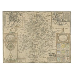
Kerry LeeThe Life of Shakespeare and Map of Stratford-upon-Avon, lithograph by Kerry Lee1965
1965
$947.45
£690
€807.55
CA$1,307.08
A$1,436.84
CHF 755.14
MX$17,448.46
NOK 9,420.14
SEK 8,924.92
DKK 6,026.99
About the Item
To see our other original vintage travel posters, scroll down to "More from this Seller" and below it click on "See all from this seller" - or send us a message if you cannot find the poster you want.
Kerry Lee (1903 - 1988)
Stratford-upon-Avon
Original vintage poster
46 x 60 cm
Published by Pictorial Maps Limited, Kerry Lee's own company
c.1965
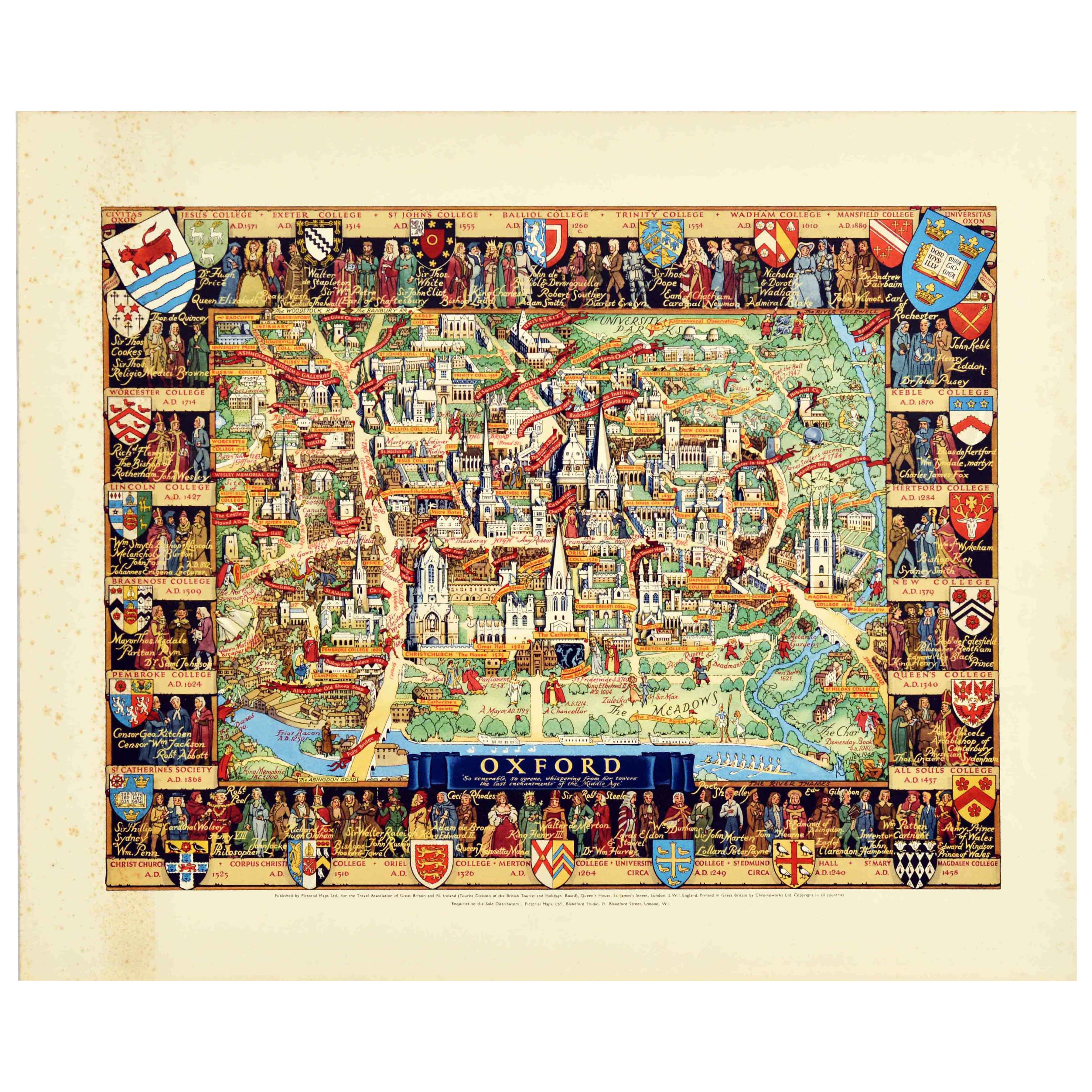
This edition of the map was produced around 1965. It depicts a map of Stratford-upon-Avon with several well known landmarks including the Royal Shakespeare Theatre on the waterfront. As is typical for Lee's maps, however, this map has a unique charm as it not only illustrates the geography of the town, but also the history, recounting the life of Stratford-upon-Avon's most famous export, William Shakespeare. Lee scrawls a chronology of Shakespeare's life over any and every free green space, referring to the playwright affectionately as 'Will.' Lee also frames the map with scenes from Shakespeare's most famous plays, including Romeo and Juliet, The Tempest and Macbeth.
Well known as a creator of pictorial maps of British cities from the mid 20th century, he generally draws a self-portrait in the bottom corner by his signature - as here, where he is seen painting (mustachioed and bearded, and clad in a green tunic) with his ever-faithful dog Jim. Educated at Reading Schools of Arts and Science, the Slade and the Sorbonne in Paris, he subsequently assisted his step-father, an architect named Mr Harvey, as draftsman. Following the Depression Lee set up 'Associated Artists' at Blandford Studios off Baker Street, with a group of other commercial artists.
During World War 2 he was based in Hertfordshire creating detailed cut-away drawings of German aircraft, and after the war - still at Blandford Studios - published a series of pictorial maps, both those for British Rail and also his own publications.
- Creator:
- Creation Year:1965
- Dimensions:Height: 18.12 in (46 cm)Width: 23.63 in (60 cm)
- Medium:
- Movement & Style:
- Period:
- Condition:Generally very good, small tear to the paper.
- Gallery Location:London, GB
- Reference Number:1stDibs: LU795315878312
Kerry Lee
Kerry Lee was educated at Reading Schools of Arts and Science, the Slade and the Paris-Sorbonne University. Lee subsequently assisted his step-father, an architect named Mr. Harvey, as a draftsman. Following the Depression, Lee set up Associated Artists' at Blandford Studios off Baker Street, with a group of other commercial artists. During World War II, he was based in Hertfordshire and created detailed cut-away drawings of German aircraft. After the war, Lee was still at Blandford Studios and published a series of pictorial maps, both those as Travel Posters for British Railways and also as his own publications.
About the Seller
4.8
Vetted Professional Seller
Every seller passes strict standards for authenticity and reliability
Established in 2014
1stDibs seller since 2017
359 sales on 1stDibs
Typical response time: 6 hours
- ShippingRetrieving quote...Shipping from: London, United Kingdom
- Return Policy
Authenticity Guarantee
In the unlikely event there’s an issue with an item’s authenticity, contact us within 1 year for a full refund. DetailsMoney-Back Guarantee
If your item is not as described, is damaged in transit, or does not arrive, contact us within 7 days for a full refund. Details24-Hour Cancellation
You have a 24-hour grace period in which to reconsider your purchase, with no questions asked.Vetted Professional Sellers
Our world-class sellers must adhere to strict standards for service and quality, maintaining the integrity of our listings.Price-Match Guarantee
If you find that a seller listed the same item for a lower price elsewhere, we’ll match it.Trusted Global Delivery
Our best-in-class carrier network provides specialized shipping options worldwide, including custom delivery.More From This Seller
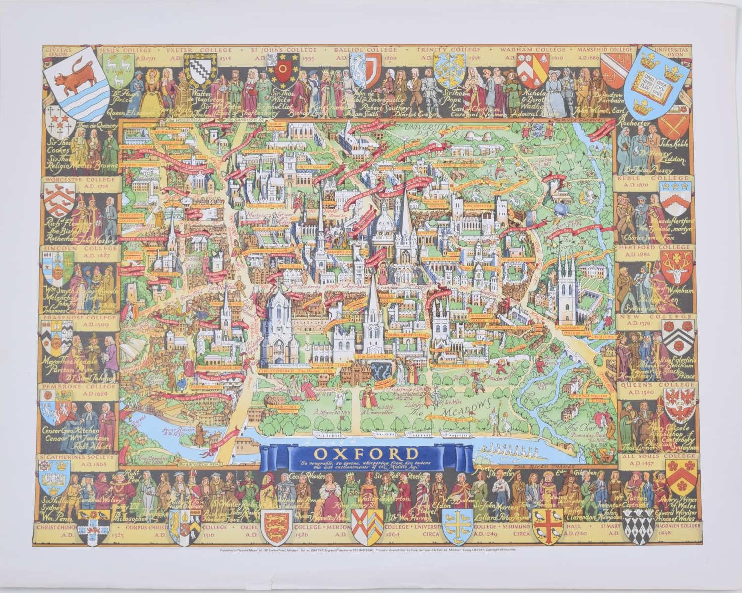
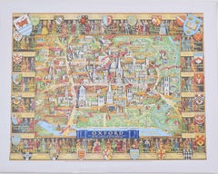
View AllOxford, original vintage map by Kerry Lee
By Kerry Lee
Located in London, GB
To see our other original vintage travel posters, scroll down to "More from this Seller" and below it click on "See all from this seller" - or send us a message if you cannot find th...
Category
1960s Realist Landscape Prints
Materials
Lithograph
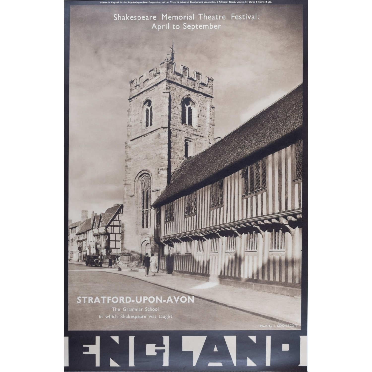
Stratford-upon-Avon, vintage 1950s travel poster by J. Dixon Scott
Located in London, GB
John Dixon Scott
Stratford-upon-Avon
76 x 51 cm
Lithograph
Published by the Travel Association of Great Britain and N.Ireland this beautiful photographic image encouraged travel to ...
Category
1950s Photorealist Figurative Prints
Materials
Lithograph

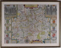
John Speede, Map of the County of Surrey, described and divided into hundreds
By John Speed
Located in London, GB
To see our other views and maps of England - including London, Oxford and Cambridge, scroll down to "More from this Seller" and below it click on "See all from this Seller" - or send us a message if you cannot find the view you want.
John Speed/Speede (1551/2-1629)
The County of Surrey Described and Divided into Hundreds
Engraving with later hand colouring and text to the reverse.
Dated to c.1650
36 x 49 cm
Probably the most famous early English mapmaker, John Speed's early life is somewhat of an enigma. He is believed to have trained as a rolling-press printer, but he was at heart an historian granted a sinecure in the Customs House by Queen Elizabeth to indulge his passion, later becoming a Fellow of the Society of Antiquaries. His first maps were historical, of the Holy Land 'Canaan as it was Possessed both in Abraham and Israels Dayes' and of England and Ireland recording 'all their Civill Warres since the Conquest'.
In 1611 he published his 'Hostory of Great Britaine' which he regarded as his magnum opus, but it was the companion atlas 'Theatre of the Empire of Great Britaine' that - as the first printed atlas of Great Britain - sealed his reputation. William Rogers engraved the first map, 'the County Palatine of Chester' in about 1600, but following his untimely death the task of engraving was passed to Jodocus Hondius of Amsterdam.
By 1612 the atlas was complete, the maps famed for their decorative elements. Many have town plans - Britain's first series of such plans - and descriptive text was printed to the reverse until the 1676 edition. Later printings (up until 1770) were issued without this text. By 1627 it has become a part of a world atlas 'Prospect of the Most Famous Parts of the World'. During the 17th century the plates passed through the hands of a series of publishers, the 1676 edition of Thomas Bassett and Richard Chiswell being regarded as its high point with the inclusion for the first time of a series of important maps. For the first half of the eighteenth century they were firmly established in the hands of the Overton family.
This particular edition originally featured in The Theatre Of The Empire Of Great Britaine. It features attractive inset views of the long-since destroyed Richmond...
Category
17th Century Realist Landscape Prints
Materials
Engraving
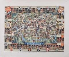
Cambridge Map, Original Vintage Poster by Kerry Lee
By Kerry Lee
Located in London, GB
To see our other original vintage travel posters, scroll down to "More from this Seller" and below it click on "See all from this seller" - or send us a message if you cannot find th...
Category
1940s Realist Landscape Prints
Materials
Lithograph
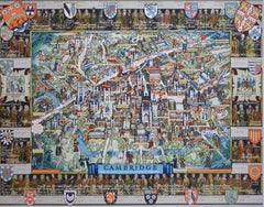
Cambridge map original vintage poster by Kerry Lee
By Kerry Lee
Located in London, GB
To see our other original vintage travel posters, scroll down to "More from this Seller" and below it click on "See all from this seller" - or send us a message if you cannot find the poster you want.
Kerry Lee (1903 - 1988)
Cambridge
Original vintage poster
45 x 58 cm
A detailed and brightly-coloured map of Dublin...
Category
1940s Realist Landscape Prints
Materials
Lithograph
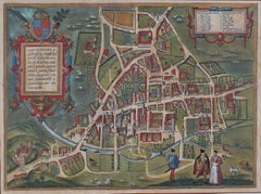
Map of Cambridge, c.1572 engraving by Braun & Hogenberg
Located in London, GB
To see our other views of Oxford and Cambridge, scroll down to "More from this Seller" and below it click on "See all from this Seller" - or send us a message if you cannot find the ...
Category
16th Century Realist Landscape Prints
Materials
Engraving
You May Also Like
Original Vintage Travel Advertising Poster Oxford Pictorial Map Kerry Lee UK
By Kerry Lee
Located in London, GB
Original vintage travel advertising poster featuring a pictorial map of Oxford with the title on a blue ribbon - Oxford 'So venerable, so serene, whisper...
Category
Vintage 1940s British Posters
Materials
Paper

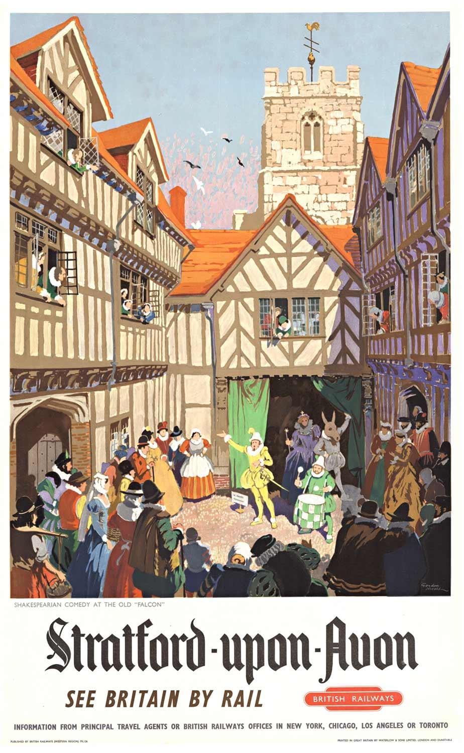
Original "Stratford-upon-Avon" vintage British Railways poster
By Gordon Nicoll
Located in Spokane, WA
Original Stratford Upon Avon vintage poster. British Railways,
Artist: Gordon Nicoll Archival linen backed and in fine condition, ready to...
Category
1950s American Modern Figurative Prints
Materials
Lithograph

$1,680 Sale Price
20% Off
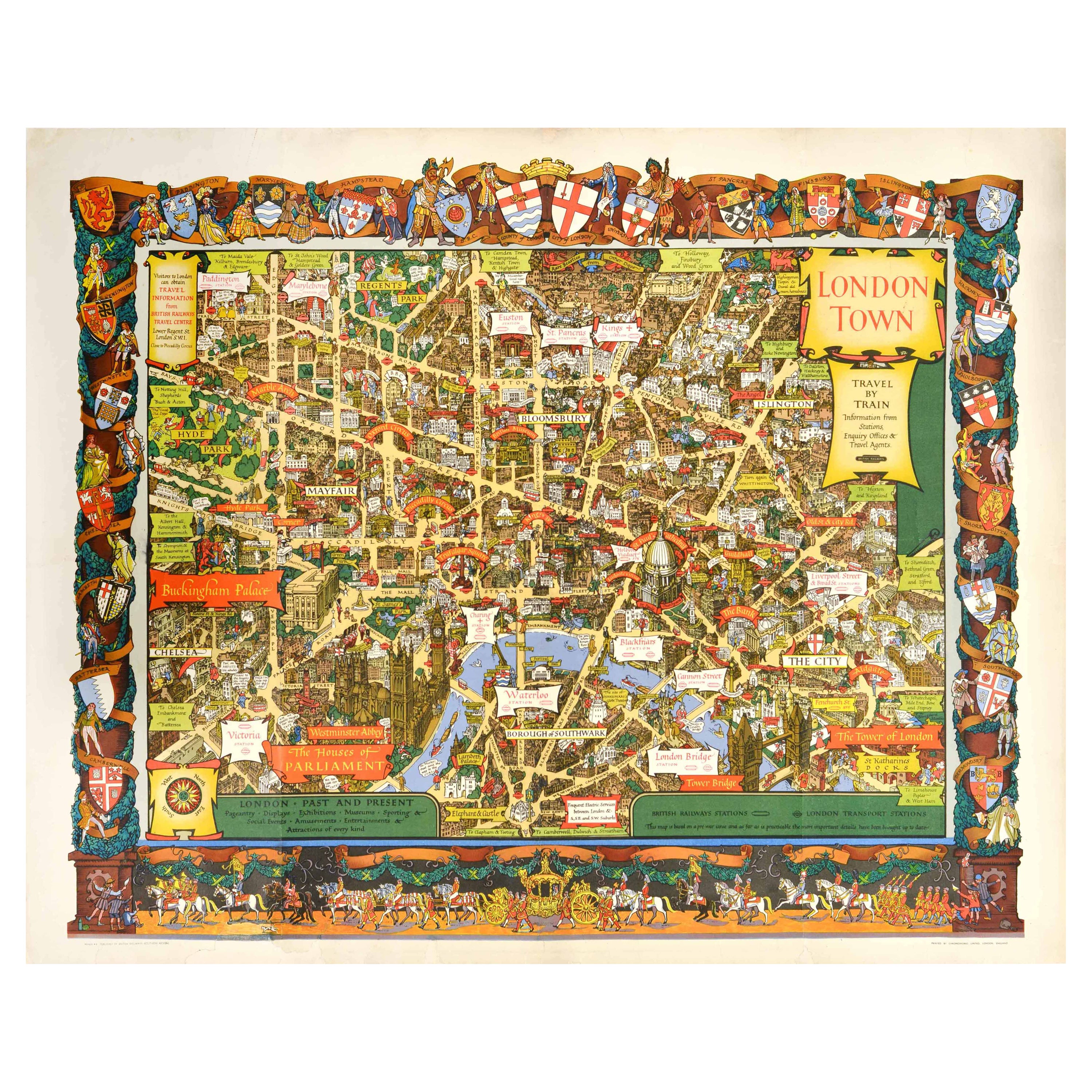
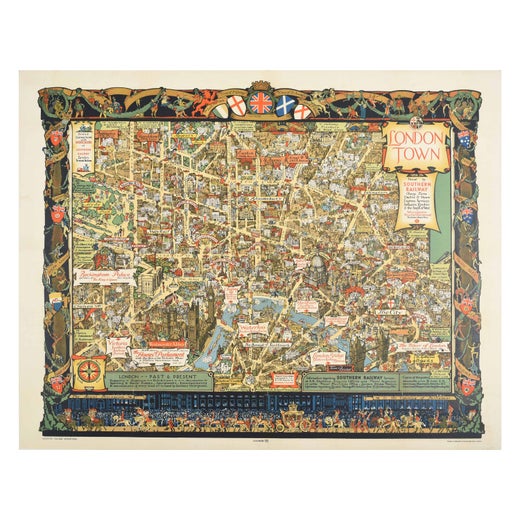
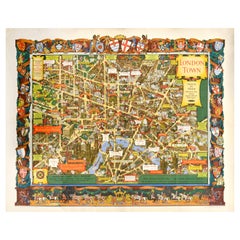
Original Vintage Travel By Train London Town Pictorial Map Poster Kerry Lee
By Kerry Lee
Located in London, GB
Original vintage Travel By Train map poster for London Town by the British artist, illustrator and poster designer Kerry Lee (1902-1988) featuring a detailed...
Category
Vintage 1950s British Posters
Materials
Paper
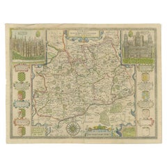
Antique Map of Warwickshire by Speed, c.1614
Located in Langweer, NL
Antique map titled 'The Counti of Warwick (..)'. Map of Warwickshire, England. Includes inset town plans of Warwick and Coventry. This map originates from 'Theatre of Great Britaine'...
Category
Antique 17th Century Maps
Materials
Paper
$449 Sale Price
20% Off
1952 Statford-Upon-Avon, British Railways Original Vintage Poster
Located in Winchester, GB
This beautiful & rare poster was created in 1952, advertising British Railways routes to Stratford-upon-Avon in Warwickshire, England. With vibrant artwork by Gordon William Nicoll (...
Category
Vintage 1950s British Posters
Materials
Linen, Paper
$1,812 Sale Price
20% Off
Free Shipping
Antique Map of Surrey by Speed, 1676
Located in Langweer, NL
Antique map titled 'Surrey described and divided into hundreds'. Map of Surrey, England. Includes inset elevations of Richmond and Nonsuch Palaces. This map originates from 'Theatre ...
Category
Antique 17th Century Maps
Materials
Paper
$468 Sale Price
20% Off