Items Similar to Union Pacific West vintage fun map railroad travel poster

Want more images or videos?
Request additional images or videos from the seller
1 of 9
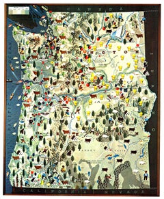
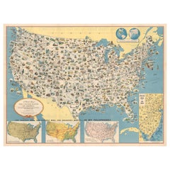
Union Pacific West vintage fun map railroad travel poster1966
1966
$249
£188.66
€216.48
CA$350.38
A$385.17
CHF 202.43
MX$4,677.34
NOK 2,525.22
SEK 2,392.47
DKK 1,615.63
About the Item
Original “The Union Pacific West fun map, archivally linen backed in very good condition. Ready to frame. This was initially folded, and the fold marks were mitigated during linen backing.
Note that the backside of the poster has more information about the destination but is covered by the linen backing.
Embark on an exciting journey through the heartland of America with our Union Pacific West Fun Map! This unique and captivating map showcases the Midwest states from Kansas to California, providing a delightful visual representation of Union Pacific routes. While not to scale, this map is designed for adventure, highlighting key features and attractions in each state along the way.
• Detailed Representation: Explore the charm of the Midwest with an intricately illustrated map that brings the region to life. From the plains of Kansas to the scenic beauty of California, each state is portrayed with attention to detail.
• Union Pacific Routes: Follow the iconic Union Pacific routes that crisscross the landscape, connecting communities and offering a glimpse into the rich history of rail travel.
• State-Specific Features: Dive into the unique attractions of each state with carefully curated images showcasing landmarks, natural wonders, and points of interest. Whether it's the Grand Canyon in Arizona or the iconic arch in St. Louis, each state has its own story to tell.
• Not to Scale, All for Fun: While the map is not to scale, it's intentionally crafted to be a fun and engaging exploration of the region. Perfect for enthusiasts, travelers, and anyone with a sense of adventure.
Whether you're a railroad enthusiast, a geography buff, or someone planning a road trip through the Midwest, this map is a delightful addition to your collection. Uncover the magic of the Union Pacific West and each state's diverse wonders.
This is an Original Lithograph Vintage Poster; it is not a reproduction.
#UnionPacificRailroad
- Attributed to:Rigby
- Creation Year:1966
- Dimensions:Height: 18 in (45.72 cm)Width: 23.75 in (60.33 cm)Depth: 0.05 in (1.27 mm)
- Medium:
- Movement & Style:
- Period:
- Condition:Original vintage poster in excellent condition with archival linen backing, ready to frame. Certificate of Authenticity with an embedded image of the poster.
- Gallery Location:Spokane, WA
- Reference Number:Seller: 240031stDibs: LU1404213772362
About the Seller
5.0
Platinum Seller
Premium sellers with a 4.7+ rating and 24-hour response times
Established in 1998
1stDibs seller since 2020
248 sales on 1stDibs
Typical response time: <1 hour
- ShippingRetrieving quote...Shipping from: Spokane, WA
- Return Policy
Authenticity Guarantee
In the unlikely event there’s an issue with an item’s authenticity, contact us within 1 year for a full refund. DetailsMoney-Back Guarantee
If your item is not as described, is damaged in transit, or does not arrive, contact us within 7 days for a full refund. Details24-Hour Cancellation
You have a 24-hour grace period in which to reconsider your purchase, with no questions asked.Vetted Professional Sellers
Our world-class sellers must adhere to strict standards for service and quality, maintaining the integrity of our listings.Price-Match Guarantee
If you find that a seller listed the same item for a lower price elsewhere, we’ll match it.Trusted Global Delivery
Our best-in-class carrier network provides specialized shipping options worldwide, including custom delivery.More From This Seller
View AllOriginal 'Map of the United States as Californians See It' vintage map poster
Located in Spokane, WA
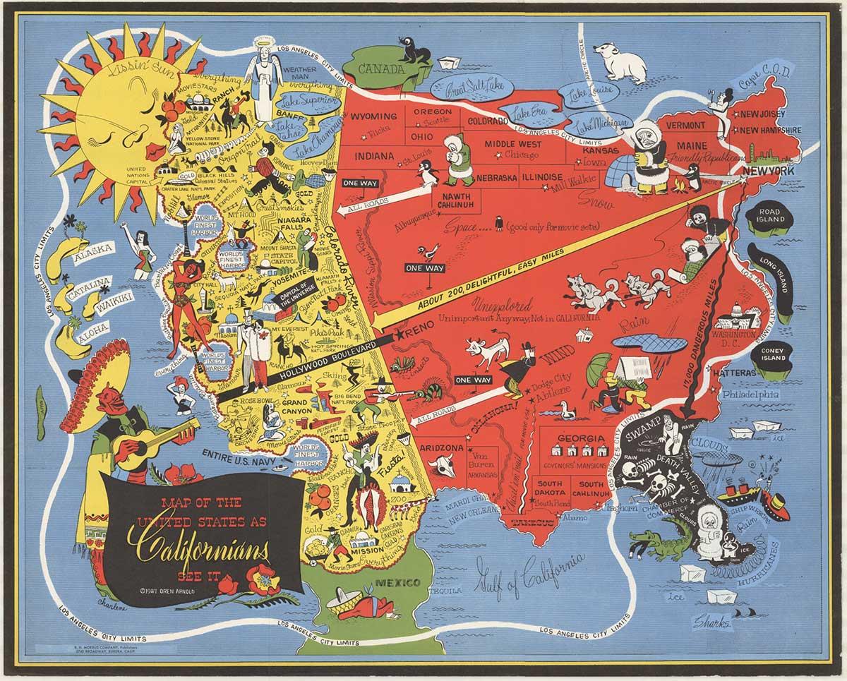
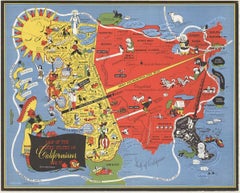
Original vintage poster: "Map of the United States as Californians See It". 1947, artist: Oren Arnold. Size: 16.5" x 20.5", R. H. MOEBUS COMPANY This poster is not linen-backed. This poster is in very good fine condition, ready to frame.
A humorous satirical pictorial map from 1947 with the golden sun on the upper left, gives a detailed depiction of California, its relative size to the rest of the United States, showing Florida as "Death Valley", the rest of the United States as "Unexplored" 'Unimportant anyway, not in California". The image has your Mexican singer; bikini-clad bathers and others set in the image. Shows rivers, lakes, harbors, landmarks, parks, recreational activities, and local people.
This map shows Los Angeles’ city...
Category
1940s American Modern Landscape Prints
Materials
Offset
$1,280 Sale Price
20% Off
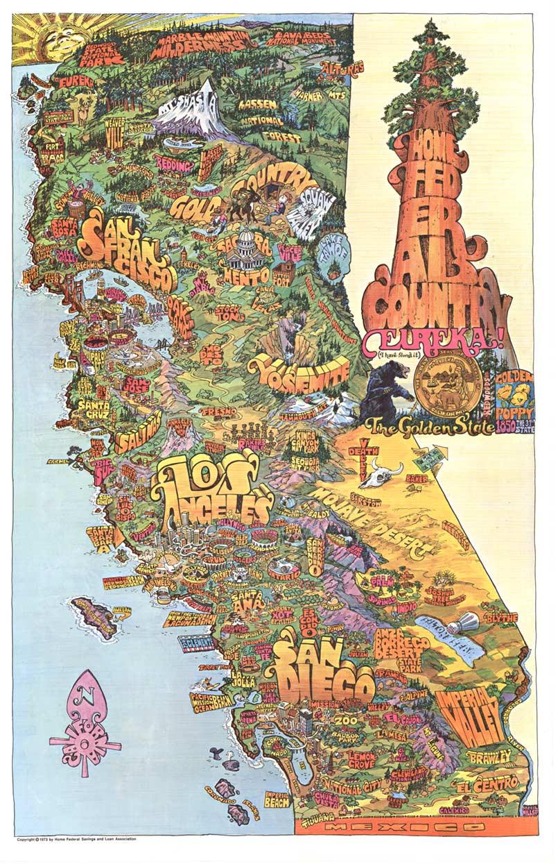
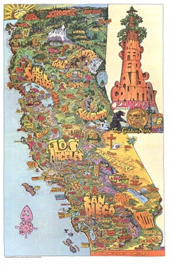
Original Southern California Home Federal Fun Map vintage poster
Located in Spokane, WA
Original California Fun Map vintage poster from 1973. Archival linen backed in fine condition that is ready to frame.
Artist: Darrel Millsap.
This fun map...
Category
1970s American Modern Landscape Prints
Materials
Offset
$559 Sale Price
20% Off
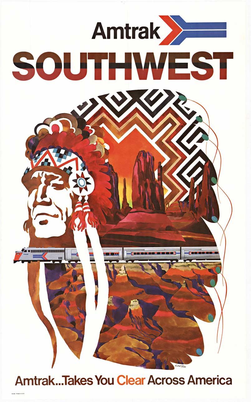
Original Southwest Amtrak vintage American travel by train vintage poster
By David Klein
Located in Spokane, WA
Original Amtrak Southwest Amtrak … Takes You Clear Across America vintage travel poster. Amtrack … Takes You Clear Across America tr...
Category
1970s American Modern Landscape Prints
Materials
Offset

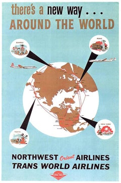
Original Northwest Orient and Trans World Airlines vintage travel poster
Located in Spokane, WA
Original poster: NORTHWEST ORIENT AIRLINES, TRANS WORLD AIRLINES poster. Description
There’s a New Way Around the World / Northwest Orient Airlines – Trans World Airlines. Circa 1...
Category
1950s American Modern Landscape Prints
Materials
Lithograph
Original 1940 Washington & Oregon Pictorial Map vintage poster
Located in Spokane, WA
Map of historical landmarks, American Indian territories, rivers, mountains, dams, colleges, federal grazing districts, cities, agriculture, and other activities that were present in...
Category
1940s American Realist Landscape Prints
Materials
Offset
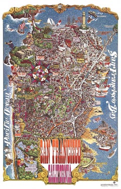
Original San Francisco, California vintage fun map poster Henry Hinton
Located in Spokane, WA
Original San Francisco, California fun map vintage poster 1970. Archival linen backed in very fine condition, ready to frame.
-Artist: Henry Hinton
I don’t know how much more you could include in this detailed fun map of San Francisco...
Category
1970s American Impressionist Landscape Prints
Materials
Offset
You May Also Like
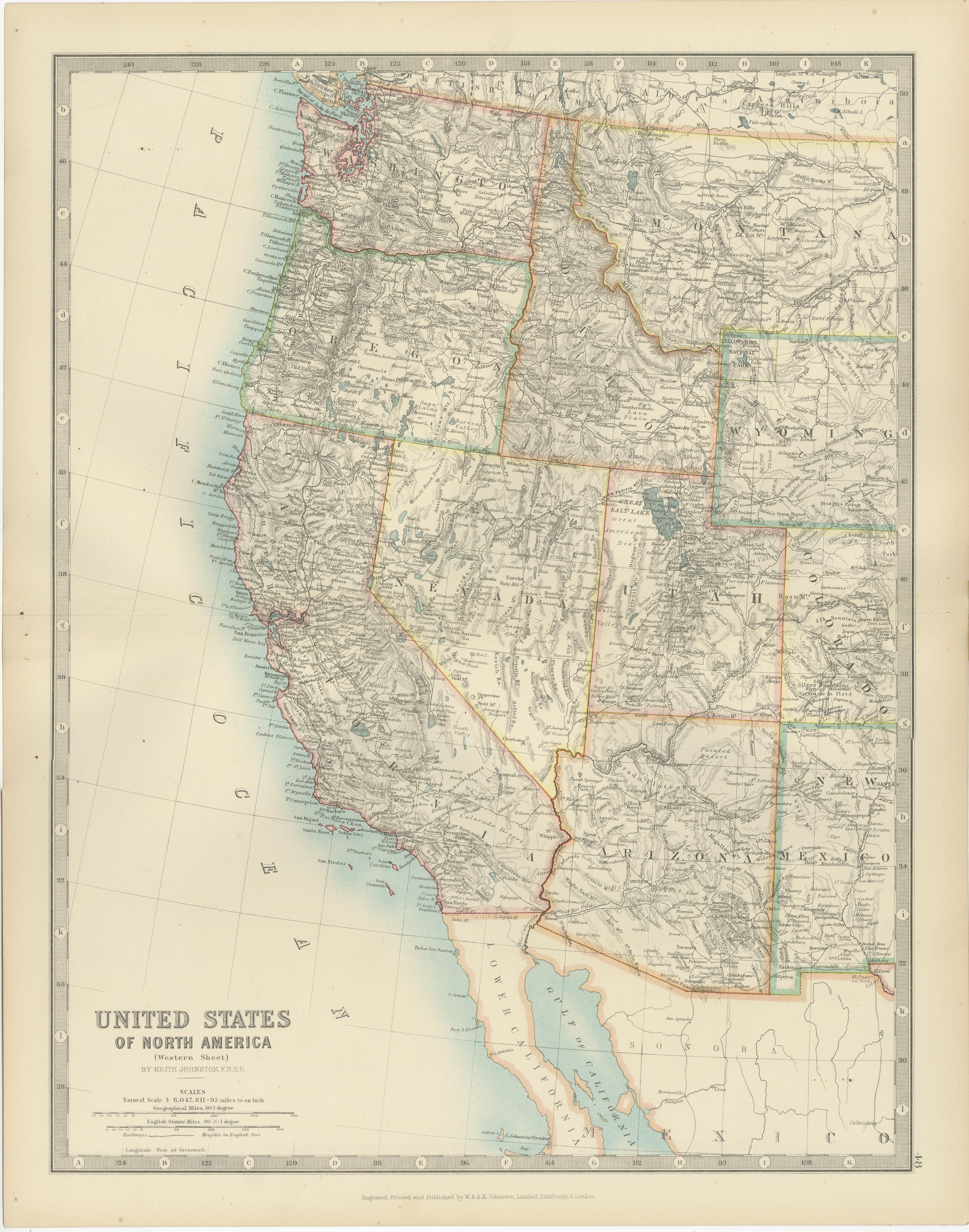
Map of Western United States 1903 – Railroads, State Borders, and Terrain
Located in Langweer, NL
Map of Western United States 1903 – Railroads, State Borders, and Terrain
This beautifully engraved map titled "United States of North America (Western Sheet)" was created by Keith ...
Category
Early 20th Century Maps
Materials
Paper

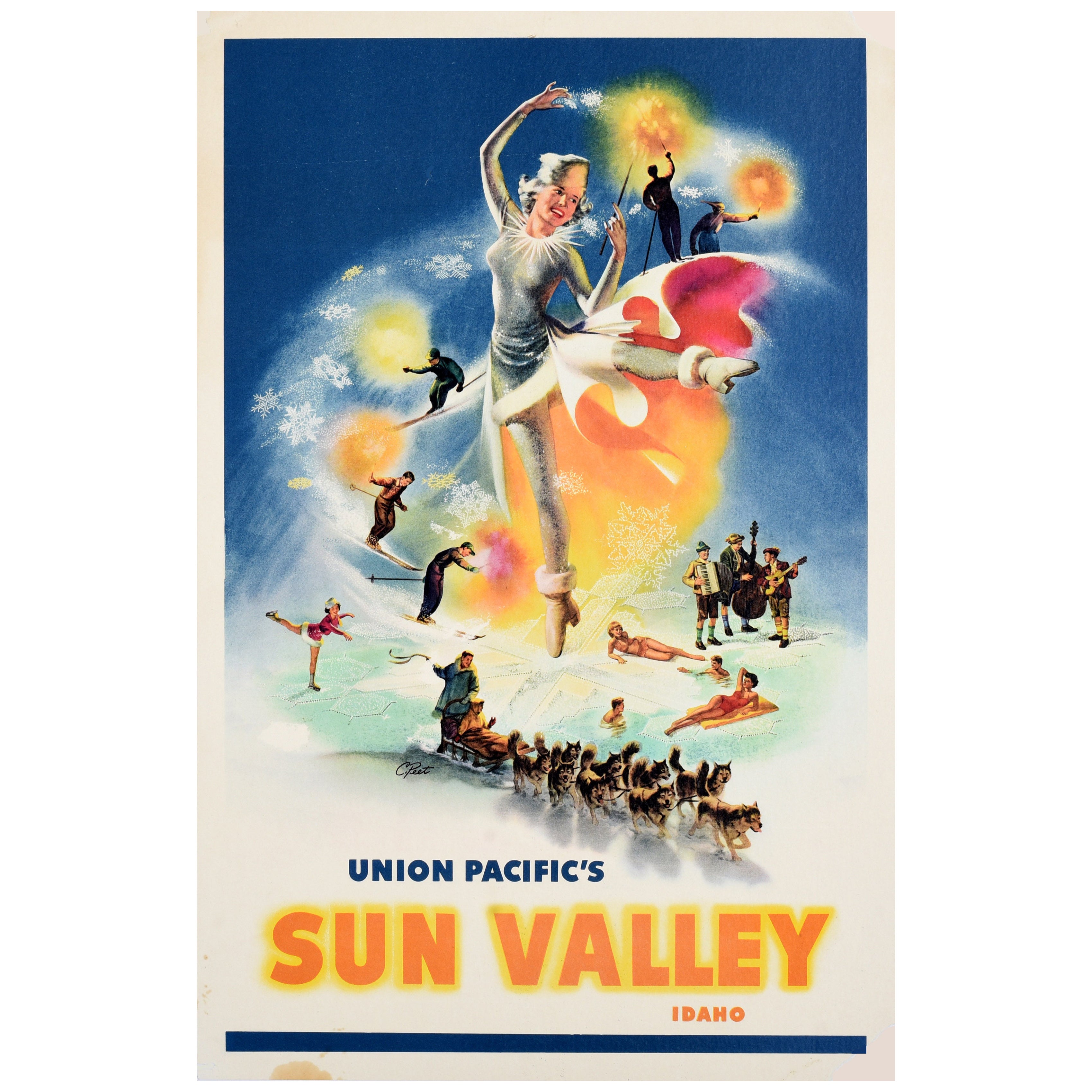
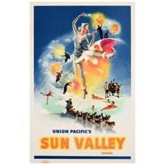
Original Vintage Travel Poster Union Pacific Railway Sun Valley Idaho Ski USA
Located in London, GB
Original vintage winter sport and ski travel poster - Union Pacific's Sun Valley Idaho - featuring illustrations of a smiling lady as an ice maiden wearing a sparkling dress with a f...
Category
Vintage 1950s American Posters
Materials
Paper
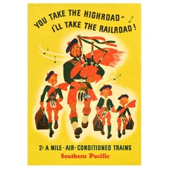
Original Vintage Travel Poster Southern Pacific Scotsman USA Railroad Highroad
Located in London, GB
Original vintage travel advertising poster - You take the highroad I'll take the railroad! 2c a mile air conditioned trains Southern Pacific - featuring a fun and colourful illustrat...
Category
Vintage 1930s American Posters
Materials
Paper
Antique Railroad Map of the United States by Rand, McNally & Co, 1900
Located in Langweer, NL
Antique map titled 'Rand, McNally & Co's New Official Railroad map of the United States with portions of The Dominion of Canada, The Republic of Mexico and the West Indies'. Large railroad map of the United States, sectionalised and laid on linen. Map shows state boundaries for the United States, Mexico, the West Indies, and lower portion of Canada; major cities and towns, military posts, Native American reservations, and railroads; Oklahoma and "Indian Territory." Inset: "Map of Alaska...
Category
20th Century Maps
Materials
Linen, Paper

$2,243 Sale Price
25% Off
Free Shipping
Old Decorative Pictorial Map of the United States, circa 1953
Located in Langweer, NL
Antique map titled 'A Pictorial Map of the United States of America Showing Principal Regional Resources, Products, and Natural Features'.
This information-packed map was create by the General Drafting Company for the New Jersey Bell Telephone Company. The main map features over 700 drawings in full color including points of interest, natural resources, and agricultural products. At bottom are inset maps showing railroad lines, air routes, telephone lines, as well as a pictorial map of New Jersey...
Category
20th Century Maps
Materials
Paper
$718 Sale Price
20% Off
1950 Santa Fe Railway, San Francisco Original Vintage Poster
Located in Winchester, GB
Stunning poster for the Santa Fe Railway promoting routes to San Francisco, California. Founded in 1859, the Santa Fe Railway, full name Atchison, Top...
Category
Vintage 1950s American Posters
Materials
Paper
More Ways To Browse
Vintage Illustrated Maps
Vintage Grand Canyon Travel Posters
Charon Lithograph
Childe Hassam Etching
Christo Running Fence
Christo Surrounded Islands
Christo Wrapped Trees
Eyvind Earle Serigraph
Fairfield Porter Lithograph
Grant Wood Lithographs
Harold Altman Luxembourg
Hassam Etching
Joichi Hoshi Woodblock Prints
Joseph Friebert
Kahn Scott
Lahaina Harbor
Marco Pierre
Mark Coomer