Items Similar to 20th century color lithograph poster landscape pastoral building hills signed


Want more images or videos?
Request additional images or videos from the seller
1 of 10
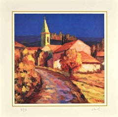
Vecoux20th century color lithograph poster landscape pastoral building hills signed1946
1946
$5,220
£3,955.14
€4,538.21
CA$7,345.38
A$8,074.60
CHF 4,243.64
MX$98,055.01
NOK 52,938.31
SEK 50,155.33
DKK 33,869.81
About the Item
"Cote Basque" is an original lithograph of the Basque region of France created by Vecoux for the Societe Nationale des Chemis de fer Francais, the French National Railways.
24" x 39" paper
31 3/8" x 22" image
31 3/8" x 22" frame
The SNCF, the French National Rail system, commissioned multiple posters to advertise and celebrate the connected locations on their routes after the Second World War. "Cote Basque", created by Vecoux, uses bright and inviting colors to showcase the beauty of the French coast. This scene is in stark contrast to the destruction that the war had wrought in this area during the 1944 invasion. Because of this, the set of posters would have reinforced the public's hope in a peaceful and beautiful France.
Printed in France for and by French National Railways; Publicite S.N.C.F.; No. 41-6, R.C. Seine No. 276.448B; Editions Paul Martial-Paris
- Creator:
- Creation Year:1946
- Dimensions:Height: 24 in (60.96 cm)Width: 39 in (99.06 cm)
- Medium:
- Movement & Style:
- Period:
- Condition:Minor folds in right margin.
- Gallery Location:Milwaukee, WI
- Reference Number:Seller: 13784g1stDibs: LU60531935693
About the Seller
4.9
Platinum Seller
Premium sellers with a 4.7+ rating and 24-hour response times
Established in 1966
1stDibs seller since 2017
447 sales on 1stDibs
Typical response time: 3 hours
- ShippingRetrieving quote...Shipping from: Milwaukee, WI
- Return Policy
Authenticity Guarantee
In the unlikely event there’s an issue with an item’s authenticity, contact us within 1 year for a full refund. DetailsMoney-Back Guarantee
If your item is not as described, is damaged in transit, or does not arrive, contact us within 7 days for a full refund. Details24-Hour Cancellation
You have a 24-hour grace period in which to reconsider your purchase, with no questions asked.Vetted Professional Sellers
Our world-class sellers must adhere to strict standards for service and quality, maintaining the integrity of our listings.Price-Match Guarantee
If you find that a seller listed the same item for a lower price elsewhere, we’ll match it.Trusted Global Delivery
Our best-in-class carrier network provides specialized shipping options worldwide, including custom delivery.More From This Seller
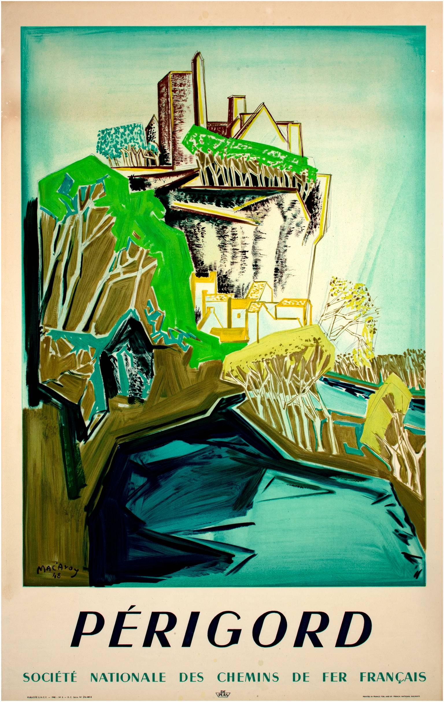
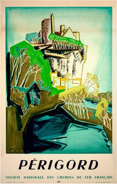
View AllEarly 20th century color lithograph poster mountain building trees sky text
By Edouard-Georges Mac-Avoy 1
Located in Milwaukee, WI
"Perigord" is an original lithograph of a landscape created for the Societe Nationale des Chemis de fer Francais, the French National Railways. Artist Eduoard Georges Mac'Avoy worked...
Category
1940s Landscape Prints
Materials
Lithograph
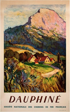
Early 20th century color lithograph poster mountain field houses trees sky text
By Paul Kelsch
Located in Milwaukee, WI
"Dauphine" is an offset lithograph of a pastoral landscape created by Paul Kelsch for the Societe Nationale des Chemis de fer Francais, the French National Railways.
24" x 39" paper
30 1/2" x 21 1/8" image
48" x 33" frame
Small hole in each corner, crease in paper and image upper left, small holes lower left.
The SNCF, the French National Rail system, commissioned multiple posters to advertise and celebrate the connected locations on their routes after the Second World War. "Dauphine", created by Paul Kelsch, showcases a small village at the foot of a mountain bathed in the light of a sunset. Kelsch's technique employed impasto brush strokes and bright colors to capture the beauty of the landscape. This scene is in stark contrast to the destruction that the war had wrought in this area during the 1944 invasion. Because of this, the set of posters...
Category
1940s Other Art Style Landscape Prints
Materials
Lithograph
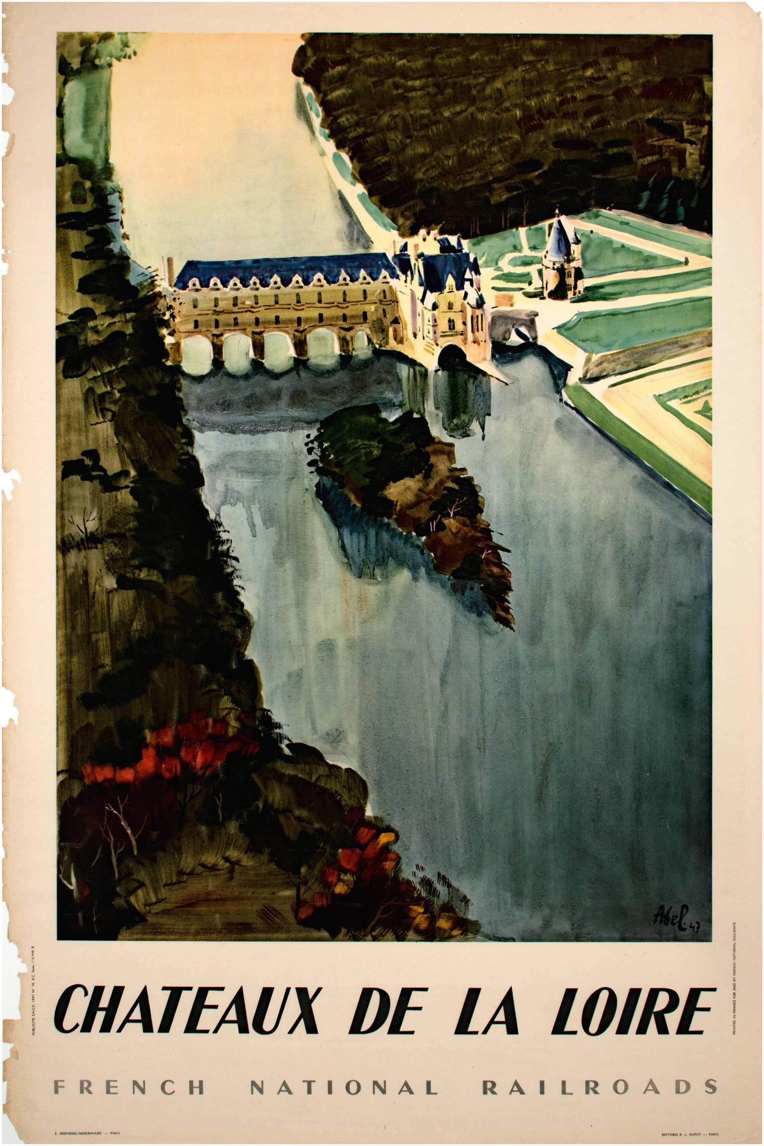
Early 20th century color lithograph poster river building trees text
By Robert Abel
Located in Milwaukee, WI
"Chateaux De La Loire" is a signed original lithograph by Robert Abel. It depicts a view of one of the most iconic houses on the Loire River in France.
Left ...
Category
21st Century and Contemporary Landscape Prints
Materials
Lithograph

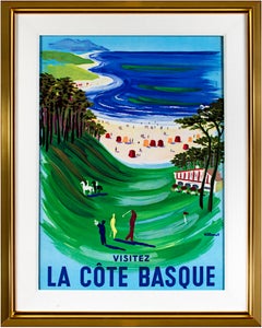
'La Côte Basque' original lithograph travel poster with beach and golf
By Bernard Villemot
Located in Milwaukee, WI
This poster, titled 'La Côte Basque' in the image, was intended to draw people to travel to the Basque coast of Spain. The image is dominated by the serene blues, greens and yellows of the golf course and sandy beach. Throughout the vista, figures can be seen at leisure golfing, riding horseback, eating at restaurants, and sunbathing.
34 x 23.75 inches, poster
43.5 x 33.25 inches, image
Signed in the stone, lower right
Framed to conservation standards using archival materials including 100 percent rag mounting, UV5 Plexiglas to inhibit fading, and housed in a gold finished wood moulding with a 3-inch Belgian linen liner.
Bernard Villemot (1911 – 1989) was a French graphic artist known primarily for his iconic advertising images for Orangina, Bally Shoe, Perrier, and Air France. He was known for a sharp artistic vision that was influenced by photography, and for his ability to distill an advertising message to a memorable image with simple, elegant lines and bold colors. From 1932 to1934, he studied in Paris with artist Paul Colin, who was considered a master of Art Deco. From 1945 to 1946, Villemot prepared posters for the Red Cross. In the late 1940s, he also began a famous series of travel posters for Air France that would continue for decades. In 1949, Villemot's works were exhibited with those of his contemporary poster artist Raymond Savignac at the Gallery of Beaux Arts in Paris. In 1953, Villemot began designing logos and posters for the new soft drink Orangina, and over time these works would become some of his best known. In 1963, the Museum of Decorative Arts in Paris held an exhibition of his works. By the end of his life in 1989, he was known as one of the last great poster artists, and many collectors and critics consider him to be the "painter-laureate of modern commercial art." Since his death in 1989, his memorable images have been increasingly sought after by collectors. At least three books have been published that survey his art: "Les affiches de Villemot," by Jean-Francois Bazin...
Category
1960s Modern Landscape Prints
Materials
Lithograph
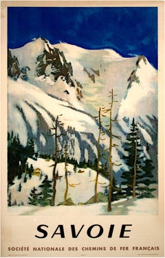
"Savoie (Societe National des Chemins de Fer Francais), " by L.J. Fontanarosa
By Lucien Joseph Fontanarosa
Located in Milwaukee, WI
"Savoie (Societe National des Chemins de fer Francais)" is a signed offset lithograph of a pastoral landscape created for the Societe Nationale...
Category
1940s Other Art Style Landscape Prints
Materials
Lithograph
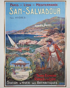
"San Salvador: Station d'Hiver des Arthritiques" Original Color Lithograph
By Ernest-Louis Lessieux
Located in Milwaukee, WI
"San Salvador (Mediterranean)" is an original color lithograph poster by Ernest Louis Lessieux. It depicts a woman and her son on the picturesque coast of...
Category
Late 19th Century Landscape Prints
Materials
Lithograph, Color
You May Also Like
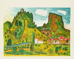
Landscape - Offset and Lithograph by Unknown Master Late 20th Century
Located in Roma, IT
Landscape is an original print on paper realized by an Anonymous artist of XX century.
In good condition except for some foxes that shows the trace of time.
Sheet dimension:44.5 x 52 cm
The artwork represents a beautiful scenery of a village down below the green mountain, dream-like peaceful village with red roof houses beside the yellow road.
Category
Late 20th Century Landscape Prints
Materials
Lithograph, Offset
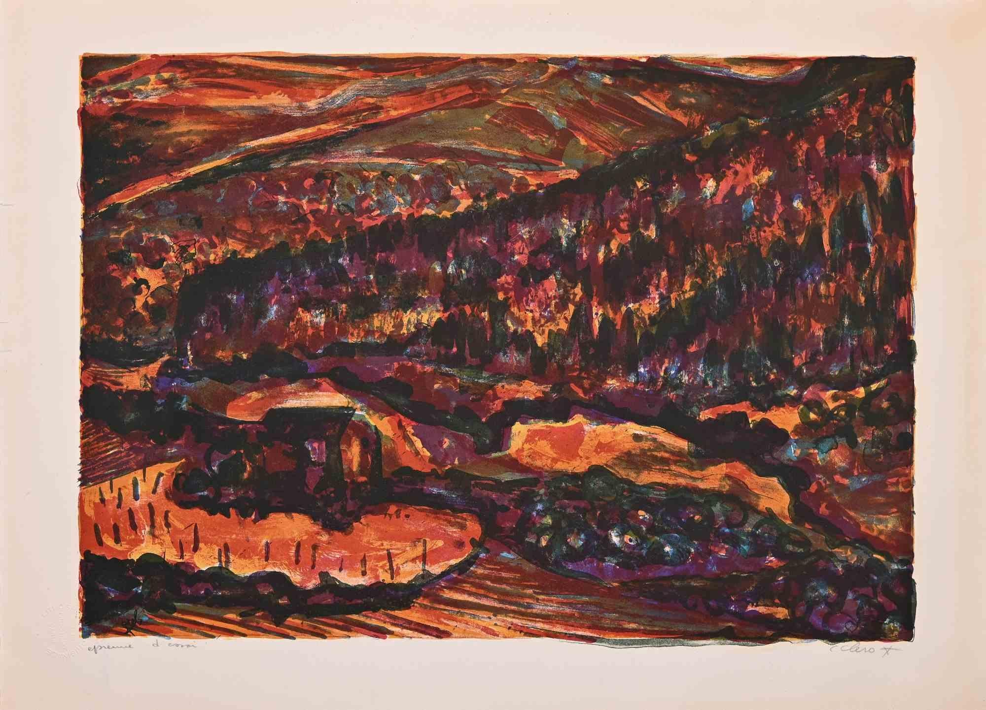
Landscape - Lithograph attr. to Claude Clero - Mid-20th century
Located in Roma, IT
Landscape is an original lithograph realized by Claude Clero (attributed).
Good condition.
Proof artist, hand signed with pencil by the artist.
Category
20th Century Contemporary Abstract Prints
Materials
Lithograph
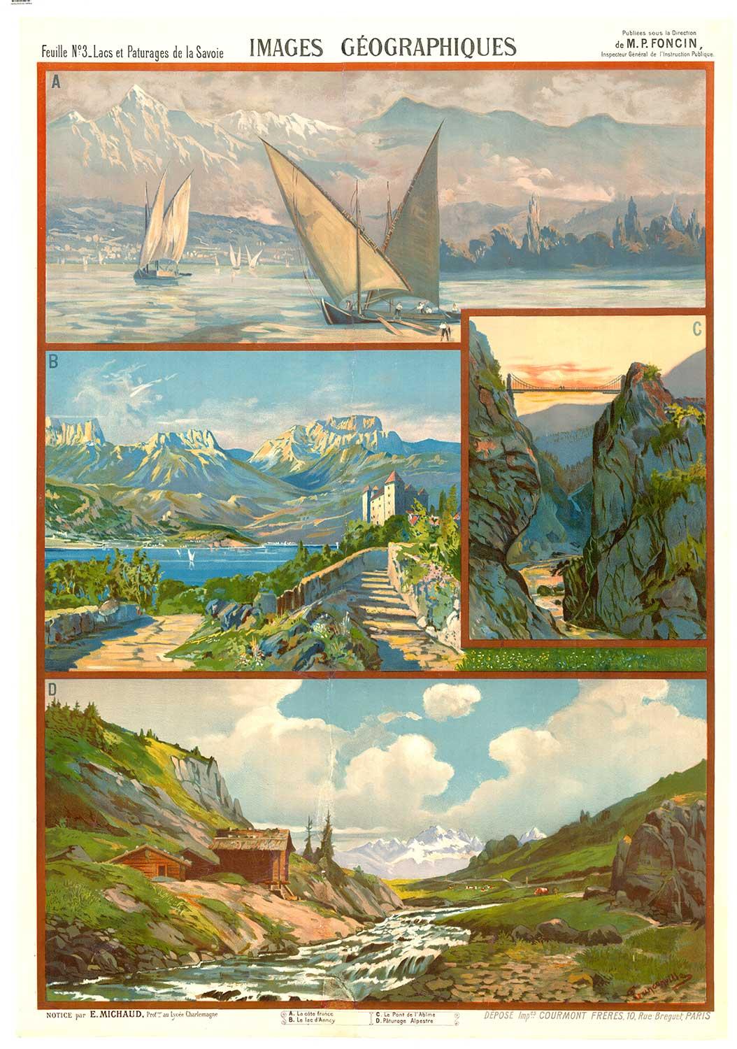
Original Images Geographiques vintage French poster on linen
Located in Spokane, WA
Images Géographiques (c. 1900). Tanconville.
Original French Lithographic Poster — Linen-Backed, Restored. Size: 41.5” x 29”
Capture the spirit of the Belle Époque with this turn...
Category
1890s Realist Landscape Prints
Materials
Lithograph

Landscape - Lithograph attr. to Nicholas Verrall - 1980s
Located in Roma, IT
Landscape is a lithograph attributed to Nicholas Verrall in the 1980s.
Hand-signed.
Numbered, Edition, 9/99.
Very Good conditions.
The artwork is ...
Category
1980s Contemporary Figurative Prints
Materials
Lithograph
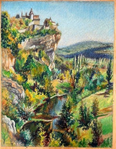
Mid Century French Original Pastel Painting of a Cliffside Village
By Josine Vignon
Located in Cirencester, Gloucestershire
Title: "Mid Century French Original Pastel Painting of a Cliffside Village"
Artist: Josine Vignon (French 1922-2022)
Medium: Oil Pastel on artist paper
Size: 25.5 (height) x 19.75...
Category
Mid-20th Century Impressionist Landscape Paintings
Materials
Oil Pastel
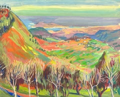
1960's French Signed Post Impressionist Painting Far Reaching Valley Views
Located in Cirencester, Gloucestershire
gouache painting on artist paper, unframed
signed by P. Bellenger and dated 62'
painting: 15 x 18 inches
provenance: private collection, France
condition: very good and sound condition
Category
Mid-20th Century Post-Impressionist Landscape Paintings
Materials
Gouache