Items Similar to Map of Arras - Etching by George Braun - Late 16th Century
Want more images or videos?
Request additional images or videos from the seller
1 of 2
George BraunMap of Arras - Etching by George Braun - Late 16th CenturyLate 16th Century
Late 16th Century
$708.21
£539.37
€600
CA$992.75
A$1,086.10
CHF 567.25
MX$12,979.12
NOK 7,126.69
SEK 6,707.34
DKK 4,570.32
About the Item
This Map of Arras is an original etching realized by George Braun (1541 – 1622)
The state of preservation of the artwork is good but aged with trace of foxing that doesn't affect the image.
Interesting B/W etching on coeval paper,this artwork represents skilfully a detailed view of the city of Arras through confident strokes.On the lower right the inscription "ATREBATVM, EPISCOPALIS ET METROPOLITICA CIVITAS" printed.
The etching belongs to the collection "Civitates Orbis Terrarurm" realized by Georg Braun and Frans Hogenberg.
The Civitates Orbis Terrarum (Atlas of the Cities of the World) was the second oldest printed atlas in the history of world cartography and the first atlas totally dedicated to topographical views. The first volume of this collection was published in Cologne in 1572; the following in 1575, 1581, 1588, and 1598. The sixth and final volume appeared in 1617, shortly before the extensive devastation wreaked by the Thirty Years’ War.
This artwork is shipped from Italy. Under existing legislation, any artwork in Italy created over 70 years ago by an artist who has died requires a licence for export regardless of the work’s market price. The shipping may require additional handling days to require the licence according to the final destination of the artwork.
- Creator:George Braun
- Creation Year:Late 16th Century
- Dimensions:Height: 8.67 in (22 cm)Width: 20.48 in (52 cm)Depth: 0.04 in (1 mm)
- Medium:
- Period:
- Framing:Framing Options Available
- Condition:Insurance may be requested by customers as additional service, contact us for more information.
- Gallery Location:Roma, IT
- Reference Number:Seller: M-1087671stDibs: LU65036931232
About the Seller
4.9
Platinum Seller
Premium sellers with a 4.7+ rating and 24-hour response times
1stDibs seller since 2017
7,795 sales on 1stDibs
Typical response time: 1 hour
- ShippingRetrieving quote...Shipping from: Roma, Italy
- Return Policy
Authenticity Guarantee
In the unlikely event there’s an issue with an item’s authenticity, contact us within 1 year for a full refund. DetailsMoney-Back Guarantee
If your item is not as described, is damaged in transit, or does not arrive, contact us within 7 days for a full refund. Details24-Hour Cancellation
You have a 24-hour grace period in which to reconsider your purchase, with no questions asked.Vetted Professional Sellers
Our world-class sellers must adhere to strict standards for service and quality, maintaining the integrity of our listings.Price-Match Guarantee
If you find that a seller listed the same item for a lower price elsewhere, we’ll match it.Trusted Global Delivery
Our best-in-class carrier network provides specialized shipping options worldwide, including custom delivery.More From This Seller
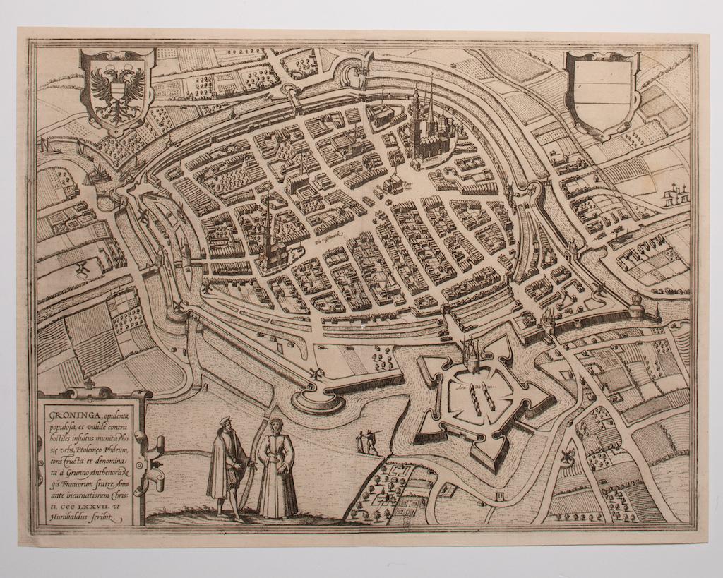
View AllMap of Groningen - Etching by George Braun - Late 16th Century
Located in Roma, IT
This map of Groninga is an original etching realized by George Braun and Franz Hogenberg, and part of the series "Civitates Orbis Terrarum".
The state of preservation of the artwork...
Category
16th Century Figurative Prints
Materials
Etching

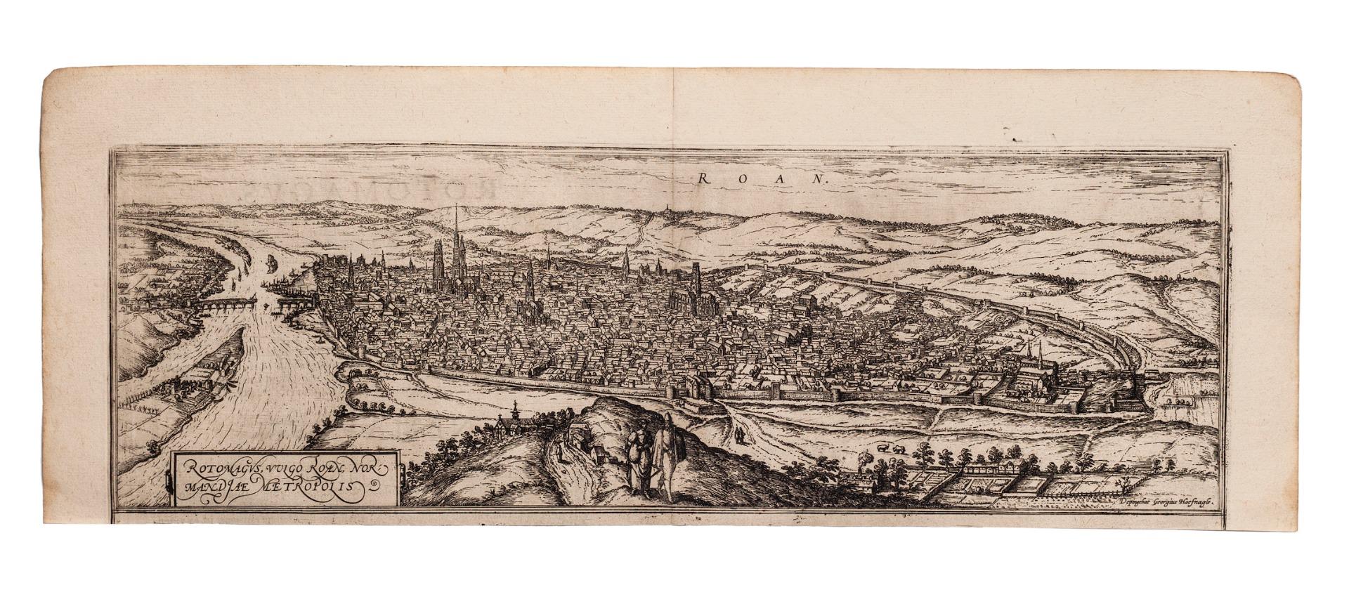
Map of Rouen - Original Etching by G.Braun and F. Hogenberg - Late 16th Century
By Franz Hogenberg
Located in Roma, IT
This Map of Roan is an original etching realized by G. Braun and F. Hogenberg within the famous Atlas "Civitates Orbis Terrarum".
The state of preservation of the artwork is aged wi...
Category
16th Century Figurative Prints
Materials
Etching
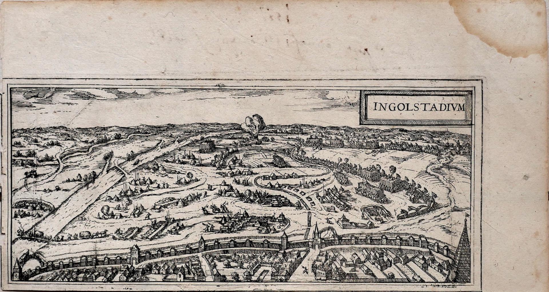
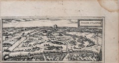
Map of Ingolstadt - Etching by George Braun- Late 16th Century
Located in Roma, IT
This Ingolstadium is an original etching realized by George Braun and Franz Hogenberg.
The state of preservation of the artwork is good but aged and at the top on the right angle yo...
Category
16th Century More Prints
Materials
Etching
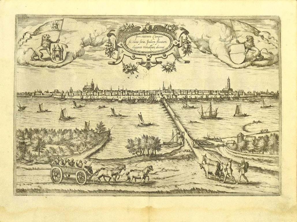
Map of Kampen, Netherlands - by G. Braun and F. Hogenberg - Late 16th Century
By Franz Hogenberg
Located in Roma, IT
This map of Kampen (the ancient Campensis) is an original etching realized by George Braun and Franz Hogenberg as part of the famous Series "Civitates Orbis Terrarum".
The “Civita...
Category
16th Century Figurative Prints
Materials
Etching

Map of the Netherlands - Etching by G. Braun and F. Hogenberg -Late 16th Century
By Franz Hogenberg
Located in Roma, IT
Map of the Netherlands is an original etching realized by George Braun and Franz Hogenberg, as part of the "Civitates Orbis Terrarum".
The “Civitates Orbis Terrarum” (Atlas of Citi...
Category
16th Century Figurative Prints
Materials
Etching

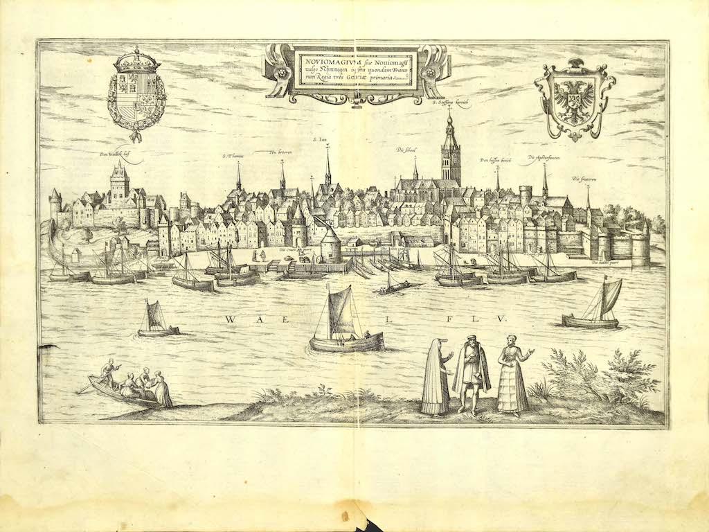
Map of Nijmegen - Etching by G. Braun and F. Hogenberg - Late 16th Century
By Franz Hogenberg
Located in Roma, IT
This map of Noviomagvs is an original etching realized by Georg Braun and Franz Hogenberg as part of the famous series "Civitates Orbis Terrarum".
The state of preservation of the ...
Category
16th Century Figurative Prints
Materials
Etching

You May Also Like
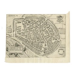
Antique Map of the City of Arnhem by Guicciardini, 1613
Located in Langweer, NL
Antique map titled ?Arnhemium Gelriae in Ripa Rheni Opp?. Plan of Arnhem in the province of Gelderland, The Netherlands, Holland. This map originates from the 1613 edition of 'Discri...
Category
Antique 17th Century Maps
Materials
Paper
$179 Sale Price
20% Off
18th Century Map Engraving - Newport, a Strong Sea-Port Town in Flanders
Located in Corsham, GB
A map of Nieuwpoort, anglicised to 'Newport', in northern Belgium. There is a panorama in the upper quarter depicting major landmarks. Below is a plan of the town, including its strong defences and ships at the port in the lower register. Inscribed with the title in plate to the lower edge, 'Newport a Strong Sea-Port Town...
Category
18th Century More Prints
Materials
Engraving

$269 Sale Price
20% Off
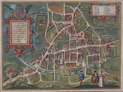
Map of Cambridge, c.1572 engraving by Braun & Hogenberg
Located in London, GB
To see our other views of Oxford and Cambridge, scroll down to "More from this Seller" and below it click on "See all from this Seller" - or send us a message if you cannot find the ...
Category
16th Century Realist Landscape Prints
Materials
Engraving
Antique Map of the City of Zutphen by Guicciardini, 1612
Located in Langweer, NL
Antique map Zutphen titled 'Zutphen'. This map depicts the city of Zutphen, Gelderland, The Netherlands. Originates from 'Beschryvinghe van alle de Neder-landen anderssins ghenoemt N...
Category
Antique 17th Century Maps
Materials
Paper
Antique Map of Douai 'France' by Braun & Hogenberg, circa 1575
Located in Langweer, NL
Beautiful map in excellent condition. This map depicts the city of Douai (France) and originates from 'Civitates Orbis Terrarum'.
Category
Antique 16th Century Maps
Materials
Paper

Map of Cambridge, engraving Pieter van der Aa after David Loggan
By Pieter Van Der Aa
Located in London, GB
Pieter van der Aa (1659 - 1733), after David Loggan (1634 - 1692)
Map of Cambridge
Engraving
12 x 16 cm
An eighteenth-century view of Cambridge, engraved by Pieter van der Aa after ...
Category
Early 18th Century Realist Prints and Multiples
Materials
Engraving
