Items Similar to John Thomson (1777-1840) - 1830 Map Engraving, Chart of the World


Want more images or videos?
Request additional images or videos from the seller
1 of 6
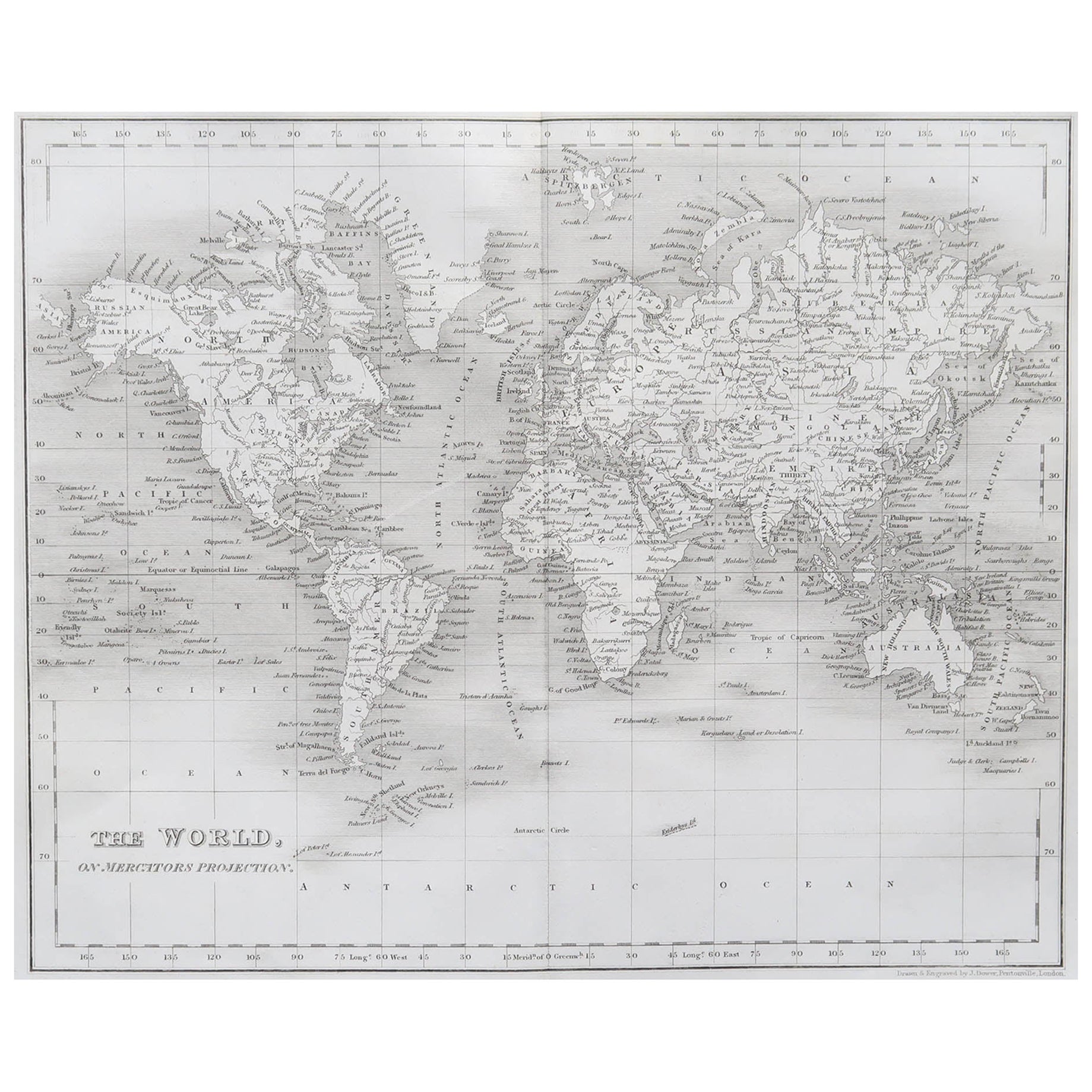
John ThomsonJohn Thomson (1777-1840) - 1830 Map Engraving, Chart of the World1830
1830
$316
$39520% Off
£246.08
£307.6020% Off
€279.91
€349.8920% Off
CA$455.09
CA$568.8720% Off
A$499.41
A$624.2620% Off
CHF 260.84
CHF 326.0520% Off
MX$5,970.97
MX$7,463.7120% Off
NOK 3,304.04
NOK 4,130.0520% Off
SEK 3,081.64
SEK 3,852.0520% Off
DKK 2,090.57
DKK 2,613.2220% Off
About the Item
A fine engraved map of the world on Mercator's projection, from the second edition of John Thomson's 'New General Atlas' published in 1830. On paper.
- Creator:John Thomson (1941 - 1840, American)
- Creation Year:1830
- Dimensions:Height: 20.48 in (52 cm)Width: 24.41 in (62 cm)
- Medium:
- Period:
- Condition:The condition is typical for a picture of this age including some discolouration, foxing and small tears around the edges of the paper, with some creases and small losses to the lower right edge in the margin.
- Gallery Location:Corsham, GB
- Reference Number:Seller: rx7151stDibs: LU881313975962
John Thomson
Thomson lives and paints in California, Mexico and the Caribbean. His paintings, drawings, prints, ceramics, and color photographs have been exhibited by many leading galleries and design firms throughout the United States, and abroad. Over 4000 of his abstract creations are represented in private, and public collections around the world. Thomson earned his BA in Arts, 1964 from Chico State College and MA in Painting, 1970, from Chico State University.
About the Seller
4.9
Platinum Seller
Premium sellers with a 4.7+ rating and 24-hour response times
Established in 2010
1stDibs seller since 2018
1,432 sales on 1stDibs
Typical response time: 3 hours
- ShippingRetrieving quote...Shipping from: Corsham, United Kingdom
- Return Policy
More From This Seller
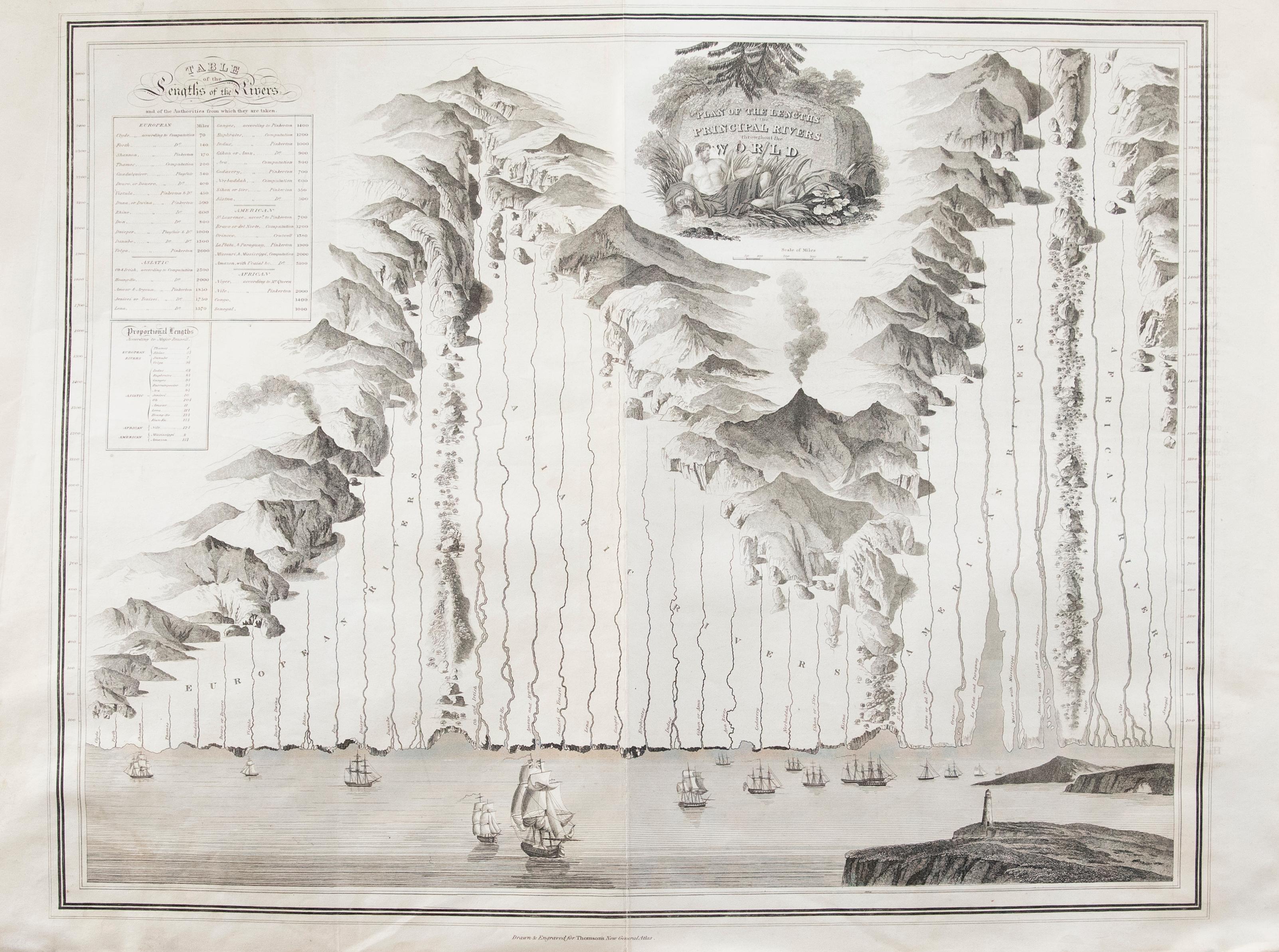
View AllJohn Thomson (1777-1840) - 1830 Map Engraving, The Rivers of the World
By John Thomson
Located in Corsham, GB
A fine engraved chart table showing the lengths of the principal rivers across the world, from the second edition of John Thomson's 'New General Atlas' published in 1830. On paper.
Category
Early 19th Century More Prints
Materials
Engraving
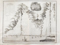
$349 Sale Price
20% Off
After Johann B. Homann (1664-1724) - 19th C, General Map of Spain and Portugal
Located in Corsham, GB
General map of Spain and Portugal divided into its current provinces by D.T. Lopez, newly drawn by F. L. G. in Nuremberg at the Heret of Homann, 1782. A double-page engraved map with...
Category
19th Century More Prints
Materials
Engraving

After John Arrowsmith (1790-1873) - 20th Century Digital Print, South America
Located in Corsham, GB
Inscribed: South America from original documents. Including the survey by the officers of H.M. Ships Adventure and Beagle. Presented in a light wooden frame. On paper.
Category
20th Century More Prints
Materials
Digital
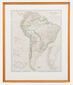
$196 Sale Price
20% Off
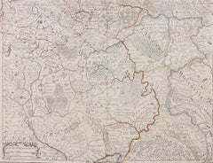
Henri Liebaux and Guillaume De L'Isle - 1706 Engraving, Map Of The Moscovites
Located in Corsham, GB
A early 18th Century map showing a section of Muscovite Russia. This is the lower half of the complete original map, finished with hand colouring. The artist's names are engraved in ...
Category
18th Century More Prints
Materials
Engraving
18th Century Map Engraving - Plan of the Works of the City of Messina, Sicily
Located in Corsham, GB
A map of Messina, a harbour city in northeast Sicily. Inscribed with the title in plate to the lower edge, 'Plan of the Works of the City of Messina, one of the strongest and most co...
Category
18th Century More Prints
Materials
Engraving

$285 Sale Price
20% Off
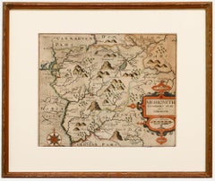
Christopher Saxton & William Kip - Framed 17th Century Engraving, Merionith
Located in Corsham, GB
An early copper-engraved county map of Merioneth, based on the work of Christopher Saxton (1540-1610), and engraved by William Kip (fl.1598-1610) for William Camden's 'Britannia'. Wi...
Category
18th Century More Prints
Materials
Engraving
You May Also Like
Original Antique Map of The World by Dower, circa 1835
Located in St Annes, Lancashire
Nice map of the World
Drawn and engraved by J.Dower
Published by Orr & Smith. C.1835
Unframed.
Free shipping
Category
Antique 1830s English Maps
Materials
Paper

Map of the World - Original Etching - 1820
Located in Roma, IT
Map of the World is an Original Etching realized by an unknown artist of 19th century in 1820.
Very good condition on two sheets of white paper joine...
Category
1820s Modern Figurative Prints
Materials
Etching

Antique Map of the Eastern Hemisphere by Wyld, 1842
Located in Langweer, NL
Antique map titled 'Eastern Hemisphere'. Large map depicting the continents Europe, Asia, Afrika and Australia.
Artists and Engravers: James Wyld (1812–1887) was a British geograph...
Category
Antique 19th Century Maps
Materials
Paper

Antique Map of the World by Balbi '1847'
Located in Langweer, NL
Antique map titled 'Planisphère'. Original antique map of the world. This map originates from 'Abrégé de Géographie (..)' by Adrien Balbi. Pub...
Category
Antique Mid-19th Century Maps
Materials
Paper

$234 Sale Price
20% Off
Antique Map of the World by Ferrario '1831'
Located in Langweer, NL
Original antique map of the world. This print originates from 'Costume Antico e Moderno: Palestine, China, India, Oceania' by Ferrario. Publis...
Category
Antique Mid-19th Century Prints
Materials
Paper

$187 Sale Price
20% Off
Antique Map of the World, Mercator Projection, by Wyld, '1845'
Located in Langweer, NL
Antique map titled 'The World'. Original antique world map, on Mercator's projection. This map originates from 'An Atlas of the World, Compr...
Category
Antique Mid-19th Century Maps
Materials
Paper

$328 Sale Price
20% Off
More Ways To Browse
Blah Blah Art
Botanical Print Plates
California Travel Poster
Campari Vintage Art Posters
Canadian National Posters Original
Carlingford Lough
Cccp Space Poster
Creole Dancer
Dali Fruit
David Shrigley The World
El Al Airlines
English Roses Prints
Ghibli Poster
Hans Unger
Japan Airlines Poster
John Lennon Imagine
Jungfrau Poster
Laure Prouvost