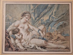
L'amour prie Vénus de lui rendre ses armes
View Similar Items


1 of 5
Louis Marin BonnetL'amour prie Vénus de lui rendre ses armes1768
1768
About the Item
- Creator:Louis Marin Bonnet (1736 - 1793, French)
- Creation Year:1768
- Dimensions:Height: 10.32 in (26.2 cm)Width: 14.1 in (35.8 cm)
- Medium:
- Period:1760-1769
- Condition:
- Gallery Location:PARIS, FR
- Reference Number:1stDibs: LU2507212417432
Authenticity Guarantee
In the unlikely event there’s an issue with an item’s authenticity, contact us within 1 year for a full refund. DetailsMoney-Back Guarantee
If your item is not as described, is damaged in transit, or does not arrive, contact us within 7 days for a full refund. Details24-Hour Cancellation
You have a 24-hour grace period in which to reconsider your purchase, with no questions asked.Vetted Professional Sellers
Our world-class sellers must adhere to strict standards for service and quality, maintaining the integrity of our listings.Price-Match Guarantee
If you find that a seller listed the same item for a lower price elsewhere, we’ll match it.Trusted Global Delivery
Our best-in-class carrier network provides specialized shipping options worldwide, including custom delivery.You May Also Like
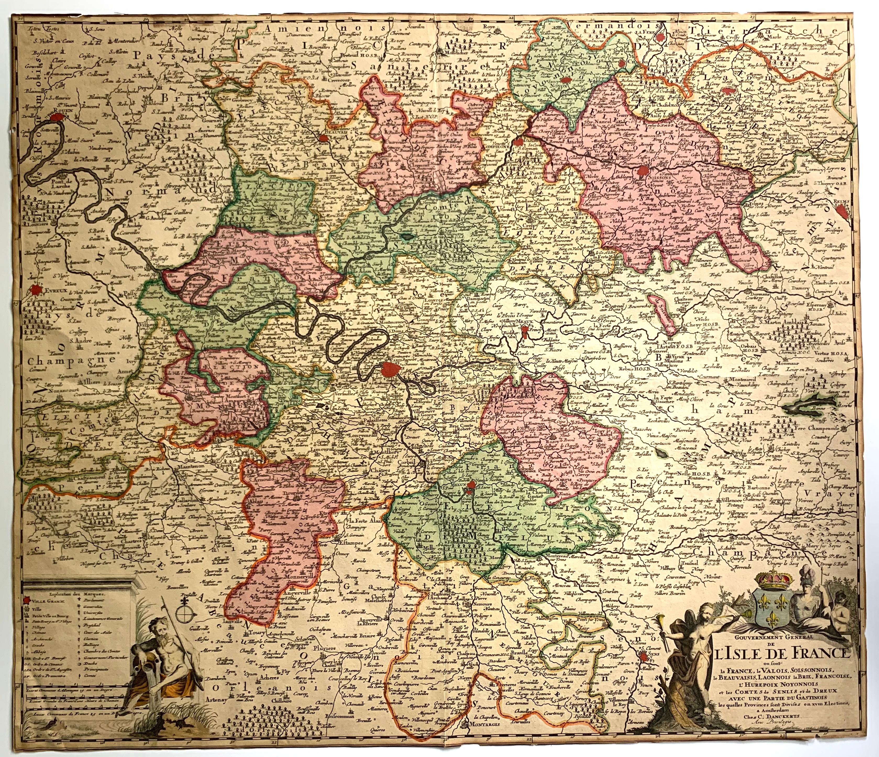
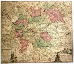
L'Isle de France map
By Cornelis Danckerts II
Located in Wilton Manors, FL
Gouvernement general de l'Isle de France : ou sont la France, le Valois, Soissonnois, le Beauvaisis, Laonnois, la Brie, Francoise, l'Hurepoix noyonnois et les comtes de Senlis et de ...
Category
17th Century More Prints
Materials
Laid Paper, Engraving
Canterbury: An Original 16th C. Framed Hand-colored Map by Braun & Hogenberg
By Franz Hogenberg
Located in Alamo, CA
This is a framed 16th century map and city view of Canterbury, England entitled "Cantuarbury" by Braun & Hogenburg, from their famous landmark atlas of city views 'Civitates Orbis Terrarum' (Atlas of the Cities of the World), which was first published in Cologne, Germany in 1572. The map of Canterbury was first published in 1588. It depicts a detailed birdseye view of the completely walled and fortified city of Canterbury, with its cathedral the most prominent feature. The coat of arms of England, Canterbury, and the Archbishop of Canterbury are included.
This beautifully hand-colored map is presented in a gold-colored wood frame with a beaded inner trim and a paprika-colored mat that highlights details in the map. The frame measures 18.75" high by 22.25" wide by 0.875" deep. There is a central vertical fold, as issued. The map is in excellent condition.
Braun and Hogenberg's 'The Civitates Orbis Terrarum' was the second atlas of maps ever published and the first atlas of cities and towns of the world. It is one of the most important books published in the 16th century. Most of the maps in the atlas were engraved by Franz Hogenberg and the text, with its descriptions of the history and additional factual information of the cities, was written by a team of writers and edited by Georg Braun. The work contained 546 bird-eye views and map views of cities and towns from all over the world. It gave graphic representation of the main features of the illustrated cities and towns, including the buildings and streets. Although the ordinary buildings are stylized, the principal buildings are reproduced from actual drawings created on location. The principal landmarks and streets can still be recognized today. In addition, the maps often include the heraldic arms of the city, the nature of the surrounding countryside, the important rivers, streams and harbors, even depicting stone bridges, wooden pontoons, flat-bottomed ferries, ships and working boats, wharves and jetties, as well as land-based activities, including horsemen, pedestrians, wagons, coaches, and palanquins. Small vignettes are often included which illustrate the trade, occupations and habits of the local inhabitants, such as agriculture, paper-making and textiles, as well as local forms of punishment, such as gibbets, wheels, floggings etc. Large figures dressed in their local costume are often presented out of proportion in the foreground. The aim of the authors was to give as much information as possible in a pleasing visual form. They succeeded in creating maps that were both informative and decorative works of art. The atlas is a wonderful glimpse of life in medieval Europe.
Georg Braun (1541-1622) was German Catholic...
Category
16th Century Old Masters Landscape Prints
Materials
Engraving

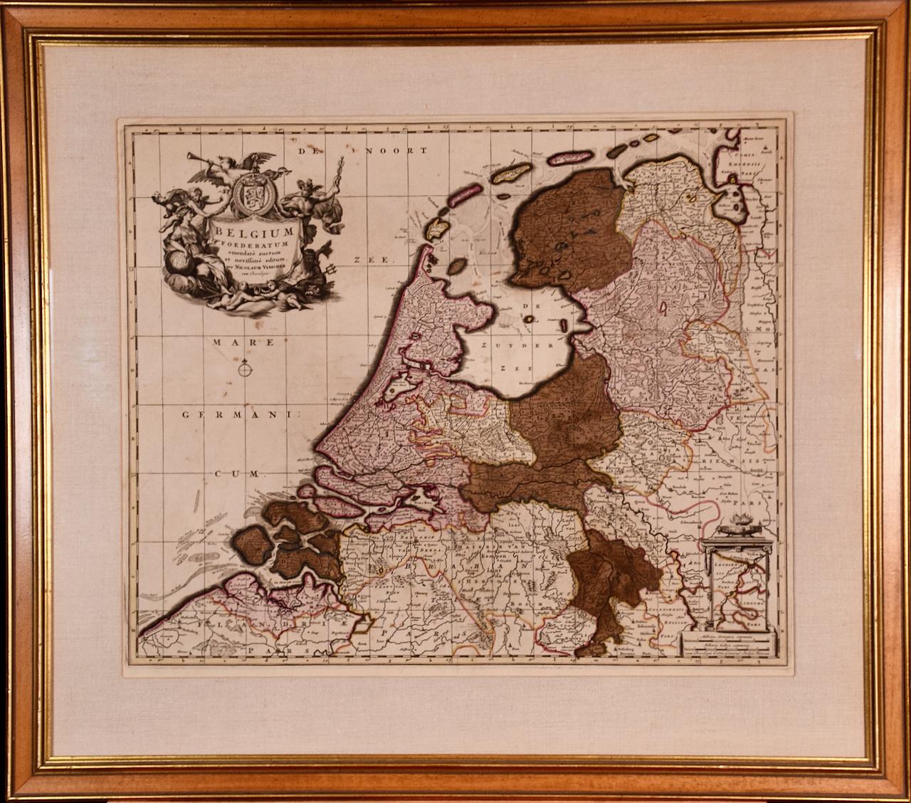
Belgium and the Netherlands: A Hand-colored 17th Century Map by Visscher
By Nicolaus Visscher
Located in Alamo, CA
This is an original hand-colored 17th century map of Belgium by Nicolaus (Nicolas) Visscher II entitled "Belgium Foederatum emendate auctum et novissime editum", published in Amsterdam in 1678. The map shows the seven provinces comprising the Belgium federation or the Republic of the Seven United Netherlands or the Dutch Republic as it was also known. The republic was formed when an alliance of seven Dutch provinces in the Spanish Netherlands revolted against rule by Spain in 1579 (the Union of Utrecht) and declared their independence in 1581 (the Act of Abjuration). The seven provinces were Groningen, Frisia, Overijssel, Guelders, Utrecht, Holland and Zeeland. This was a predecessor state to the Netherlands and the first fully independent Dutch nation state. Amsterdam, Delft, Rouen, Utrecht, Brugge, Ghent, and Antwerp are all included on the map. A small inset map in the lower right depicts the course of the Maas River from Maastricht to Wessem. There is a decorative cartouche in the upper left corner and a distance scale cartouche in the lower right corner.
The map is presented in an attractive antiqued medium brown-colored wood frame with gold-colored inner and outer trim and a light tan-colored fabric mat. The frame measures 26.63" high by 30" wide by 0.75" deep. There is some darkening of the red areas in the map, presumably related to oxidation of the original iron containing pigment over time. There are also a few scattered spots. The map is otherwise in very good condition.
The Visscher family were one of the great cartographic families of the 17th century. Begun by Claes Jansz Visscher...
Category
Late 17th Century Other Art Style Landscape Prints
Materials
Engraving

Meissen, Germany : A Large Framed 18th Century Map by Petrus Schenk
Located in Alamo, CA
This is a hand-colored 18th century map of the Meissen region of Germany, entitled "Geographischer Entwurff Derer Aemmter Meissen als Creys-Procuratur-Schul-und Stiffts-Ammt benebst ...
Category
Mid-18th Century Old Masters Landscape Prints
Materials
Engraving

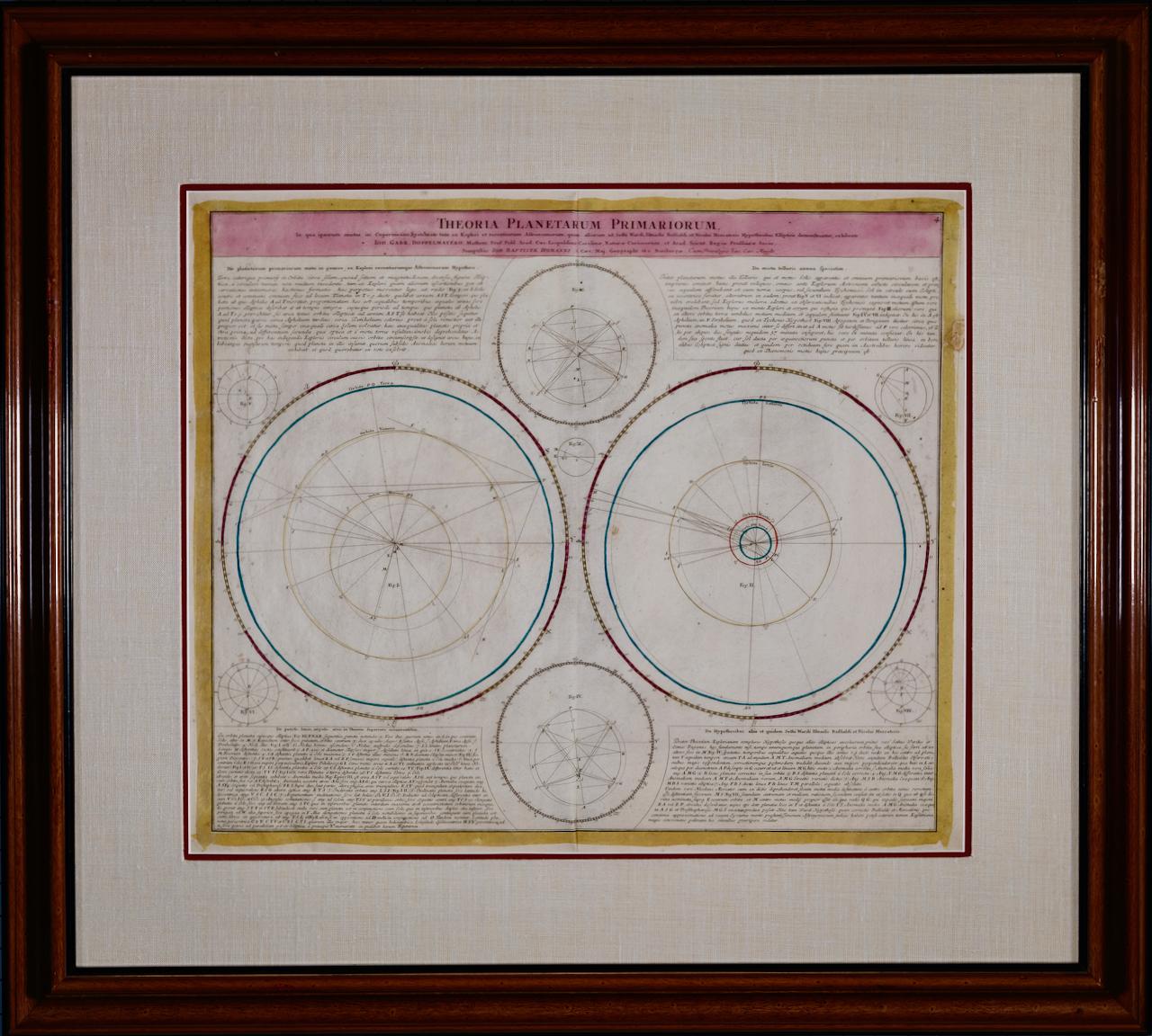
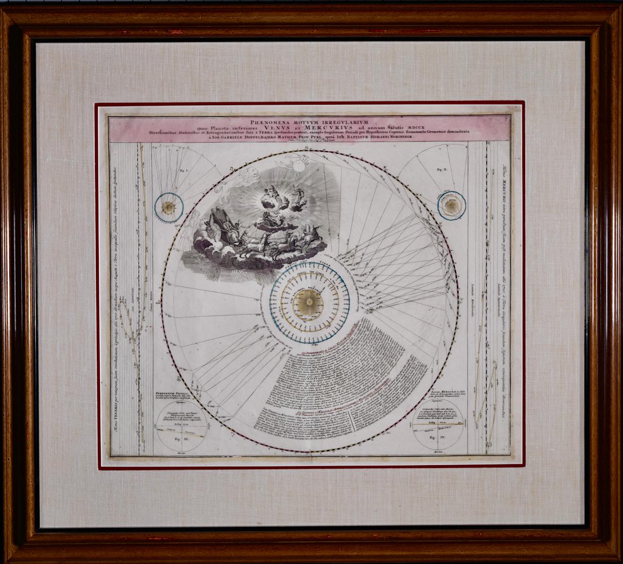
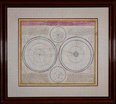
Theories of Planetary Motion: An 18th C. Framed Celestial Map by Doppelmayr
By Johann Gabriel Doppelmayr 1
Located in Alamo, CA
This 18th century hand-colored copperplate celestial map by Johann Doppelmayr entitled "Theoria Planetarum Primariorum In qua ipsorum motus in Copernican...
Category
Early 18th Century Landscape Prints
Materials
Engraving
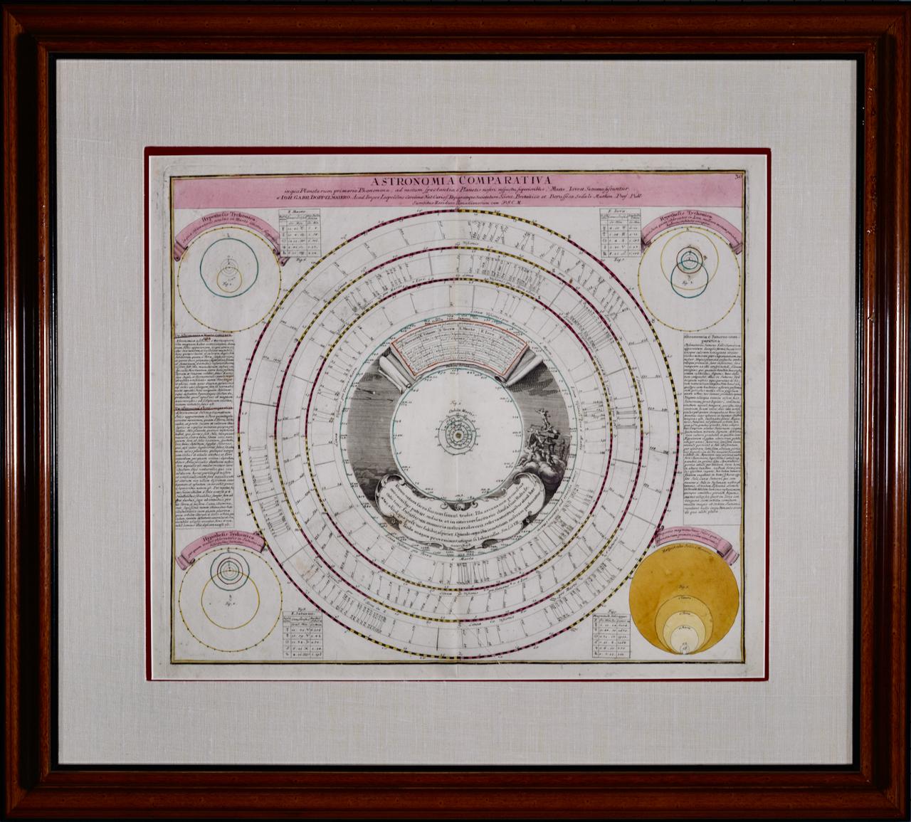
Theories of Planetary Orbits: A Framed 18th C. Celestial Map by Doppelmayr
By Johann Gabriel Doppelmayr 1
Located in Alamo, CA
This 18th century hand-colored copperplate celestial map by Johann Doppelmayr entitled "Astronomia Comparativa in qua Planetarum Primaria Phaenomena" (Co...
Category
Early 18th Century Landscape Prints
Materials
Engraving
