Important giant Map of Asia, for the King of France, 1696
View Similar Items


Want more images or videos?
Request additional images or videos from the seller
1 of 4
Nicolas de FerImportant giant Map of Asia, for the King of France, 16961698
1698
About the Item
- Creator:Nicolas de Fer (1646 - 1720, French)
- Creation Year:1698
- Dimensions:Height: 43.12 in (109.5 cm)Width: 64.18 in (163 cm)
- Medium:
- Movement & Style:
- Period:Late 17th Century
- Framing:Frame IncludedFraming Options Available
- Condition:
- Gallery Location:Amsterdam, NL
- Reference Number:1stDibs: LU147128029142
About the Seller
No Reviews Yet
Vetted Seller
These experienced sellers undergo a comprehensive evaluation by our team of in-house experts.
1stDibs seller since 2021
More From This SellerView All
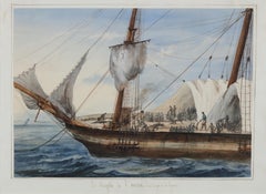
- Portrait of a Slave Ship: 'Le Negrito à l’ancre. Dans le port de la havanne'Located in Amsterdam, NLFRANÇOIS MATHURIN ADALBERT, BARON DE COURCY (1805-1839) 'Le Negrito à l’ancre. Dans le port de la havanne' Indistinctly signed lower left Titled on the mount Pencil and watercolour, heightened with white, on paper, 24.8 x 34.6 cm Literature: The present watercolour will be illustrated in: - Prof. Manuel Garcia’s projected book on the disease and the slave trade provisionally titled “Fighting the Yellow Demon of Fever: The Struggle against Disease in the Illegal Slave Trade”. - Prof. Micael Zeuske’s forthcoming Global history of slave trade. Exhibited: Mexico City, 1998, Palacio Virreinal, El Barón de Courcy, illustrationes de un viaje, 1831-1833, no. 108 Note: Baron de Courcy was in the Caribbean in late 1832 and early 1833, following his tour of Mexico in 1832, on the last leg of his “Grand Voyage...Category
Mid-19th Century Old Masters Figurative Drawings and Watercolors
MaterialsGouache, Pencil, Paper, Watercolor
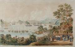
- 1854 Funeral of R. Williams at Gyokusen-ji Temple, Shimoda, with Commodore PerryLocated in Amsterdam, NLWilhelm Heine (Dresden 30 January 1827-Löbnitz 5 October 1885) ‘Funeral of Robert Williams in the cemetery of the Temple Gyokusen-ji at Shimoda in April 1854’ With a sticker on the reverse of the frame by Coupil & Co. 1855 Watercolour on paper, H. 57 x W. 92 cm Depicted is the Bay of Shimoda with seven American ships including the two paddle-wheel warships USS Mississippi and Susquehanna. On the Gyokus- en-ji temple grounds on the right is the coffin in the middle with the remains of US marine Robert Williams, ready to be lowered into the grave. Looking on from the left are the Buddhist monks and Japanese officials who joined the first Christian funeral on Japanese soil. Around the grave are US marines, Commodore Perry...Category
Mid-19th Century Figurative Drawings and Watercolors
MaterialsPaper, Ink, Watercolor, Gouache
 Price Upon RequestFree Shipping
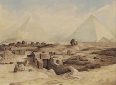
 - Devotion in the Dessert near the pyramids of Gizeh, circa 1919By Marius BauerLocated in Amsterdam, NLMarius Bauer (1867-1932) ‘Devotie in de Woestijn’ (Devotion in the Dessert near the pyramids of Gizeh, circa 1919) Signed lower right and titled lower left Watercolour on paper, H...Category
Early 20th Century Impressionist Landscape Drawings and Watercolors
MaterialsPaper, Ink, Watercolor, Pencil
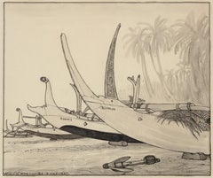
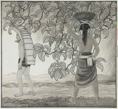
- Beach of Kusambe, Bali 1937Located in Amsterdam, NLFour outrigger proa’s on the beach of Kusambe, Bali, 1937 Signed with initials, dated and described with location bottom left Pencil and ink on paper, 29.7 x 35 cm In ebonized frame with white mount WILLEM OTTO WIJNAND NIEUWENKAMP (1874-1950) Nieuwenkamp was born on July 27th 1874 in Amsterdam. His father owned sailing ships sailing to Indonesia and hearing the stories of the returning captains evoked in the young Nieuwenkamp an obsession for distant lands and adventure. After a failed attempt by his father to have his son make a career in his business, Nieuwenkamp attended the Academy for Decorative Art in Amsterdam. However, he left within one year to go his own way. He was an autodidact and a great experimenter with new techniques, particularly in the art of etching. Nieuwenkamp was a very focused man with the discipline of a scientist tempered by the sensitivity of an artist, a lust for adventure, a natural appreciation for ethnic arts and an enormous ambition to tread new paths. In 1898 he visited Indonesia for the first time and on his second visit in 1903-1904 he went on to Bali and became the first foreign artist to love Bali and the Balinese with a passion. Having secured agreements with several museums in the Netherlands to obtain Balinese art and objects for their collections, Nieuwenkamp immediately started to purchase and order a wide range of ethnographic art and objects from local artists and craftsmen. Through his drawings and books, he gave an excellent impression of Balinese art and culture at that time. Since 1854 Northern Bali was under Dutch...Category
1930s Art Nouveau Landscape Drawings and Watercolors
MaterialsPaper, India Ink, Pencil
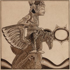
- Statue of Vishnu Garuda, Bali, 1904Located in Amsterdam, NLStatue of Vishnu Garuda, Bali, 1904 Signed with initials Pencil and ink on paper, 21.4 x 21.3 cm Literature: Bruce W. Carpenter, W.O.J. Nieuwenkamp. First European Artist in Bali,...Category
Early 1900s Art Nouveau Landscape Drawings and Watercolors
MaterialsPaper, Pencil, India Ink
- Incoming Rain, Bali, 1937Located in Amsterdam, NLIncoming rain, Den Pasar, Bali 1937 Signed with initials, dated and titled, bottom right Black chalk and ink on paper, 42 by 46 cm Literature: Ernst Braches en J.F. Heijbroek, W.O...Category
1930s Art Nouveau Landscape Drawings and Watercolors
MaterialsPaper, Graphite
You May Also Like
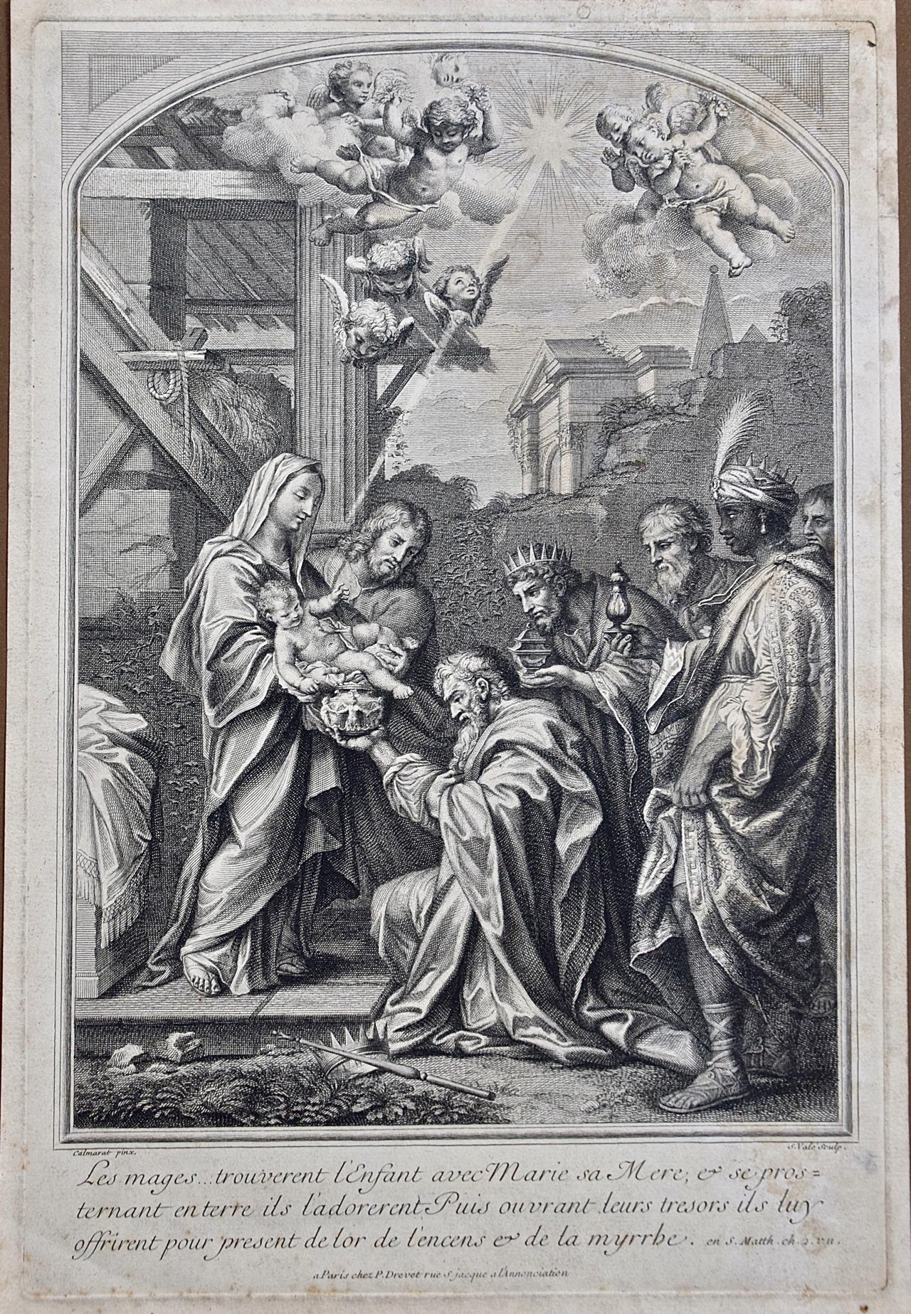
- The Gift of the Magi: An 18th C. Religious Engraving by Vale, After CalmaratLocated in Alamo, CAThis is a very rare early 18th century old master religious themed engraving entitled "Les Mages...Trouverent l'Enfant avec Marie sa Mere, et se prosternant entere ils l'adorent Puis ouvrant leurs tresors ils tuy offrirent pour present de lor de l'encens et de la myrrhe" by S. Vale after Calmaret, published in Paris by Pierre Drevet (1663-1738). The scene depicts the Magi bowing before Jesus, who is held by his mother Mary, and bringing him gifts of gold, frankincense and myrrh to demonstrate their adoration and respect. Winged cherubs fly overhead and a ray of light is focused on the spiritual couple. A cattle stall and buildings are in the background and a crown and scepter are dropped in the foreground, symbolically demonstrating that these nobles place Jesus above their titles and rank. Little is known about the artist Calmarat or the engraver S...Category
Early 18th Century Old Masters Portrait Prints
MaterialsEngraving
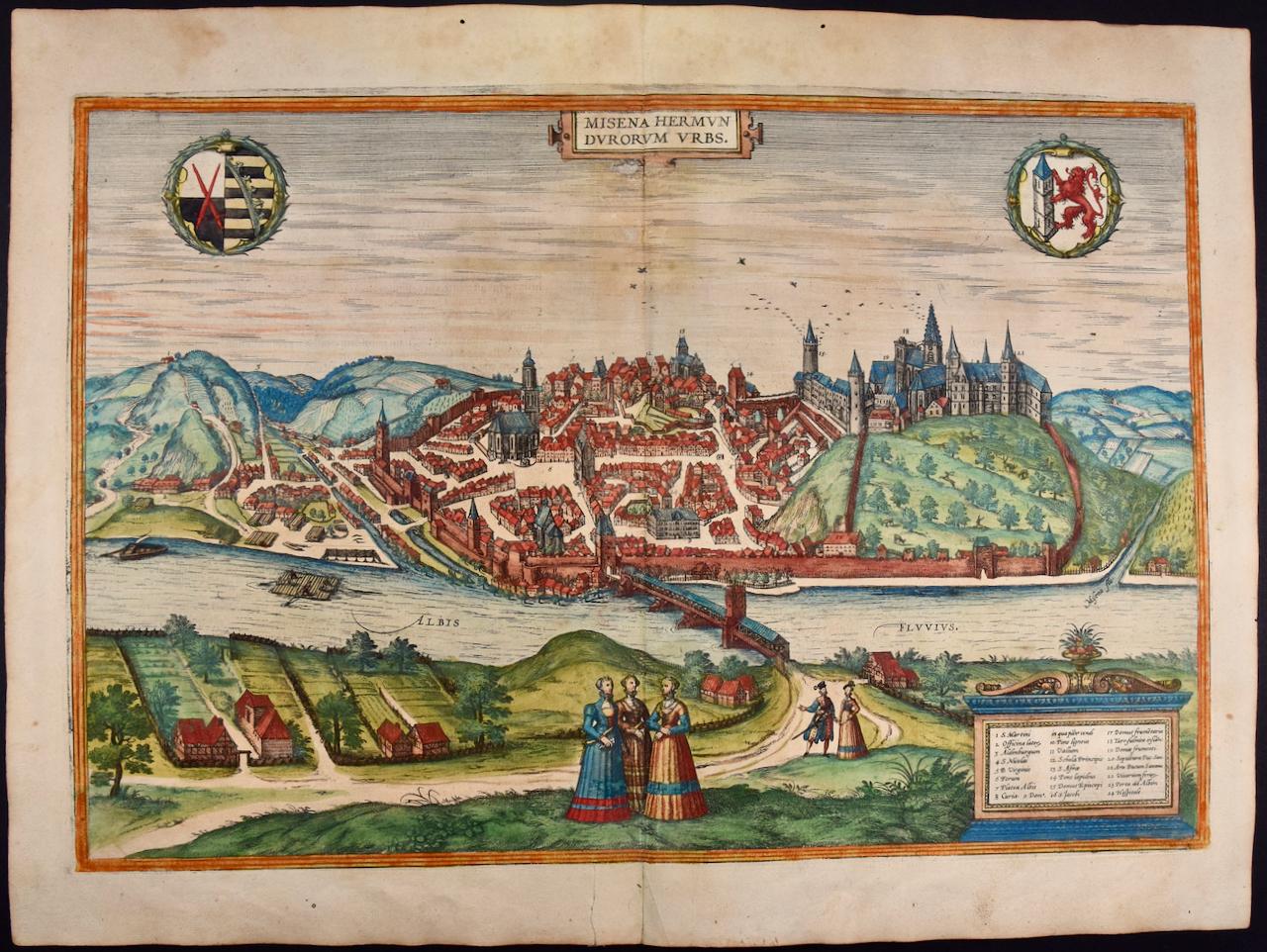
- Canterbury: An Original 16th C. Framed Hand-colored Map by Braun & HogenbergBy Franz HogenbergLocated in Alamo, CAThis is a framed 16th century map and city view of Canterbury, England entitled "Cantuarbury" by Braun & Hogenburg, from their famous landmark atlas of city views 'Civitates Orbis Terrarum' (Atlas of the Cities of the World), which was first published in Cologne, Germany in 1572. The map of Canterbury was first published in 1588. It depicts a detailed birdseye view of the completely walled and fortified city of Canterbury, with its cathedral the most prominent feature. The coat of arms of England, Canterbury, and the Archbishop of Canterbury are included. This beautifully hand-colored map is presented in a gold-colored wood frame with a beaded inner trim and a paprika-colored mat that highlights details in the map. The frame measures 18.75" high by 22.25" wide by 0.875" deep. There is a central vertical fold, as issued. The map is in excellent condition. Braun and Hogenberg's 'The Civitates Orbis Terrarum' was the second atlas of maps ever published and the first atlas of cities and towns of the world. It is one of the most important books published in the 16th century. Most of the maps in the atlas were engraved by Franz Hogenberg and the text, with its descriptions of the history and additional factual information of the cities, was written by a team of writers and edited by Georg Braun. The work contained 546 bird-eye views and map views of cities and towns from all over the world. It gave graphic representation of the main features of the illustrated cities and towns, including the buildings and streets. Although the ordinary buildings are stylized, the principal buildings are reproduced from actual drawings created on location. The principal landmarks and streets can still be recognized today. In addition, the maps often include the heraldic arms of the city, the nature of the surrounding countryside, the important rivers, streams and harbors, even depicting stone bridges, wooden pontoons, flat-bottomed ferries, ships and working boats, wharves and jetties, as well as land-based activities, including horsemen, pedestrians, wagons, coaches, and palanquins. Small vignettes are often included which illustrate the trade, occupations and habits of the local inhabitants, such as agriculture, paper-making and textiles, as well as local forms of punishment, such as gibbets, wheels, floggings etc. Large figures dressed in their local costume are often presented out of proportion in the foreground. The aim of the authors was to give as much information as possible in a pleasing visual form. They succeeded in creating maps that were both informative and decorative works of art. The atlas is a wonderful glimpse of life in medieval Europe. Georg Braun (1541-1622) was German Catholic...Category
16th Century Old Masters Landscape Prints
MaterialsEngraving
- Meissen, Germany : A Large Framed 18th Century Map by Petrus SchenkLocated in Alamo, CAThis is a hand-colored 18th century map of the Meissen region of Germany, entitled "Geographischer Entwurff Derer Aemmter Meissen als Creys-Procuratur-Schul-und Stiffts-Ammt benebst ...Category
Mid-18th Century Old Masters Landscape Prints
MaterialsEngraving
- Northern Italy: A 16th Century Hand-colored Map by Abraham OrteliusBy Abraham OrteliusLocated in Alamo, CAThis is a framed 16th century hand-colored copperplate map of northern Italy entitled "Veronae Urbis Territorium a Bernardo Bragnolo Descriptium" by Abraham Ortelius from his atlas "Theatrum Orbis Terrarum", which was the first modern atlas of the world, with the first volume published in 1570. This map was part of a subsequent volume, published in Antwerp in 1584. It was based on an earlier map by Bernardo Brognoli. This beautiful map of northern Italy is focussed on Verona and its environs, including Mantua. Lake Garda and the South Tyrol mountains are prominently depicted. There is a very large striking cartouche in the upper left and a decorative distance scale in the lower right. This striking hand-colored map of northern Italy is presented in a gold-colored wood frame and an olive green-colored mat. It is glazed with UV conservation glass. All mounting materials used are archival. The frame measures 21.5" high by 28" wide by 0.75" deep. There is a central vertical fold, as issued, with slight separation of the lower portion of the fold. There are faint spots in the upper and right margins, but the map is otherwise in very good condition. Abraham Ortelius (also known as Ortels, Orthellius, and Wortels) (1527-1598) was a Dutch cartographer, geographer, and cosmographer. He began his career as a map colorist. In 1547 he entered the Antwerp guild of St Luke as an "illuminator of maps". He had an affinity for business from an early age and most of his journeys before 1560, were for business. He was a dealer in antiques, coins, maps, and books. His business income allowed him to acquire an extensive collection of medals, coins, and antiques, as well as a large library of books...Category
16th Century Old Masters Landscape Prints
MaterialsEngraving
- Frankfort, Germany: A 16th Century Hand-colored Map by Braun & HogenbergBy Franz HogenbergLocated in Alamo, CAThis is a 16th century original hand-colored copperplate engraved map of Frankfort, Germany entitled "Francenbergum, vel ut alij Francoburgum Hassiae Opp" by Georg Braun & Franz Hogenberg, from their famous city atlas "Civitates Orbis Terrarum", published in Cologne, Germany in 1595. This is an English translation of an excerpt from the original text in the atlas: "Frankenberg or, according to others, Francoburgum, a town in Hesse. Charlemagne vested the town of Frankenberg with many freedoms and privileges, which it still enjoys to this day, and on account of its valiant and victorious soldiers awarded a signet, upon which there formerly appeared a golden castle with a tower, together with the letter F and a golden crown. Frankenberg, seen here from the northeast, lies on a hill above the River Eder. The hillside is covered with fields neatly separated by bushes and fences. Soaring above the town is the massive Liebfrauenkirche, which was modelled on St Elizabeth's church in Marburg. The New Town was founded in 1335 at the foot of the hill (right) and merged with the Old Town as late as 1556. Frankenberg was founded by Conrad of Thuringia in 1233/34 to prevent the archbishops of Mainz from expanding their sphere of influence...Category
16th Century Old Masters Landscape Prints
MaterialsEngraving
- Persia, Armenia & Adjacent Regions: A Hand-colored 17th Century Map by De WitBy Frederick de WitLocated in Alamo, CAThis colorful and detailed 17th century copperplate map by Frederick De Wit was published in Amsterdam between 1666 and 1690. It depicts the Caspian Se...Category
Late 17th Century Old Masters More Prints
MaterialsEngraving