15th Century and Earlier More Prints
to
2
1
Overall Width
to
Overall Height
to
2
244
498
4,287
3,014
30
55
71
119
222
332
756
993
555
363
179
3
2
2
2
1
1
3
Period: 15th Century and Earlier
Nature Studies from the Royal Library at Windsor Castle
By Leonardo da Vinci
Located in New York, NY
Leonardo da Vinci
"Nature Studies from the Royal Library at Windsor Castle"
The J. Paul Getty Museum, November 15, 1980 - February 15, 1981
Exhibition Poste...
Category
Renaissance 15th Century and Earlier More Prints
Materials
Offset
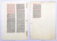
Set of Two Leaves from "Missale Frisingense" /// German Catholic Incunabula 15th
Located in Saint Augustine, FL
Artist: Erhard Ratdolt (German, 1442-1528)
Title: "Preface Page" and "Page CVI - 106"
Portfolio: Missale Frisingense
Year: 1492 (First edition)
Medium: Set of Two Original Incunabula Leaves on watermarked laid paper
Limited edition: Unknown
Printer: Erhard Ratdolt, Ausburg, Germany
Publisher: Sixtus of Tannberg, Freising, Germany
Reference: Hain No. 11303; Weale/Bohatta No. 396; Schreiber No. 4699; Pell No. 7944
Sheet size (each): approx. 11.94" x 8.13"
Condition: "Preface Page" has the occasional wormhole. Remnants of tape, a tape and a paper clip stain along its edge. Minor foxing and soiling mainly in margins. "Page CVI - 106" has remnants of tape and a small stain along its left edge. Light foxing and soiling about its sheet with some general edge wear. Have been professionally stored away for decades. They are both otherwise strong impressions in good condition with strong colors
Very rare
Notes:
Comes from Ratdolt's one volume "Missale Frisingense", (1492) (First edition), which consists of 576 pages of Gothic texts in Latin with red rubricated initials, music, and woodcut engraved illustrations. Printed in Augsburg by Erhard Ratdolt on March 17, 1492. "Preface Page" has a bull's head and cross watermark in the upper center of its sheet. Some information and old prices inscribed in pencil to their sheets.
A missal is a book that contains the prayers, chants, biblical readings, and rubrics for celebrating Mass. The first missals were found in monasteries in the 12th and 13th centuries. The term missale is Latin for "Mass book".
Biography:
Erhard Ratdolt (1442–1528) was an early German printer from Augsburg. He was active as a printer in Venice from 1476 to 1486, and afterwards in Augsburg. From 1475 to 1478 he was in partnership with two other German printers. The first book the partnership produced was the Calendarium (1476), written and previously published by Regiomontanus, which offered one of the earliest examples of a modern title page. Other noteworthy publications are the "Historia Romana of Appianus" (1477), and the first edition of "Euclid's Elements" (1482), where he solved the problem of printing geometric diagrams, the "Poeticon astronomicon", also from 1482, "Haly Abenragel" (1485), and "Alchabitius" (1503). Ratdolt is also famous for having produced the first known printer's type specimen...
Category
Old Masters 15th Century and Earlier More Prints
Materials
Laid Paper, Woodcut
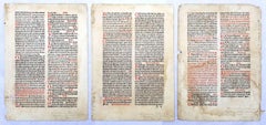
Set of Three Leaves from "Breviarium Pataviense" /// German Catholic Incunabula
Located in Saint Augustine, FL
Artist: Erhard Ratdolt (German, 1442-1528)
Title: "Vol. 6, page 10-11", "Vol. 6, page 6-7", and "Vol. 6, 28-29"
Portfolio: Breviarium Pataviense
Year: 1490 (First edition)
Medium: Set of Three Original Incunabula Leaves on watermarked laid paper
Limited edition: Unknown
Printer: Erhard Ratdolt, Ausburg, Germany
Publisher: Friedrich von Öttingen and Christoph von Schachner, Passau, Germany
Reference: Hain No. 3875; Bod-Inc No. B-542; GW No. 5426; Weale/Bohatta No. 335; Schreiber No. 3615
Sheet size (each): approx. 12.5" x 8.88"
Condition: "Vol. 6, page 10-11", "Vol. 6, page 6-7", and "Vol. 6, 28-29" all have scattered wormholes, staining, foxing, and soiling about their sheets. The latter two have remnants of tape at their edges. "Vol. 6, 28-29" has heavier staining to its sheet and edge wear about. Have been professionally stored away for decades. They are all otherwise strong impressions in overall fair condition with strong colors
Extremely rare
Notes:
Comes from Ratdolt's six volume "Breviarium Pataviense", (1490) (First edition), which consists of 378 pages of Gothic texts in Latin with red rubricated initials, psalms, readings, hymns, and woodcut engraved illustrations. Printed in Augsburg by Erhard Ratdolt on May 12, 1490. There was a subsequent printing on November 27, 1490. Both "Vol. 6, page 10-11" and "Vol. 6, 28-29" have a bow and arrow watermark in the center of their sheets. Some information and old prices inscribed in pencil to their sheets.
Breviary is a liturgical book in the Roman Catholic Church that contains the daily service for the divine office, the official prayer of the church consisting of psalms, readings, and hymns that are recited at stated hours of the day.
Biography:
Erhard Ratdolt (1442–1528) was an early German printer from Augsburg. He was active as a printer in Venice from 1476 to 1486, and afterwards in Augsburg. From 1475 to 1478 he was in partnership with two other German printers. The first book the partnership produced was the Calendarium (1476), written and previously published by Regiomontanus, which offered one of the earliest examples of a modern title page. Other noteworthy publications are the "Historia Romana of Appianus" (1477), and the first edition of "Euclid's Elements" (1482), where he solved the problem of printing geometric diagrams, the "Poeticon astronomicon", also from 1482, "Haly Abenragel" (1485), and "Alchabitius" (1503). Ratdolt is also famous for having produced the first known printer's type specimen...
Category
Old Masters 15th Century and Earlier More Prints
Materials
Laid Paper, Woodcut
Related Items
Untitled 90-13
By Dale Chihuly
Located in Lyons, CO
Color monotype.
Category
Contemporary 15th Century and Earlier More Prints
Materials
Monotype
Vultee "Vengeance" original World War 2 original vintage spotter plane poster
Located in Spokane, WA
Original Vultee "Vengeance" World War II, 1942, vintage spotter airplane poster.
Original linen-backed U. S. Naval Aviation Training Division, Nov.,...
Category
American Realist 15th Century and Earlier More Prints
Materials
Offset
$849
H 24 in W 17 in D 0.07 in
The Happy Consultation, or Modern Match
Located in Santa Monica, CA
EIGHTEENTH CENTURY BRITISH CARICATURE
THE HAPPY CONSULTATION, or MODERN MATCH, 1769 (DG 4335)
...
Category
Old Masters 15th Century and Earlier More Prints
Materials
Engraving
Mark Drew — Business Kid (Gangstarr), Silver Metallic Variant Street Art Rap
By Mark Drew
Located in Draper, UT
Mark Drew — Business Kid (Gangstarr), Silver Metallic Variant (2025)
In this striking silver variant of Business Kid (Gangstarr), Mark Drew marries nostalgic comic imagery with hip-...
Category
Contemporary 15th Century and Earlier More Prints
Materials
Screen
$3,000
H 39.7 in W 41.9 in
Blue Still Life
By Marc Chagall
Located in Washington, DC
Artist: Marc Chagall
Title: Blue Still Life
Portfolio: Derriere le Miroir 99-100
Medium: Lithograph
Date: 1957
Edition: 2500
Frame Size: 19 1/2" x 17 3/4"
Sheet Size: 15" x 11"
Signa...
Category
Modern 15th Century and Earlier More Prints
Materials
Lithograph
Four Framed Hogarth Engravings "Four Times of the Day"
Located in Alamo, CA
The four plates in this "Four Times of the Day" set were created utilizing both engraving and etching techniques by William Hogarth in 1738. Hogarth's original copper plates were refurbished where needed by James Heath and these engravings were republished in London in 1822 by Braddock, Cradock & Joy. This was the last time Hogarth's original copper plates were used for printing. Most were melted down during World War I for the construction of bombs. Printed upon early nineteenth century wove paper and with large, full margins as published by William Heath in 1822. The inscription below each print reads "Invented Painted & Engraved by Wm. Hogarth & Publish'd March 25. 1738 according to Act of Parliament".
These large folio sized "Four Times of the Day" engravings/etchings are presented in complex gold-colored wood frames with black bands and scalloped gold inner trim. A majority of each thick impressive frame is covered with glass applied near the outer edge. Each frame measures 25.75" high, 22.25" wide and 1.88" deep. There are a few small dents in the edge of these frames, which are otherwise in very good condition. "Morning" has two focal areas of discoloration in the upper margin and some discoloration in the right margin, a short tear in the left margin and a short tear or crease in the right margin. "Noon" has a spot in the upper margin that extends into the upper image, but it is otherwise in very good condition. "Evening" has a faint spot in the upper margin, but it is otherwise in very good condition. "Night" is in excellent condition.
The "Four Times of the Day" series is in the collection of many major museums, including: The British Museum, The Metropolitan Museum of Art, The Tate Museum, The Chicago Art Institute and The Victoria and Albert Museum.
Through this series Hogarth is portraying early 18th century London street life at "Four Times of the Day". His characters are exhibiting their personalities, quircks, strange activities, but he also wants to draw attention the disparities between the wealthy aristocracy and the common working class.
Plate 1, "Morning" depicts morning in Covent Garden in the winter in front of Tom King...
Category
Old Masters 15th Century and Earlier More Prints
Materials
Engraving, Etching
$6,775
H 25.75 in W 22.25 in D 1.88 in
La Chaumiere Entouree de Planchees, Old Masters Etching by Rembrandt van Rijn
Located in Long Island City, NY
Artist: Rembrandt van Rijn, After by Amand Durand, Dutch (1606 - 1669) - La Chaumiere Entouree de Planchees (B232), Year: 1878 (of original 1648), Medium: Heliogravure, Size: 5 x 6...
Category
Old Masters 15th Century and Earlier More Prints
Materials
Etching
Original "Food is a Weapon, Don't Waste It!" vintage World War Two poster
Located in Spokane, WA
Original WWII poster: Food Is a Weapon Don't Waste It!. Professional acid-free archival linen backed and ready to frame. Fine condition.
Food is a weapon. Don't waste it! Buy wi...
Category
American Realist 15th Century and Earlier More Prints
Materials
Offset
$875
H 22.75 in W 16 in D 0.05 in
Still Life with Fruit, from 1¢ Life
Located in Washington, DC
Artist: Tom Wesselmann
Title: Still Life with Fruit
Portfolio: 1¢ Life
Medium: Lithograph in colors
Year: 1964
Edition: 2000
Frame Size: 20 5/8" x 29 1/2"
Sheet Size: 16 1/4" x 22 3/...
Category
American Modern 15th Century and Earlier More Prints
Materials
Lithograph
Frankfort, Germany: A 16th Century Hand-colored Map by Braun & Hogenberg
Located in Alamo, CA
This is a 16th century original hand-colored copperplate engraved map of Frankfort, Germany entitled "Francenbergum, vel ut alij Francoburgum Hassiae Opp" by Georg Braun & Franz Hogenberg, from their famous city atlas "Civitates Orbis Terrarum", published in Cologne, Germany in 1595.
This is an English translation of an excerpt from the original text in the atlas:
"Frankenberg or, according to others, Francoburgum, a town in Hesse. Charlemagne vested the town of Frankenberg with many freedoms and privileges, which it still enjoys to this day, and on account of its valiant and victorious soldiers awarded a signet, upon which there formerly appeared a golden castle with a tower, together with the letter F and a golden crown.
Frankenberg, seen here from the northeast, lies on a hill above the River Eder. The hillside is covered with fields neatly separated by bushes and fences. Soaring above the town is the massive Liebfrauenkirche, which was modelled on St Elizabeth's church in Marburg. The New Town was founded in 1335 at the foot of the hill (right) and merged with the Old Town as late as 1556. Frankenberg was founded by Conrad of Thuringia in 1233/34 to prevent the archbishops of Mainz from expanding their sphere of influence...
Category
Old Masters 15th Century and Earlier More Prints
Materials
Engraving
$975
H 14.75 in W 21.75 in
Veduta in Prospettiva della gran Fontana dell'Acqua Vergine detta di Trevi
Located in New York, NY
Etching, 1773.
From the Vedute di Roma.
Framed dimensions 25.5 x 34.5 inches.
Category
Old Masters 15th Century and Earlier More Prints
Materials
Etching
La Descente de Croix Aux Flambeaux, Old Masters Etching by Rembrandt van Rijn
Located in Long Island City, NY
Artist: Rembrandt van Rijn, After by Amand Durand, Dutch (1606 - 1669) - La Descente de Croix Aux Flambeaux (B280), Year: 1878 (of original 1654), Medium: Heliogravure, Size: 8.25 ...
Category
Old Masters 15th Century and Earlier More Prints
Materials
Etching
Previously Available Items
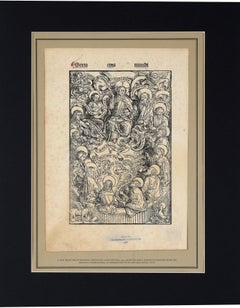
Jesus and the Disciples - Leaflet from the 1497 'Pirate' Nuremberg Chronicles
Located in Soquel, CA
Jesus and the Disciples - Leaflet from the 1497 'Pirate' Nuremberg Chronicles.
The Nuremberg Chronicles were first published in 1493 by Anton Koberger. Following the success of the ...
Category
Impressionist 15th Century and Earlier More Prints
Materials
Rag Paper, Etching
H 18 in W 14 in D 0.25 in
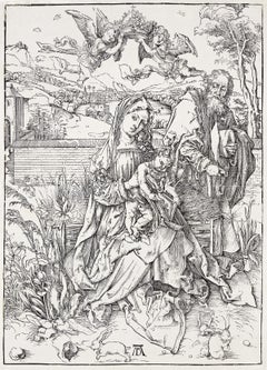
The Holy Family with the Three Hares
Located in New York, NY
A very good, evenly-printed Meder h impression of this woodcut. Strong contrasts and the breaks in the border line but with less wear in the subject.
Category
Northern Renaissance 15th Century and Earlier More Prints
Materials
Woodcut
Wave Of Distress Shepard Fairey Print Obey Giant World Water Day Sephia Gold Pop
Located in Draper, UT
"World Water Day is Monday and is a fitting day to precede the release of these Wave of Distress prints. World Water Day not only focuses attention on the water crisis and drinking w...
Category
Pop Art 15th Century and Earlier More Prints
Materials
Gold
Charles V
By Daniel Hopfer
Located in Brecon, Powys
A Daniel Hopfer portrait engraving of the young Charles V. An exceptionally rare example of the second state struck in the 17th century with the added numera...
Category
15th Century and Earlier More Prints
Materials
Etching
Recently Viewed
View AllMore Ways To Browse
Ewan David Eason
Florida Vintage Travel Posters
Goodyear Poster
Gustav Klutsis
Ihap Hulusi
Ivan Navarro
James B Painter
James Bond Movie Posters
Jan V Roy Posters
John Lennon On Sale
Lait Pur Sterilize
Lake District Vintage Travel Poster
Land Rover Poster
Le Frou Frou Vintage Poster
Leon De Pas
Leon Wuidar
Lillian Snelling
Man Ray Electro Magie
