Items Similar to Map of Denmark, 1724


Want more images or videos?
Request additional images or videos from the seller
1 of 8
UnknownMap of Denmark, 17241724
1724
$460
£360.21
€408.33
CA$662.07
A$722.74
CHF 379.84
MX$8,768.11
NOK 4,789.91
SEK 4,492.45
DKK 3,048.23
About the Item
Extraordinary copper engraved map of Denmark by cartographer Christoph Weigel from 1724. Shows counties, rivers and towns. Ornate title cartouche. Original hand-color. Over 250 years old.
Original antique map displayed on a white mat with a gold border and fits a standard-size frame. Archival plastic sleeve and Certificate of Authenticity included. Map, 14.75"H x 18"W; mat, 18"H x 24"W.
- Creation Year:1724
- Dimensions:Height: 18 in (45.72 cm)Width: 24 in (60.96 cm)Depth: 0.1 in (2.54 mm)
- Medium:
- Period:
- Condition:center fold as issued.
- Gallery Location:Houston, TX
- Reference Number:Seller: 5833K1stDibs: LU10421529873
About the Seller
5.0
Platinum Seller
Premium sellers with a 4.7+ rating and 24-hour response times
Established in 2001
1stDibs seller since 2015
1,071 sales on 1stDibs
Typical response time: 1 hour
- ShippingRetrieving quote...Shipping from: Houston, TX
- Return Policy
Authenticity Guarantee
In the unlikely event there’s an issue with an item’s authenticity, contact us within 1 year for a full refund. DetailsMoney-Back Guarantee
If your item is not as described, is damaged in transit, or does not arrive, contact us within 7 days for a full refund. Details24-Hour Cancellation
You have a 24-hour grace period in which to reconsider your purchase, with no questions asked.Vetted Professional Sellers
Our world-class sellers must adhere to strict standards for service and quality, maintaining the integrity of our listings.Price-Match Guarantee
If you find that a seller listed the same item for a lower price elsewhere, we’ll match it.Trusted Global Delivery
Our best-in-class carrier network provides specialized shipping options worldwide, including custom delivery.More From This Seller
View AllMap of Europe, 1844
Located in Houston, TX
Over 150 year old engraved map of Europe by Olney from 1844. Original hand color. Shows Northern Europe, Prussia and Germany.
Original antique map o...
Category
1840s More Prints
Materials
Ink, Watercolor, Handmade Paper

Ancient World Map
Located in Houston, TX
Over 150 year old engraved map of the world as it was known during the antiquities by cartographer Delamarche from 1838. Original hand color. Shows African, European and Asian cont...
Category
1830s More Prints
Materials
Ink, Watercolor, Handmade Paper
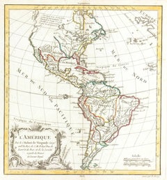
Map of Americas
Located in Houston, TX
Over 200 year old engraved map of Americas by Robert de Vaugondy from 1783. Original hand color. Shows North, Central and South Americas. Note the po...
Category
1780s More Prints
Materials
Ink, Watercolor, Handmade Paper
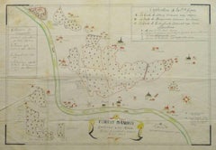
Antique Manuscript Map - Forest of Andely
Located in Houston, TX
Charming hand drawn ink and watercolor map of the Forest of Andely, in the Normandy area, France, circa 1890.
Original artwork on paper displayed on...
Category
1890s More Art
Materials
Ink, Paper, Watercolor
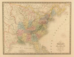
United States, 1844
Located in Houston, TX
Over 150 year old map of early United States of America with Western Districts from 1844. Original hand color. Districts shown include Hurons, Sioux, Mandans, Osages, and Ozark. Note independent Republic of Texas...
Category
1840s More Prints
Materials
Ink, Watercolor, Handmade Paper
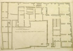
Antique Italian Engraving - Cardinal Este Palace
By Giovanni Giacomo de Rossi
Located in Houston, TX
Over 350 year old antique copper engraving of the floor plan to the Palace of Cardinal Este located in Tivoli, Italy by Italian Giovanni Giacomo de Rossi, 1650.
Original artwork on ...
Category
15th Century and Earlier Interior Prints
Materials
Paper, Ink
$250 Sale Price
50% Off
You May Also Like
Antique Map of Denmark with Details of Fortresses, Cities, Towns Etc, c.1680
Located in Langweer, NL
Antique map of Denmark titled 'Insularum Danicarum ut Zee-Landiae, Fioniae, Langelandiae, Lalandiae Falstriae, Fembriae, Monae (..)'. This map depicts the main Danish Islands and a s...
Category
Antique 17th Century Maps
Materials
Paper

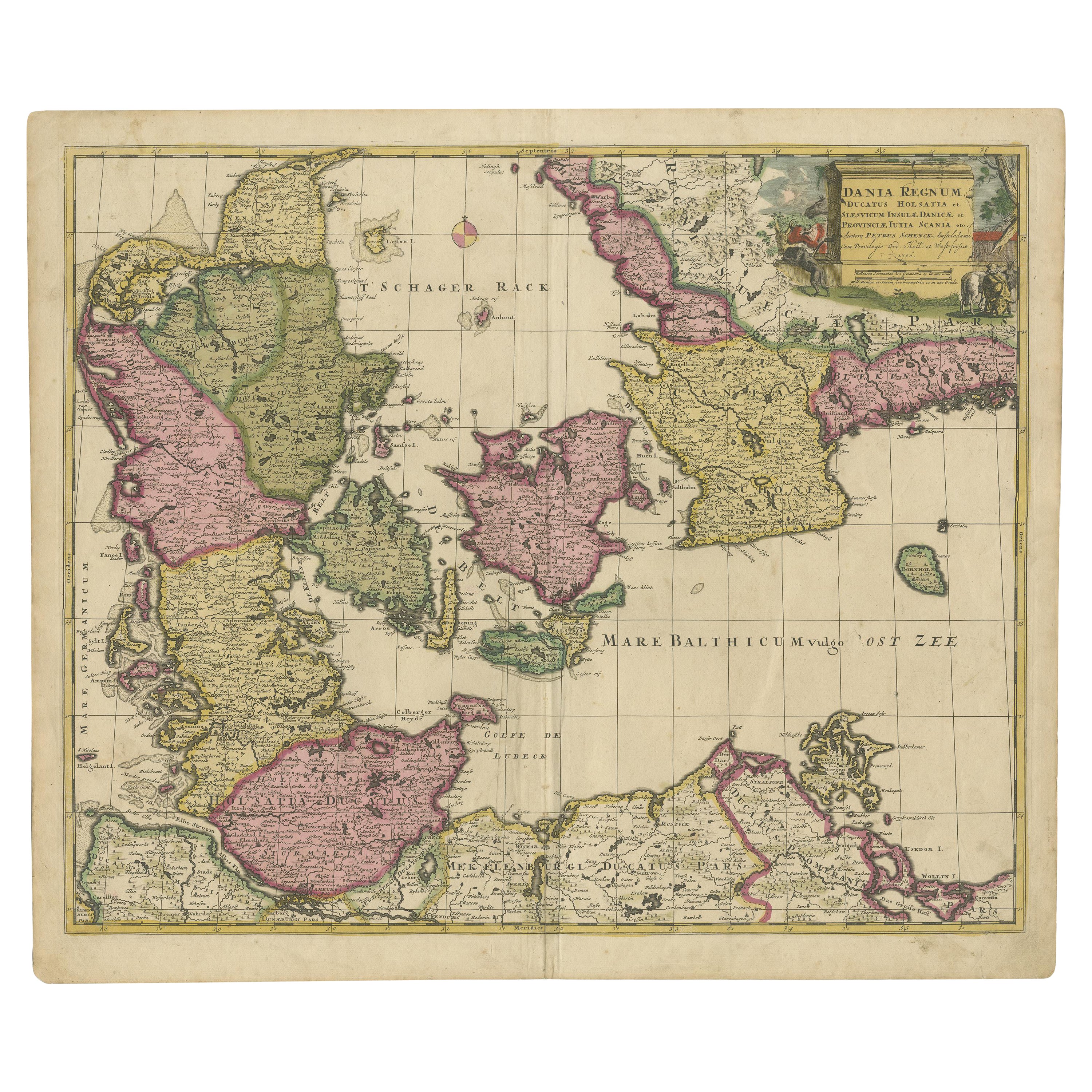
Early 18th Century Map of Denmark in Old Coloring, Published in 1706
Located in Langweer, NL
Denmark. Schenk (Petrus), Dania Regnum Ducatus Holsatia. et Slesvicum Insulae Danicae et Provinciae Jutia Scania etc. Amsterdam, 1706, engraved reticulated map on thick paper with co...
Category
Antique Early 1700s Maps
Materials
Paper
$680 Sale Price
20% Off
Antique Map of Denmark by F. de Wit, 1680
Located in Langweer, NL
Antique map titled 'Dania Regnum'. Large, attractive map of Denmark, Sleschwig-Holstein and southern Sweden. Good detail throughout. Embellished with a title cartouche with the Danis...
Category
Antique Late 17th Century Maps
Materials
Paper

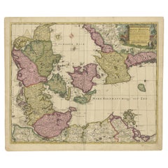
Antique Map of Denmark with Schleswig-Holstein and the South of Sweden, c.1750
Located in Langweer, NL
Antique map titled 'General Charte von Konigreich Daenemark nebst dem Herzogthum Holstein.' Denmark with Schleswig-Holstein and the southern coast of Sweden. The large title cartouch...
Category
Antique 18th Century Maps
Materials
Paper

Map of Denmark Divided into Dioceses – G. & L. Valk, ca. 1690
Located in Langweer, NL
Map of Denmark Divided into Dioceses – G. & L. Valk, ca. 1700
Detailed antique map titled "Regnum Daniae, divisum in Dioeceses Arhusiam, Albergum, Viborgum, et Ripam," showing Denma...
Category
Antique Late 17th Century Maps
Materials
Paper

$515 Sale Price
20% Off
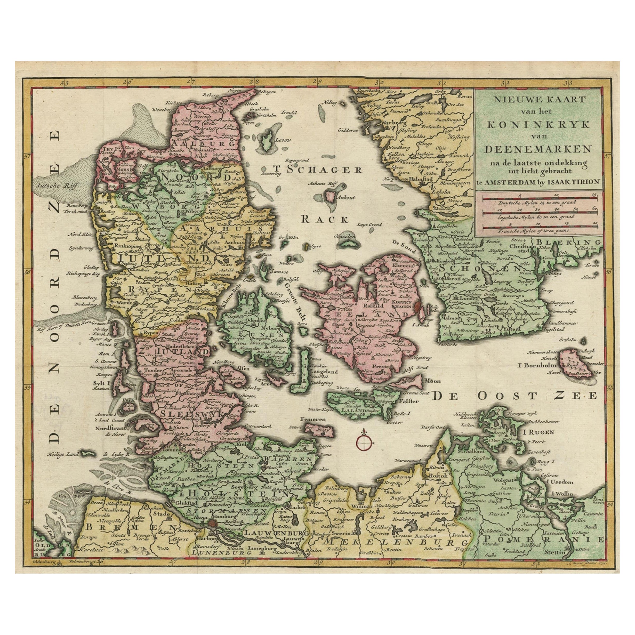
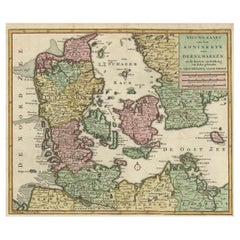
Attractive Antique Map showing Denmark and part of Sweden and Germany c.1750
By Isaak Tirion
Located in Langweer, NL
Antique map titled 'Nieuwe Kaart van het Koninkryk van Deenemarken (..).' Attractive detailed map showing Denmark and a part of Sweden and Germany. Title in block-style cartouche wit...
Category
Antique 18th Century Maps
Materials
Paper
More Ways To Browse
Denmark Map
Antique Map Denmark
17th Century Danish
Deborah Kass Oy
Dig For Victory Poster
Dirty Funker
Goddess Of Liberty
Hamburg Amerika Linie
Infantry Poster
John Lennon Self Portrait
Lithograph Pasta
Lovely Day For A Guinness
Martin Peikert Vintage Posters
Mason Storm
Mel Bochner Blah Blah Blah
Mens Fashion Poster
Nadav Kander
Norway Land Of The Midnight Sun Poster