1836 New Map Of Texas
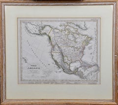
North America: A Framed Hand-colored 19th Century German Map by Adolph Stieler
By Adolf Stieler
Located in Alamo, CA
, Arizona, New Mexico and much of Texas are still part of Mexico. The "Oregon District" includes the modern
Category
1830s Landscape Prints
Materials
Engraving
H 19.5 in W 22 in D 0.88 in
People Also Browsed
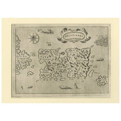
Early Map of Puerto Rico Printed in Venice by G. F. Camocio in 1571
Located in Langweer, NL
Title: S.Giovanni
Publication Info: Venice
Date: 1572
Place created: Venice
Marvelous example of Porcacchi's map of the Island of Puerto Rico. One of the earliest obtainable maps of...
Category
Antique 16th Century Maps
Materials
Paper
Free Shipping
H 4.34 in W 5.91 in D 0.01 in
Original Antique Map of Spain and Portugal, circa 1790
Located in St Annes, Lancashire
Super map of Spain and Portugal
Copper plate engraving by A. Bell
Published, circa 1790.
Unframed.
Category
Antique 1790s English Other Maps
Materials
Paper
America’s First “Spirit God” Ancestor
Located in South Burlington, VT
Pre-Columbian, Hispaniola, Arawak Peoples, Taino Native Indians, early 20th century or older
This is an ancestor sculpture from the Arawak Peoples of the Greater Antilles Islands....
Category
Early 20th Century American Pre-Columbian Native American Objects
Materials
Stone
1817 Map of Puerto Rico and the Virgin Islands with Original Hand Coloring
Located in Langweer, NL
The title provided for this map is "Porto Rico and Virgin Isles," and it is an antique map from an early 19th century atlas, dated 1817, featuring original hand coloring. This histor...
Category
Antique Early 19th Century Maps
Materials
Paper
Free Shipping
H 25.99 in W 11.03 in D 0 in
Engraving by Tallis and Rapkin of Map of the West Indies in The Caribbean, 1851
Located in Langweer, NL
John Tallis' 1851 map of the West Indies stands as a striking example of his renowned cartographic work. With meticulous detail and artistic embellishments, this map offers a compreh...
Category
Antique Mid-19th Century Maps
Materials
Paper
H 10.44 in W 14.57 in D 0 in
18th Century French Louis XVI Giltwood Console Table with Inset Onyx Top
Located in Miami, FL
18th century French Louis XVI giltwood console table with inset onyx top
Offered for sale is a rare and fine quality late 18th century giltwood console table with inset onyx top t...
Category
Antique Late 18th Century French Louis XVI Console Tables
Materials
Onyx, Bronze
Antique Map of the Antilles by Meyer, 1878
Located in Langweer, NL
Antique map titled 'Die Antillen'. Old map of the Antilles, it shows Jamaica, Puerto Rico, the Bahamas and Cuba. With inset maps of the Lesser Antilles and Havana. This map originate...
Category
Antique 19th Century Maps
Materials
Paper
Small globe h. 6.5 of late 1800s by cartographer Ludw. Jul. Heymann
Located in Milan, IT
Small globe published in the second half of the 19th century by cartographer Ludw. Jul. Heymann. Papier maché ball and turned and ebonized wood base.
Height cm 16,- inches 6.5, sphe...
Category
Antique Late 19th Century Globes
Materials
Paper
Green Space Ceiling Lamp by Dovain Studio
Located in Geneve, CH
Green Space ceiling lamp by Dovain Studio.
Dimensions: H 100 x W 105 x D 50 cm.
Materials: Lacquered Metal, Brass detail
Dovain Studio
Creative direction by Sergio Prieto, a Sp...
Category
2010s Portuguese Post-Modern Chandeliers and Pendants
Materials
Metal, Brass
Antique Print of a Nurse/Sister and Child in Madrid by Lallemand, circa 1840
Located in Langweer, NL
Antique print titled 'Nourrice à Madrid'. No. 114 from 'Musée Cosmopolite'. This print originates from a section illustrating costumes of Spain and Portugal.
Category
Antique Mid-19th Century Prints
Materials
Paper
H 10.95 in W 8.39 in D 0.02 in
Pair of Monumental Sculpted Panels from the Eighteenth Century
Located in Madrid, ES
PAIR OF MONUMENTAL CARVED PANELS FROM THE 18TH CENTURY
IMPORTANT SPANISH BAROQUE 18TH CENTURY WOODEN PANELS ATTRIBUTED TO: Luis Bonifás y Massó-Valls, 1730 - Valls, 1786) was a Span...
Category
Antique 18th Century Decorative Art
Materials
Fruitwood
St. Christophe (St. Kitts): Bellin 18th Century Hand Colored Map
Located in Alamo, CA
Jacques Bellin's copper-plate map of the Caribbean island of Saint Kitts entitled "Carte De De l'Isle St. Christophe Pour servir á l'Histoire Genle. des Voyages Par M. B. Ingr. de la...
Category
1740s Other Art Style Landscape Prints
Materials
Engraving
Rare Wood, Patinated Iron and Gilded Bronze Dedicated Column, 1896
Located in PARIS, FR
A rare wood column adorned with patinated iron and gilt bronze ornaments. It relies on four bronze feet and is topped with a foliate bronze capital with caduceus. A bronze band is ci...
Category
Antique 1890s Pedestals and Columns
Materials
Bronze, Iron
Antique Map of the Islands of Schiatti and Scopoli, Greece, 1687
Located in Langweer, NL
Antique map titled 'Schiatti - Scopoli.' This original antique map shows the islands Schiatti and Scopoli in Greece. Source unknown, to be determined.
Artists and Engravers: Made by...
Category
Antique 17th Century Maps
Materials
Paper
First Edition Guthrie's Geographical Grammmar in Miniature, 1807
Located in Langweer, NL
First edition of 'Guthrie's Geographical Grammar in Miniature'. 358 p. 13 fold. engr. maps, contemp. calf. Gilt spine. sm. 8vo. Upper hinge showing but strong; old bookplate "Ex Bibl...
Category
Antique Early 19th Century Books
Materials
Paper
Large Antique Map of Ancient Spain and Portugal, Published in circa 1760
Located in Langweer, NL
Antique map titled 'Hispania Antiqua (..)'. Map of ancient Spain and Portugal. Engraved by G. Delahaye. Published circa 1760, by or after Sanson & Vaugondy.
Category
Antique Mid-18th Century Maps
Materials
Paper
No Reserve
H 20.16 in W 26.86 in D 0.02 in
Recent Sales
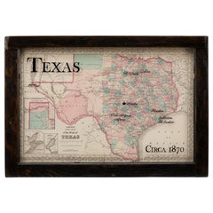
1870 Texas Map by Colton
Located in Colorado Springs, CO
This is a highly detailed map of Texas, colored by counties and showing the early County
Category
Antique 1870s American Maps
Get Updated with New Arrivals
Save "1836 New Map Of Texas", and we’ll notify you when there are new listings in this category.
More Ways To Browse
Antique Map Of Cuba
Antique Maps Of Cuba
Antique Arizona Map
Dominican Republic Map
Republic Of Texas Map
Antique Maps San Diego
United States Civil War Map
Antique Cuba Map
Cuba Antique Map
Northern Pacific Railroad
Discount Universe
Landscape Jamaica
Cuban Plates
Mexican Frame Maps
Maps Mexico Frame
Antique Maps Of New Mexico
Antique Jamaica Map
Antique Map Of Jamaica


