Timeless Intaglio

to
1
301
282
212
202
100
89
51
51
50
41
37
33
26
24
21
20
15
12
10
10
10
9
8
7
7
7
6
5
5
5
5
4
4
3
3
2
2
2
2
2
1
1
1
1
1
1
74
40
37
31
16
Kee-She-Waa, A Fox Warrior: Hand-colored McKenney & Hall Folio-sized Lithograph
By McKenney & Hall
Located in Alamo, CA
This an original 19th century hand-colored folio-size McKenney and Hall engraving of a Native American entitled "Kee-She-Waa, A Fox Warrior", drawn b...
Category

Mid-19th Century Naturalistic Portrait Prints

Materials

Engraving

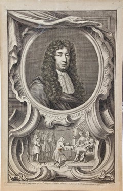
18th Century Engraved Portrait of George Savile, Marquis of Halifax by Houbraken
By Jacobus Houbraken 1
Located in Alamo, CA
A superb 18th century engraved portrait of George Savile, Marquis of Halifax, Plate 82 in "The Heads of Illustrious Persons of Great Britain", written by...
Category

Mid-18th Century Realist Portrait Prints

Materials

Laid Paper, Engraving

Views of London: A Pair of Framed 19th Century Engravings by Havell and Allom
Located in Alamo, CA
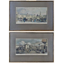
This is a pair of framed hand-colored prints, both utilizing engraving and etching techniques, depicting two London architectural landmarks: "The National Gallery, Charing Cross" and "Covent Garden Market" from the Stationers' Almanac, published in London by J. Robins & Sons in the early 19th century. Both of these prints show vibrant London street scenes with markets, carriages, common people as well as the wealthy in the foreground of "Covent Garden Market" and wealthy well dressed people, carriages, a begger, street merchants, as well as uniformed military on horseback in the foreground of "The National Gallery". "The National Gallery, Charing Cross" was created by James Sands from a painting by Thomas Allom (1804-1872), published in 1836. "Covent Garden Market" was created by Frederick James Havell (1801–1840/41) after a painting by William Havell...
Category

Mid-19th Century Naturalistic Landscape Prints

Materials

Engraving, Etching

The Heidelberg Tun: A Framed 17th Century Engraving of a Huge Wine Cask
Located in Alamo, CA
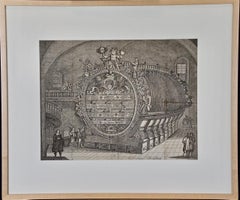
"The Heidelberg Tun" is a 17th century engraving by an unknown artist. It depicts a famous huge ornamental wine cask that resided in the wine cellar of Heidelberg Castle. The cask shown here, built in 1664, is the second of four Heidelberg Tuns; the first was destroyed during the Thirty Years' War, between 1618 and 1648. This cask was built in 1664 when Karl Ludwig ordered Heidelberg cellar master...
Category

Late 17th Century Old Masters Interior Prints

Materials

Engraving

A Portrait of a Pensive Woman in a Head Scarf: An Etching by George Rhead
Located in Alamo, CA
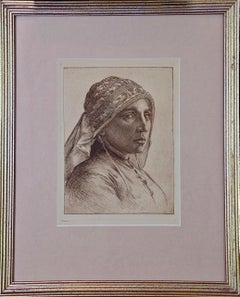
This is an etched portrait of a pensive woman wearing a detailed cloth head scarf by George Woolliscroft Rhead (1854-1920). It may be entitled "A Fisher Wife", but this can not be co...
Category

Late 19th Century Old Masters Portrait Prints

Materials

Etching

Daniel Marot's The Siege of the Dutch Fortified City of Ypres by Louis XIV
By Daniel Marot
Located in Alamo, CA
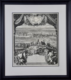
"Ypres, Grand Ville Riche & Marchande" is an engraving and etching by Daniel Marot (le Vieux) (1661–1752). It depicts a view of the siege of the city of Ypres and its citadel on the left in the Spanish Netherlands by Louis XIV's troops. This battle took place between March 18 and March 25, 1678, as part of the Franco-Dutch War. Marot illustrated in great detail (best appreciated with magnification) the French attack on the strong pentagonal citadel on the extreme left, which had been built recently in anticipation of a French attack. The trenches built by the French approaching the town are seen on the right. King Louis XIV can be seen in the foreground surveying the battle mounted on his white horse, surrounded by his officers and troops. The print is presented in an attractive ornate black wood frame with a cream-colored double mat with a black inner trim. It is glazed with plexiglas. The frame measures 25.38" x 22.63" x .88". The engraving, frame, mat and glazing are in excellent condition. Artist: Daniel Marot (1661–1752) was also called "Le Vieux". He was the son of the famous architect, Jean Marot. Marot had diverse interests and talents. In addition to his art, he designed garden projects, architectural ornaments, furniture, and even upholstery. Marot as a Huguenot protestant was forced to leave France in 1685 following the revocation of the Edict of Nantes. He emigrated to Holland, where he worked for William of Orange (an arch enemy of his former employer Louis XIV). Marot was largely responsible for the interiors of Williams palace at the Loo. In 1694 he went Britain as William had married Queen Mary and he had become King William III of England. He later returned to Holland in about 1698 and died in the Hague in 1752. He left a lasting legacy on the decorative arts in the Netherlands, where his grand version of the Louis XIV style remained popular into the 1730s. Historical Background: In October 1677, Mary Stuart, niece and possible successor of Charles II of England, married Louis XIV's arch enemy William III of Orange...
Category

Late 17th Century Old Masters Landscape Prints

Materials

Engraving, Etching

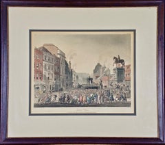
"Pillory, Charing Cross" by Rowlandson from "The Microcosm of London"
By Thomas Rowlandson
Located in Alamo, CA
"Pillory, Charing Cross" is an illustration (Plate 62) from "The Microcosm of London", published in London in 1809 by R Ackermann's Repository of Arts. The scene was created by one of the most famous British satirists and caricaturists of the late 18th and early 19th centuries' Georgian Period, Thomas Rowlandson, who drew the figures, while Augustus Charles Pugin drew the architecture. The plate was then created by Hill, Stadler and Bluck using a combination of aquatint and etching and was then hand colored with watercolor. Scenes illustrated in "The Microcosm of London" gives an accurate and often comical view of everyday life in London during the Regency Period of the early 19th century. While Pugin’s excellent architectural drawings capture the size and shape of the exterior as well as the interior of London’s principal buildings, Thomas Rowlandson’s insightful and often whimsical and satirical view of the city's inhabitants depicts the color and vitality of the late Georgian society, both rich and poor alike. This print depicts the "Pillory, Charing Cross", where criminals were brought and placed on display while secure in the stocks, as are seen in this print. A crowd is present in the square jeering at the prisoners. A statue of Charles I on horseback stands atop a very large pillar to the right. Shops with apartments are seen on the left. Young wealthy people frolic around and on a carriage on the right in front of the statue of King...
Category

Early 1800s Other Art Style Landscape Prints

Materials

Etching, Aquatint

A Set of Two Hand-Colored Engravings of an Ancient Roman Vase and a Tazza (Cup)
Located in Alamo, CA
This is a pair of framed hand-colored engravings of an ancient vase in the Palizzy Wares style and a silver gilt tazza (cup) with a cover, both from the 16th century. These were engraved under the supervision of Philip De La Motte...
Category

Mid-19th Century Victorian Still-life Prints

Materials

Engraving

"Mordon Colledge (the original spelling) Black Heath" from Universal Magazine
Located in Alamo, CA
This beautiful hand-colored copper-plate engraving entitled "The West Prospect of Mordon Colledge (Old English Spelling) Black Heath" was published in the 'The Universal Magazine...
Category

Mid-18th Century Naturalistic Landscape Prints

Materials

Engraving

"Northern Meadow Mouse" an Audubon Hand Colored by J.T. Bowen Lithograph
By John James Audubon
Located in Alamo, CA
An original 19th century John James Audubon hand colored lithograph entitled "Northern Meadow Mouse", No. 26, Plate CXXIX, 129, from Audubon's "Quadrupeds of North America", printed ...
Category

Mid-19th Century Naturalistic Animal Prints

Materials

Lithograph

Muse Terpsichore: Framed Hand-colored 19th C. Engraving after 17th C. Painting
Located in Alamo, CA
"Dessine par Gallier" is a hand-colored engraving and etching by Pierre Laurent (1739-1809) and Pierre Audouin (1768-1822) after a painting by Eustache Le Sueur...
Category

Late 18th Century Romantic Figurative Prints

Materials

Engraving, Etching

Tillotson, Archbishop of Canterbury: An 18th C. Hand-Colored Portrait by Kneller
By (After) Sir Godfrey Kneller
Located in Alamo, CA
This is a hand-colored portrait of John Tillotson, Archbishop of Canterbury, engraved and etched by the Dutch master of portraits Jacobus Houb...
Category

Mid-18th Century Naturalistic Portrait Prints

Materials

Engraving, Etching

An Antique Engraved View of "Waterfalls in Smoland", Sweden by Erik Dahlberg
By Erik Dahlberg
Located in Alamo, CA
This is an antique engraved view entitled "Delineatio Cataractae" (Waterfalls in Smoland), Sweden in 1705 from "Sueciae Antiquae et Hodiernae"' published in Stockholm by Erik Dahlber...
Category

Early 18th Century Naturalistic Landscape Prints

Materials

Laid Paper, Engraving

An Antique Engraved View of "Romelborg", Sweden in the 17th C. by Erik Dahlberg
By Erik Dahlberg
Located in Alamo, CA
An antique engraved view of "Romelborg", Sweden in 1705 from "Sueciae Antiquae et Hodiernae"' published in Stockholm by Erik Dahlberg (1625-1703). The engraving was created by Johan...
Category

Early 18th Century Naturalistic Landscape Prints

Materials

Laid Paper, Engraving

Viscount Thomas Belasise: 17th Century Hand-colored Portrait by Robert White
Located in Alamo, CA
This is a hand-colored engraving by Robert White (1645-1703) after a painting by Abraham Blooteling (or Bloteling) (1634–1690) entitled "The Effigies of the Right honorable: Thomas B...
Category

Late 17th Century Other Art Style Portrait Prints

Materials

Engraving

Vanity Fair Caricature, Rev. Edgar Sheppard "A Great Marrier" by Spy
By Sir Leslie Ward
Located in Alamo, CA
Vanity Fair color chromolithograph caricature of Rev. Edgar Sheppard "A Great Marrier" by Spy (Leslie Ward) March 14, 1904 from the "Clergymen" series....
Category

Late 19th Century Victorian Portrait Prints

Materials

Lithograph
Rip Van Winkle by Washington Irving and Illustrated by Arthur Rackham
By Arthur Rackham
Located in Alamo, CA
"Rip Van Winkle" by Washington Irving was published in New York in 1905 by Doubleday, Page & Co./William Heinemann. It was illustrated by Arthur Rackham. It contains fifty-one full-p...
Category

Early 20th Century English Books

Materials

Leather, Paper

The Rhinegold and the Valkyrie, Limited Ed. Illustrated and Signed by A. Rackham
By Arthur Rackham
Located in Alamo, CA
"The Rhinegold and the Valkyrie" by Richard Wagner and translated into English by Margaret Armour was published in London in 1910 by Doubleday, Page & Co./William Heinemann. It conta...
Category

Early 20th Century English Books

Materials

Leather, Paper

The Ring of the Niblung by Richard Wagner, Illustrated by Arthur Rackham
By Arthur Rackham
Located in Alamo, CA
"The Ring of the Niblung", "The Rhinegold: Prelude; The Valkyrie: First Day of the Trilogy; Siegfried: Second Day of the Trilogy; The Twilight of the Gods: Third Day of the Trilogy" ...
Category

Early 20th Century English Books

Materials

Leather, Paper

Peter Pan in Kensington Gardens
By Arthur Rackham
Located in Alamo, CA
"Peter Pan in Kensington Gardens" by J. M. Barrie was published in 1909 by Hodder & Stoughton. It was illustrated by Arthur Rackham. It contains fifty full-page color illustrations m...
Category

Early 20th Century English Books

Materials

Paper, Leather

The Arthur Rackham Fairy Book, A Deluxe Limited Edition, Signed by Rackham
By Arthur Rackham
Located in Alamo, CA
"The Arthur Rackham Fairy Book, A Book of Old Favorites with New Illustrations" was published in 1933 by George Harrap & Co. Ltd. It is one of the last books illustrated by Arthur Ra...
Category

Mid-20th Century English Books

Materials

Paper

England, Scotland & Ireland: A Hand Colored Map of Great Britain by Tirion
By Isaak Tirion
Located in Alamo, CA
This is a hand-colored double page copperplate map of Great Britain entitled "Nieuwe Kaart van de Eilanden van Groot Brittannien Behelzende de Kon...
Category

Antique Mid-18th Century Dutch Maps

Materials

Paper

The Holy Land at the Time of Jesus: A 17th Century Dutch Map by Visscher
By Nicolaes Visscher II
Located in Alamo, CA
This detailed Dutch map entitled "Het Beloofe de Landt Canaan door wandelt van onsen Salichmaecker Iesu Christo, nessens syne Apostelen" by Nicolaes Visscher was published in Amsterd...
Category

Antique Mid-17th Century Dutch Maps

Materials

Paper

Plymouth, England: A Hand-Colored 17th Century Sea Chart by Captain Collins
By Captain Greenvile Collins
Located in Alamo, CA
This hand-colored sea chart of the area around Plymouth, England from "Great Britain's Coasting Pilot. Being a New and Exact Survey of the Sea-Coast of England", first published in 1...
Category

Antique Late 17th Century English Maps

Materials

Paper

Flanders, Holland & Norfolk: Hand-Colored 17th Century Sea Chart by Collins
By Captain Greenvile Collins
Located in Alamo, CA
This hand-colored chart of the seas about Flanders, Holland, Frisia, and Norfolk is from "Great Britain's Coasting Pilot. Being a New and Exact Survey of the Sea-Coast of England" by...
Category

Antique Late 17th Century English Maps

Materials

Paper

Edinburgh, Scotland Coast: A 17th Century Hand-Colored Sea Chart by Collins
By Captain Greenvile Collins
Located in Alamo, CA
This hand-colored sea chart is entitled "Edinburgh Firth" from "Great Britain's Coasting Pilot. Being a New and Exact Survey of the Sea-Coast of England" by Captain Greenville Collin...
Category

Antique Late 17th Century English Maps

Materials

Paper

Dartmouth, England: A Hand-Colored 17th Century Sea Chart by Captain Collins
By Captain Greenvile Collins
Located in Alamo, CA
This hand-colored sea chart of the area around Dartmouth, England is from "Great Britain's Coasting Pilot. Being a New and Exact Survey of the Sea-Coast of England", first published ...
Category

Antique Late 17th Century English Maps

Materials

Paper

Captain Cook's Exploration of Tahiti 18th C. Hand-Colored Map by Bellin
By Jacques-Nicolas Bellin
Located in Alamo, CA
This beautiful 18th century hand-colored copper plate engraved map is entitled "Carte de l'Isle de Taiti, par le Lieutenant J. Cook" was created by Jacques Nicolas Bellin and publish...
Category

Antique Mid-18th Century French Maps

Materials

Paper

"Africa Vetus": a 17th Century Hand-Colored Map by Sanson
By Nicolas Sanson
Located in Alamo, CA
This original hand-colored copperplate engraved map of Africa entitled "Africa Vetus, Nicolai Sanson Christianiss Galliar Regis Geographi" was originally created by Nicholas Sanson d...
Category

Antique Late 17th Century French Maps

Materials

Paper

City View of Nuremberg, Germany: An 18th Century Hand-Colored Map by M. Seutter
By Matthew Seutter
Located in Alamo, CA
An 18th century hand-colored city view of Nuremburg, Germany entitled "Geometrischer Grundris der des Heiligen Römischen Reichs Freyen Stadt Nürnberg" by Matthaus Seutter from his "A...
Category

Antique Mid-18th Century German Maps

Materials

Paper

Hand-Colored 18th Century Homann Map of the Danube, Italy, Greece, Croatia
By Johann Baptist Homann
Located in Alamo, CA
"Fluviorum in Europa principis Danubii" is a hand colored map of the region about the Danube river created by Johann Baptist Homann (1663-1724) in his 'Atlas Novus Terrarum', publish...
Category

Antique Early 18th Century German Maps

Materials

Paper

The Kingdom of Naples and Southern Italy: A Hand-Colored 18th Century Homann Map
By Johann Baptist Homann
Located in Alamo, CA
"Novissima & exactissimus Totius Regni Neapolis Tabula Presentis Belli Satui Accommo Data" is a hand colored map of southern Italy and the ancient Kingdom of Naples created by Johann...
Category

Antique Early 18th Century German Maps

Materials

Paper

California, Alaska and Mexico: 18th Century Hand-Colored Map by de Vaugondy
By Didier Robert de Vaugondy
Located in Alamo, CA
This an 18th century hand-colored map of the western portions of North America entitled "Carte de la Californie et des Pays Nord-Ouest separés de l'Asie par le détroit d'Anian, extra...
Category

Antique 1770s French Maps

Materials

Paper

North & South America: A 17th Century Hand-colored Map by Jansson & Goos
By Johannes Janssonius
Located in Alamo, CA
A 17th century hand-colored map of North & South America entitled "Americae Descriptio" by the cartographer Johannes Jansson, published in Jansson's Atlas Minor in Amsterdam in 1628....
Category

Antique 1620s Dutch Maps

Materials

Paper

Southern & Eastern Europe: A Large 17th C. Hand-colored Map by Sanson & Jaillot
By Nicolas Sanson
Located in Alamo, CA
This large hand-colored map entitled "Estats de L'Empire des Turqs en Europe, ou sont les Beglerbeglicz our Gouvernements" was originally created by Nicholas Sanson d'Abbeville and t...
Category

Antique 1690s French Maps

Materials

Paper

Vienna, Austria: A Large 17th Century Hand-Colored Map by Sanson and Jaillot
By Nicolas Sanson
Located in Alamo, CA
This large 17th century hand-colored map of Vienna, Austria and the surrounding countryside and villages entitled "Plan de la Ville de Vienne en Austrich...
Category

Antique 1690s French Maps

Materials

Paper

Portugal: A Large 17th Century Hand-colored Map by Sanson and Jaillot
By Nicolas Sanson
Located in Alamo, CA
This large hand-colored map entitled "Le Royaume de Portugal et des Algarves Divisee en see Archeveches, Eveches et Territoires Par le Sr Sanson" was originally created by Nicholas S...
Category

Antique 1690s French Maps

Materials

Paper

Southern Greece: A Large 17th C. Hand-colored Map by Sanson and Jaillot
By Nicolas Sanson
Located in Alamo, CA
This large original hand-colored copperplate engraved map of southern Greece and the Pelopponese Peninsula entitled "La Moree Et Les Isles De Zante, Cefalonie, Ste. Marie, Cerigo & C...
Category

Antique 1690s French Maps

Materials

Paper

Africa: A Large 17th Century Hand-Colored Map by Sanson and Jaillot
By Nicolas Sanson
Located in Alamo, CA
This large original hand-colored copperplate engraved map of Africa entitled "L'Afrique divisee suivant l'estendue de ses principales parties ou sont distingues les uns des autres, L...
Category

Antique 1690s French Maps

Materials

Paper

The Normandy Region of France: A 17th C. Hand-colored Map by Sanson and Jaillot
By Nicolas Sanson
Located in Alamo, CA
This large hand-colored map entitled "Le Duché et Gouvernement de Normandie divisée en Haute et Basse Normandie en divers Pays; et par evêchez, avec le Gouvernement General du Havre ...
Category

Antique 1690s French Maps

Materials

Paper

West Africa Entitled "Guinea Propria": An 18th Century Hand Colored Homann Map
By Johann Baptist Homann
Located in Alamo, CA
This is a scarce richly hand colored copper plate engraved map of Africa entitled "Guinea Propria, nec non Nigritiae vel Terrae Nigrorum Maxima Pars" by Johann Baptist Homann (1664-1...
Category

Antique Mid-18th Century German Maps

Materials

Paper

Persia, Armenia & Adjacent Regions: A 17th Century Hand-colored Map by De Wit
By Frederick de Wit
Located in Alamo, CA
A large 17th century hand colored copperplate engraved map entitled "Novissima nec non Perfectissima Scandinaviae Tabula comprehendens Regnorum Sueciae, Daniae et Norvegiae distincte...
Category

Antique Late 17th Century Dutch Maps

Materials

Paper

Northern Scotland: A 17th Century Hand-colored Map by Mercator
By Gerard Mercator
Located in Alamo, CA
This is a framed hand-colored 17th century map of Northern Scotland by Gerard Mercator entitled "Scotiae pars Septentrionalis", published in Amsterdam in 1636. It is a highly detailed map of the northern part of Scotland, with the northwest Highlands and the cities Inverness and Aberdeen, as well as the Orkney Islands and the Hebrides. There is a decorative title cartouche in the upper left corner. The map is presented in an antiqued brown wood...
Category

Antique 1630s Dutch Maps

Materials

Paper

Northern Scotland: A 16th Century Hand-colored Map by Mercator
By Gerard Mercator
Located in Alamo, CA
A framed hand-colored 16th century map of Northern Scotland by Gerard Mercator entitled "Scotiae pars Septentrionalis", published in Amsterdam in 1636. It is a highly detailed map of the northern part of Scotland, with the northwest Highlands and the cities Inverness and Aberdeen, as well as the Orkney Islands and the Hebrides. There is a decorative title cartouche in the upper left corner. The map is presented in an antiqued brown wood...
Category

Antique 16th Century Dutch Maps

Materials

Paper

Scandinavia & Portions of Eastern Europe: 18th Century Hand-Colored Homann Map
By Johann Baptist Homann
Located in Alamo, CA
An early 18th century hand-colored copper-plate map entitled "Regni Sueciae in omnes suas Subjacentes Provincias accurate divisi Tabula Generalis" by Johann Baptist Homann (1663-1724...
Category

Antique Early 18th Century German Maps

Materials

Paper

St. Christophe 'St. Kitts' Island: An 18th Century Hand-colored Map by Bellin
By Jacques-Nicolas Bellin
Located in Alamo, CA
Jacques Bellin's copper-plate map of the Caribbean island of Saint Kitts entitled "Carte De De l'Isle St. Christophe Pour servir á l'Histoire Genle. des V...
Category

Antique Mid-18th Century French Maps

Materials

Paper

West Coast of Africa, Guinea & Sierra Leone: An 18th Century Map by Bellin
By Jacques-Nicolas Bellin
Located in Alamo, CA
Jacques Bellin's copper-plate map entitled "Partie de la Coste de Guinee Dupuis la Riviere de Sierra Leona Jusquau Cap das Palmas", depicting the coast of Guinea and Sierra Leone in ...
Category

Antique Mid-18th Century French Maps

Materials

Paper

Sweden & Adjacent Portions of Scandinavia: A Hand-Colored 18th C. Map by Homann
By Johann Baptist Homann
Located in Alamo, CA
This hand-colored map of Sweden and adjacent portions of Scandinavia entitled "Regni Sueciae in Omnes suas Subjacentes Provincias accurate divisi Tabula Generalis" was created by Joh...
Category

Antique 1720s German Maps

Materials

Paper

America "Amérique Septentrionale": A 19th Century French Map by Delamarche
By Maison Delamarche 1
Located in Alamo, CA
This framed mid 19th century map of North America entitled "Amérique Septentrionale" by Felix Delamarche was published in Paris in 1854 by Quay de l'Horloge du Palais, avec les Carte...
Category

Antique Mid-19th Century American Other Maps

Materials

Paper

Southeastern Ireland: A 17th Century Hand Colored Map by Mercator and Hondius
By Gerard Mercator
Located in Alamo, CA
A 17th century copperplate hand-colored map entitled "The Second Table of Ireland, Udrone" by Gerard Mercator and Jodocus Hondius, published in Amsterdam in 1635 in 'Cosmographicall ...
Category

Antique Mid-17th Century Dutch Maps

Materials

Paper

17th Century Hand-Colored Map of Southeastern England by Mercator and Hondius
By Gerard Mercator
Located in Alamo, CA
A 17th century copperplate hand-colored map entitled "The Sixt Table of England" by Gerard Mercator and Jodocus Hondius, published in Amsterdam in 1635 in 'Cosmographicall Descriptio...
Category

Antique Mid-17th Century Dutch Maps

Materials

Paper

"Nova Barbariae Descriptio", a 17th Century Hand-Colored Map of North Africa
By Johannes Janssonius
Located in Alamo, CA
This original attractive 17th century hand-colored map of North Africa entitled "Nova Barbariae Descriptio" by Johannes Janssonius was published in Paris in 1635. It includes the Med...
Category

Antique Mid-17th Century Dutch Maps

Materials

Paper

Hand-Colored 18th Century Homann Map of the Black Sea, Turkey and Asia Minor
By Johann Baptist Homann
Located in Alamo, CA
An attractive original early 18th century hand-colored map of the Black Sea and Turkey entitled "Carte de L'Asie Minevre ou de la Natolie et du Pont Evxin Tiree des Voyages et des Ob...
Category

Antique Early 18th Century German Maps

Materials

Paper

18th Century Hand-Colored Homann Map of Germany, Including Frankfurt and Berlin
By Johann Baptist Homann
Located in Alamo, CA
An 18th century hand-colored map entitled "Tabula Marchionatus Brandenburgici et Ducatus Pomeraniae quae sunt Pars Septentrionalis Circuli Saxoniae Superioris" by Johann Baptist Homa...
Category

Antique Early 18th Century German Maps

Materials

Paper

Hand-Colored 18th Century Homann Map of Denmark and Islands in the Baltic Sea
By Johann Baptist Homann
Located in Alamo, CA
An 18th century copper plate hand-colored map entitled "Insulae Danicae in Mari Balthico Sitae utpote Zeelandia, Fionia, Langelandia, Lalandia, Falstria, Fembria Mona" created by Joh...
Category

Antique Early 18th Century German Maps

Materials

Paper

Greece, "Graeciae Antiquae"" A 17th Century Hand-colored Map by Sanson
By Nicolas Sanson
Located in Alamo, CA
This is an original 17th century hand colored copperplate engraved map of Greece entitled "Graeciae Antiquae Tabula Hanc Geographicam" by Nicolas d'Abbeville Sanson, engraved and pub...
Category

Antique Mid-17th Century French Maps

Materials

Paper

17th Century Hand Colored Map of the Liege Region in Belgium by Visscher
By Nicolaes Visscher II
Located in Alamo, CA
An original 17th century map entitled "Leodiensis Episcopatus in omnes Subjacentes Provincias distincté divisusVisscher, Leodiensis Episcopatus" by Nicolaes Visscher II, published in Amsterdam in 1688. The map is centered on Liege, Belgium, includes the area between Antwerp, Turnhout, Roermond, Cologne, Trier and Dinant. This attractive map is presented in a cream-colored mat measuring 30" wide x 27.5" high. There is a central fold, as issued. There is minimal spotting in the upper margin and a tiny spot in the right lower margin, which are under the mat. The map is otherwise in excellent condition. The Visscher family were one of the great cartographic families of the 17th century. Begun by Claes Jansz Visscher...
Category

Antique Late 17th Century Dutch Maps

Materials

Paper

18th Century Hand Colored Map of Spain and Portugal by Visscher
By Nicolaes Visscher II
Located in Alamo, CA
This is an early 18th century map of Spain and Portugal, with attractive original hand-coloring, entitled "Hispaniae et Portugalliae Regna per Nicolaum Visscher cum Privilegio Ordinu...
Category

Antique Early 18th Century Dutch Maps

Materials

Paper

17th Century Hand-Colored Map of a Region in West Germany by Janssonius
By Johannes Janssonius
Located in Alamo, CA
This attractive highly detailed 17th century original hand-colored map is entitled "Archiepiscopatus Maghdeburgensis et Anhaltinus Ducatus cum terris adjacentibus". It was published ...
Category

Antique Mid-17th Century Dutch Maps

Materials

Paper

Map of the Holy Land "Carte de la Syrie et de l'Egypte" by Pierre M. Lapie
By Pierre M. Lapie
Located in Alamo, CA
An early 19th century map of ancient Syria and Egypt entitled "Carte de la Syrie et de l'Egypte anciennes/dressée par M. Lapie, Colonel d'Etat Major, et...
Category

Antique Early 19th Century French Maps

Materials

Paper

Recently Viewed

View All