Items Similar to North America: A Framed Hand-colored 19th Century German Map by Adolph Stieler


Want more images or videos?
Request additional images or videos from the seller
1 of 13
Adolf StielerNorth America: A Framed Hand-colored 19th Century German Map by Adolph Stieler1832
1832
About the Item
This framed early 19th century map of North America entitled "Nord-Amerika" is plate No. LIV (No. 46) from Adolph Stieler's Hand-Atlas, published in Gotha, Germany by Justus Perthes in 1832. The original title of the publication was 'Hand-Atlas über alle Theile der Erde und über das Weltgebäude' (Handy Atlas of all Parts of the World and of the Universe).
The map depicts eastern portions of Russia and the adjacent Aleutian Islands and Alaska which are identified as Russian territories. California, Arizona, New Mexico and much of Texas are still part of Mexico. The "Oregon District" includes the modern day state of Washington. Much of the central portions of the United States are identified as Native American regions such as The Sioux District, The Mandan District, The Ozark District, The Huron District and The Osage District. The map does include Canada, Mexico, Central America, Cuba, Jamaica, Haiti, Santa Domingo (the Dominican Republic) , the West Indies and portions of Greenland and South America. Along the California coast, Mendocino, Monterrey, Santa Barbara, San Diego, Santa Catalina Island are identified, San Francisco and Los Angeles were not included.
The map is hand-colored in outline. It is presented in a light brown distressed bleached wood frame with a cream-colored mat. The frame measures 19.5" high x 22" wide x 0.88" deep. There is a central vertical fold, as issued. The map is in very good condition. The mat is somewhat toned.
There are two other 19th century maps of North America (the United States and one including Mexico) listed on 1stdibs that are presented in identical style frames and mats. They can be seen by entering their reference #'s (LU5206222080792 or LULU5206221574182) in the search field. These would make an interesting and attractive grouping. A discount is available for purchase of a grouping of two or three of these maps.
Adolf Stieler (1775-1836) was a German cartographer and lawyer. He was the main cartographer in Justus Perthes' Geographical Institute in Gotha, Germany. He served in the German government for his entire career, but maintained an interest in cartography and published many prominent works, including his Hand-Atlas, which was the leading German world atlas until the middle of the 20th century.
About the Seller
5.0
Platinum Seller
Premium sellers with a 4.7+ rating and 24-hour response times
Established in 2011
1stDibs seller since 2019
283 sales on 1stDibs
Typical response time: 2 hours
- ShippingRetrieving quote...Shipping from: Alamo, CA
- Return Policy
Authenticity Guarantee
In the unlikely event there’s an issue with an item’s authenticity, contact us within 1 year for a full refund. DetailsMoney-Back Guarantee
If your item is not as described, is damaged in transit, or does not arrive, contact us within 7 days for a full refund. Details24-Hour Cancellation
You have a 24-hour grace period in which to reconsider your purchase, with no questions asked.Vetted Professional Sellers
Our world-class sellers must adhere to strict standards for service and quality, maintaining the integrity of our listings.Price-Match Guarantee
If you find that a seller listed the same item for a lower price elsewhere, we’ll match it.Trusted Global Delivery
Our best-in-class carrier network provides specialized shipping options worldwide, including custom delivery.More From This Seller
View AllL'Isle de France: A Hand-colored 17th Century Map by De Wit
By Frederick de Wit
Located in Alamo, CA
This colorful and detailed 17th century hand-colored copperplate map by Frederick De Wit was published in Amsterdam between 1666 and 1760. The map depicts the Île-de-France, which is one of the ancient provinces of France. Paris is located in the center of the map, with Versailles to the southwest The map extends from Rouen in the west to Reims in the east. The area around Paris, the Véxin Français, was the original domain of the king of France. Other areas were ruled by French feudal lords. For example, the Véxin Normand area was the domain of the Duke of Normandy...
Category
Early 18th Century Old Masters More Prints
Materials
Engraving

Fever Nut Plant "Ban Caretti": A 17th Century Engraving by Hendrik van Rheede
Located in Alamo, CA
This is a 17th century engraving of a fever or bonduc nut plant entitled "Ban Caretti" by Hendrik van Rheede tot Drakenstein, plate 20 from his 'Hortus Indi...
Category
Late 17th Century Naturalistic Landscape Prints
Materials
Engraving
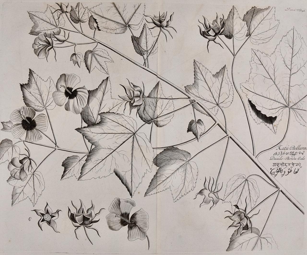
"Katu-Belluren": A 17th Century Botanical Engraving by Hendrik van Rheede
Located in Alamo, CA
This is a 17th century engraving of a vine spinach plant entitled "Katu-Belluren" by Hendrik van Rheede tot Drakenstein, plate 46 from his 'Hortus Indicus M...
Category
Late 17th Century Naturalistic Landscape Prints
Materials
Engraving
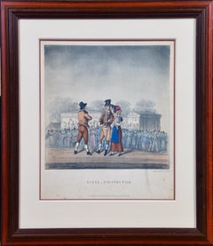
"Scene _ Country Fair": A Framed Early 19th Century Engraving by George Hunt
By George Hunt
Located in Alamo, CA
This is a framed colored engraving entitled "Scene _ Country Fair" by George Hunt, published in London in 1825. It depicts a gathering of people at an early 19th century county fair, presumably in England. A majority of the crowd are turned away, watching a performance on a stage in the background. In the foreground a man is in conversation with a couple. The man wears a top hat and the woman is holding a baby. They are dressed in the typical attire of the middle class at that time.
The engraving is presented in a brown wood frame and a double mat, with a cream-colored outer mat and a light cranberry...
Category
Early 19th Century Landscape Prints
Materials
Engraving
A Greenfinch & A Sparrow: An 18th Century Hand-colored Engraving by Martinet
By François Nicolas Martinet
Located in Alamo, CA
This is a hand-colored engraving of a Greenfinch bird and a tree sparrow ("1, Le Friquet, 2. Le Verdier") by Francois Nicolas Martinet, plate 227 from 'Histoire Naturelle des Oiseaux...
Category
1760s Naturalistic Animal Prints
Materials
Engraving

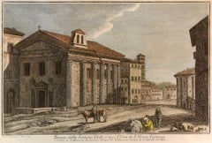
View of Emden, Germany: A 16th Century Hand-colored Map by Braun & Hogenberg
By Franz Hogenberg
Located in Alamo, CA
This is a 16th century original hand-colored copperplate engraved map of a bird's-eye View of Embden, Germany entitled " Emuda, vulgo Embden vrbs Frisia orientalis primaria" by Georg Braun & Franz Hogenberg, in volume II of their famous city atlas "Civitates Orbis Terrarum", published in Cologne, Germany in 1575.
This is a beautifully colored and detailed map of Emden, a seaport in northwestern Germany, along the Ems River and perhaps portions of over Dollart Bay, near the border with the Netherland. The map depicts a bird's-eye view of the city from the southwest, as well as a view of the harbor and an extensive system of canals. Numerous ships of various sizes, as well as two rowboats containing numerous occupants are seen in the main waterway in the foreground and additional boats line two canals in the center of the city. Two men and two women are shown on a hill in the foreground on the right, dressed in the 16th century style of nobility. Two ornate crests are included in each corner. A title strap-work cartouche is in the upper center with the title in Latin. The crest on the right including Engelke up de Muer (The Little Angel on the Wall) was granted by Emperor Maximilian I in 1495.
This is an English translation of an excerpt of Braun's description of Embden: "In Emden, the capital of East Frisia, rich merchants live in very fine houses. The city has a broad and well-situated harbour, which in my opinion is unique in Holland. Frisia and the whole of the Netherlands, for the ships can anchor here right under the city walls. They have also extended the harbour as far as the New Town, so that up to 400 ships can now find shelter here when the sea is rough."
The emphasis on the harbor and waterways within the city highlights the importance of Emden's place as a seaport at this time. Embden developed from a Dutch/Flemish trading settlement in the 7th-8th centuries into a city as late as late 14th century. In 1494 it was granted staple rights, and in 1536 the harbour was extended. In the mid-16th century Emden's port was thought to have the most ships in Europe. Its population then was about 5,000, rising to 15,000 by the end of the 16th century. The Ems River flowed directly under the city walls, but its course was changed in the 17th century by the construction of a canal. Emden has canals within its city limits, a typical feature of Dutch towns, which also enabled the extension of the harbor. In 1744 Emden was annexed by Prussia and is now part of Germany. It was captured by French forces in 1757 during the Seven Years' War, but recaptured by Anglo-German forces in 1758. During the Napoleonic French era, Emden and the surrounding lands of East Frisia were part of the short-lived Kingdom of Holland.
References:Van der Krogt 4, 1230, State 2; Taschen, Braun and Hogenberg...
Category
16th Century Old Masters Landscape Prints
Materials
Engraving

You May Also Like
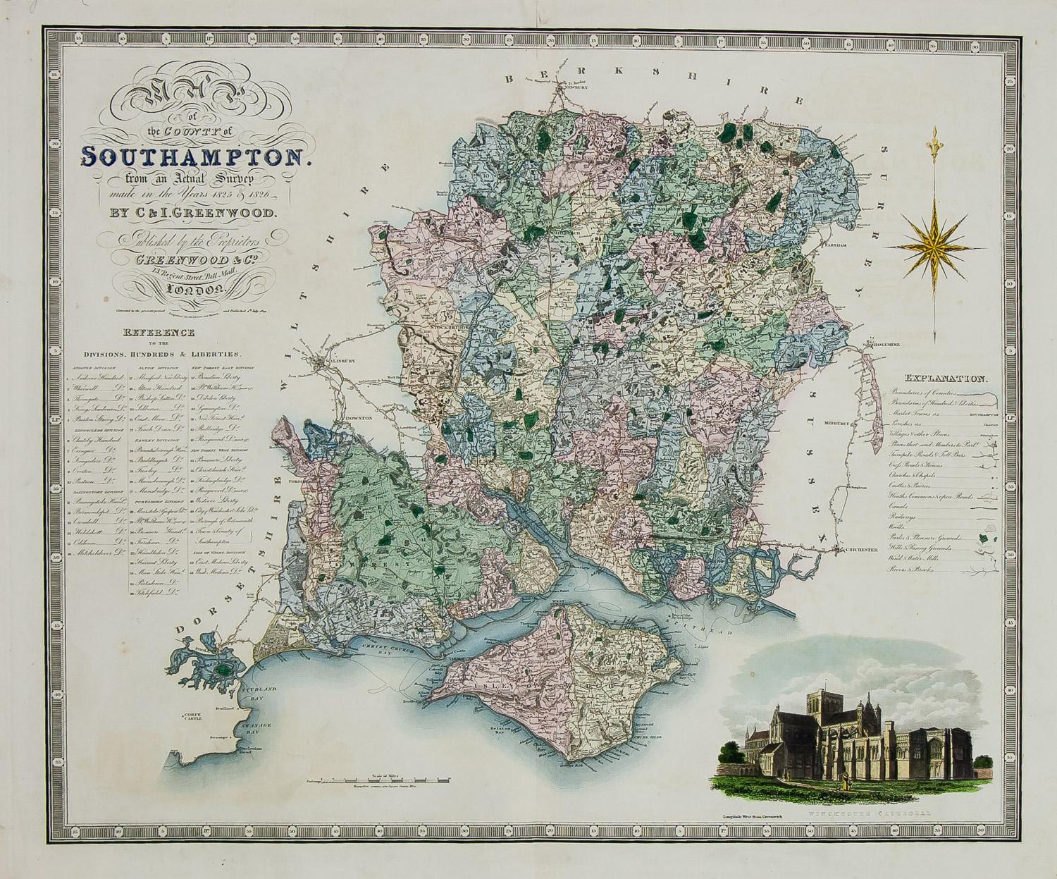
England Map of the County of Southampton from an Actual Survey
Located in Paonia, CO
Cartographers Christopher (1786-1855) and John (1791-1867) Greenwood were surveyors from Yorkshire, who undertook an ambitious project to produce a series of large-scale maps of the counties of England, Wales and Scotland.The maps represent a remarkable and impressive surveying achievement forming an important record of the counties depicted.
In the years 1817-1832 the Greenwood brothers published the Atlas of The Counties of England from an Actual Survey. This Atlas was finely drafted and engraved and decorated with large vignettes of prominent buildings of the county. This map of Southampton County is beautifully hand colored and is in very good condition. There is a vignette of Winchester Cathedral...
Category
19th Century Other Art Style Landscape Prints
Materials
Engraving

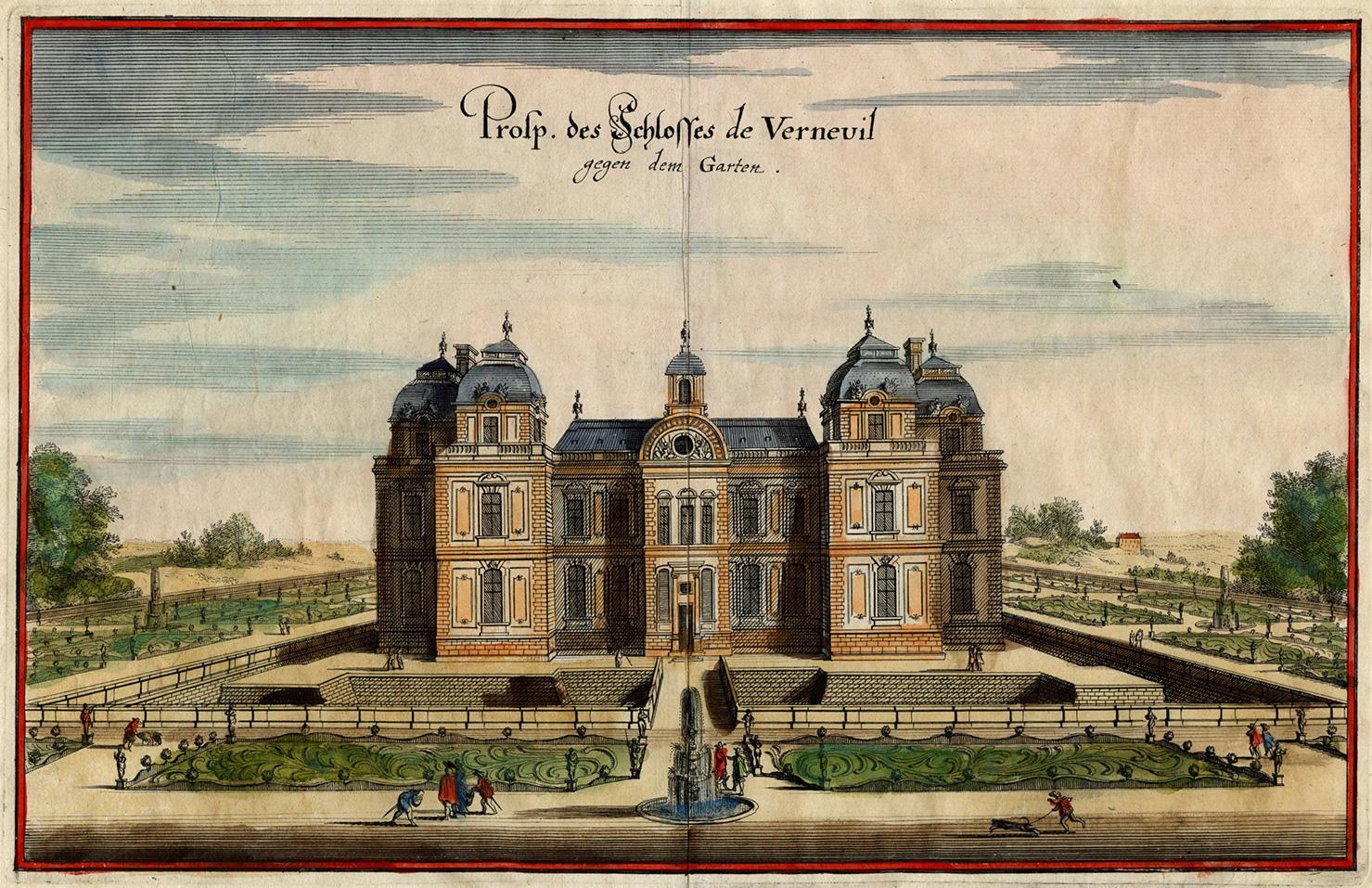
Chateau de Verneuil
By Matthäus Merian the Elder
Located in Middletown, NY
Engraving with hand coloring and heightening in watercolor on two leaves of expertly conjoined handmade laid paper, one leaf with a large watermark a feathered dragon, 7 1/4 x 11 1/4...
Category
Mid-17th Century Old Masters Landscape Prints
Materials
Watercolor, Handmade Paper, Engraving

Veduta del Tempio della Fortuna Virile, from Raccolta delle più belle Vedute ...
By Giuseppe Vasi
Located in Middletown, NY
By Giuseppe Vasi after Giovanni Piranesi: Etching and engraving with hand coloring in watercolor on laid paper with an E and R watermark, full margins. Minor...
Category
Late 18th Century Old Masters Landscape Prints
Materials
Watercolor, Laid Paper, Engraving, Etching
Ocean Terminal I
By Craig McPherson
Located in New Orleans, LA
Craig McPherson captures a night view of the neon lights from commercial signs reflected in the water at Ocean Terminal in Kowloon, as seen from the terminal of the Star Ferry to cen...
Category
1990s Contemporary Landscape Prints
Materials
Mezzotint

White Monday
By Martin Lewis
Located in Fairlawn, OH
Signed in the plate lower left
Note: Printed on September 26, 1980 in an edition of 4 restrikes.
Reference: Paul McCarron, The Prints of Martin Lewis: A Catalogue Raisonne (Bro...
Category
1970s Landscape Prints
Materials
Drypoint
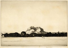
The Acropolis, Athens
By Louis Conrad Rosenberg
Located in Middletown, NY
Etching and drypoint on cream wove paper, full margins. Signed in pencil, lower right margin. In generally good conditon with several scattered very light spots of foxing throughout,...
Category
1920s Modern Landscape Prints
Materials
Handmade Paper, Drypoint, Etching
Recently Viewed
View AllMore Ways To Browse
Antique Native American Prints
Antique Maps Of North America
Early 19th Century Mexican
Antique Oregon
Cuba Plate
Antiques From Mexico
Antique Map Mexico
Antique Maps California
West Indies Map
Antique Maps Of Canada
California Island Map
Antique Maps West Indies
Cuban Antiques
Map Of Mexican California
Middle Eastern Antiques
Antique Maps Of Texas
West Indies Antiques
Map Of Jamaica