Items Similar to Antique Map of Martinique, Showing Roads, Houses, Sugar Plantations, etc. c.1750


Want more images or videos?
Request additional images or videos from the seller
1 of 5
Antique Map of Martinique, Showing Roads, Houses, Sugar Plantations, etc. c.1750
About the Item
Antique map titled 'Carte de l'Isle de la Martinique'.
Detailed map of Martinique. Shows hilly terrain, forests, roads, houses, and even the sugar plantations. The island was to the French what Barbados and Jamaica were to the English: immensely profitable sites for sugar production. Artists and Engravers: Jean (Johannes) Covens and Corneille (Cornelius) Mortier were brothers-in-law, who carried on the book publishing business established by Pierre Mortier in Amsterdam in 1685. Pierre Mortier's company owed much of its success to his access to French publishers, whose publications he re-issued in handsome editions.The elder Mortier died in 1711; his wife continued the firm until she died in 1719. In 1721, Covens and Mortier formed a partnership, Covens having married Agatha Mortier in the same year. They continued the business by publishing enlarged editions of Sanson, Jaillot, and De L'Isle, as well as some of the later Dutch cartographical masters such as De Wit and Allard, and of course Pierre Mortier.
Artist: Jean (Johannes) Covens and Corneille (Cornelius) Mortier were brothers-in-law, who carried on the book publishing business established by Pierre Mortier in Amsterdam in 1685. Pierre Mortier's company owed much of its success to his access to French publishers, whose publications he re-issued in handsome editions.The elder Mortier died in 1711; his wife continued the firm until she died in 1719. In 1721, Covens and Mortier formed a partnership, Covens having married Agatha Mortier in the same year. They continued the business by publishing enlarged editions of Sanson, Jaillot, and De L'Isle, as well as some of the later Dutch cartographical masters such as De Wit and Allard, and of course Pierre Mortier.
Condition: Good, general age-related toning. Repair on folding line. Map number inked at top margin. Please study image carefully.
Date: c.1750
Overall size: 65.5 x 52.5 cm.
Image size: 59 x 45.5 cm.
- Dimensions:Height: 25.79 in (65.5 cm)Width: 20.67 in (52.5 cm)Depth: 0 in (0.01 mm)
- Materials and Techniques:
- Period:
- Date of Manufacture:circa 1750
- Condition:
- Seller Location:Langweer, NL
- Reference Number:
About the Seller
5.0
Platinum Seller
These expertly vetted sellers are 1stDibs' most experienced sellers and are rated highest by our customers.
Established in 2009
1stDibs seller since 2017
1,946 sales on 1stDibs
Typical response time: <1 hour
- ShippingRetrieving quote...Ships From: Langweer, Netherlands
- Return PolicyA return for this item may be initiated within 14 days of delivery.
More From This SellerView All
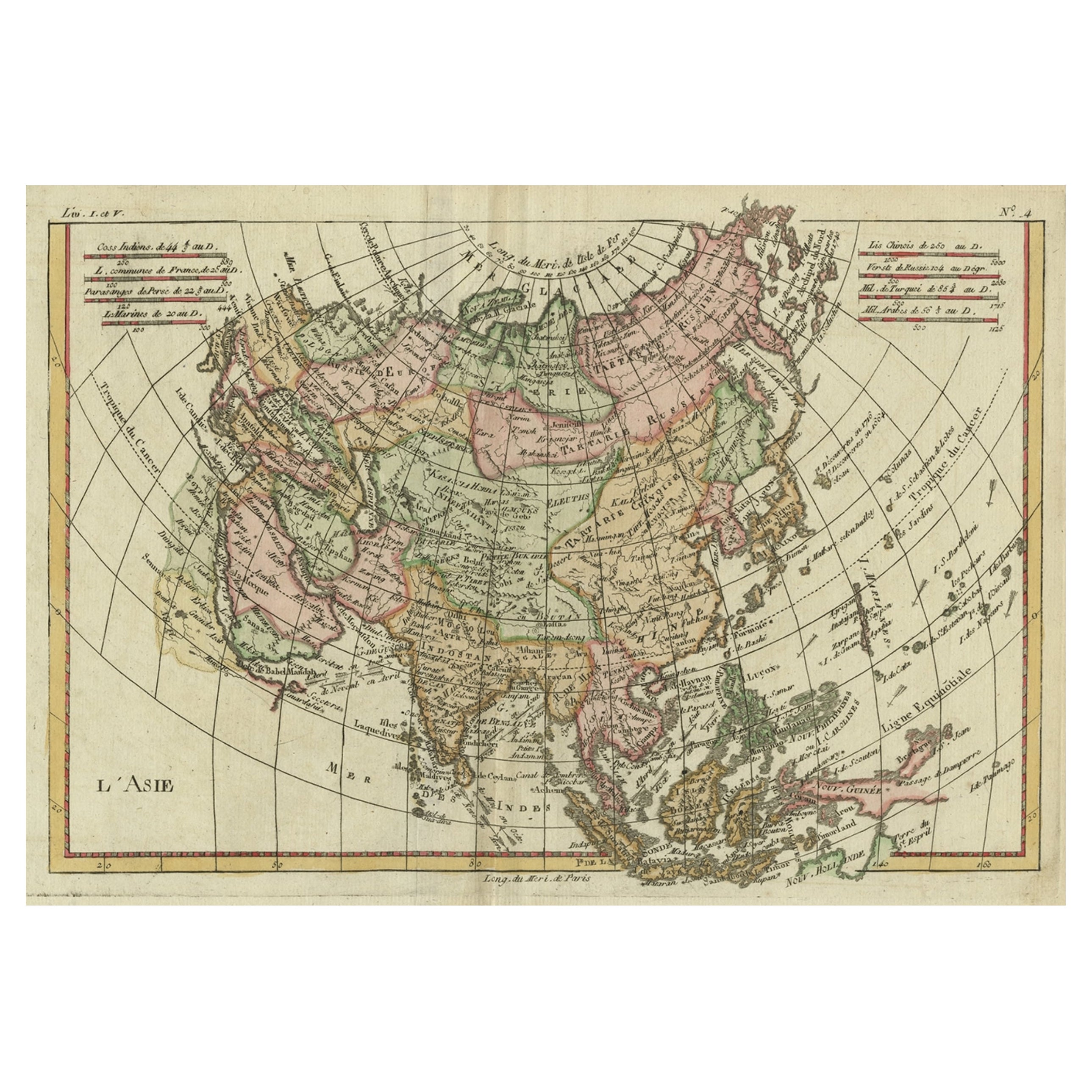
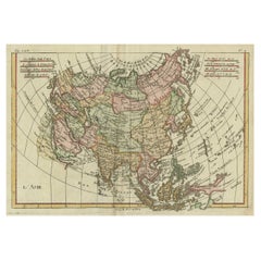
- Antique Map of Asia, Showing Tradewinds, Silke Route Cities Etc, c.1780Located in Langweer, NLAntique map titled 'L'Asie.' Map of Asia. Offers considerable detail considering the size, showing the tradewinds in the Pacific and Indian Oceans as well as numerous Silk Route citi...Category
Antique 18th Century Maps
MaterialsPaper
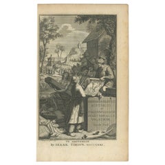
- Antique Frontispiece by Tirion, Showing a Map of Africa, an Elephant Etc, 1731Located in Langweer, NLAntique frontispiece of the 3rd volume of 'Hedendaagsche historie of tegenwoordige staat van allen volkeren (..)' by Thomas Salmon. This volume describes Peg...Category
Antique 18th Century Prints
MaterialsPaper
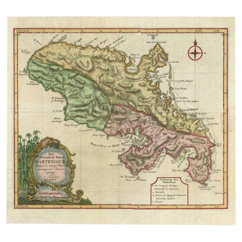
- Antique Map of Martinique with Title Cartouche Garnished with Sugar Cane, c.1760Located in Langweer, NLAntique map titled 'Het Westindisch Eiland Martenique'. Decorative map of Martinique filled with good detail of roads, topography, soundings, villages, windmills, and plantations. Th...Category
Antique 18th Century Maps
MaterialsPaper
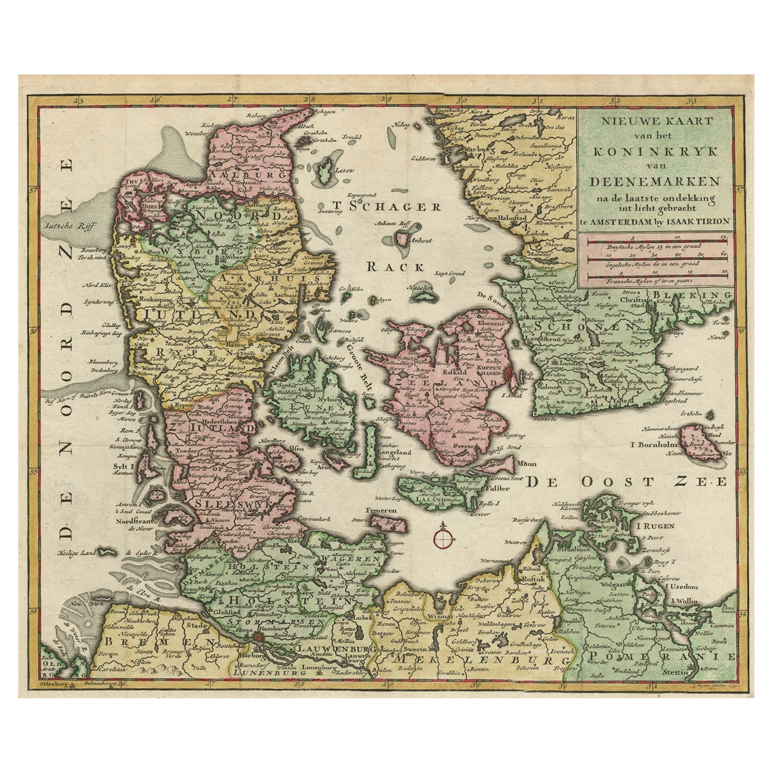
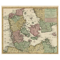
- Attractive Antique Map showing Denmark and part of Sweden and Germany c.1750By Isaak TirionLocated in Langweer, NLAntique map titled 'Nieuwe Kaart van het Koninkryk van Deenemarken (..).' Attractive detailed map showing Denmark and a part of Sweden and Germany. Title in block-style cartouche wit...Category
Antique 18th Century Maps
MaterialsPaper
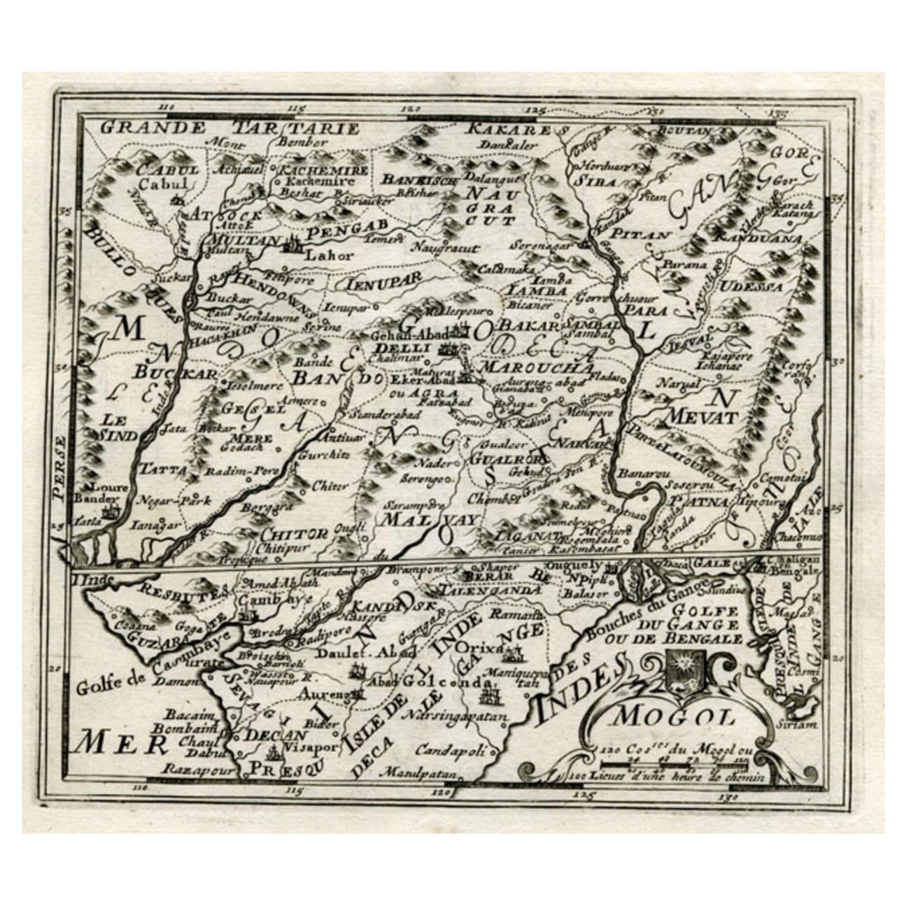
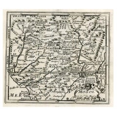
- Map of Northern India and Pakistan 'Mogol', Showing Kabul, Delhi Etc., 1758Located in Langweer, NLAntique map titled 'Mogol'. Map of Northern India and Pakistan ('Mogol'), showing Kabul, Delhi and surroundings. This map originates from 'Kort begrip der Oude en Nieuwe Staatkun...Category
Antique 1750s Maps
MaterialsPaper
- Antique Map of England, Also Showing CalaisLocated in Langweer, NLAntique map titled 'Carte de l'Angleterre pour le Voyage dans les trois Royaumes'. Original old map of England, also showing Calais. This map originates from 'Voyage dans les trois r...Category
Antique Late 18th Century Maps
MaterialsPaper

You May Also Like
- Antique 1901 National Publishing Company's Road Map of New Jersey GeologicalLocated in Dayton, OHThe National Publishing Company's road map of New Jersey, showing all county and township divisions, cities villages and post-offices, railroads, ste...Category
Antique Early 1900s Victorian Prints
MaterialsPaper
- Antique Map of Principality of MonacoBy Antonio Vallardi EditoreLocated in Alessandria, PiemonteST/619 - "Old Geographical Atlas of Italy - Topographic map of ex-Principality of Monaco" - ediz Vallardi - Milano - A somewhat special edition ---Category
Antique Late 19th Century Italian Other Prints
MaterialsPaper
- Prussia, Poland, N. Germany, Etc: A Hand-colored 17th Century Map by JanssoniusBy Johannes JanssoniusLocated in Alamo, CAThis is an attractive hand-colored copperplate engraved 17th century map of Prussia entitled "Prussia Accurate Descripta a Gasparo Henneberg Erlichensi", published in Amsterdam by Joannes Janssonius in 1664. This very detailed map from the golden age of Dutch cartography includes present-day Poland, Latvia, Lithuania, Estonia and portions of Germany. This highly detailed map is embellished by three ornate pink, red, mint green and gold...Category
Antique Mid-17th Century Dutch Maps
MaterialsPaper
- Original Antique Map of Italy. C.1780Located in St Annes, LancashireGreat map of Italy Copper-plate engraving Published C.1780 Unframed.Category
Antique Early 1800s English Georgian Maps
MaterialsPaper

- Original Antique Map of Asia. C.1780Located in St Annes, LancashireGreat map of Asia Copper-plate engraving Published C.1780 Two small worm holes to right side of map Unframed.Category
Antique Early 1800s English Georgian Maps
MaterialsPaper

- Original Antique Map of India. C.1780Located in St Annes, LancashireGreat map of India Copper-plate engraving Published C.1780 Three small worm holes to right side of map and one bottom left corner Unframed.Category
Antique Early 1800s English Georgian Maps
MaterialsPaper


Recently Viewed
View AllMore Ways To Browse
Antique Etc
French Sugar
Plantation Furniture
Road Map
Enlarged French
Used Furniture Jamaica
Cornelius Hollander
Antique Plantation
Antique Plantation Furniture
Corneille Dutch
Antique Furniture Jamaica
Antique Road Maps
Antique Road Map
Barbados Furniture
Mortier Antique
Dutch Plantation
Used Furniture Barbados
Cornelius Company