Items Similar to Antique Map of Northern Italy by Homann Heirs, c.1730


Want more images or videos?
Request additional images or videos from the seller
1 of 6
Antique Map of Northern Italy by Homann Heirs, c.1730
About the Item
Antique map titled 'Domini Veneti cum vicinis Parmae Mutinae, Matuae et Mirandol (..).' Detailed map of northern Italy by J. B. Homann. This map shows Venice and its adjacent states Parma, Modena, Mantua and Mirandol. Large title cartouche, key and scale. Source unknown, to be determined. Artists and Engravers: Made by 'Homann Heirs' after an anonymous artist. Following the long period of Dutch domination, the Homann family became the most important map publishers in Germany in the eighteenth century, the business being founded by J.B. Homann in Nuremberg about the year 1702. Soon after publishing his first atlas in 1707 he became a member of the Berlin academy of Sciences and in 1715 he was appointed Geographer to the Emperor. After the founder's death in 1724, the firm was continued under the direction of his son until 1730 and was then bequeathed to his heirs on the condition that it trades under the name of Homann Heirs. The firm remained in being until the next century and had a wide influence on map publishing in Germany. Apart from the atlases the firm published a very large number of individual maps. The Homanns produced a Neuer Atlas in 1714, a Grosser Atlas in 1737, and an Atlas Maior with about 300 maps in 1780. They also issued a special Atlas of Germany with full sized plans of principal cities, school atlases and an Atlas of Silesia in 1750 with 20 maps.
Artist: Made by 'Homann Heirs' after an anonymous artist. Following the long period of Dutch domination, the Homann family became the most important map publishers in Germany in the eighteenth century, the business being founded by J.B. Homann in Nuremberg about the year 1702. Soon after publishing his first atlas in 1707 he became a member of the Berlin academy of Sciences and in 1715 he was appointed Geographer to the Emperor. After the founder's death in 1724, the firm was continued under the direction of his son until 1730 and was then bequeathed to his heirs on the condition that it trades under the name of Homann Heirs. The firm remained in being until the next century and had a wide influence on map publishing in Germany. Apart from the atlases the firm published a very large number of individual maps. The Homanns produced a Neuer Atlas in 1714, a Grosser Atlas in 1737, and an Atlas Maior with about 300 maps in 1780. They also issued a special Atlas of Germany with full sized plans of principal cities, school atlases and an Atlas of Silesia in 1750 with 20 maps.
Condition: Good, given age. Bottom margin with small repaired tear, extending 2 cm into image. Two small tears top edge, not affecting image. Light staining and soiling in the margins. Light vertical crease right of middle fold. Original middle fold as issued. General age-related toning and/or occasional minor defects from handling. Please study image carefully.
Date: c.1730
Antique prints have long been appreciated for both their aesthetic and investment value. They were the product of engraved, etched or lithographed plates. These plates were handmade out of wood or metal, which required an incredible level of skill, patience and craftsmanship. Whether you have a house with Victorian furniture or more contemporary decor an old engraving can enhance your living space. We offer a wide range of authentic antique prints for any budget.
- Dimensions:Height: 21.07 in (53.5 cm)Width: 24.89 in (63.2 cm)Depth: 0 in (0.01 mm)
- Materials and Techniques:
- Period:
- Date of Manufacture:circa 1730
- Condition:Repaired: Bottom margin with small repaired tear, extending 2 cm into image. Condition: Good, given age. Two small tears top edge, not affecting image. Light staining and soiling in the margins. Light vertical crease right of middle fold.
- Seller Location:Langweer, NL
- Reference Number:
About the Seller
5.0
Platinum Seller
These expertly vetted sellers are 1stDibs' most experienced sellers and are rated highest by our customers.
Established in 2009
1stDibs seller since 2017
1,946 sales on 1stDibs
Typical response time: <1 hour
- ShippingRetrieving quote...Ships From: Langweer, Netherlands
- Return PolicyA return for this item may be initiated within 14 days of delivery.
More From This SellerView All
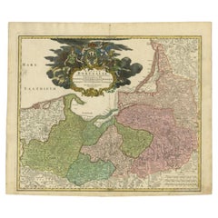
- Antique Map of the Baltic Region by Homann Heirs, c.1730Located in Langweer, NLAntique map titled 'Regnum Borussiae gloriosis auspicijs Seerenissimi et Potentissimi Princip Friderici III (..).' Detailed map of the Baltic region from Memel to Pomerania, extendin...Category
Antique 18th Century Maps
MaterialsPaper
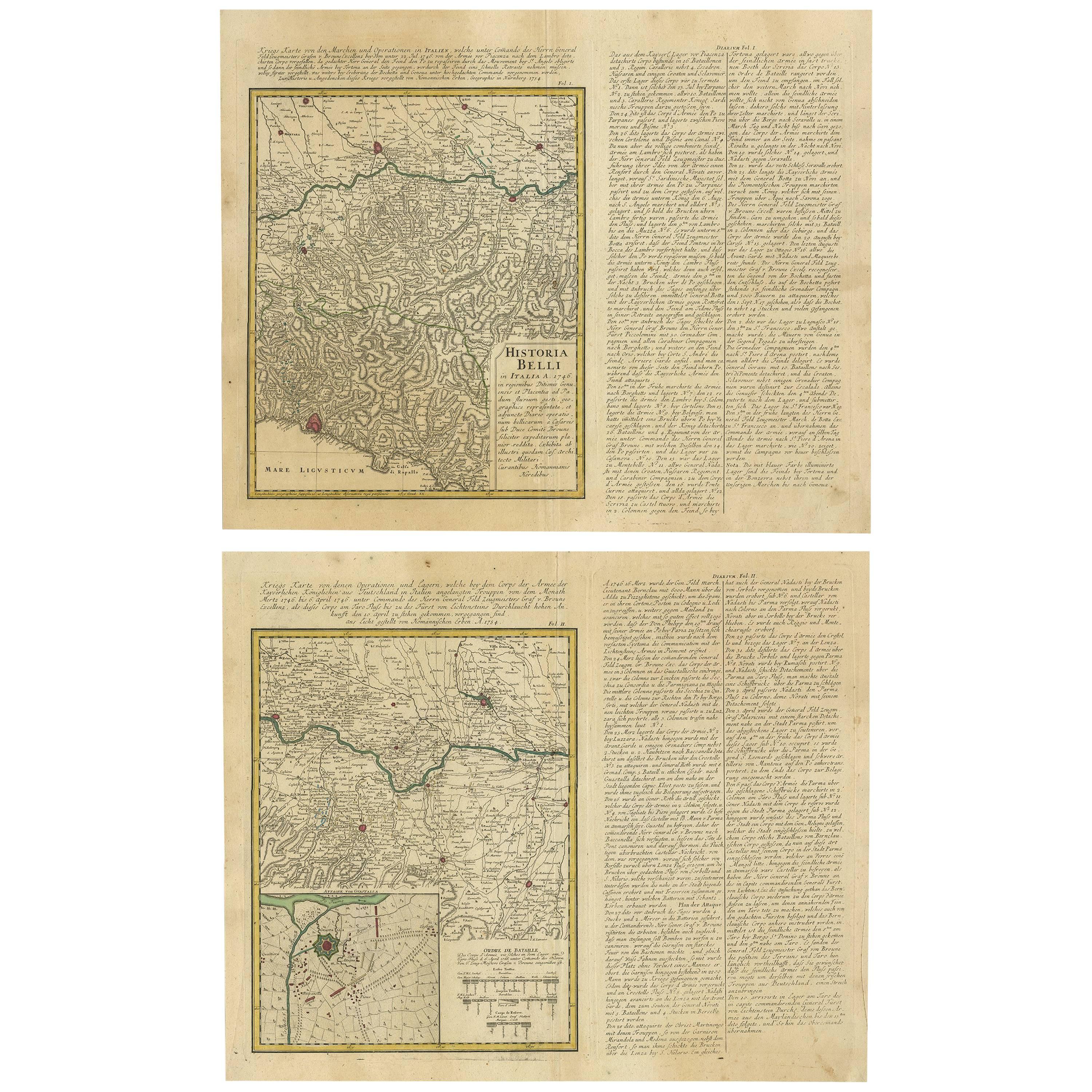
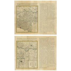
- Set of Two Antique Maps of Northern Italy by Homann Heirs, 1754Located in Langweer, NLSet of two maps of northern Italy showing the position of troups during the war in April and March 1746. The area covered includes the course of the River Po between Valenza (north of Alexandria) and San Benedetto...Category
Antique Mid-18th Century Maps
MaterialsPaper
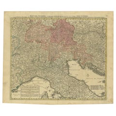
- Antique Map of the Danube River and Surroundings by Homann Heirs, c.1730By Homann HeirsLocated in Langweer, NLAntique map titled 'Danubii Fluminus (a fontibus prope Doneschingam usq Posonium urbem defignati) Pars Superior, in qua Suevia, Bavaria, Asutria, Stiria, Carinthia, Carniola, Tyrolis...Category
Antique 18th Century Maps
MaterialsPaper
- Antique Map of France by Homann Heirs, c.1745Located in Langweer, NLAntique map titled 'Gallia Postarum geographice designata in qua Cursus Postarum Secundum Statum (..)'. Unusual postal map of France, with coat of arms. Very detailed map showing all...Category
Antique 18th Century Maps
MaterialsPaper
- Antique Map of Switzerland by Homann Heirs, c.1732Located in Langweer, NLAntique map titled 'Potentissimae Helvetiorum Reipublicae (..)'. Beautiful detailed map of Switzerland, showing the 13 cantons. The large title cartouche showing 13 coat of arms of t...Category
Antique 18th Century Maps
MaterialsPaper
- Antique Map of Africa by Homann Heirs, '1804'Located in Langweer, NLAntique map titled 'Charte von Africa'. Large, original antique map of Africa by Franz Ludwig Güssefeld. Published by Homann Heirs, 1804.Category
Antique Early 19th Century Maps
MaterialsPaper


You May Also Like
- Hand-Colored 18th Century Homann Map of the Danube, Italy, Greece, CroatiaBy Johann Baptist HomannLocated in Alamo, CA"Fluviorum in Europa principis Danubii" is a hand colored map of the region about the Danube river created by Johann Baptist Homann (1663-1724) in his 'Atlas Novus Terrarum', publish...Category
Antique Early 18th Century German Maps
MaterialsPaper
- Sweden & Adjacent Portions of Scandinavia: A Hand-Colored 18th C. Map by HomannBy Johann Baptist HomannLocated in Alamo, CAThis hand-colored map of Sweden and adjacent portions of Scandinavia entitled "Regni Sueciae in Omnes suas Subjacentes Provincias accurate divisi Tabula Generalis" was created by Joh...Category
Antique 1720s German Maps
MaterialsPaper
- The Kingdom of Naples and Southern Italy: A Hand-Colored 18th Century Homann MapBy Johann Baptist HomannLocated in Alamo, CA"Novissima & exactissimus Totius Regni Neapolis Tabula Presentis Belli Satui Accommo Data" is a hand colored map of southern Italy and the ancient Kingdom of Naples created by Johann...Category
Antique Early 18th Century German Maps
MaterialsPaper
- Antique Map of Italy by Andriveau-Goujon, 1843By Andriveau-GoujonLocated in New York, NYAntique Map of Italy by Andriveau-Goujon, 1843. Map of Italy in two parts by Andriveau-Goujon for the Library of Prince Carini at Palazzo Carini i...Category
Antique 1840s French Maps
MaterialsLinen, Paper
- Scandinavia & Portions of Eastern Europe: 18th Century Hand-Colored Homann MapBy Johann Baptist HomannLocated in Alamo, CAAn early 18th century hand-colored copper-plate map entitled "Regni Sueciae in omnes suas Subjacentes Provincias accurate divisi Tabula Generalis" by Johann Baptist Homann (1663-1724...Category
Antique Early 18th Century German Maps
MaterialsPaper
- Matthaus Seutter, Framed 1730 Color Engraving Map of "Belgium Fonderatum"Located in Bridgeport, CTLabel on verso. From Grosser Atlas. The name Belgium comes from the ancient designation "Gallis Belgica". Figural decoration upper left. M. Seutter was a famed German mapmaker in the...Category
Antique 18th Century European Renaissance Maps
MaterialsBrass


Recently Viewed
View AllMore Ways To Browse
Map Light
Antique Italian Decor
Large Scale Map
Antique Dutch Light
18th C Antique Italian Furniture
Antique Two Tone Light
Antique German Scales
Antique German Scale
Parma Italy
German 18th C
Antique Science
Dutch School Antique
Large City Maps
Lithograph City Maps
City Map Lithograph
Antique School Map
Antique School Maps
18th Century Dutch School