Items Similar to 1601 Miniature Map of Southeast Asia & Nova Guinea by Ortelius, Vrients Edition


Want more images or videos?
Request additional images or videos from the seller
1 of 7
1601 Miniature Map of Southeast Asia & Nova Guinea by Ortelius, Vrients Edition
$645.82
£476.44
€540
CA$894.04
A$969.40
CHF 514.45
MX$11,939.41
NOK 6,376.28
SEK 6,017.74
DKK 4,111.31
About the Item
This miniature map of the East Indies and Nova Guinea was created by Abraham Ortelius and published in 1601 as part of the "Epitome" by Giovanni Battista Vrients. It is a finely hand-colored original example, featuring French text on the verso. This piece is particularly notable for its inclusion in the Vrients editions of Ortelius' atlases, which are highly prized by collectors.
The map beautifully illustrates Southeast Asia, including the Indian subcontinent, China, the Philippines, the Moluccas, Borneo, and New Guinea, as well as parts of Japan and the Pacific Ocean labeled as "Mar del Zur." Cities, rivers, and significant regions such as Indostan, Pegú, Malaca, and Quinsay are prominently marked, with decorative artistic elements enhancing its appeal.
Giovanni Battista Vrients, who acquired the rights to Ortelius’ "Theatrum Orbis Terrarum" and "Epitome" at the turn of the 17th century, expanded the atlases with additional maps and updated editions. These editions are widely regarded as the most collectible due to their detailed engravings, historical significance, and refined artistry.
### Keywords for the Map:
Abraham Ortelius, Giovanni Battista Vrients, 1601, Epitome, miniature map, Southeast Asia, East Indies, Nova Guinea, French edition, historical map, antique map, hand-colored map, Ortelius atlas, collectible maps, early cartography, Age of Exploration, decorative maps, rare maps, Pacific Ocean, Latin text, French text, Vrients edition.
### Regions and Cities Mentioned:
- Regions:
- East Indies
- Indostan (India)
- China
- Pegú (Burma/Myanmar)
- Malaca (Malacca)
- Moluccas (Spice Islands)
- Borneo
- Nova Guinea (New Guinea)
- Mar del Zur (Pacific Ocean)
- Cities:
- Quinsay (Hangzhou, China)
- Cattigara (a legendary location often depicted in early maps)
- Lampon (possibly Lamphun in Thailand)
- Goa
- Macao (Macau)
- Samatra (Sumatra)
This map's focus on key regions and cities of the 16th and 17th centuries, many of which were central to trade and exploration, enhances its value and appeal to collectors.
Condition: This map is in very good condition, with vibrant coloring and crisp engraving lines. The size and intricate details make it a fascinating and desirable piece for those interested in Ortelius’ work or the cartography of Southeast Asia and the Pacific during the Age of Exploration.
This rare and historically significant map would be a fantastic addition to any collection of antique maps, especially those focused on early European depictions of Asia and the Pacific.
- Dimensions:Height: 4.73 in (12 cm)Width: 6.11 in (15.5 cm)Depth: 0.01 in (0.2 mm)
- Materials and Techniques:Paper,Engraved
- Period:1600-1609
- Date of Manufacture:circa 1601
- Condition:This map is in very good condition, with vibrant coloring and crisp engraving lines. The size and intricate details make it a fascinating and desirable piece for those interested in Ortelius’ work or the cartography of Southeast Asia and the Pacific.
- Seller Location:Langweer, NL
- Reference Number:Seller: BG-139221stDibs: LU3054342681842
About the Seller
5.0
Recognized Seller
These prestigious sellers are industry leaders and represent the highest echelon for item quality and design.
Platinum Seller
Premium sellers with a 4.7+ rating and 24-hour response times
Established in 2009
1stDibs seller since 2017
2,620 sales on 1stDibs
Typical response time: <1 hour
- ShippingRetrieving quote...Shipping from: Langweer, Netherlands
- Return Policy
Authenticity Guarantee
In the unlikely event there’s an issue with an item’s authenticity, contact us within 1 year for a full refund. DetailsMoney-Back Guarantee
If your item is not as described, is damaged in transit, or does not arrive, contact us within 7 days for a full refund. Details24-Hour Cancellation
You have a 24-hour grace period in which to reconsider your purchase, with no questions asked.Vetted Professional Sellers
Our world-class sellers must adhere to strict standards for service and quality, maintaining the integrity of our listings.Price-Match Guarantee
If you find that a seller listed the same item for a lower price elsewhere, we’ll match it.Trusted Global Delivery
Our best-in-class carrier network provides specialized shipping options worldwide, including custom delivery.More From This Seller
View AllAntique Map of Southeast Asia by Ortelius '1587'
By Abraham Ortelius
Located in Langweer, NL
Antique map titled 'Indiae Orientalis Insularumque Adiacientium Typus'. Ortelius includes early European depictions of both Japan and China and is the first to name Formosa (Taiwan). The Philippines and East Indies or Spice Islands are shown based upon Portuguese and Spanish sources, and before their penetration by the Dutch. Japan is shown in kite form, as a large oval island...
Category
Antique 16th Century Maps
Materials
Paper

Rare and Very Old Antique Map of South East Asia, Published circa 1574
Located in Langweer, NL
A very fine impression of this map of the Malay Peninsula, Sumatra, Java, with Singapore denoted as 'Cinca Pula'.
Highly distorted and inaccurate map by Girolamo Ruscelli after J...
Category
Antique 16th Century Maps
Materials
Paper

$1,148 Sale Price
20% Off
Free Shipping
Antique Map of India and Southeast Asia by Sanson '1654'
Located in Langweer, NL
Antique map titled 'Partie Meridionale de l'Inde'. Early map of India and Southeast Asia. The map shows most of modern India, Bangladesh and Burma, the whole of Sri Lanka, Thailand, ...
Category
Antique Mid-17th Century Maps
Materials
Paper

$1,145 Sale Price
20% Off
Old Antique Map of the East Indies and Southeast Asia, ca.1644
Located in Langweer, NL
Antique map titled 'India quae Orientalis dicitur, et Insulae adiacentes'.
Old map of the East Indies and Southeast Asia showing the area between India in the West and parts of Japan, the Marianas and New Guinea/Australia in the East. This map is dedicated to D. Christophorus Thisius by Henricus...
Category
Antique 1640s Dutch Maps
Materials
Paper

$2,371 Sale Price
25% Off
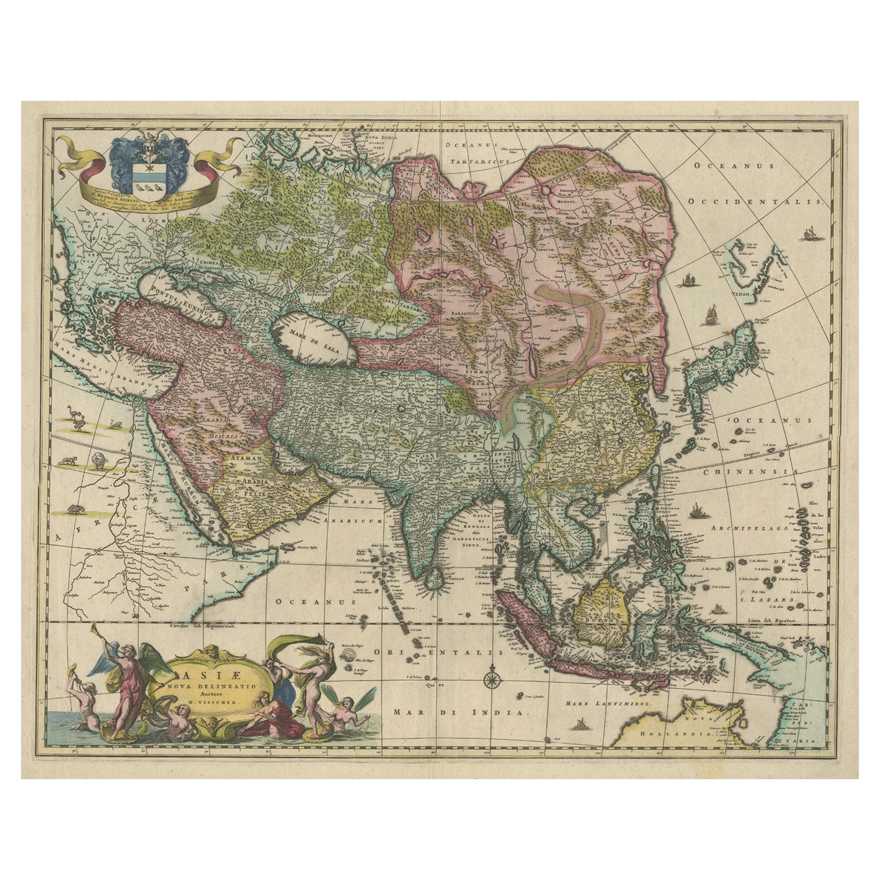
Antique Map of Asia and the East Indies and Korea as a Peninsula, ca.1660
Located in Langweer, NL
Antique map titled 'Asiae nova delineatio'. Decorative map of Asia and the East Indies. The map shows Korea as a peninsula. In China the Great Wall is depicted, as well as a long str...
Category
Antique 17th Century Maps
Materials
Paper
$2,391 Sale Price
20% Off
Free Shipping
Antique Map of Southeast Asia by J. Ottens, 1710
Located in Langweer, NL
Antique map titled 'Le Royaume de Siam avec Les Royaumes Qui Luy sont Tributaries'. Influential map of Southeast Asia. Ottens incorporated information provided by the French Jesuits ...
Category
Antique Early 18th Century Maps
Materials
Paper

$1,008 Sale Price
41% Off
You May Also Like
Map of the East Indies: An Original 18th Century Hand-colored Map by E. Bowen
Located in Alamo, CA
This is an original 18th century hand-colored map entitled "An Accurate Map of the East Indies Exhibiting the Course of the European Trade both on the Continent and Islands" by Emanu...
Category
Mid-18th Century Old Masters Landscape Prints
Materials
Engraving

Antique 1803 Italian Map of Asia Including China Indoneseia India
Located in Amsterdam, Noord Holland
Antique 1803 Italian Map of Asia Including China Indoneseia India
Very nice map of Asia. 1803.
Additional information:
Type: Map
Country of Manufacturing: Europe
Period: 19th centu...
Category
Antique 19th Century European Maps
Materials
Paper

$584 Sale Price
20% Off
West Africa: A 17th Century Hand-Colored Map by Mercator/Hondius
By Gerard Mercator
Located in Alamo, CA
A 17th century hand-colored map entitled "Guineae Nova Descriptio" by Gerard Mercator and Jodocus Hondius, published in their 'Atlas Minor' in Amsterdam in 1635. It is focused on the...
Category
1630s Landscape Prints
Materials
Engraving

Asia Declineatio: A 17th Century Hand-colored Map of Asia by Justus Danckerts
Located in Alamo, CA
This is a scarce 17th century beautifully hand-colored copperplate engraved map of Asia entitled “Exactissima Asiae Delineatio in Praecipuas Regiones Caerterasque Partes divisa et de...
Category
Late 17th Century Old Masters Landscape Prints
Materials
Engraving

1592 Abraham Ortelius Map "Lorraine: Lotharingiae Nova Descripti, Ric.A005
Located in Norton, MA
1592 Abraham Ortelius map entitled
"Lorraine: Lotharingiae Nova Descripti
Ric.a005
Description: Ortelius is best known for producing the atlas from which this map comes from, "...
Category
Antique 16th Century Dutch Maps
Materials
Paper

Antique French Map of Asia Including China Indoneseia India, 1783
Located in Amsterdam, Noord Holland
Very nice map of Asia. 1783 Dedie au Roy.
Additional information:
Country of Manufacturing: Europe
Period: 18th century Qing (1661 - 1912)
Condition: Overall Condition B (Good Used)...
Category
Antique 18th Century European Maps
Materials
Paper

$648 Sale Price
20% Off
More Ways To Browse
Japanese Labels
Blue Green Wool And Silk Rug
Brown Sheepskin Chair
Vintage Brass Bar Carts
Antique Botanical Prints
Green Persian Rug
50 X 50 Coffee Table
Milo Baughman 1970
Spanish Baroque Furniture
Stone China
Couch Console
Vintage Burn
Chinese Stone
Sterling Silver Flatware Service For 12
Antique Dining Tables With Leaves
Decorative Wall Panels
Frank Lloyd Wright For Cassina
Natural Curved