Items Similar to 1726 Valentyn's Map of Bali and Lombok, Original Engraving


Want more images or videos?
Request additional images or videos from the seller
1 of 6
1726 Valentyn's Map of Bali and Lombok, Original Engraving
$1,435.16
$1,793.9520% Off
£1,058.75
£1,323.4420% Off
€1,200
€1,50020% Off
CA$1,986.76
CA$2,483.4420% Off
A$2,154.23
A$2,692.7820% Off
CHF 1,143.22
CHF 1,429.0320% Off
MX$26,532.02
MX$33,165.0320% Off
NOK 14,169.51
NOK 17,711.8920% Off
SEK 13,372.76
SEK 16,715.9520% Off
DKK 9,136.24
DKK 11,420.3020% Off
About the Item
This antique map is a detailed 18th-century chart of the island of Bali, one of the many islands of Indonesia, with an inset of the neighboring island Lombok, attributed to François Valentyn or Valentijn. He was a Dutch minister and author who worked for the Dutch East India Company, and his maps are well-regarded for their detail and accuracy.
The map includes intricate details of Bali's coastline, mountainous regions. It also features depth soundings around the coast, suggesting it was used for navigation. The presence of the compass rose indicates the orientations. The map is in good condition with visible fold lines, common in maps designed to be used or stored in atlases. The hand coloring has done recently.
François Valentyn was a prominent Dutch minister and historian known for his detailed works about the East Indies, compiled through his time with the Dutch East India Company. His notable work includes the comprehensive "Oud en Nieuw Oost-Indiën" which included descriptions and maps of the Dutch colonial territories. J. van Braam and Gerard onder de Linden were publishers based in the Dutch city of Dordrecht and Amsterdam, respectively. They were involved in printing and distributing Valentyn's works, contributing to the dissemination of geographical knowledge during the Dutch Golden Age of exploration and cartography. Their collaboration resulted in works that combined accurate cartographic detail with the rich descriptions of the regions, valuable for both navigation and general knowledge.
- Dimensions:Height: 21.66 in (55 cm)Width: 24.41 in (62 cm)Depth: 0 in (0.02 mm)
- Materials and Techniques:Paper,Engraved
- Period:
- Date of Manufacture:1726
- Condition:The map is in good condition with visible fold lines, common in maps designed to be used or stored in atlases. The hand coloring is vibrant, but of later date. A bit rough around the edges due to age and handling. Study the image carefully.
- Seller Location:Langweer, NL
- Reference Number:Seller: BG-13424-441stDibs: LU3054337742582
About the Seller
5.0
Recognized Seller
These prestigious sellers are industry leaders and represent the highest echelon for item quality and design.
Platinum Seller
Premium sellers with a 4.7+ rating and 24-hour response times
Established in 2009
1stDibs seller since 2017
2,622 sales on 1stDibs
Typical response time: <1 hour
- ShippingRetrieving quote...Shipping from: Langweer, Netherlands
- Return Policy
Authenticity Guarantee
In the unlikely event there’s an issue with an item’s authenticity, contact us within 1 year for a full refund. DetailsMoney-Back Guarantee
If your item is not as described, is damaged in transit, or does not arrive, contact us within 7 days for a full refund. Details24-Hour Cancellation
You have a 24-hour grace period in which to reconsider your purchase, with no questions asked.Vetted Professional Sellers
Our world-class sellers must adhere to strict standards for service and quality, maintaining the integrity of our listings.Price-Match Guarantee
If you find that a seller listed the same item for a lower price elsewhere, we’ll match it.Trusted Global Delivery
Our best-in-class carrier network provides specialized shipping options worldwide, including custom delivery.More From This Seller
View AllAntique Map of Java and Madura Island, Indonesia, c.1760
Located in Langweer, NL
Antique map titled 'Idee de l'Isle de Java.'
Well engraved and attractive chart of the island shows all principal harbors and coastal details, plus rivers, mountains and volcanoe...
Category
Antique 18th Century Maps
Materials
Paper

$430 Sale Price
20% Off
Antique Map of Ambon Island in the Moluccas, Indonesia, c.1760
Located in Langweer, NL
Antique map Ambon titled 'Carte Particuliere de l 'Isle Amboine'. Old map showing Ambon, in the Moluccas Islands, better known as the Spice Islands. Ambon was the headquarters of the...
Category
Antique 18th Century Maps
Materials
Paper

$229 Sale Price
20% Off
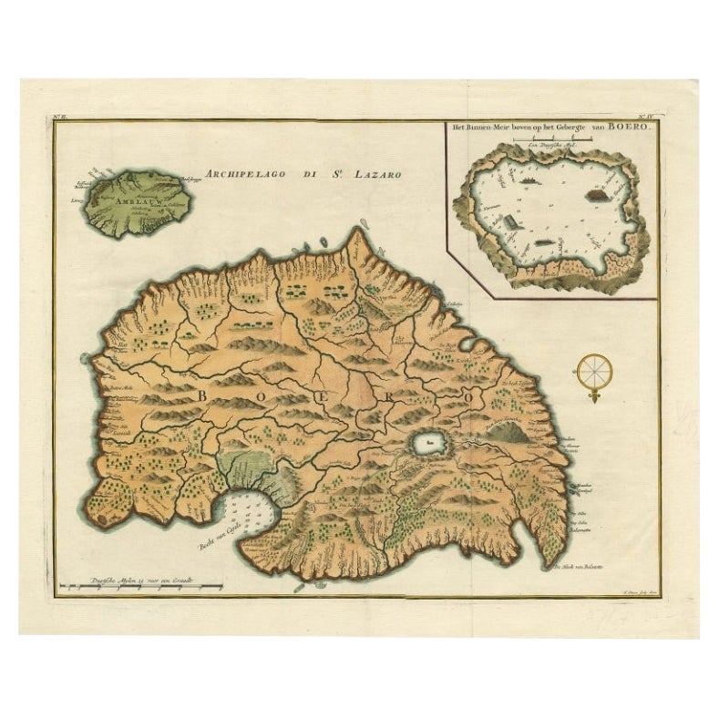
Antique Map of Ambelau and Buru Island, Maluku or Moluccas in Indonesia, 1726
Located in Langweer, NL
Antique map titled 'Boero - Amblauw (..).' Detailed map of the Island Ambelau and Buru, Maluku Islands, Indonesia, by Francois Valentyn. With an inset of the lake on the Buru mountai...
Category
Antique 18th Century Maps
Materials
Paper

$354 Sale Price
20% Off
Antique Map of the Island of Borneo in Asia (Indonesia), 1726
Located in Langweer, NL
Antique map titled 'Kaart van het Eyland Borneo'. Early map of the island of Borneo. This map originates from 'Oud en Nieuw Oost-Indiën' by F. Valentijn.
Artists and Engravers: Fran...
Category
Antique 18th Century Maps
Materials
Paper

$3,690 Sale Price
20% Off
Antique Map of the Island of Java, Indonesia by P. Van Der Aa, 1713
Located in Langweer, NL
This rare map shows the Indonesian island of Java. With compass rose and scale. From: Nouvel Atlas, très exact et fort commode pour toutes sortes de personnes, Contenant Les Principa...
Category
Antique Early 18th Century Maps
Materials
Paper

$650 Sale Price
20% Off
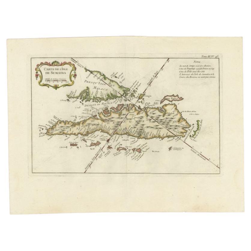
Antique Map of Sumatra by Bellin, 1764
Located in Langweer, NL
Antique map Sumatra titled 'Carte de l'Isle de Sumatra'. Old map of Sumatra, Malaysia and the Straits of Malacca, including Singapore. This map originates ...
Category
Antique 18th Century Maps
Materials
Paper

$464 Sale Price
20% Off
You May Also Like
Antique French Map of Asia Including China Indoneseia India, 1783
Located in Amsterdam, Noord Holland
Very nice map of Asia. 1783 Dedie au Roy.
Additional information:
Country of Manufacturing: Europe
Period: 18th century Qing (1661 - 1912)
Condition: Overall Condition B (Good Used)...
Category
Antique 18th Century European Maps
Materials
Paper

$648 Sale Price
20% Off
Antique 1803 Italian Map of Asia Including China Indoneseia India
Located in Amsterdam, Noord Holland
Antique 1803 Italian Map of Asia Including China Indoneseia India
Very nice map of Asia. 1803.
Additional information:
Type: Map
Country of Manufacturing: Europe
Period: 19th centu...
Category
Antique 19th Century European Maps
Materials
Paper

$584 Sale Price
20% Off
Original Antique Map of Switzerland, Engraved By Barlow, Dated 1807
Located in St Annes, Lancashire
Great map of Switzerland
Copper-plate engraving by Barlow
Published by Brightly & Kinnersly, Bungay, Suffolk.
Dated 1807
Unframed.
Category
Antique Early 1800s English Maps
Materials
Paper

Map of the East Indies: An Original 18th Century Hand-colored Map by E. Bowen
Located in Alamo, CA
This is an original 18th century hand-colored map entitled "An Accurate Map of the East Indies Exhibiting the Course of the European Trade both on the Continent and Islands" by Emanu...
Category
Mid-18th Century Old Masters Landscape Prints
Materials
Engraving

Antique Voc Print Holland Malaysia Old Map Melaka History, 1663
Located in Amsterdam, Noord Holland
From my own collection I offer this impressive Antique print of the city of Malakka
A very interesting piece for collectors . It is an museum piece from the Dutch Institute of Orien...
Category
Antique 17th Century European Paintings
Materials
Paper

$293 Sale Price
20% Off
Original Antique Map of South East Asia by Thomas Clerk, 1817
Located in St Annes, Lancashire
Great map of South East Asia
Copper-plate engraving
Drawn and engraved by Thomas Clerk, Edinburgh.
Published by Mackenzie And Dent, 1817
Unframed.
Category
Antique 1810s English Maps
Materials
Paper

More Ways To Browse
East India Company
Dutch East India Company
Bali Furniture
Bali Antique
Holland And Company
Van Braam
Stretcher Tables
M Table
Antique Sultanabad Carpets
China Chair
English Antique Desks
Used Beige Sofa
Antique Plate Germany
Hand Tufted Rugs
Rare China
Side Table Made In Denmark
Thonet Antique
Victorian Hall Tables