Items Similar to 1748 Homann Heirs Double Map of the East Indies and Southeast Asia


Want more images or videos?
Request additional images or videos from the seller
1 of 6
1748 Homann Heirs Double Map of the East Indies and Southeast Asia
$1,129.20
£840.90
€950
CA$1,559.01
A$1,728.39
CHF 908.34
MX$21,152.66
NOK 11,344.20
SEK 10,647.66
DKK 7,232.98
About the Item
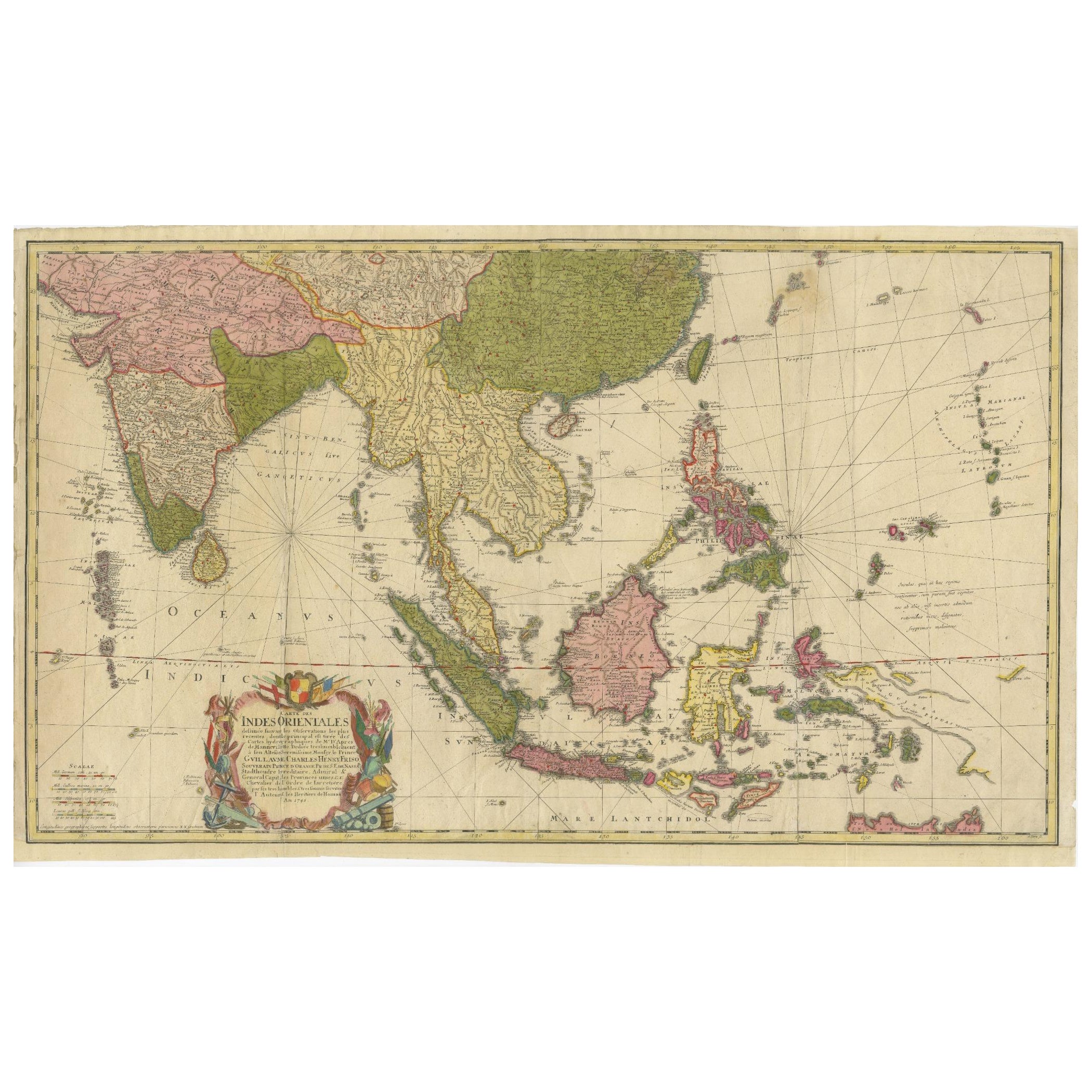
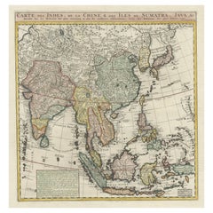
Title: 1774 Homann Heirs Double Map of the East Indies and Southeast Asia
Description:
This stunning 1774 double map by the Homann Heirs showcases the East Indies and Southeast Asia, offering a richly detailed view of one of the world’s most significant trade regions during the 18th century. The maps depict the area spanning from India to the Philippines and include prominent features such as the Indonesian archipelago, the Malaysian Peninsula, and parts of China and Japan. The intricate cartography highlights the region’s topography, including islands, coastlines, rivers, and important ports, making it an invaluable tool for historical and geographical study.
The left map features a grand cartouche adorned with allegorical imagery, emphasizing the region's importance in trade and exploration. It covers India and parts of Southeast Asia, with political boundaries carefully marked. The right map focuses on maritime navigation, detailing the Philippines, Borneo, Java, and the surrounding islands. Together, the maps offer a complete picture of the economic and political landscape during the height of European colonial expansion.
These maps were designed by Tobias Mayer and reflect the Homann Heirs’ commitment to accuracy and artistry. The engraved details, combined with original hand-coloring, create a visually striking piece that is both decorative and informative. Collectors and enthusiasts of cartography, maritime history, or colonial studies will find this pair an exceptional addition to any collection.
Condition Report: The maps are in fair to good condition with crisp engraving and vibrant original hand-coloring. Age-related toning and faint foxing are visible but do not detract from their overall appeal. No tears or repairs noted, but paper showing creases and wear due to handling over the last 300 years.
Framing and Matting Tips:
For a cohesive display, stitch the two maps as one composition or frame them side by side. Use a neutral archival mat to emphasize the intricate details, and a dark wooden or antique-style frame to complement their historical aesthetic. UV-protective glass is recommended to prevent fading. Adding a descriptive plaque with the maps' historical context would enhance their appeal as a centerpiece in any room.
- Dimensions:Height: 20.87 in (53 cm)Width: 18.71 in (47.5 cm)Depth: 0.01 in (0.2 mm)
- Materials and Techniques:Paper,Engraved
- Period:1740-1749
- Date of Manufacture:1748
- Condition:Fair condition with crisp engraving and vibrant original hand-coloring. Age-related toning and faint foxing are visible but do not detract from their overall appeal. No tears or repairs noted, but paper showing creases and wear due to handling.
- Seller Location:Langweer, NL
- Reference Number:Seller: BG-14044-3 & BG-14044-41stDibs: LU3054343437762
About the Seller
5.0
Recognized Seller
These prestigious sellers are industry leaders and represent the highest echelon for item quality and design.
Platinum Seller
Premium sellers with a 4.7+ rating and 24-hour response times
Established in 2009
1stDibs seller since 2017
2,609 sales on 1stDibs
Typical response time: <1 hour
- ShippingRetrieving quote...Shipping from: Langweer, Netherlands
- Return Policy
Authenticity Guarantee
In the unlikely event there’s an issue with an item’s authenticity, contact us within 1 year for a full refund. DetailsMoney-Back Guarantee
If your item is not as described, is damaged in transit, or does not arrive, contact us within 7 days for a full refund. Details24-Hour Cancellation
You have a 24-hour grace period in which to reconsider your purchase, with no questions asked.Vetted Professional Sellers
Our world-class sellers must adhere to strict standards for service and quality, maintaining the integrity of our listings.Price-Match Guarantee
If you find that a seller listed the same item for a lower price elsewhere, we’ll match it.Trusted Global Delivery
Our best-in-class carrier network provides specialized shipping options worldwide, including custom delivery.More From This Seller
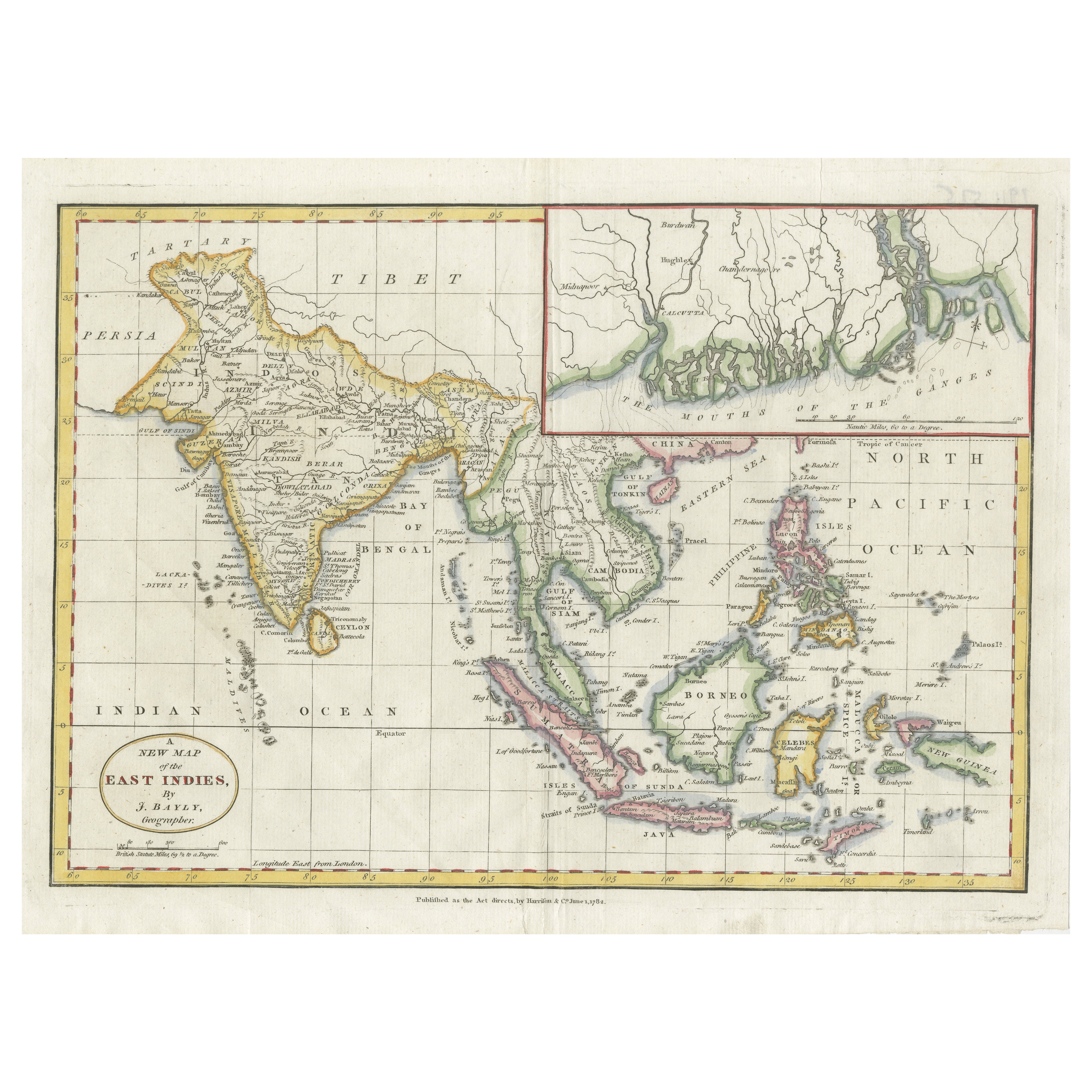
View All1782 Map of the East Indies – India, Siam, Philippines, Java, Borneo, Ganges
Located in Langweer, NL
1782 Bayly Map of the East Indies – India, Siam, Philippines, Java, Borneo, Ganges
This finely engraved and vibrantly hand-colored map titled 'A New Map of the East Indies' was dr...
Category
Antique 1780s Maps
Materials
Paper
$313 Sale Price
20% Off
Rare 18th-Century Hand-Colored Map of Southeast Asia and the East Indies, 1748
Located in Langweer, NL
1748 Homann Map of Southeast Asia and East Indies by Homann Heirs
This original 1748 map, published by the renowned Homann Heirs, depicts Southeast Asia, the East Indies, and adjace...
Category
Antique 1740s Maps
Materials
Paper

Large Antique Map of Asia including All of Southeast Asia, c.1792
Located in Langweer, NL
Antique map titled 'L' Asie Divisee en ses Empires, Royaumes, et Etats'. Attractive, large map of Asia including all of Southeast Asia. The cartography is archaic for the period with...
Category
Antique 18th Century Maps
Materials
Paper

$1,426 Sale Price
20% Off
Free Shipping
Antique Map of the East Indies by Bonne '1776'
Located in Langweer, NL
Antique map titled 'Indes IVe Feuille'. Very decorative original antique map of the East Indies. Covbers from the Gulf of Siam (Gulf of Thailand) and Malacca (Malaysia) eastward to i...
Category
Antique Late 18th Century Maps
Materials
Paper

$523 Sale Price
20% Off
Old Antique Map of the East Indies and Southeast Asia, ca.1644
Located in Langweer, NL
Antique map titled 'India quae Orientalis dicitur, et Insulae adiacentes'.
Old map of the East Indies and Southeast Asia showing the area between India in the West and parts of Japan, the Marianas and New Guinea/Australia in the East. This map is dedicated to D. Christophorus Thisius by Henricus...
Category
Antique 1640s Dutch Maps
Materials
Paper

$2,362 Sale Price
25% Off
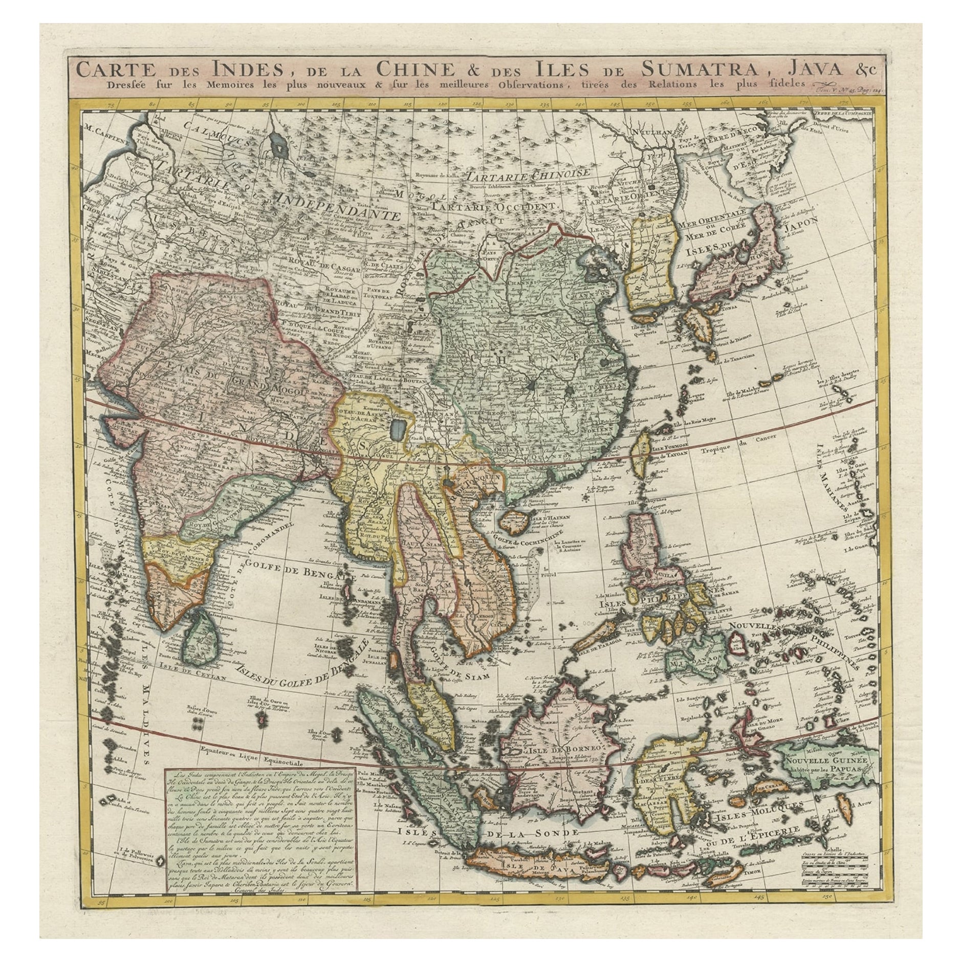
Detailed Original Antique Map of India, Southeast Asia and the Far East, 1719
Located in Langweer, NL
Antique map titled 'Carte des Indes, de la Chine & des Iles de Sumatra, Java & c'.
Detailed map of India, Southeast Asia and the Far East, extending from Gujerat to the supposed "T...
Category
Antique 1710s Maps
Materials
Paper
$1,664 Sale Price
20% Off
You May Also Like
Antique 1803 Italian Map of Asia Including China Indoneseia India
Located in Amsterdam, Noord Holland
Antique 1803 Italian Map of Asia Including China Indoneseia India
Very nice map of Asia. 1803.
Additional information:
Type: Map
Country of Manufacturing: Europe
Period: 19th centu...
Category
Antique 19th Century European Maps
Materials
Paper

$584 Sale Price
20% Off
Antique French Map of Asia Including China Indoneseia India, 1783
Located in Amsterdam, Noord Holland
Very nice map of Asia. 1783 Dedie au Roy.
Additional information:
Country of Manufacturing: Europe
Period: 18th century Qing (1661 - 1912)
Condition: Overall Condition B (Good Used)...
Category
Antique 18th Century European Maps
Materials
Paper

$648 Sale Price
20% Off
Map of the East Indies: An Original 18th Century Hand-colored Map by E. Bowen
Located in Alamo, CA
This is an original 18th century hand-colored map entitled "An Accurate Map of the East Indies Exhibiting the Course of the European Trade both on the Continent and Islands" by Emanu...
Category
Mid-18th Century Old Masters Landscape Prints
Materials
Engraving

Original Antique Map of South East Asia by Thomas Clerk, 1817
Located in St Annes, Lancashire
Great map of South East Asia
Copper-plate engraving
Drawn and engraved by Thomas Clerk, Edinburgh.
Published by Mackenzie And Dent, 1817
Unframed.
Category
Antique 1810s English Maps
Materials
Paper

Large Original Vintage Map of S.E Asia, with a Vignette of Singapore
Located in St Annes, Lancashire
Great map of South East Asia
Original color. Good condition
Published by Alexander Gross
Unframed.
Category
Vintage 1920s English Maps
Materials
Paper

Asia Declineatio: A 17th Century Hand-colored Map of Asia by Justus Danckerts
Located in Alamo, CA
This is a scarce 17th century beautifully hand-colored copperplate engraved map of Asia entitled “Exactissima Asiae Delineatio in Praecipuas Regiones Caerterasque Partes divisa et de...
Category
Late 17th Century Old Masters Landscape Prints
Materials
Engraving

More Ways To Browse
Philippines Antique
Tobias Antique
Japanese Picture Frame
Antique Chinese Picture Frames
Indonesian Mat
Borneo Mat
Antique Chinese Wooden Plaque
Carlo Scarpa 1934 Chairs
Christofle Marly
1900 Antique Chairs
Glass Table Italian Round
Alvar Aalto Poster
Geometric Metal Table
Post Modern High Chairs
Vintage Vine Rug
Cancel An Order
Antique Framing Square
Silver Metal Chair