Items Similar to Antique Dutch Map of Zuid-Holland & Utrecht – Sleeswijk Provincial Atlas, 1914

Want more images or videos?
Request additional images or videos from the seller
1 of 10
Antique Dutch Map of Zuid-Holland & Utrecht – Sleeswijk Provincial Atlas, 1914
$250.52
£185.19
€210
CA$347.49
A$378.84
CHF 200.17
MX$4,658.81
NOK 2,488.96
SEK 2,343.02
DKK 1,599.04
About the Item
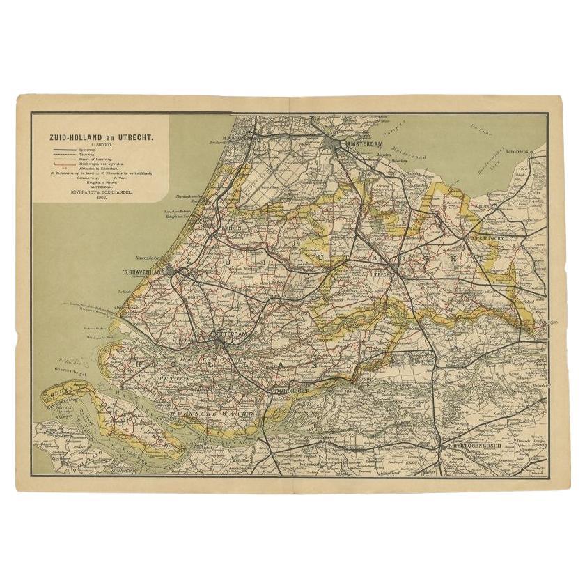
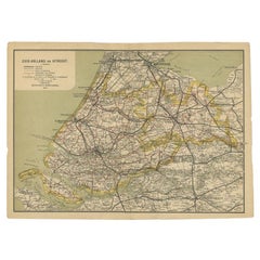
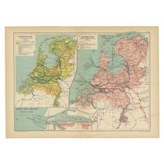
Antique Map of Zuid-Holland & Utrecht – Sleeswijk Atlas, 1914
This antique map of Zuid-Holland and Utrecht was published in 1914 in the well-known Sleeswijk Atlas, a Dutch school atlas widely used for geography education in the early 20th century. It captures two of the most important provinces in the Netherlands, presenting a wealth of detail on the urban, rural, and infrastructural landscape during a pivotal period in Dutch history.
The map extends from the North Sea coast with Scheveningen and Katwijk eastwards across the province of Utrecht, and from Amsterdam in the north to Dordrecht and the river delta in the south. Major cities including The Hague, Rotterdam, Utrecht, Leiden, and Gouda are prominently marked, while an intricate web of smaller towns and villages fills the surrounding landscape. The extensive railway system is shown in red, illustrating the rapid expansion of transportation networks at the beginning of the 20th century. Waterways, rivers, canals, and polders are carefully delineated, reflecting the ongoing Dutch mastery of hydraulic engineering and land reclamation.
The legend (“Verklaring”) at upper left provides symbols for tramways, provincial roads, municipal boundaries, and water defenses, giving the map both practical and educational value. With a scale of 1:400,000, the sheet combines clarity and precision, qualities that made the Sleeswijk Atlas a staple in Dutch schools for decades. Printed in soft colors with clean, legible typography, it is characteristic of the elegant cartography of early 20th-century educational maps.
Published by A. Sleeswijk in Bussum and lithographed by J. Smulders & Co. in The Hague, this map represents the high standards of Dutch school cartography at the time. Today, it serves both as an attractive decorative item and as a document of regional history, offering insight into the provinces during the years just before the First World War.
Condition report: Very good condition with original centerfolds as issued. Minor age toning and light handling traces at the margins. Plate mark visible. Colors remain fresh and well preserved.
Framing tips: A soft ivory or pale cream mat will enhance the pastel tones, while a slim black or dark wood frame will provide a modern, clean contrast. For a more traditional effect, a gilt frame adds warmth and highlights the map’s historic character.
Technique: Lithograph with original color
Maker: A. Sleeswijk, Bussum / J. Smulders & Co., The Hague, 1914
- Dimensions:Height: 9.38 in (23.8 cm)Width: 14.3 in (36.3 cm)Depth: 0.01 in (0.2 mm)
- Materials and Techniques:
- Place of Origin:
- Period:
- Date of Manufacture:circa 1914
- Condition:Condition report: Very good condition with original centerfolds as issued. Minor age toning and light handling traces at the margins. Plate mark visible. Colors remain fresh and well preserved.
- Seller Location:Langweer, NL
- Reference Number:Seller: BG-07094-21stDibs: LU3054346556552
About the Seller
5.0
Recognized Seller
These prestigious sellers are industry leaders and represent the highest echelon for item quality and design.
Platinum Seller
Premium sellers with a 4.7+ rating and 24-hour response times
Established in 2009
1stDibs seller since 2017
2,620 sales on 1stDibs
Typical response time: <1 hour
- ShippingRetrieving quote...Shipping from: Langweer, Netherlands
- Return Policy
Authenticity Guarantee
In the unlikely event there’s an issue with an item’s authenticity, contact us within 1 year for a full refund. DetailsMoney-Back Guarantee
If your item is not as described, is damaged in transit, or does not arrive, contact us within 7 days for a full refund. Details24-Hour Cancellation
You have a 24-hour grace period in which to reconsider your purchase, with no questions asked.Vetted Professional Sellers
Our world-class sellers must adhere to strict standards for service and quality, maintaining the integrity of our listings.Price-Match Guarantee
If you find that a seller listed the same item for a lower price elsewhere, we’ll match it.Trusted Global Delivery
Our best-in-class carrier network provides specialized shipping options worldwide, including custom delivery.More From This Seller
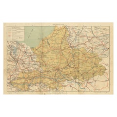
View AllAntique Dutch Map of Gelderland – Sleeswijk Provincial Atlas, 1914
Located in Langweer, NL
Antique Map of Gelderland – Sleeswijk Atlas, 1914
Description:
This antique map of Gelderland was published in 1914 in the Sleeswijk Atlas, one of the most widely used Dutch school ...
Category
Early 20th Century Dutch Maps
Materials
Paper
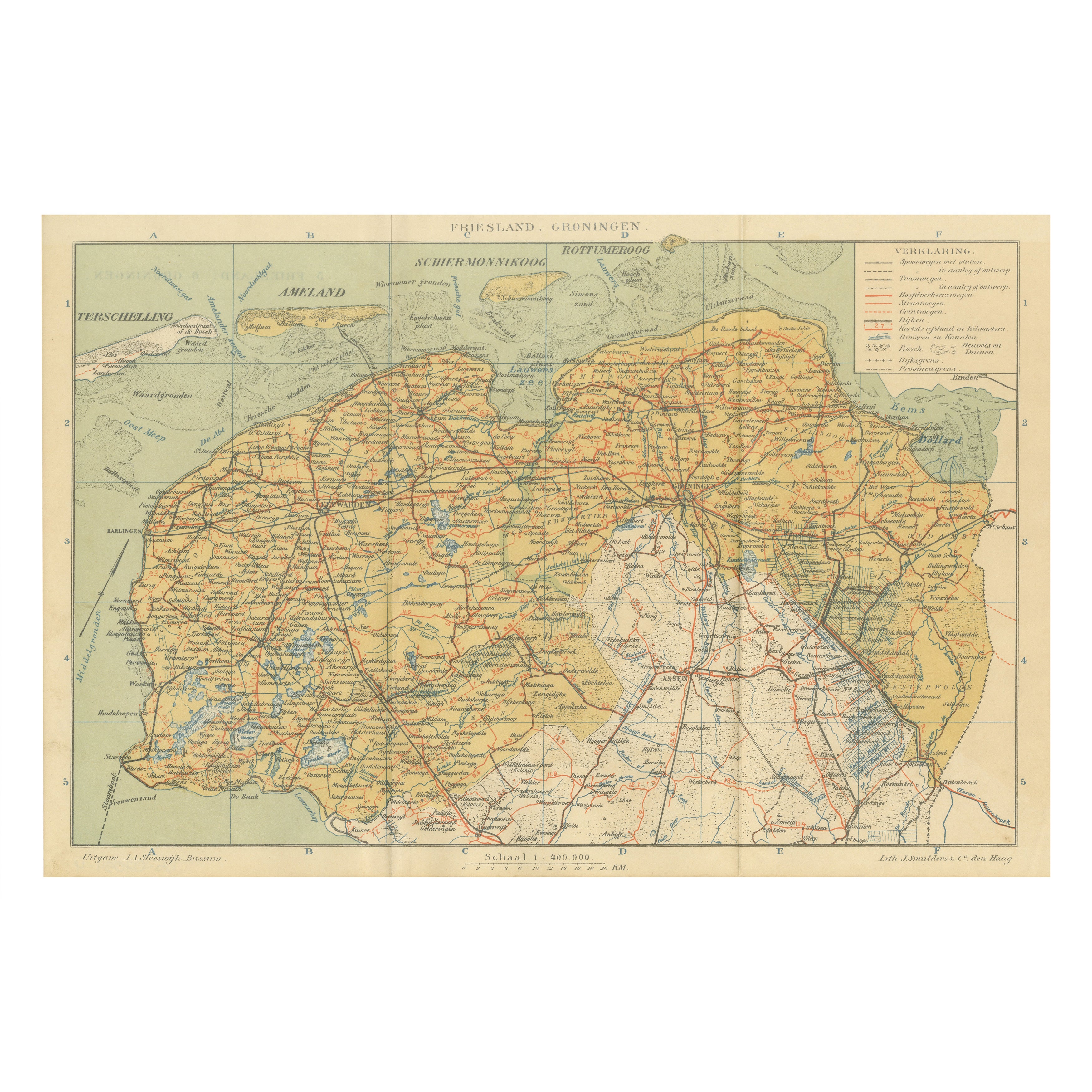
Antique Map of Friesland & Groningen – Sleeswijk Atlas Dutch Provinces, 1914
Located in Langweer, NL
Antique Map of Friesland & Groningen – Sleeswijk Atlas, 1914
Description:
This antique map of Friesland and Groningen was published in 1914 in the Sleeswijk Atlas, a Dutch school at...
Category
Early 20th Century Dutch Maps
Materials
Paper
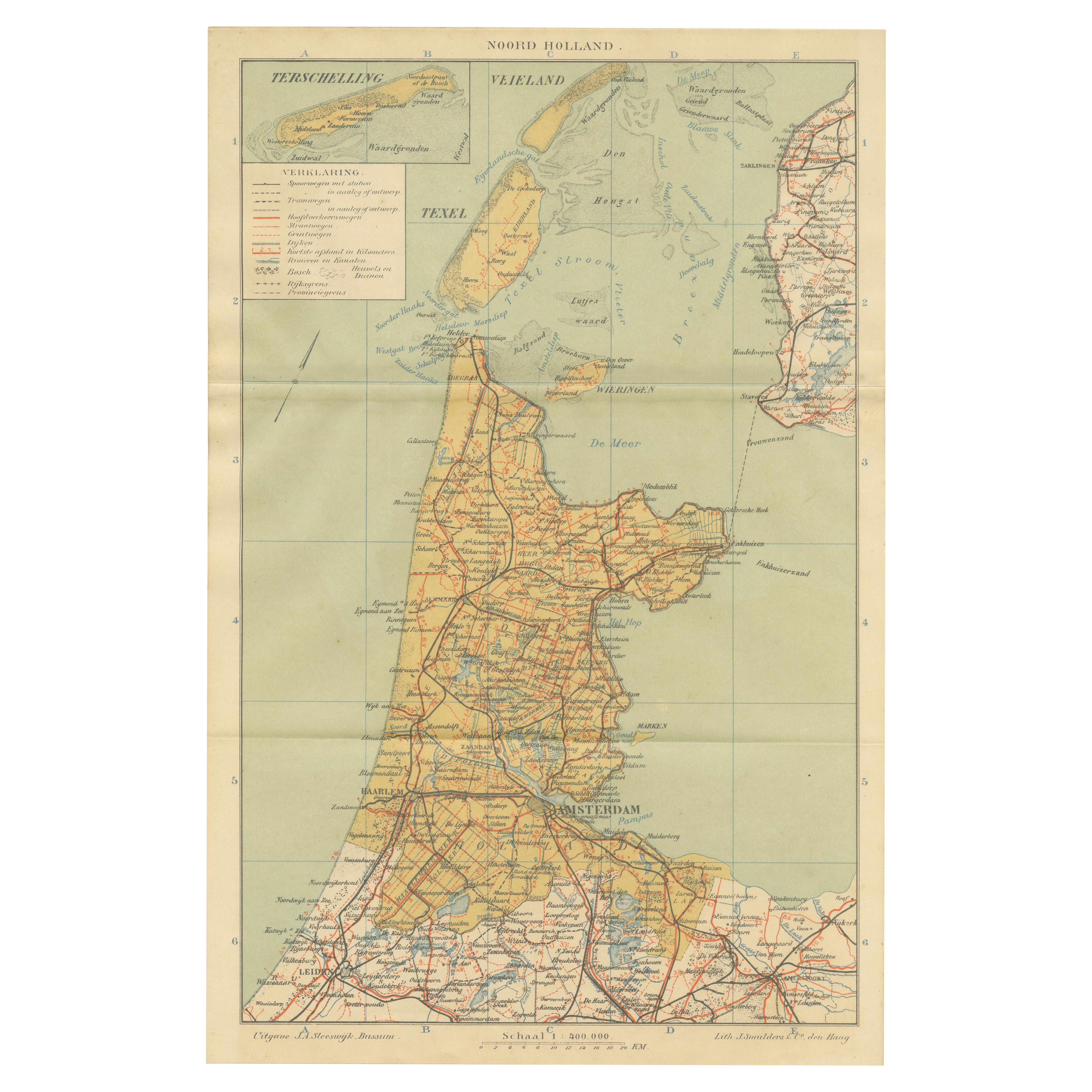
Antique Dutch Map – Province of Noord-Holland from Sleeswijk Atlas, 1914
Located in Langweer, NL
Antique Map of Noord-Holland – Sleeswijk Atlas, 1914
This finely detailed antique map of Noord-Holland was published in 1914 as part of the Sleeswijk Atlas, an important Dutch schoo...
Category
Early 20th Century Dutch Maps
Materials
Paper

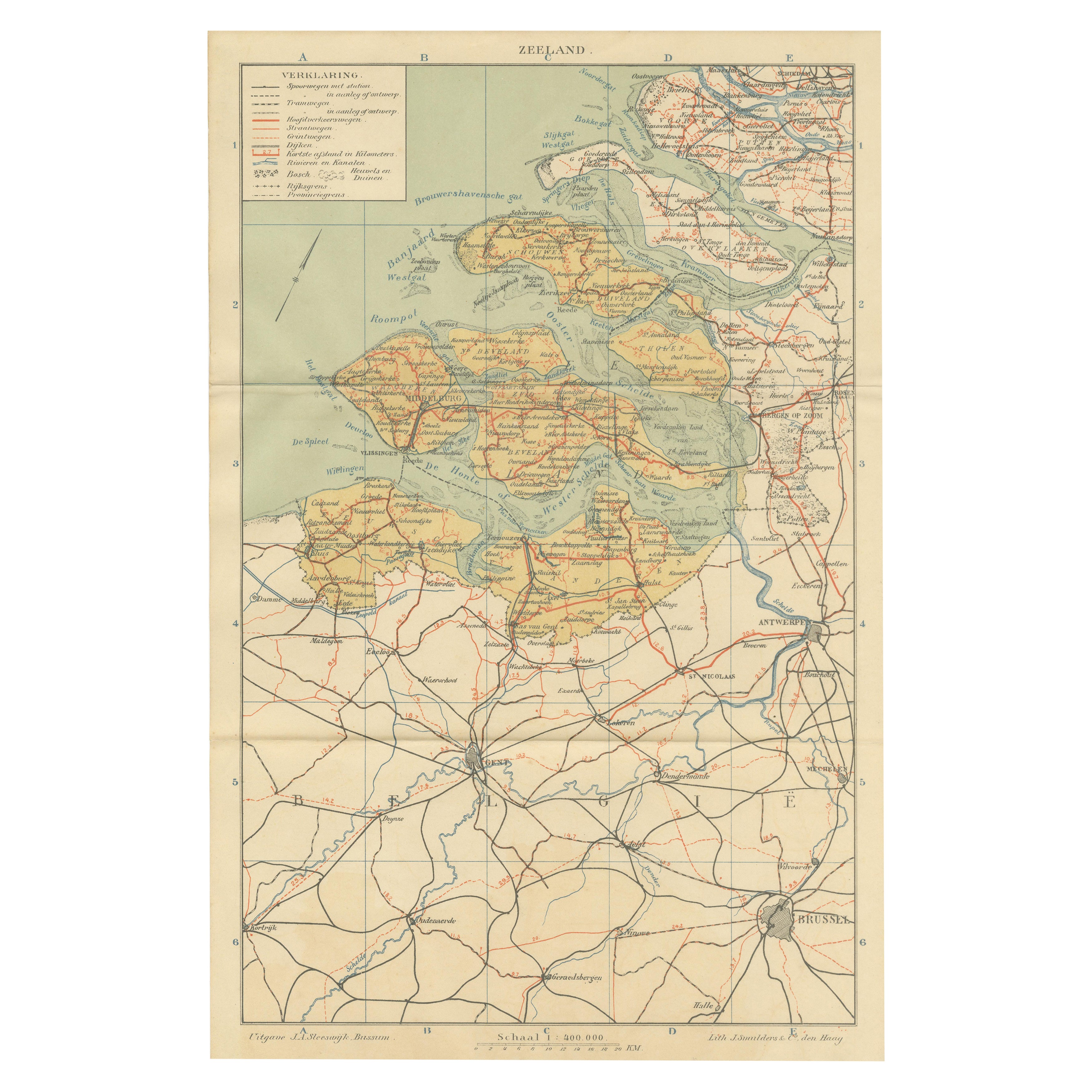
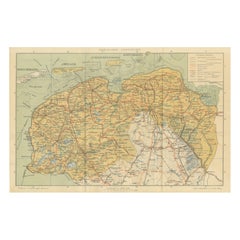
Rare Antique Map of Zeeland – Sleeswijk Atlas of the Netherlands, 1914
Located in Langweer, NL
Antique Map of Zeeland – Sleeswijk Atlas, 1914
This antique map of Zeeland was published in 1914 in the Sleeswijk Atlas, one of the most widely used Dutch school atlases of the earl...
Category
Early 20th Century Dutch Maps
Materials
Paper

Antique Map of Zuid-Holland and Utrecht in The Netherlands, 1902
Located in Langweer, NL
Antique map titled 'Zuid-Holland en Utrecht'. Lithographed map of the provinces of Zuid-Holland and Utrecht, the Netherlands. This map originates from 'Atlas van Nederland'.
Artist...
Category
20th Century Maps
Materials
Paper
$124 Sale Price
20% Off
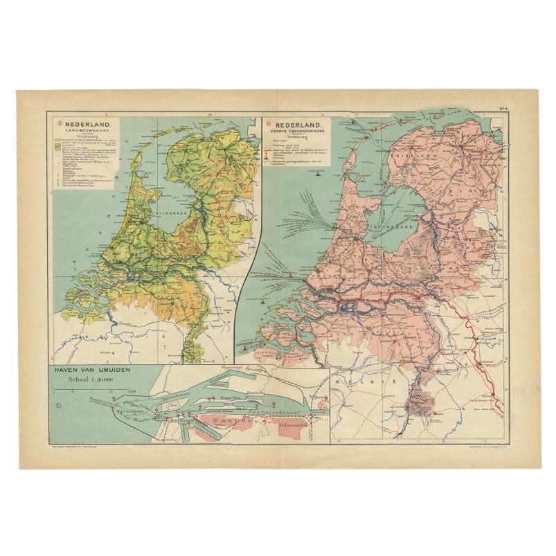
Antique Map of the Netherlands and IJmuiden by Beekman & Schuiling, 1927
Located in Langweer, NL
Two maps on one sheet titled 'Nederland Landbouwkaart' and 'Nederland Groote Verkeerswegen'. With an inset map of the harbour of IJmuiden (The Netherlands). This map originates from ...
Category
20th Century Maps
Materials
Paper
$62 Sale Price
20% Off
You May Also Like
The Netherlands (Holland), Belgium and Luxemburg. Century Atlas antique map
Located in Melbourne, Victoria
'The Century Atlas. The Netherlands (Holland), Belgium and Luxemburg.'
Original antique map, 1903.
Inset maps of 'Amsterdam' and 'Brussels'.
Central fold as issued. Map name and num...
Category
Early 20th Century Victorian More Prints
Materials
Lithograph

Original Antique Map or City Plan of Amsterdam, Netherlands. Circa 1835
Located in St Annes, Lancashire
Nice map of Amsterdam
Drawn and engraved by J.Dower
Published by Orr & Smith. C.1835
Unframed.
Free shipping
Category
Antique 1830s English Maps
Materials
Paper

North Holland, Netherlands: A Large 17th C. Hand-colored Map by Sanson & Jaillot
By Nicholas Sanson d'Abbeville
Located in Alamo, CA
This large hand-colored map entitled "Le Comte De Hollande Dressee sur les Memoires les plus Nouveaux" was originally created by Nicholas Sanson d'Abbeville. This version was publish...
Category
1690s Landscape Prints
Materials
Engraving

Belgium and the Netherlands: A Hand-colored 17th Century Map by Visscher
By Nicolaus Visscher
Located in Alamo, CA
This is an original hand-colored 17th century map of Belgium by Nicolaus (Nicolas) Visscher II entitled "Belgium Foederatum emendate auctum et novissime editum", published in Amsterdam in 1678. The map shows the seven provinces comprising the Belgium federation or the Republic of the Seven United Netherlands or the Dutch Republic as it was also known. The republic was formed when an alliance of seven Dutch provinces in the Spanish Netherlands revolted against rule by Spain in 1579 (the Union of Utrecht) and declared their independence in 1581 (the Act of Abjuration). The seven provinces were Groningen, Frisia, Overijssel, Guelders, Utrecht, Holland and Zeeland. This was a predecessor state to the Netherlands and the first fully independent Dutch nation state. Amsterdam, Delft, Rouen, Utrecht, Brugge, Ghent, and Antwerp are all included on the map. A small inset map in the lower right depicts the course of the Maas River from Maastricht to Wessem. There is a decorative cartouche in the upper left corner and a distance scale cartouche in the lower right corner.
The map is presented in an attractive antiqued medium brown-colored wood frame with gold-colored inner and outer trim and a light tan-colored fabric mat. The frame measures 26.63" high by 30" wide by 0.75" deep. There is some darkening of the red areas in the map, presumably related to oxidation of the original iron containing pigment over time. There are also a few scattered spots. The map is otherwise in very good condition.
The Visscher family were one of the great cartographic families of the 17th century. Begun by Claes Jansz Visscher...
Category
Late 17th Century Other Art Style Landscape Prints
Materials
Engraving

1752 Vaugoundy Map of Flanders : Belgium, France, and the Netherlands, Ric.a002
Located in Norton, MA
Large Vaugoundy Map of Flanders:
Belgium, France, and the Netherlands
Colored -1752
Ric.a002
Description: This is a 1752 Didier Robert de Vaugondy map of Flanders. The map de...
Category
Antique 17th Century Unknown Maps
Materials
Paper

Denmark. Century Atlas antique vintage map
Located in Melbourne, Victoria
'The Century Atlas. Denmark'
Original antique map, 1903.
Inset maps of 'Faroe Islands', 'Iceland' and 'Copenhagen'.
Central fold as issued. Map name and number printed on the reve...
Category
Early 20th Century Victorian More Prints
Materials
Lithograph
