Items Similar to Antique Lithography Map, Worcestershire, English, Framed Engraving, Cartography


Want more images or videos?
Request additional images or videos from the seller
1 of 13
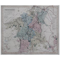
Antique Lithography Map, Worcestershire, English, Framed Engraving, Cartography
About the Item
This is an antique lithography map of Worcestershire. An English, framed atlas engraving of cartographic interest, dating to the early 19th century and later.
Superb lithography of Worcestershire and its county detail, perfect for display
Displaying a desirable aged patina and in very good order
Fascinating cartography, appealingly set within quality, later frames
Detail given to The Hundreds, the administrative divisions within counties until the mid 19th century
County emblems, and places of interest in colour add fine illustrative detail
Dressed to the rear with hanging cord for ease of mounting
This is a quality antique lithography map of Worcestershire, with fine cartographic interest. Delivered ready to display.
Dimensions:
Max Width: 33.5cm (13.25'')
Max Depth: 1.5cm (.5'')
Max Height: 40.5cm (16'')
- Dimensions:Height: 15.95 in (40.5 cm)Width: 13.19 in (33.5 cm)Depth: 0.6 in (1.5 cm)
- Style:Regency (Of the Period)
- Materials and Techniques:
- Place of Origin:
- Period:
- Date of Manufacture:circa 1800
- Condition:Wear consistent with age and use. Presented in very good antique condition.
- Seller Location:Hele, Devon, GB
- Reference Number:
About the Seller
5.0
Platinum Seller
These expertly vetted sellers are 1stDibs' most experienced sellers and are rated highest by our customers.
Established in 2005
1stDibs seller since 2017
833 sales on 1stDibs
Typical response time: 1 hour
- ShippingRetrieving quote...Ships From: Hele, Devon, United Kingdom
- Return PolicyA return for this item may be initiated within 14 days of delivery.
More From This SellerView All
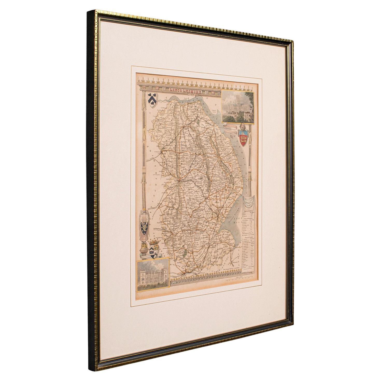
- Antique Lithography Map, Lincolnshire, English, Framed, Engraving, CartographyLocated in Hele, Devon, GBThis is an antique lithography map of Lincolnshire. An English, framed atlas engraving of cartographic interest, dating to the mid 19th century and...Category
Antique Mid-19th Century British Victorian Maps
MaterialsWood
- Antique Lithography Map, Northumberland, English, Framed, Engraving, CartographyLocated in Hele, Devon, GBThis is an antique lithography map of Northumberland. An English, framed atlas engraving of cartographic interest, dating to the mid 19th century a...Category
Antique Mid-19th Century British Victorian Maps
MaterialsWood
- Antique Lithography Map, Bedfordshire, English, Framed Engraving, CartographyLocated in Hele, Devon, GBThis is an antique lithography map of Bedfordshire. An English, framed atlas engraving of cartographic interest, dating to the mid 19th century and...Category
Antique Mid-19th Century British Victorian Maps
MaterialsWood
- Antique Lithography Map, Hertfordshire, English, Framed Engraving, CartographyLocated in Hele, Devon, GBThis is an antique lithography map of Hertfordshire. An English, framed atlas engraving of cartographic interest, dating to the mid 19th century an...Category
Antique Mid-19th Century British Victorian Maps
MaterialsWood
- Antique Lithography Map, Gloucestershire, English, Framed Engraving, CartographyLocated in Hele, Devon, GBThis is an antique lithography map of Gloucestershire. An English, framed atlas engraving of cartographic interest, dating to the mid 19th century ...Category
Antique Mid-19th Century British Victorian Maps
MaterialsWood
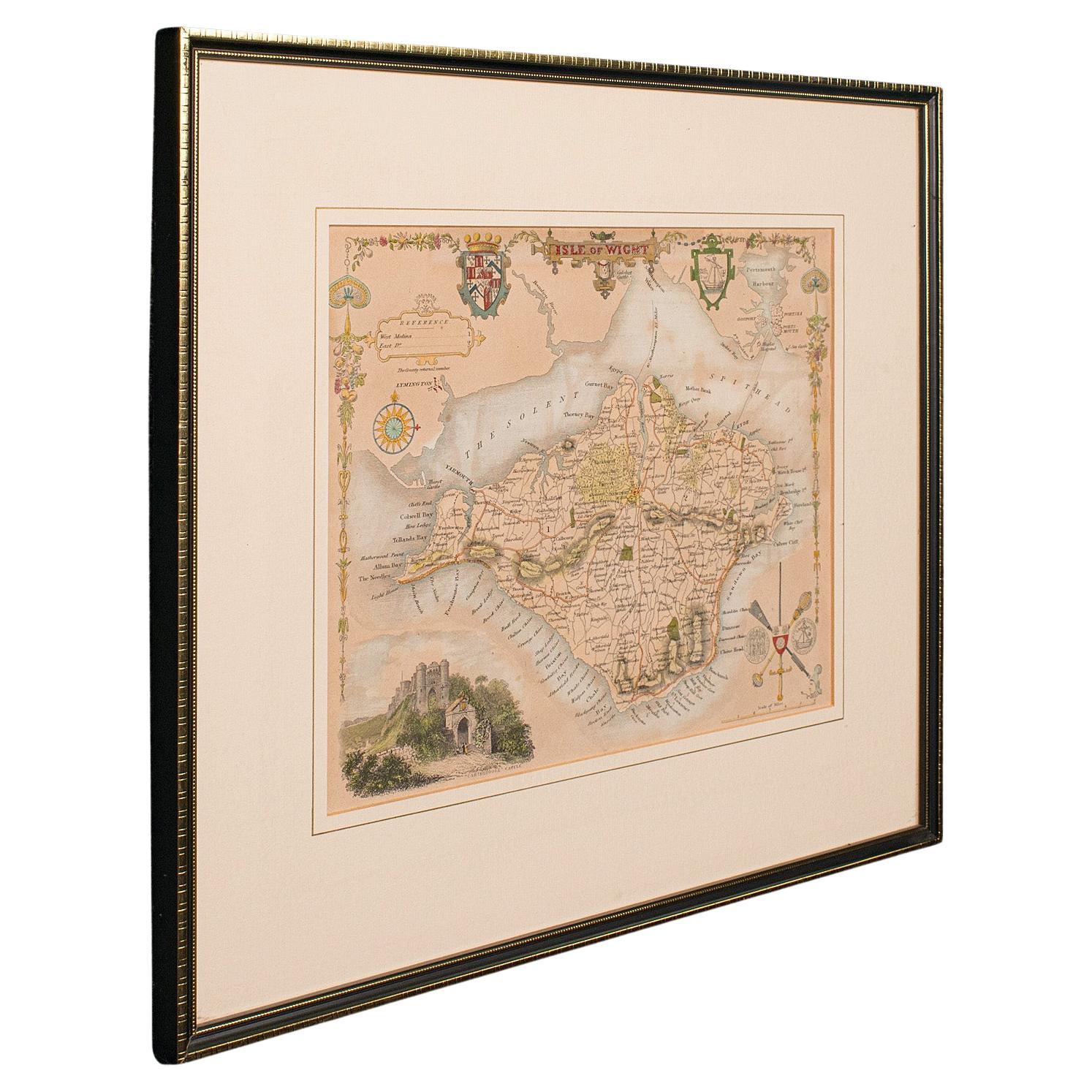
- Antique Lithography Map, Isle of Wight, English, Framed, Engraving, CartographyLocated in Hele, Devon, GBThis is an antique lithography map of the Isle of Wight. An English, framed atlas engraving of cartographic interest, dating to the early 19th century and later. Superb lithography ...Category
Antique Early 19th Century British Regency Maps
MaterialsWood


You May Also Like
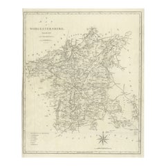
- Original Antique English County Map, Worcestershire, J & C Walker, 1851Located in St Annes, LancashireGreat map of Worcestershire Original colour By J & C Walker Published by Longman, Rees, Orme, Brown & Co. 1851 Unframed.Category
Antique 1850s English Other Maps
MaterialsPaper
- Large Antique County Map of Worcestershire, EnglandLocated in Langweer, NLAntique map titled 'A Map of Worcestershire from the best Authorities'. Original old county map of Worcestershire, England. Engraved by John Cary. Originates from 'New British Atlas'...Category
Antique Early 19th Century Maps
MaterialsPaper
- Cartographic Tapestry: Antique Map of Asia Minor, circa 1640Located in Langweer, NLTitle: "Historical Tapestry: Antique Map of Asia Minor, circa 1640" Description: This authentic antique map, created by Willem Blaeu and published in Amsterdam circa 1640, is a capt...Category
Antique Mid-17th Century Maps
MaterialsPaper
- Cartographic Elegance of the Mughal Dominion in a Hand-Colored Antique Map, 1705Located in Langweer, NLThis original antique map titled “'T Ryk van den Grooten Mogol” by Nicolas Sanson from 1705 is an interesting historical artifact. It depicts the extent of the Mughal Empire in North...Category
Antique Early 1700s Maps
MaterialsPaper
- Burgundy's Viticultural Landscape: A 1640 Cartographic Engraving by Willem BlaeuLocated in Langweer, NLAn hand-colored original antique map with the title "Utriusque Burgundiae tum Ducatus tum Comitatus Descriptio," which translates to "A Description of Both Burgundies, both the Duchy...Category
Antique 1640s Maps
MaterialsPaper
- Matthaus Seutter, Framed 1730 Color Engraving Map of "Belgium Fonderatum"Located in Bridgeport, CTLabel on verso. From Grosser Atlas. The name Belgium comes from the ancient designation "Gallis Belgica". Figural decoration upper left. M. Seutter was a famed German mapmaker in the...Category
Antique 18th Century European Renaissance Maps
MaterialsBrass