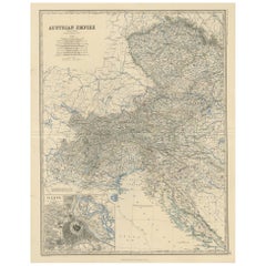
Antique Map of the Austrian Empire ‘West’ by A.K. Johnston, 1865
View Similar Items


Want more images or videos?
Request additional images or videos from the seller
1 of 5
Antique Map of the Austrian Empire ‘West’ by A.K. Johnston, 1865
About the Item
- Dimensions:Height: 24.41 in (62 cm)Width: 19.1 in (48.5 cm)Depth: 0.02 in (0.5 mm)
- Materials and Techniques:
- Period:
- Date of Manufacture:1865
- Condition:General age-related toning. Please study image carefully.
- Seller Location:Langweer, NL
- Reference Number:Seller: BG-05553/201stDibs: LU3054310726733
About the Seller
5.0
Recognized Seller
These prestigious sellers are industry leaders and represent the highest echelon for item quality and design.
Platinum Seller
Premium sellers with a 4.7+ rating and 24-hour response times
Established in 2009
1stDibs seller since 2017
2,433 sales on 1stDibs
Typical response time: 1 hour
Authenticity Guarantee
In the unlikely event there’s an issue with an item’s authenticity, contact us within 1 year for a full refund. DetailsMoney-Back Guarantee
If your item is not as described, is damaged in transit, or does not arrive, contact us within 7 days for a full refund. Details24-Hour Cancellation
You have a 24-hour grace period in which to reconsider your purchase, with no questions asked.Vetted Professional Sellers
Our world-class sellers must adhere to strict standards for service and quality, maintaining the integrity of our listings.Price-Match Guarantee
If you find that a seller listed the same item for a lower price elsewhere, we’ll match it.Trusted Global Delivery
Our best-in-class carrier network provides specialized shipping options worldwide, including custom delivery.More From This Seller
View AllAntique Map of South-West Russia by A.K. Johnston, 1865
Located in Langweer, NL
Antique map titled 'South-West Russia showing the extent of the Kingdom of Poland previous to its partition in 1772'. This map originates from the ‘Royal Atlas of Modern Geography’ b...
Category
Antique Mid-19th Century Maps
Materials
Paper

$231 Sale Price
20% Off
Antique Map of Denmark by A.K. Johnston, 1865
Located in Langweer, NL
Antique map titled 'Denmark and the Duchies Schleswig, Holstein & Lauenburg; Hanover, Brunswick, Mecklenburg, Oldenburg, Anhalt and Lippe'. With an inset map of Iceland, Copenhagen a...
Category
Antique Mid-19th Century Maps
Materials
Paper

$254 Sale Price
20% Off
Antique Map of Sweden & Norway by A.K. Johnston '1865'
Located in Langweer, NL
Antique map titled 'Sweden & Norway (Scandinavia)'. With an inset map of Stockholm and environments. This map originates from the ‘Royal Atlas of Modern Geography’ by Alexander Keith...
Category
Antique Mid-19th Century Maps
Materials
Paper

$254 Sale Price
20% Off
Antique Map of South Australia by A.K. Johnston, 1865
Located in Langweer, NL
Antique map titled 'South Australia, New South Wales, Victoria & Queensland'. This map originates from the ‘Royal Atlas of Modern Geography’ by Alexander Keith Johnston. Published by...
Category
Antique Mid-19th Century Maps
Materials
Paper

$277 Sale Price
20% Off
Antique Map of Belgium and The Netherlands by A.K. Johnston, 1865
Located in Langweer, NL
Antique map titled 'Belgium and The Netherlands'. This map originates from the ‘Royal Atlas of Modern Geography’ by Alexander Keith Johnston. Published by William Blackwood and Sons,...
Category
Antique Mid-19th Century Maps
Materials
Paper
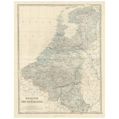
$254 Sale Price
20% Off
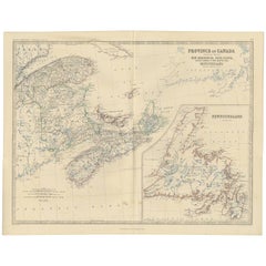
Antique Map of the Province of Canada 'East' by A.K. Johnston, 1865
Located in Langweer, NL
Antique map titled 'Province of Canada (Eastern Sheet)'. Depicting New Brunswick, Newfoundland, Cape Breton Island, Prince Edward Island, Nova Scotia and m...
Category
Antique Mid-19th Century Maps
Materials
Paper
$240 Sale Price
20% Off
You May Also Like
Original Antique Map of The World by Thomas Clerk, 1817
Located in St Annes, Lancashire
Great map of The Eastern and Western Hemispheres
On 2 sheets
Copper-plate engraving
Drawn and engraved by Thomas Clerk, Edinburgh.
Published by Mackenzie And Dent, 1817
...
Category
Antique 1810s English Maps
Materials
Paper

Map of the Republic of Genoa
Located in New York, NY
Framed antique hand-coloured map of the Republic of Genoa including the duchies of Mantua, Modena, and Parma.
Europe, late 18th century.
Dimension: 25...
Category
Antique Late 18th Century European Maps

Antique Map of Italy by Andriveau-Goujon, 1843
By Andriveau-Goujon
Located in New York, NY
Antique Map of Italy by Andriveau-Goujon, 1843. Map of Italy in two parts by Andriveau-Goujon for the Library of Prince Carini at Palazzo Carini i...
Category
Antique 1840s French Maps
Materials
Linen, Paper

$3,350 / set
Antique Map of Principality of Monaco
By Antonio Vallardi Editore
Located in Alessandria, Piemonte
ST/619 - "Old Geographical Atlas of Italy - Topographic map of ex-Principality of Monaco" -
ediz Vallardi - Milano -
A somewhat special edition ---
Category
Antique Late 19th Century Italian Other Prints
Materials
Paper

17th Century Hand-Colored Map of a Region in West Germany by Janssonius
By Johannes Janssonius
Located in Alamo, CA
This attractive highly detailed 17th century original hand-colored map is entitled "Archiepiscopatus Maghdeburgensis et Anhaltinus Ducatus cum terris adjacentibus". It was published ...
Category
Antique Mid-17th Century Dutch Maps
Materials
Paper

West Coast of Africa, Guinea & Sierra Leone: An 18th Century Map by Bellin
By Jacques-Nicolas Bellin
Located in Alamo, CA
Jacques Bellin's copper-plate map entitled "Partie de la Coste de Guinee Dupuis la Riviere de Sierra Leona Jusquau Cap das Palmas", depicting the coast of Guinea and Sierra Leone in ...
Category
Antique Mid-18th Century French Maps
Materials
Paper
