
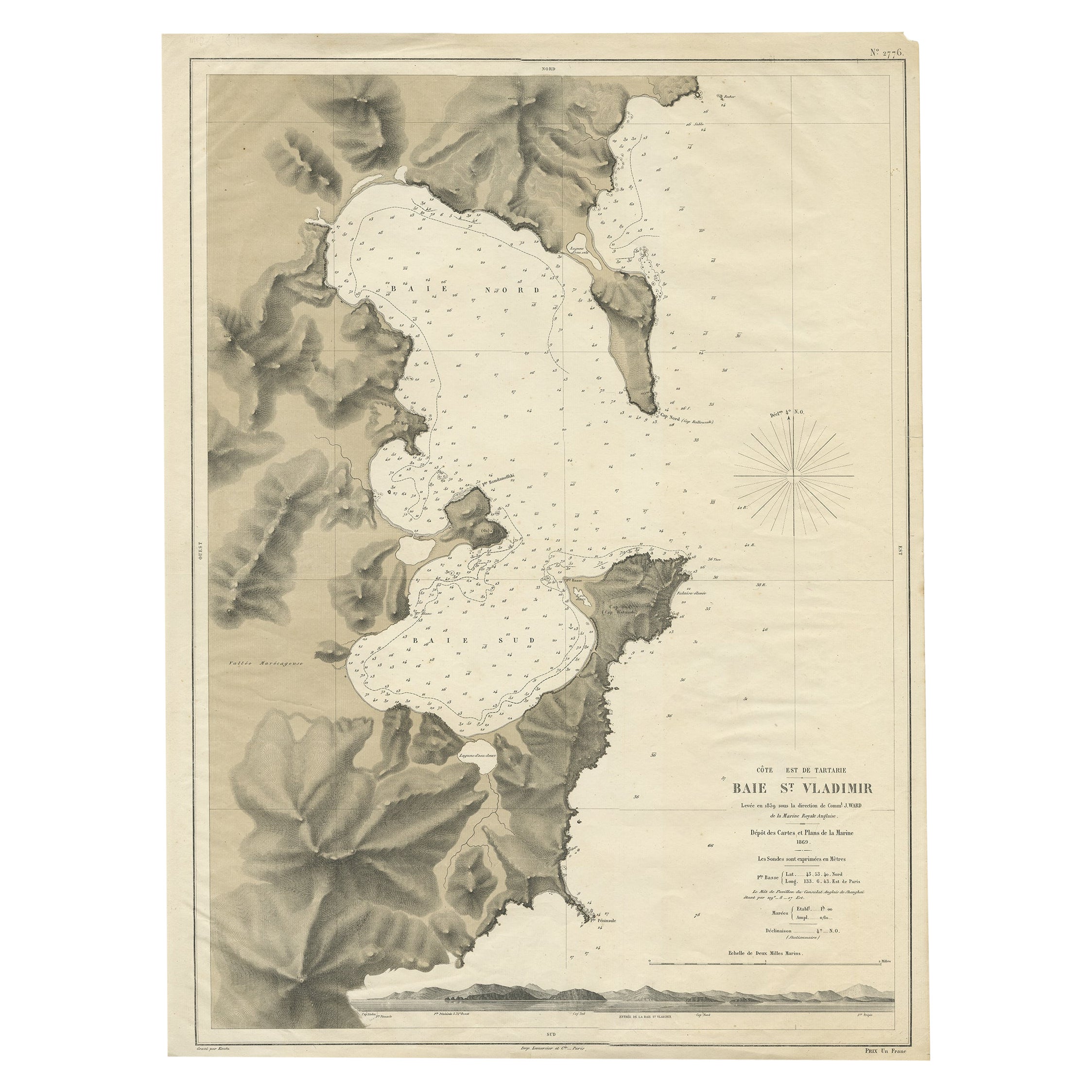
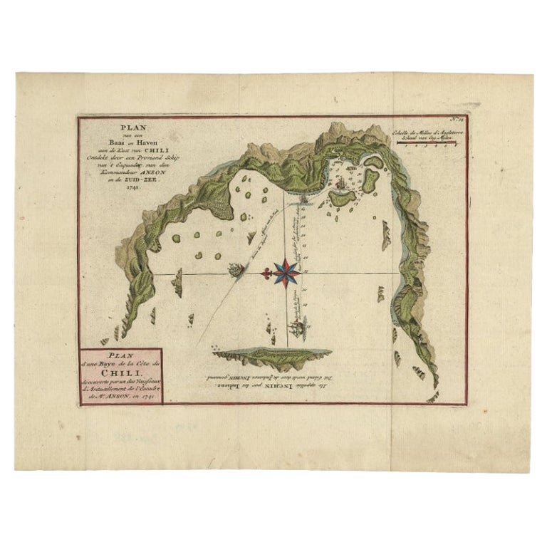
Antique Map of the Bay of St. Vladimir by Kautz, 1869
View Similar Items


Want more images or videos?
Request additional images or videos from the seller
1 of 5
Antique Map of the Bay of St. Vladimir by Kautz, 1869
About the Item
- Dimensions:Height: 26.38 in (67 cm)Width: 19.3 in (49 cm)Depth: 0 in (0.01 mm)
- Materials and Techniques:
- Period:
- Date of Manufacture:1869
- Condition:
- Seller Location:Langweer, NL
- Reference Number:Seller: BG-007021stDibs: LU3054327775102
About the Seller
5.0
Recognized Seller
These prestigious sellers are industry leaders and represent the highest echelon for item quality and design.
Platinum Seller
Premium sellers with a 4.7+ rating and 24-hour response times
Established in 2009
1stDibs seller since 2017
2,442 sales on 1stDibs
Typical response time: 1 hour
Authenticity Guarantee
In the unlikely event there’s an issue with an item’s authenticity, contact us within 1 year for a full refund. DetailsMoney-Back Guarantee
If your item is not as described, is damaged in transit, or does not arrive, contact us within 7 days for a full refund. Details24-Hour Cancellation
You have a 24-hour grace period in which to reconsider your purchase, with no questions asked.Vetted Professional Sellers
Our world-class sellers must adhere to strict standards for service and quality, maintaining the integrity of our listings.Price-Match Guarantee
If you find that a seller listed the same item for a lower price elsewhere, we’ll match it.Trusted Global Delivery
Our best-in-class carrier network provides specialized shipping options worldwide, including custom delivery.More From This Seller
View AllRare Map of the Bay of St. Vladimir 'Russia' Showing the Route of J. Ward, 1869
Located in Langweer, NL
Antique map titled 'Côte est de Tartarie Baie St. Vladimir'.
Map of the Bay of St. Vladimir (Russia) showing the route of J. Ward. Including a coastal view. Source unknown, to be...
Category
Antique 1860s Maps
Materials
Paper

$675 Sale Price
20% Off
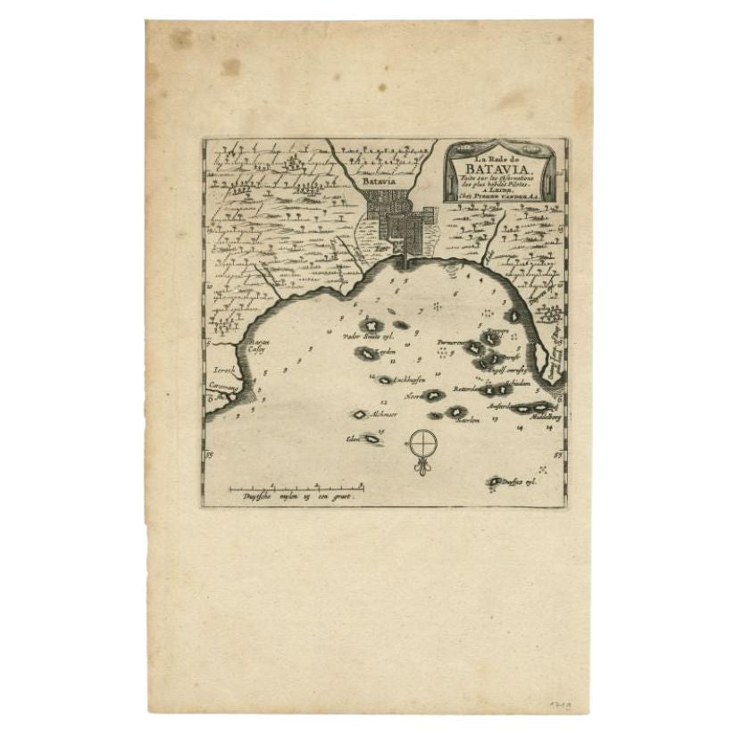
Antique Map of the Bay of Bantam, c.1720
Located in Langweer, NL
Rare, untitled miniature map of the Bay of Bantam with various Islands including Pulo Dua and Pulo Batto. This map originates from a small travelogue and may originate from an editio...
Category
Antique 18th Century Maps
Materials
Paper

$55 Sale Price
20% Off
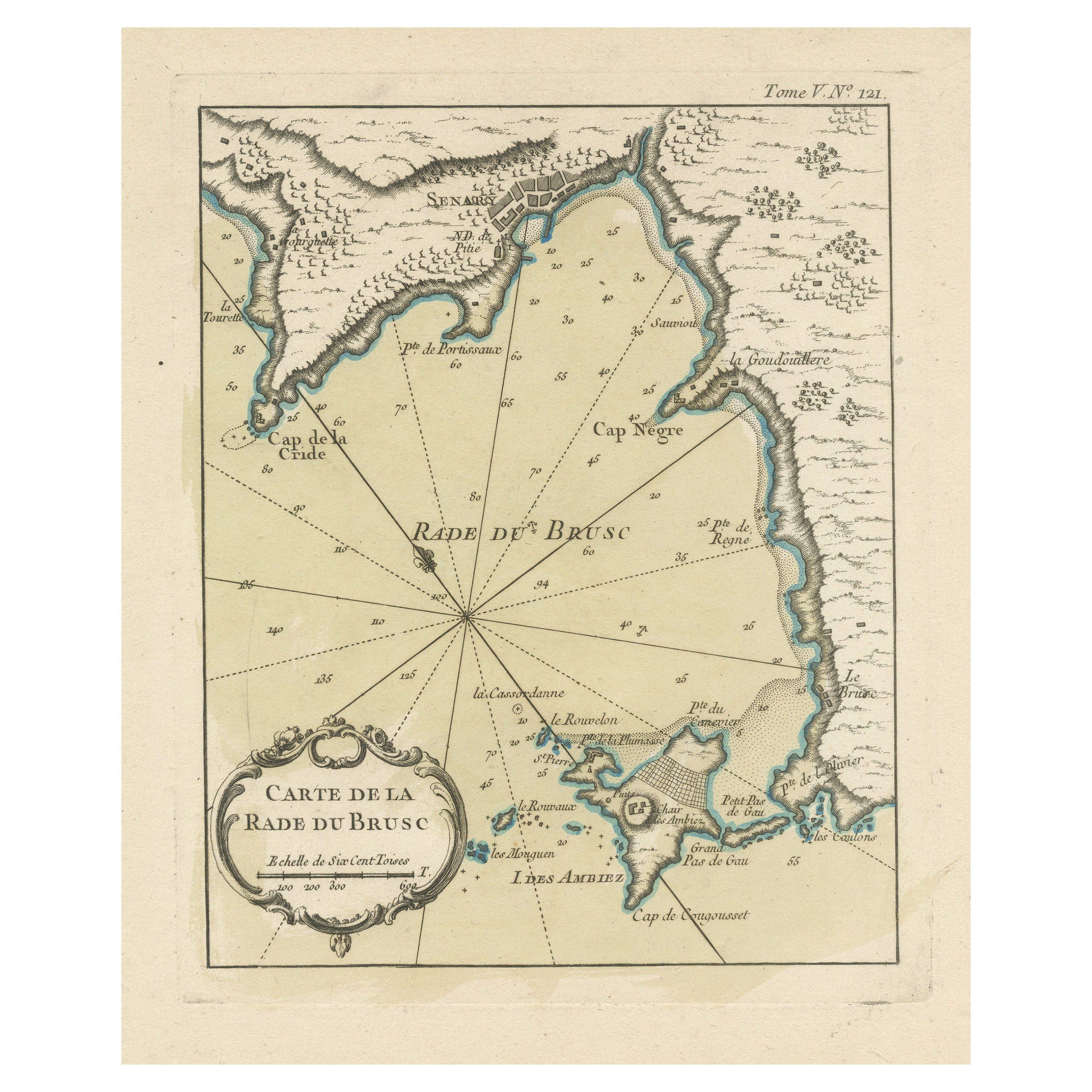
Antique Map of the Bay of Brusc, France
Located in Langweer, NL
Antique map titled 'Carte de la rade du Brusc'. Original map of the bay of Brusc, France. This map originates from 'Le Petit Atlas Maritime (..)' by J.N. Bellin. Published 1764.
...
Category
Antique Mid-18th Century Maps
Materials
Paper
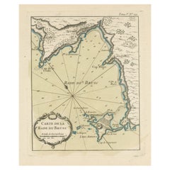
$314 Sale Price
20% Off
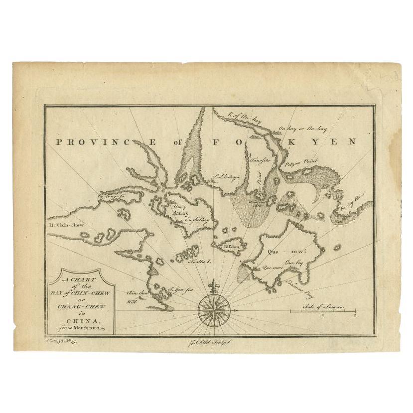
Antique Map of the Bay of Chin Chew by Child, 1747
Located in Langweer, NL
Antique map titled 'A Chart of the Bay of Chin-Chew or Chang-Chew in China'. Small but very early and interesting map, engraved by G. Child for 'The Universal Traveller', by Thomas S...
Category
Antique 18th Century Maps
Materials
Paper
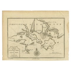
$157 Sale Price
20% Off
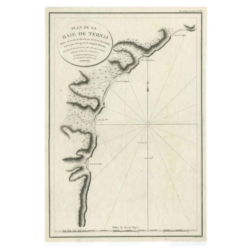
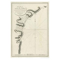
Antique Map of the Bay of Terney by La Pérouse, 1797
Located in Langweer, NL
Antique map titled 'Plan de la Baie de Ternai'. Old map of the north eastern coast of Russia. This map originates from 'Atlas du voyage de La Perouse'. Arti...
Category
Antique 18th Century Maps
Materials
Paper
$141 Sale Price
20% Off
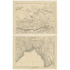
Antique Map of the Region of the Bay of Bengal by Lowry, 1852
Located in Langweer, NL
Two individual sheets of the region of the Bay of Bengal. This map originates from 'Lowry's table Atlas constructed and engraved from the most recent aut...
Category
Antique Mid-19th Century Maps
Materials
Paper
$138 Sale Price / set
20% Off
You May Also Like
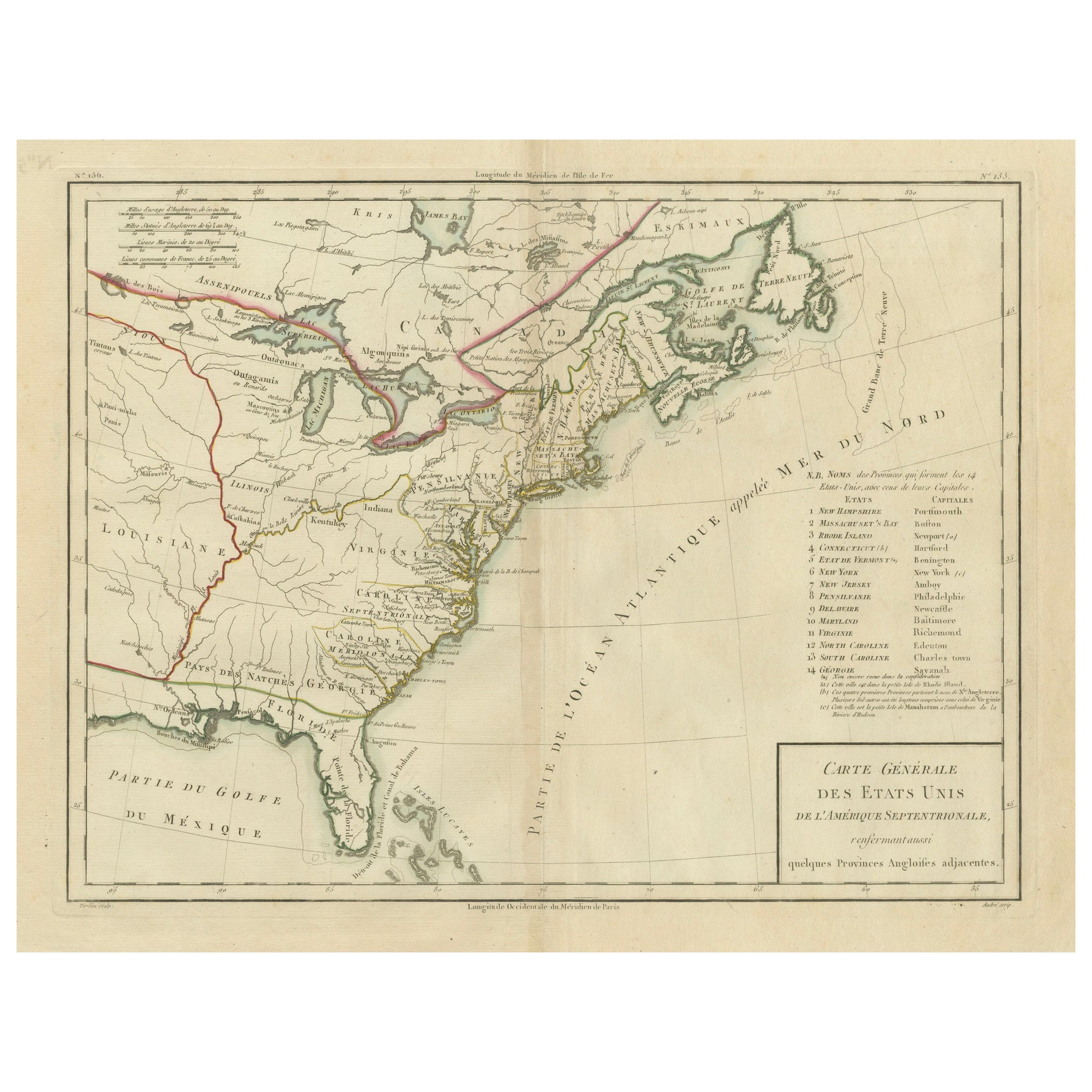
1856 U.S. Coast Survey Map of Chesapeake Bay and Delaware Bay
Located in Colorado Springs, CO
Presented is U.S. Coast Survey nautical chart or maritime map of Chesapeake Bay and Delaware Bay from 1856. The map depicts the region from Susquehanna, Maryland to the northern Outer Banks in North Carolina. It also shows from Richmond and Petersburg, Virginia to the Atlantic Ocean. The map is highly detailed with many cities and towns labeled throughout. Rivers, inlets, and bays are also labeled. Various charts illustrating more specific parts of the region are marked on the map using dotted lines. The lines form boxes, and the corresponding chart number and publication date are given. Extensive triangulation surveys were conducted the length of Chesapeake Bay and are illustrated here. Hampton Roads, Virginia is labeled, along with the James, York, and Rappahannock Rivers, which were all extensively surveyed.
The chart was published under the supervision of A. D. Bache, one of the most influential and prolific figures in the early history of the U.S. Coast Survey, for the 1856 Report of the Superintendent of the U.S. Coast Survey. Alexander Dallas Bache (1806-1867) was an American physicist, scientist, and surveyor. Bache served as the Superintendent of the U.S. Coast Survey from 1843 to 1865. Born in Philadelphia, Bache toured Europe and composed an important treatise on European Education. He also served as president of Philadelphia's Central High School and was a professor of natural history and chemistry at the University of Pennsylvania. Upon the death of Ferdinand Rudolph Hassler, Bache was appointed Superintendent of the United States Coast Survey.
The Office of the Coast Survey, founded in 1807 by President Thomas Jefferson and Secretary of Commerce Albert Gallatin...
Category
Antique 1850s American Maps
Materials
Paper

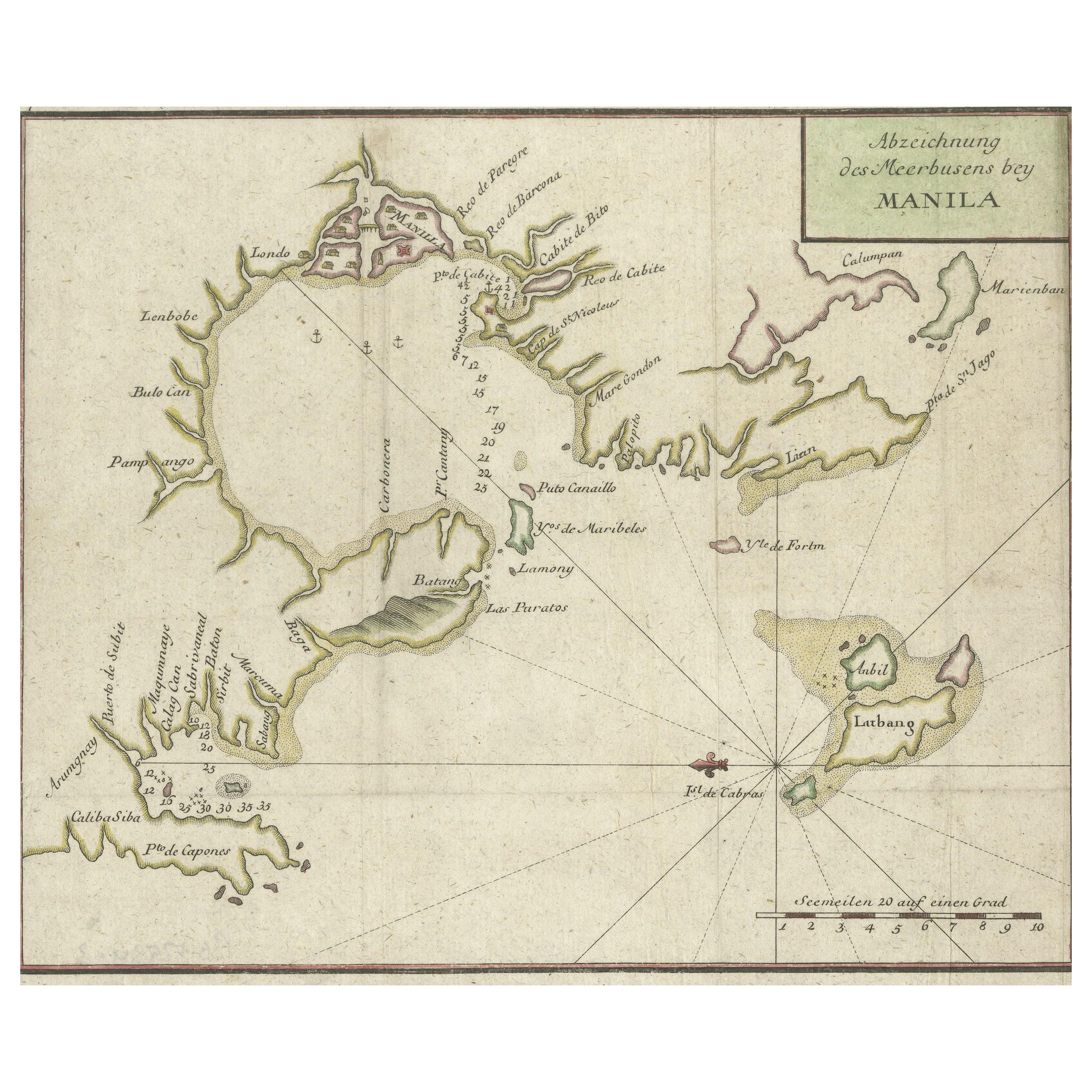
Original Antique Map of The Philippines. C.1900
Located in St Annes, Lancashire
Fabulous map of The Philippines
Original color.
Engraved and printed by the George F. Cram Company, Indianapolis.
Published, C.1900.
Unframed.
Free shipping.
Category
Antique 1890s American Maps
Materials
Paper

Original Antique Map of The World by Thomas Clerk, 1817
Located in St Annes, Lancashire
Great map of The Eastern and Western Hemispheres
On 2 sheets
Copper-plate engraving
Drawn and engraved by Thomas Clerk, Edinburgh.
Published by Mackenzie And Dent, 1817
...
Category
Antique 1810s English Maps
Materials
Paper

Large Original Antique Map of The Bahamas. 1894
Located in St Annes, Lancashire
Superb Antique map of The Bahamas
Published Edward Stanford, Charing Cross, London 1894
Original colour
Good condition
Unframed.
Free shipping
Category
Antique 1890s English Maps
Materials
Paper

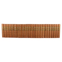
1869-86 The Novels of William Makepeace Thackeray
By William Makepeace Thackeray
Located in Bath, GB
A nicely bound fully illustrated collection of the works of William Makepeace Thackeray.
Complete in twenty-four volumes.
Volume I, 'Vanity Fair Volume I', published in 1869. Illustrated by the author with a frontispiece, a vignette title page, and nineteen plates. Collated, complete.
Volume II, 'Vanity Fair Volume II', published in 1869. Illustrated by the author with a frontispiece, and eighteen plates. Collated, complete.
Volume III, 'The History of Pendennis Volume I', published in 1869. Illustrated by the author with a frontispiece, vignette title page, and twenty-two plates. Collated, complete.
Volume IV, 'The History of Pendennis Volume II', published in 1869. Illustrated by the author with a frontispiece, a vignette title page, and twenty-two plates. Collated, complete.
Volume V, 'The Newcomers Volume I', published in 1869. Illustrated by Richard Doyle...
Category
Antique Late 19th Century British Books
Materials
Paper
Large Original Antique Map of the The Windward Islands. 1894
Located in St Annes, Lancashire
Superb Antique map of The Windward Islands
Published Edward Stanford, Charing Cross, London 1894
Original colour
Good condition
Unframed.
Free shipping
Category
Antique 1890s English Maps
Materials
Paper
