Items Similar to Antique Map of Brabant and part of Belgium by Munster, c.1580
Want more images or videos?
Request additional images or videos from the seller
1 of 5
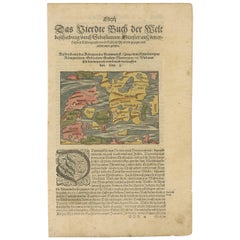
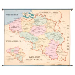
Antique Map of Brabant and part of Belgium by Munster, c.1580
About the Item
Antique map titled 'Braband'. Original woodcut print of the region of Brabant (the Netherlands) and part of Belgium. Charming miniature originating from 'Cosmographia' by S. Munster.
Artists and Engravers: Sebastian Munster was a German cartographer, cosmographer and Christian scholar. He is best known for Cosmographia, the earliest German description of the world (in 6 parts. He was also the author of Horologiographia, Organum Uranicum and Rudimenta Mathematica. The woodcuts in this publication were made by a group of artists, among which Hans Holbein, Conrad Schnitt, David Kandel and Hans Rudolf Manuel Deutsch.
Condition: Good, general age-related toning. Small crease/wrinkle. Frame included, with wear. Please study image carefully.
Date: c.1580
Overall size: 23 x 19.5 cm.
We sell original antique maps to collectors, historians, educators and interior decorators all over the world. Our collection includes a wide range of authentic antique maps from the 16th to the 20th centuries. Buying and collecting antique maps is a tradition that goes back hundreds of years. Antique maps have proved a richly rewarding investment over the past decade, thanks to a growing appreciation of their unique historical appeal. Today the decorative qualities of antique maps are widely recognized by interior designers who appreciate their beauty and design flexibility. Depending on the individual map, presentation, and context, a rare or antique map can be modern, traditional, abstract, figurative, serious or whimsical. We offer a wide range of authentic antique maps for any budget.
- Dimensions:Height: 7.68 in (19.5 cm)Width: 9.06 in (23 cm)Depth: 0 in (0.01 mm)
- Materials and Techniques:
- Period:
- Date of Manufacture:c.1580
- Condition:
- Seller Location:Langweer, NL
- Reference Number:Seller: BG-000671stDibs: LU3054326083082
About the Seller
5.0
Platinum Seller
These expertly vetted sellers are 1stDibs' most experienced sellers and are rated highest by our customers.
Established in 2009
1stDibs seller since 2017
1,947 sales on 1stDibs
Typical response time: <1 hour
- ShippingRetrieving quote...Ships From: Langweer, Netherlands
- Return PolicyA return for this item may be initiated within 14 days of delivery.
More From This SellerView All
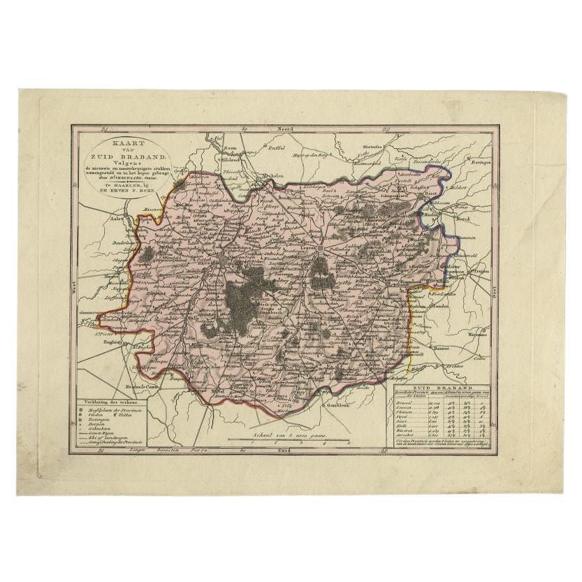
- Antique Map of the Province of Brabant in Belgium by Veelwaard, C.1840Located in Langweer, NLAntique map titled 'Kaart van Zuid Braband (..).' Uncommon map showing the province of Zuid-Brabant in Belgium. Source unknown, to be determined. Artists and Engravers: Daniel Vee...Category
Antique 19th Century Maps
MaterialsPaper
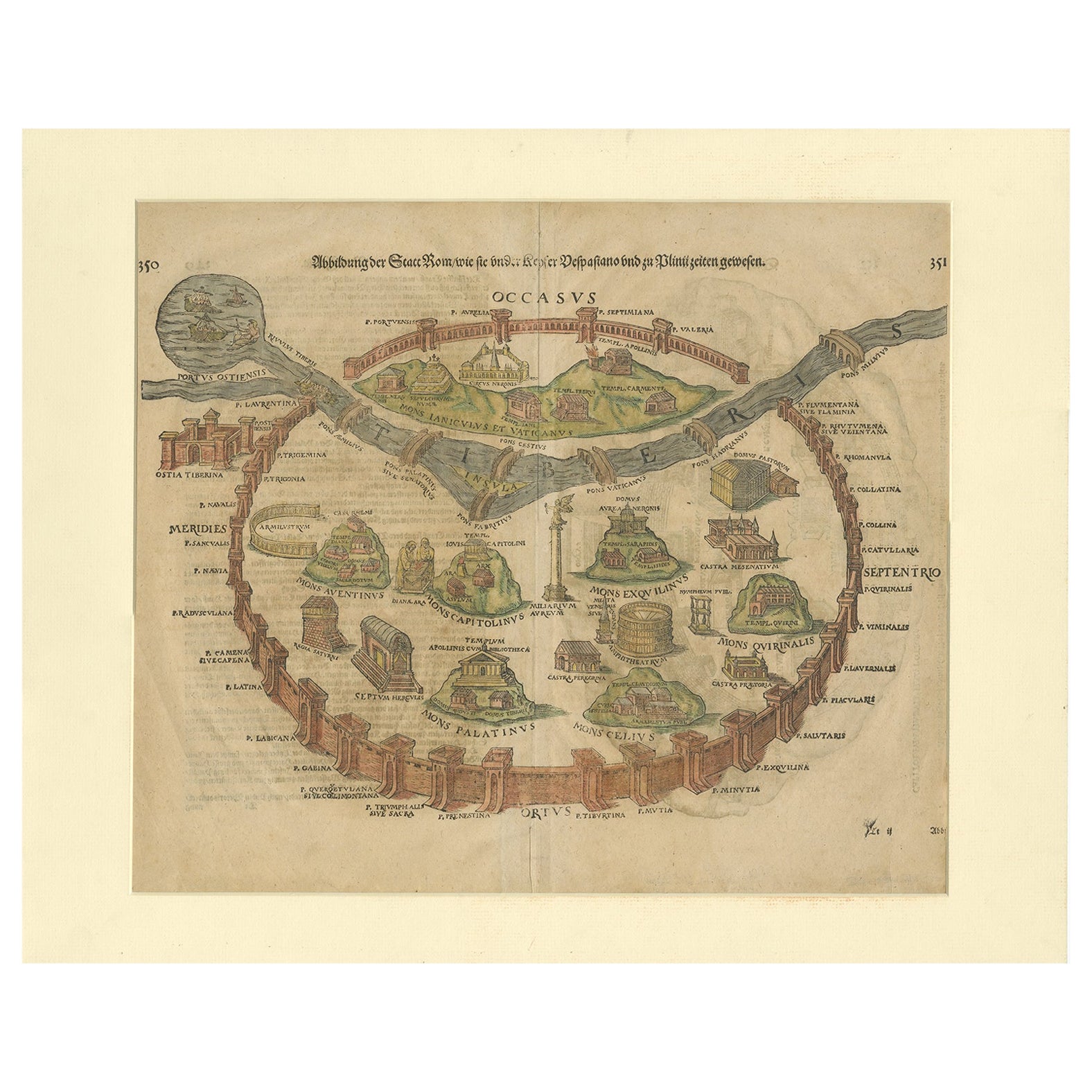
- Antique Print of the City of Rome, Italy by Münster, C.1580Located in Langweer, NLAntique print titled 'Abbildung der Statt Rom/wie sie under Keyser Vespasiano und zu Plinii zeiten gewesen'. Woodcut of ancient Rome. This print originates from Munster's Cosmographi...Category
Antique 16th Century Prints
MaterialsPaper
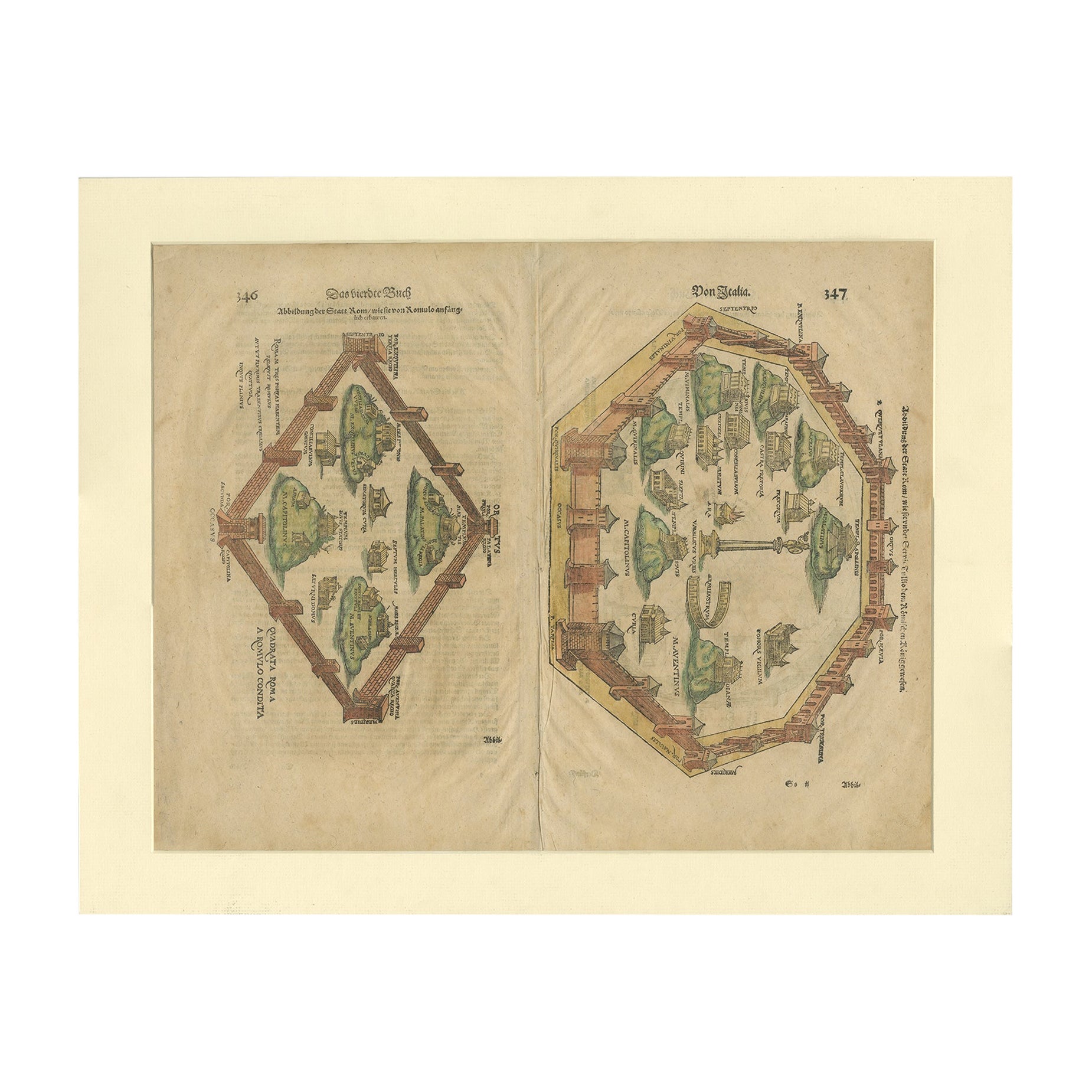
- Antique Print of the City of Rome, Italy by Münster, C.1580Located in Langweer, NLAntique print titled 'Abbildung der Statt Rom/wie sie von Romulo anfänge - Von Italia'. Woodcut of ancient Rome. This print originates from Munster's Cosmographia, one of the most in...Category
Antique 16th Century Prints
MaterialsPaper
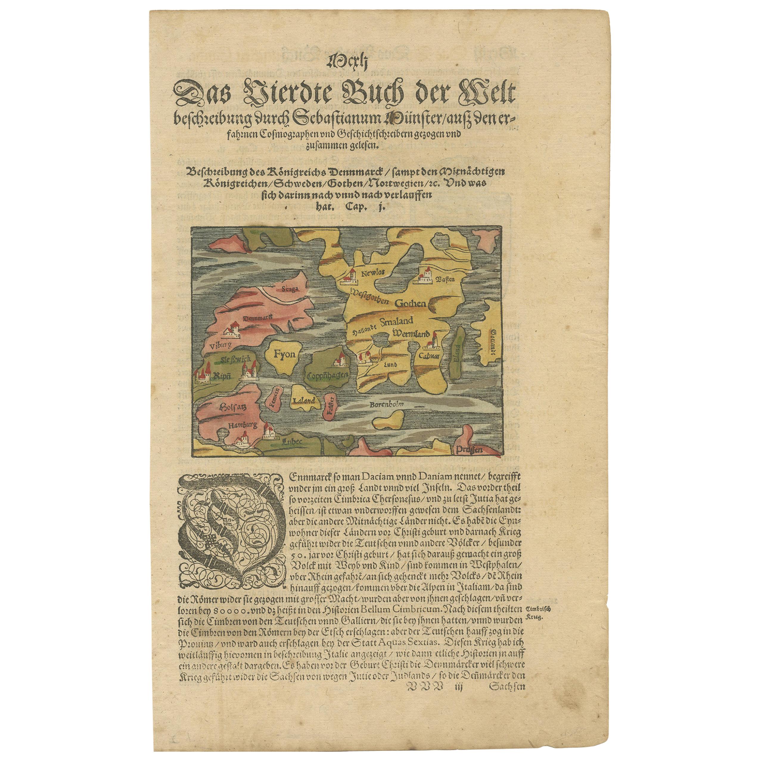
- Antique Map of Denmark by Münster '1588'Located in Langweer, NLAntique map titled 'Beschreibung des Königreichs Dennmarck (..)'. Early map of Denmark. This map originates from 'Cosmographey Oder beschreibung Aller Länder (..)' by Sebastian Münster.Category
Antique 16th Century Maps
MaterialsPaper
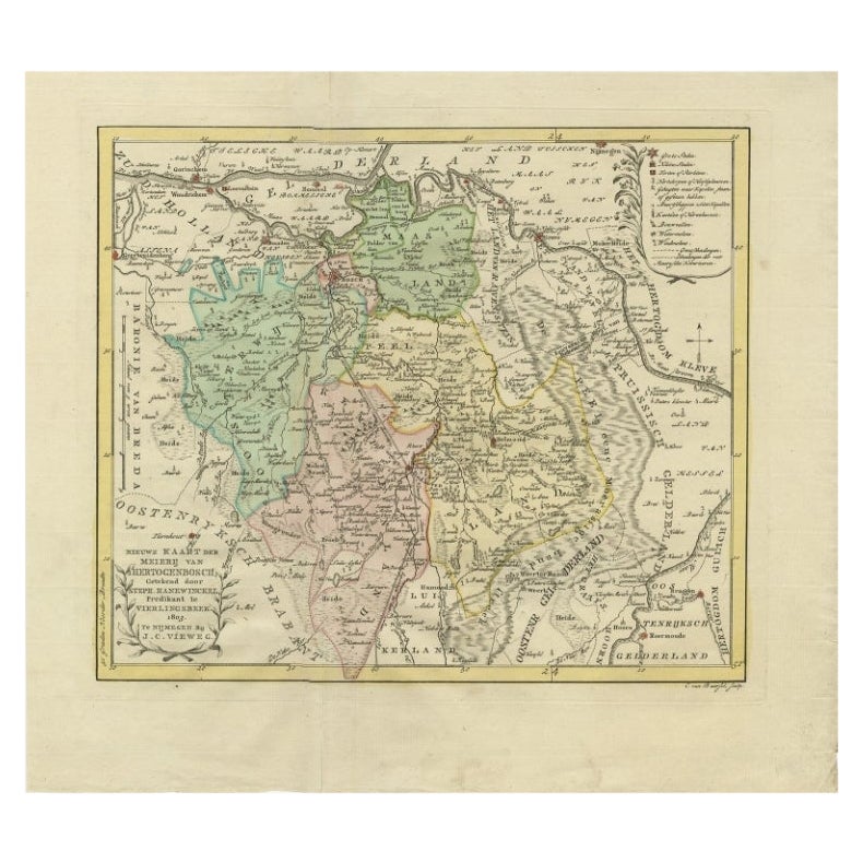
- Antique Map of Part of the Former Duchy of Brabant by Van Baarsel, 1803Located in Langweer, NLAntique map titled 'Nieuwe Kaart der Meierij van s Hertogenbosch (..).' Map of 'The Meierij van 's-Hertogenbosch', (Dutch for Bailiwick of Bois le Duc), it was one of the four parts ...Category
Antique 19th Century Maps
MaterialsPaper
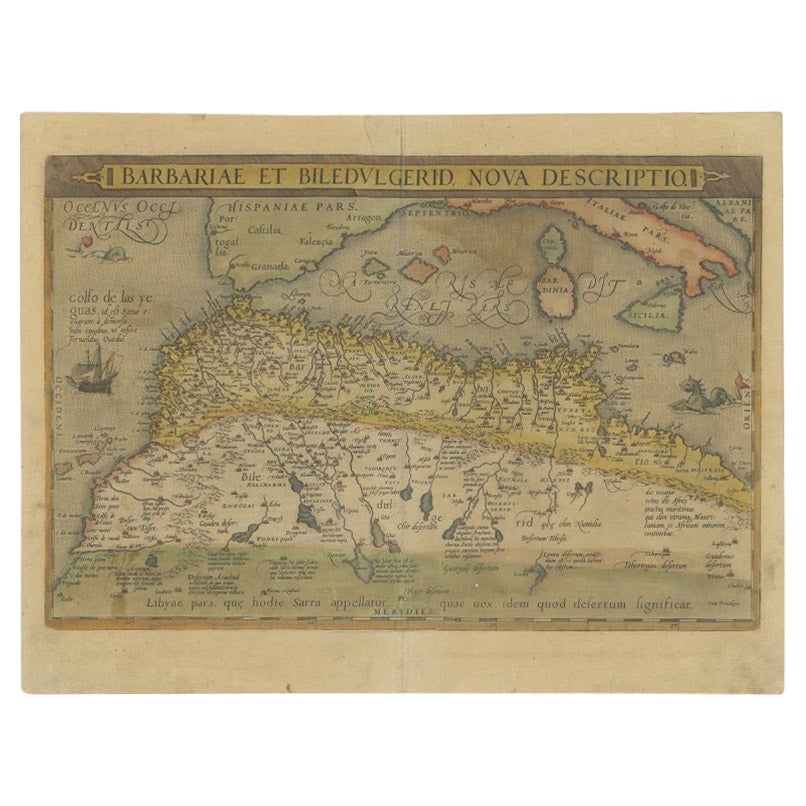
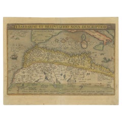
- Antique Map of North Africa by Ortelius, c.1580Located in Langweer, NLAntique map titled 'Barbariae et Biledulgerid Nova Descriptio'. Original antique map of North Africa. The map covers the regions of Barbaria and Biledulgerid, essentially the territo...Category
Antique 16th Century Maps
MaterialsPaper
You May Also Like
- Original Antique Map of Belgium by Tallis, Circa 1850Located in St Annes, LancashireGreat map of Belgium Steel engraving Many lovely vignettes Published by London Printing & Publishing Co. ( Formerly Tallis ), C.1850 Origin...Category
Antique 1850s English Maps
MaterialsPaper
- 1844 Map "Russia in Eurpoe, Part II to Part VIII", 7 Maps Ric.r023Located in Norton, MA1844 Map "Russia in Eurpoe, Part II to Part VIII" 7 Maps Ric.r023 Fine, original, steel-engraved Map of Russia in Europe Part II t oPart VIII, by the Society for the Diffusion of Useful Knowledge. Detailed map of the regions to the northeast of Moscow. Including Arkhangel, Vologda, Viatka, Perm, Olonetz, Iaroslavl. The SDUK began its map publishing project under the leadership of Captain Francis Beaufort R.N. in 1829, and published the maps in parts, haltingly, over the next 15 years, completing the series in 1844, finally permitting the publication of a whole atlas. Many of the maps were actually drawn by Beaufort, who at the time was the Hydrographer to the Royal Navy, and all were closely supervised by him. J. & C. Walker worked closely with Beaufort in engraving the maps. Finely engraved, carefully researched, the maps set...Category
Antique 19th Century Unknown Maps
MaterialsPaper
- XL Old School Map of Belgium 'Printed by Procure', 1950sLocated in Oostende, BEXL Old school map of Belgium (Printed by Procure). Presumably from around 1950-1960.Category
Vintage 1950s Belgian Mid-Century Modern Maps
MaterialsMetal
- Map of the Kingdom of Sardinia and Part of the Kingdom of Genoa, RomeBy Giovanni Maria CassiniLocated in Hamilton, Ontario18th century map by Italian engraver Giovanni Maria Cassini (Italy 1745-1824). Map of Part of the Kingdom of Sardinia and Part of the Kingdom of Genoa: Rome. This is a hand colored a...Category
Antique 18th Century Italian Maps
MaterialsPaper
- 1907 Map of Colorado, Antique Topographical Map, by Louis NellLocated in Colorado Springs, COThis highly detailed pocket map is a topographical map of the state of Colorado by Louis Nell from 1907. The map "has been complied from all availabl...Category
Antique Early 1900s American Maps
MaterialsPaper
- 1861 Topographical Map of the District of Columbia, by Boschke, Antique MapLocated in Colorado Springs, COPresented is an original map of Albert Boschke's extremely sought-after "Topographical Map of the District of Columbia Surveyed in the Years 1856 ...Category
Antique 1860s American Historical Memorabilia
MaterialsPaper


Recently Viewed
View AllMore Ways To Browse
David Deutsch
Sebastian Munster
Antique Map Munster
Antique Texas Furniture
Texas Antique Furniture
Cross Decor
Antique Large Maps
Britain Map
American West Antiques
Antique Furniture Long Island
Antique Maps London
London Antique Map
London Map Antique
Antique London Maps
Antique London Map
Antique Map London
London Antique Maps
Ship Map