Items Similar to Antique Map of Denmark, Iceland and the Faroe Islands by Migeon, 1880
Want more images or videos?
Request additional images or videos from the seller
1 of 6
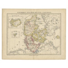
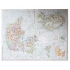
Antique Map of Denmark, Iceland and the Faroe Islands by Migeon, 1880
About the Item
Antique map titled 'Danemark, Islande et Iles Faeröe'. Old map of Denmark, Iceland and the Faroe Islands. With decorative vignette of the Kronborgh Castle and three inset maps of Island, the Bornholm and the Faeroe Islands. This map originates from 'Géographie Universelle Atlas-Migeon' by J. Migeon.
Artists and Engravers: Published by J. Migeon. Reviewed by A. Vuillemin. Alexandre Vuillemin (1812-1880) was a cartographer and an book editor based in Paris, France.
Condition: Good, age-related toning. Please study image carefully.
Date: 1880
Overall size: 34.5 x 47.5 cm.
Image size: 28 x 37 cm.
We sell original antique maps to collectors, historians, educators and interior decorators all over the world. Our collection includes a wide range of authentic antique maps from the 16th to the 20th centuries. Buying and collecting antique maps is a tradition that goes back hundreds of years. Antique maps have proved a richly rewarding investment over the past decade, thanks to a growing appreciation of their unique historical appeal. Today the decorative qualities of antique maps are widely recognized by interior designers who appreciate their beauty and design flexibility. Depending on the individual map, presentation, and context, a rare or antique map can be modern, traditional, abstract, figurative, serious or whimsical. We offer a wide range of authentic antique maps for any budget.
- Dimensions:Height: 18.71 in (47.5 cm)Width: 13.59 in (34.5 cm)Depth: 0 in (0.01 mm)
- Materials and Techniques:
- Period:
- Date of Manufacture:1880
- Condition:
- Seller Location:Langweer, NL
- Reference Number:
About the Seller
5.0
Platinum Seller
These expertly vetted sellers are 1stDibs' most experienced sellers and are rated highest by our customers.
Established in 2009
1stDibs seller since 2017
1,928 sales on 1stDibs
Typical response time: <1 hour
- ShippingRetrieving quote...Ships From: Langweer, Netherlands
- Return PolicyA return for this item may be initiated within 14 days of delivery.
More From This SellerView All
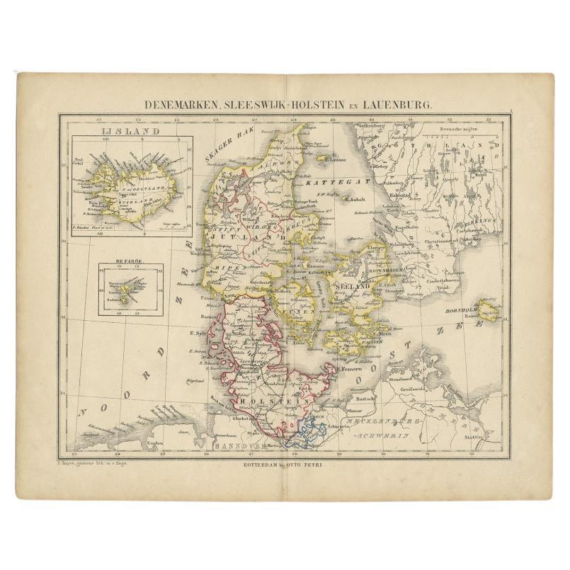
- Antique Map of Denmark with Insets of Iceland and the Faroe Islands, c.1873Located in Langweer, NLAntique map titled 'Denemarken, Sleeswijk-Holstein en Lauenburg'. Old map depicting Denmark, with inset maps of Iceland and the Faroe Islands. This map originates from 'School-Atlas ...Category
Antique 19th Century Maps
MaterialsPaper
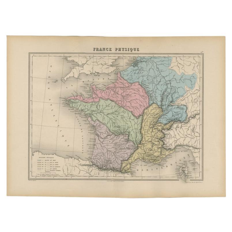
- Antique Map of France by Migeon, 1880Located in Langweer, NLAntique map titled 'France Physique'. Old map of France. This map originates from 'Géographie Universelle Atlas-Migeon' by J. Migeon. Artists and Engravers: Published by J. Migeon...Category
Antique 19th Century Maps
MaterialsPaper
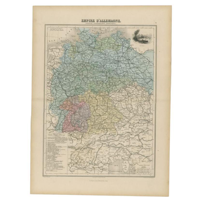
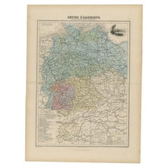
- Antique Map of the German Empire by Migeon, 1880Located in Langweer, NLAntique map titled 'Empire d'Allemagne'. Old map of Germany. With decorative vignette of Mainz. This map originates from 'Géographie Universelle Atlas-Migeon' by J. Migeon. Artist...Category
Antique 19th Century Maps
MaterialsPaper
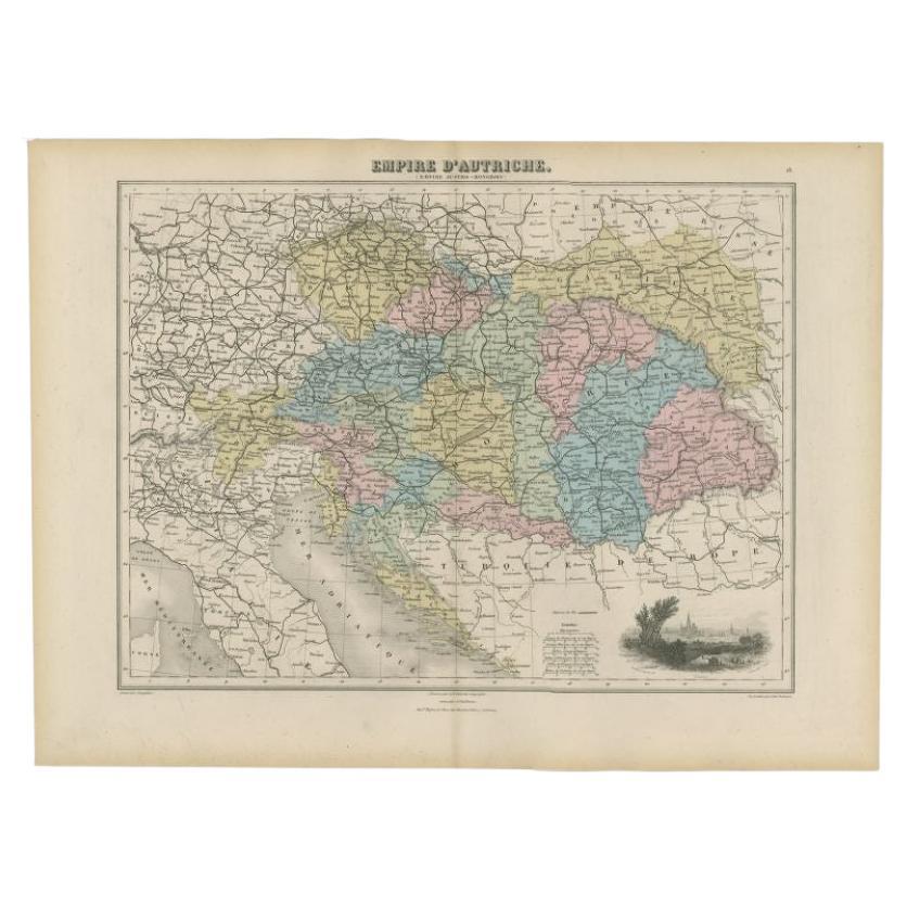
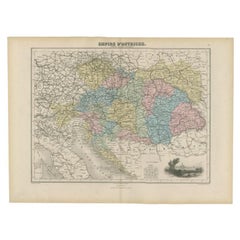
- Antique Map of the Austrian Empire by Migeon, 1880Located in Langweer, NLAntique map titled 'Empire d'Autriche'. Old map of the Austrian Empire. With decorative vignette with a view of Vienna. This map originates from 'Géographie Universelle Atlas-Migeon'...Category
Antique 19th Century Maps
MaterialsPaper
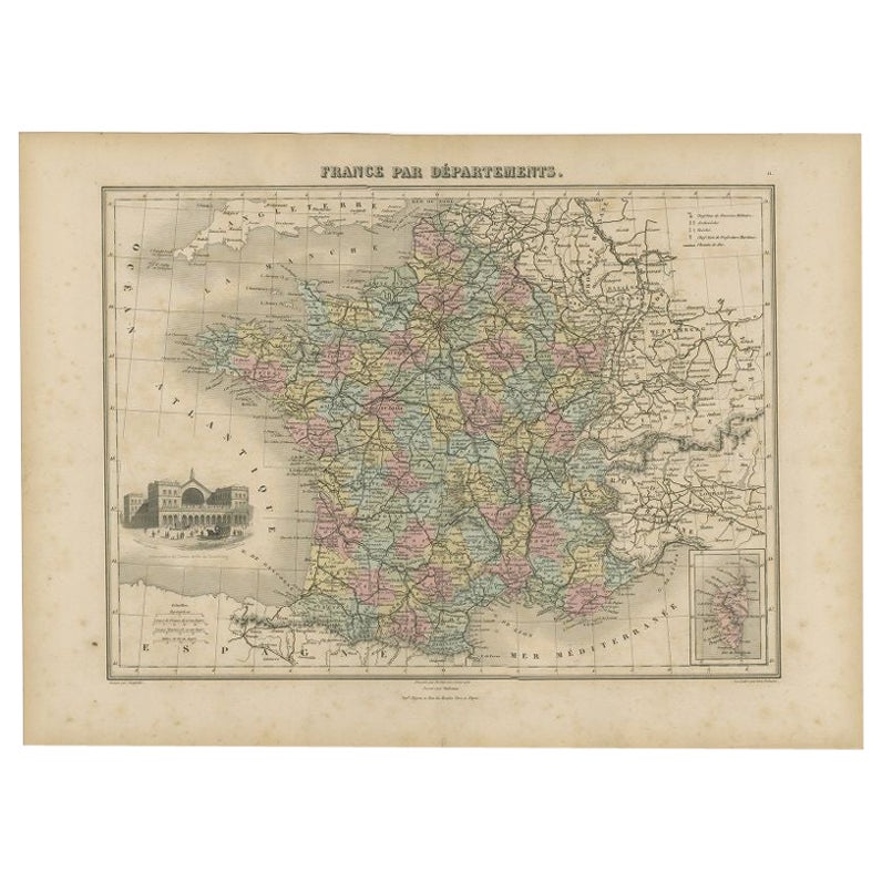
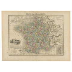
- Antique Map of the Departments of France by Migeon, 1880By J. MigeonLocated in Langweer, NLAntique map titled 'France par Départements'. Old map of France with a decorative vignette of Strasbourg and an inset map of Corsica. This map originate...Category
Antique 19th Century Maps
MaterialsPaper
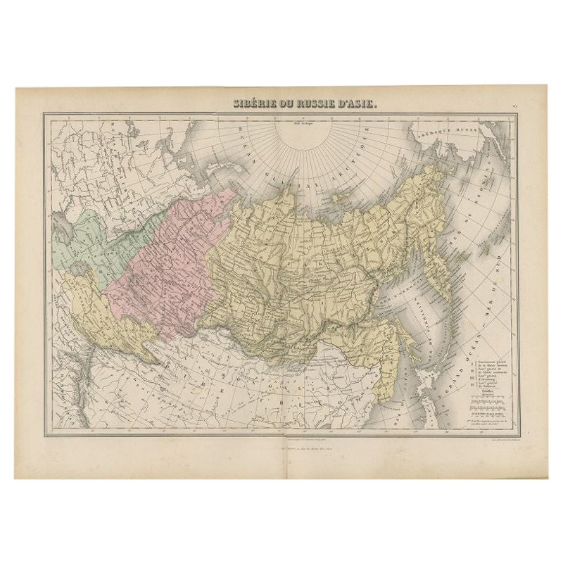
- Antique Map of Russia and Siberia by Migeon, 1880Located in Langweer, NLAntique map titled 'Sibérie ou Russie d'Asie'. Migeon's map covers the Russian empire in Asia from european Russia and the Ural Mountains to the Bering Strait and from the Arctic Cir...Category
Antique 19th Century Maps
MaterialsPaper


You May Also Like
- 1854 Map of Massachusetts, Connecticut and Rhode Island, Antique Wall MapLocated in Colorado Springs, COThis striking wall map was published in 1854 by Ensign, Bridgman & Fanning and has both full original hand-coloring and original hardware. This impression is both informative and highly decorative. The states are divided into counties, outlined in red, green, and black, and subdivided into towns. Roads, canals, and railroad lines are prominently depicted, although they are not all labeled. The mapmakers also marked lighthouses, banks, churches, and prominent buildings, with a key at right. The map is an informative and comprehensive overview of the infrastructural development of New England prior to the Civil War. Physical geographies depicted include elevation, conveyed with hachure marks, rivers and lakes. The impression features an inset map of Boston...Category
Antique 19th Century American Maps
MaterialsPaper
- Hand-Colored 18th Century Homann Map of Denmark and Islands in the Baltic SeaBy Johann Baptist HomannLocated in Alamo, CAAn 18th century copper plate hand-colored map entitled "Insulae Danicae in Mari Balthico Sitae utpote Zeelandia, Fionia, Langelandia, Lalandia, Falstria, Fembria Mona" created by Joh...Category
Antique Early 18th Century German Maps
MaterialsPaper
- Original Antique Map of Cyprus. Circa 1880Located in St Annes, LancashireGreat map of Cyprus Drawn and Engraved by R.Walker Published W.Mackenzie, London Original colour Unframed.Category
Antique 1880s English Maps
MaterialsPaper
- Large Original Antique Map of The Environs of Dublin, Ireland, circa 1880Located in St Annes, LancashireGreat map of The Environs of Dublin Published circa 1880 Unframed Free shipping.Category
Antique 1880s Scottish Maps
MaterialsPaper
- Large Original Antique Map of the Environs of Cork, Ireland, circa 1880Located in St Annes, LancashireGreat map of The Environs of Cork Published circa 1880 Unframed Free shipping.Category
Antique 1880s Scottish Maps
MaterialsPaper
- Large Original Vintage Map of Iceland, circa 1920Located in St Annes, LancashireGreat map of Iceland Original color. Good condition Published by Alexander Gross Unframed.Category
Vintage 1920s English Victorian Maps
MaterialsPaper


Recently Viewed
View AllMore Ways To Browse
The Denmark Collection
French Antique Island
Danish Antique And Modern
Antique Map Book
Antique Maps Book
Castle Antiques Design
Castle Antiques And Design
Book Of Antique Maps
Old Map Paris
Old Map Of Paris
Denmark Maps
Denmark Map
Antique Map Denmark
Migeon Migeon
Migeon And Migeon
Iceland Antique
Icelandic Antique
Faroe Islands