Items Similar to Antique Map of the East Indies by Rossi, 1683


Want more images or videos?
Request additional images or videos from the seller
1 of 5
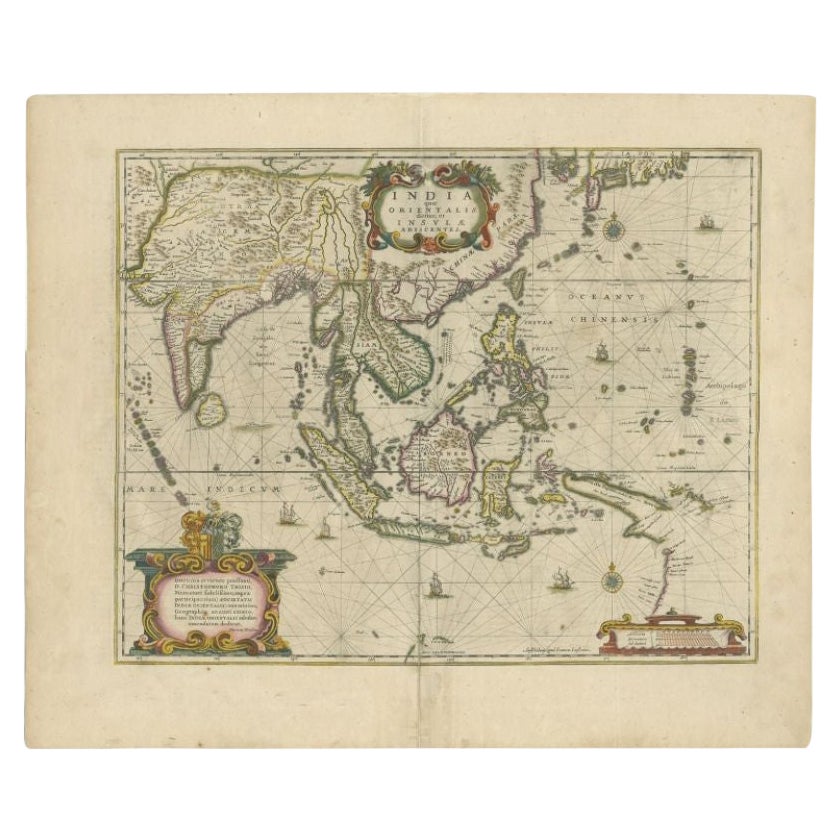
Antique Map of the East Indies by Rossi, 1683
About the Item
Antique map titled 'Isole Dell'India cioe le Molucche la Filippine e della Sonda Parte de Paesi di nuova scoperta e l'Isole de Ladri ne Mare del Zud (..)'. Decorative map of Southeast Asia, northern Australia and the islands of Melanesia. Depicting Malaya (Penisola di Malacca), Sumatra, Java, Celebes, Nova Guinea, and Nuova Olanda (Australia).
Artists and Engravers: Giacomo Giovanni Rossi (1627-1691) was an Italian engraver and printer. He worked in Rome, the heir to an important printing business founded by his father, Giuseppe De Rossi (1570-1639). Giuseppe began the press in 1633 and Giovanni and his brother, Giandomenico (1619-1653) took it over upon his death. The brothers expanded the business and by the mid-seventeenth century it was the best-known printing house in Rome. For his maps, Giovanni worked with Giacomo Cantelli da Vignola.
Condition: Fair, age-related toning. Some soiling, repair on folding line and right part of the map including the top right corner. Blank verso, please study image carefully.
Date: 1683
Overall size: 59.5 x 47 cm.
Image size: 58 x 44.5 cm.
We sell original antique maps to collectors, historians, educators and interior decorators all over the world. Our collection includes a wide range of authentic antique maps from the 16th to the 20th centuries. Buying and collecting antique maps is a tradition that goes back hundreds of years. Antique maps have proved a richly rewarding investment over the past decade, thanks to a growing appreciation of their unique historical appeal. Today the decorative qualities of antique maps are widely recognized by interior designers who appreciate their beauty and design flexibility. Depending on the individual map, presentation, and context, a rare or antique map can be modern, traditional, abstract, figurative, serious or whimsical. We offer a wide range of authentic antique maps for any budget.
- Dimensions:Height: 13.19 in (33.5 cm)Width: 18.51 in (47 cm)Depth: 0 in (0.01 mm)
- Materials and Techniques:
- Period:
- Date of Manufacture:1683
- Condition:Condition: Fair, age-related toning. Some soiling, repair on folding line and right part of the map including the top right corner. Blank verso, please study image carefully.
- Seller Location:Langweer, NL
- Reference Number:
About the Seller
5.0
Platinum Seller
These expertly vetted sellers are 1stDibs' most experienced sellers and are rated highest by our customers.
Established in 2009
1stDibs seller since 2017
1,929 sales on 1stDibs
Typical response time: <1 hour
- ShippingRetrieving quote...Ships From: Langweer, Netherlands
- Return PolicyA return for this item may be initiated within 14 days of delivery.
More From This SellerView All
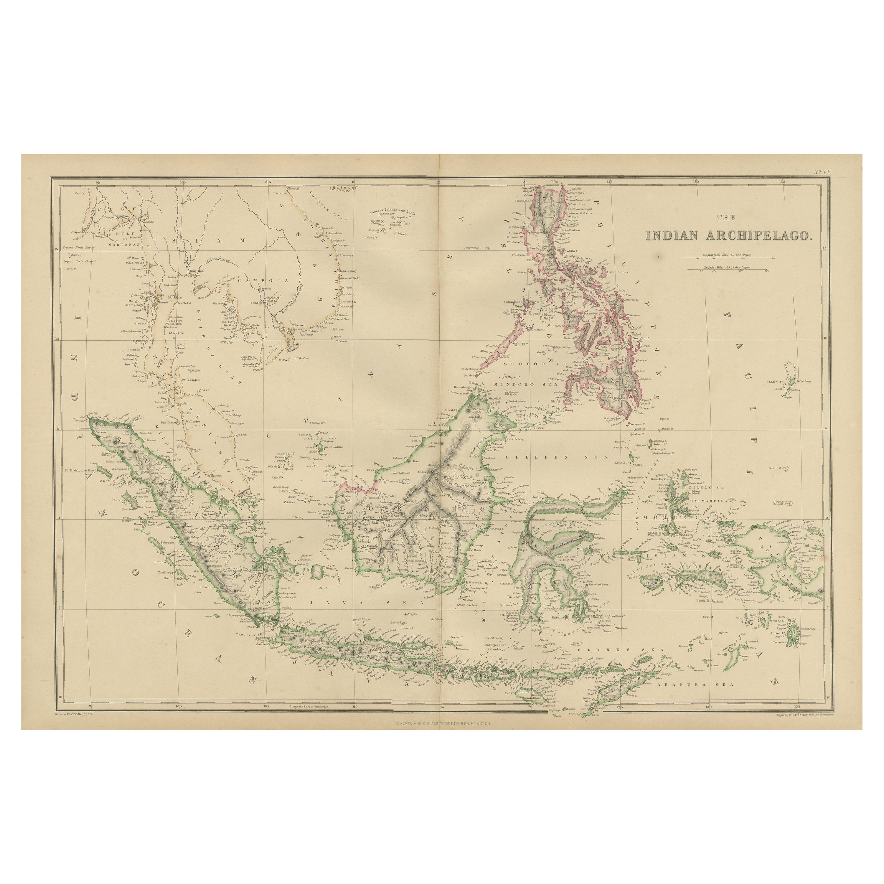
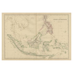
- Antique Map of the East Indies by W. G. Blackie, 1859Located in Langweer, NLAntique map titled 'The Indian Archipelago'. Original antique map of the East Indies. This map originates from ‘The Imperial Atlas of Modern Geography’. Published by W. G. Blackie, 1...Category
Antique Mid-19th Century Maps
MaterialsPaper
- Antique Map of the East Indies by A & C. Black, 1870Located in Langweer, NLAntique map titled 'Indian Archipelago and Further India including Burmah, Siam, Anam &c'. Original antique map of Indian Archipelago and Further India. This map originates from ‘Bla...Category
Antique Late 19th Century Maps
MaterialsPaper
- Antique Map of the East Indies by Wyld '1845'Located in Langweer, NLAntique map titled 'Archipelago of the Indian Ocean'. Original antique map of the East Indies. This map originates from 'An Atlas of the World, Comprehending Separate Maps of its Var...Category
Antique Mid-19th Century Maps
MaterialsPaper
- Antique Map of the East Indies by Levasseur, '1875'Located in Langweer, NLAntique map titled 'Carte de la Malaisie'. Large map of the East Indies. This map originates from 'Atlas de Géographie Moderne Physique et Politique' by A. Levasseur. Published 1875.Category
Antique Late 19th Century Maps
MaterialsPaper
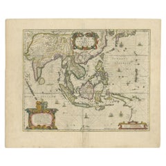
- Antique Map of the East Indies by Janssonius, c.1644By Johannes JanssoniusLocated in Langweer, NLAntique map titled 'India quae Orientalis dicitur, et Insulae adiacentes'. Old map of the East Indies and Southeast Asia showing the area between India in the West and parts of Japan...Category
Antique 17th Century Maps
MaterialsPaper
- Antique Map of the East Indies by Bonne '1776'Located in Langweer, NLAntique map titled 'Indes IVe Feuille'. Very decorative original antique map of the East Indies. Covbers from the Gulf of Siam (Gulf of Thailand) and Malacca (Malaysia) eastward to i...Category
Antique Late 18th Century Maps
MaterialsPaper


You May Also Like
- Original Antique Map of South East Asia by Becker, circa 1840Located in St Annes, LancashireGreat map of South East Asia Steel engraving with original color outline Engraved by Becker Published by Virtue, circa 1840. Unframed.Category
Antique 1840s English Other Maps
MaterialsPaper
- Original Antique Map of South East Asia by Thomas Clerk, 1817Located in St Annes, LancashireGreat map of South East Asia Copper-plate engraving Drawn and engraved by Thomas Clerk, Edinburgh. Published by Mackenzie And Dent, 1817 Unframed.Category
Antique 1810s English Maps
MaterialsPaper
- Original Antique Map of South East Asia, Arrowsmith, 1820Located in St Annes, LancashireGreat map of South East Asia Drawn under the direction of Arrowsmith Copper-plate engraving Published by Longman, Hurst, Rees, Orme and Brown, 1820 Unframed.Category
Antique 1820s English Maps
MaterialsPaper
- Original Antique English County Map, East Yorkshire, J & C Walker, 1851Located in St Annes, LancashireGreat map of The East Riding of Yorkshire Original colour By J & C Walker Published by Longman, Rees, Orme, Brown & Co. 1851 Unframed.Category
Antique 1850s English Other Maps
MaterialsPaper
- Original Antique Map of The World by Thomas Clerk, 1817Located in St Annes, LancashireGreat map of The Eastern and Western Hemispheres On 2 sheets Copper-plate engraving Drawn and engraved by Thomas Clerk, Edinburgh. Published by Mackenzie And Dent, 1817 ...Category
Antique 1810s English Maps
MaterialsPaper
- Original Antique Map of The Netherlands, Engraved by Barlow, Dated 1807Located in St Annes, LancashireGreat map of Netherlands Copper-plate engraving by Barlow Published by Brightly & Kinnersly, Bungay, Suffolk. Dated 1807 Unframed.Category
Antique Early 1800s English Maps
MaterialsPaper


Recently Viewed
View AllMore Ways To Browse
East Indies Furniture
East Indies
Map Of Rome
Map Rome
Rome Maps
Antique Southeast Asia
Southeast Asian Antiques
Antique Maps Australia
Antique Map Australia
Australia Antique Map
Antique Australia Map
Antique Australian Map
Antique Maps Of Australia
Antique Map Of Australia
Antique Australian Maps
East Java
East India Map
Java Map