Items Similar to Antique Map of Eastern Africa, Engraved by a German Missionary, 1858


Want more images or videos?
Request additional images or videos from the seller
1 of 5
Antique Map of Eastern Africa, Engraved by a German Missionary, 1858
About the Item
Original antique map of Eastern Africa. This map originates from 'Reisen in Ost-Afrika, ausgeführt in dem Jahren 1837-55' by J.L. Krapf. Published 1858.
Artists and Engravers: Johann Ludwig Krapf (11 January 1810 – 26 November 1881) was a German missionary in East Africa, as well as an explorer, linguist, and traveler.
Condition: Fair/good, general age-related toning. Original folding lines. SHows some wear/small defects and creasing. Blank verso. Please study image carefully.
Date: 1858
Overall size: 31 x 51 cm.
Image size: 30 x 49 cm.
- Dimensions:Height: 20.08 in (51 cm)Width: 12.21 in (31 cm)Depth: 0 in (0.01 mm)
- Materials and Techniques:
- Period:
- Date of Manufacture:1858
- Condition:
- Seller Location:Langweer, NL
- Reference Number:
About the Seller
5.0
Platinum Seller
These expertly vetted sellers are 1stDibs' most experienced sellers and are rated highest by our customers.
Established in 2009
1stDibs seller since 2017
1,933 sales on 1stDibs
Typical response time: <1 hour
- ShippingRetrieving quote...Ships From: Langweer, Netherlands
- Return PolicyA return for this item may be initiated within 14 days of delivery.
More From This SellerView All
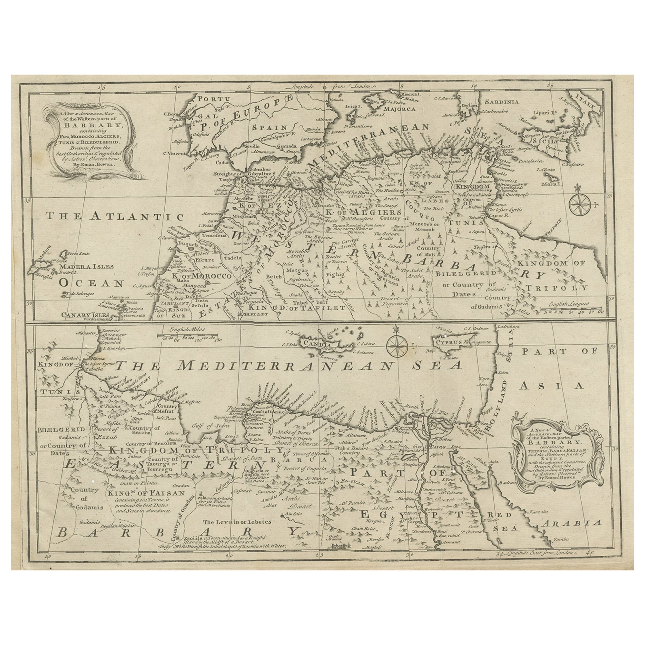
- Antique Map of Western and Eastern Barbary in Africa, c.1744Located in Langweer, NLAntique map titled 'A New & Accurate Map of the Western Parts of Barbary' and 'A New & Accurate Map of the Eastern Parts of Barbary'. Decorative maps of North Africa and the Southern...Category
Antique 18th Century Maps
MaterialsPaper
- Antique Map of Eastern Polynesia, 1849Located in Langweer, NLAntique map titled 'Ost-Polynesien'. Interesting variant issue, with large detailed insets top right of Hawaii volcanos near Kilauea. Insets lower right of Honolulu harbour, island o...Category
Antique Mid-19th Century Maps
MaterialsPaper
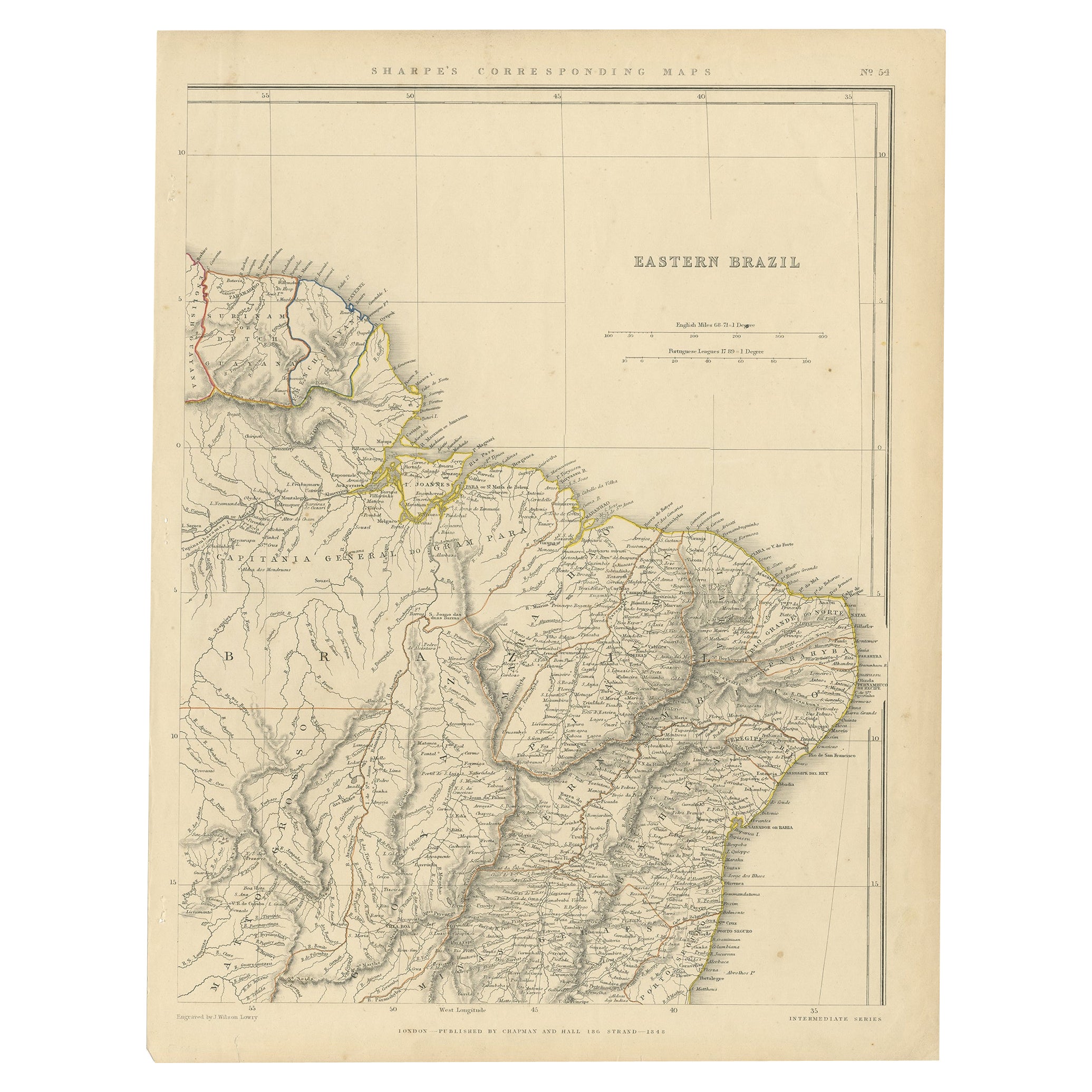
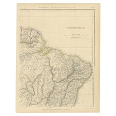
- Antique Map of Eastern Brazil, 1849Located in Langweer, NLAntique map titled 'Eastern Brazil'. Old map of Eastern Brazil. This map originates from 'Sharpe's Corresponding Atlas (..)' by J. Sharpe. Artists and Engravers: Published by Chap...Category
Antique 19th Century Maps
MaterialsPaper
- Antique Map of Eastern Persia, 1852Located in Langweer, NLAntique map titled 'Eastern Persia'. Original map of Eastern Persia. This map originates from 'Lowry's Table Atlas constructed and engraved from the most recent Authorities' by J.W. ...Category
Antique Mid-19th Century Maps
MaterialsPaper
- Antique Map of Eastern Siberia by Bellin '1768'Located in Langweer, NLAntique map titled 'Suite de la Carte de la Siberie et le Pays de Kamtchatka'. Original antique map of the eastern portion of Siberia, centered on eastern Russia and the Mer d'Ochozk (Sea of Okhotsk) showing the Kamchatka Peninsula and I. de Beringe and I. Sagalin. The map shows the tracks of Russian ships...Category
Antique Mid-18th Century Maps
MaterialsPaper
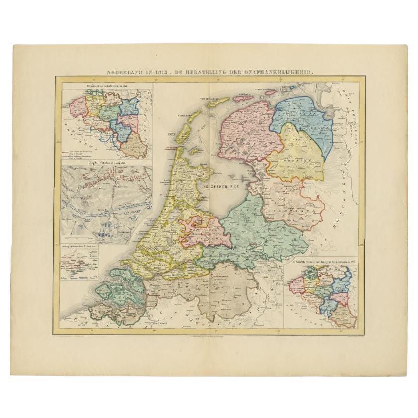
- Antique Map of the Netherlands in 1814 by Mees, 1858Located in Langweer, NLAntique map titled 'Noord-Nederland in 1814. De herstelling der onafhankelijkheid'. Map of the Netherlands in 1814. This map originates from 'Historische Atlas van Noord-Nederland'. ...Category
Antique 19th Century Maps
MaterialsPaper


You May Also Like
- Original Antique Map of Sweden, Engraved by Barlow, 1806Located in St Annes, LancashireGreat map of Sweden Copper-plate engraving by Barlow Published by Brightly & Kinnersly, Bungay, Suffolk. 1806 Unframed.Category
Antique Early 1800s English Maps
MaterialsPaper
- English Engraved Hand Colored Map of the North Eastern United States, circa 1817Located in Hollywood, SCEnglish copper engraved hand colored map of the North Eastern United States matted under glass in a gilt frame, Early 19th Century. Drawn and Engraved for Thomson's New General Atlas...Category
Antique 1810s English George III Maps
MaterialsPaper, Paint, Giltwood, Glass
- Original Antique Map of Switzerland, Engraved By Barlow, Dated 1807Located in St Annes, LancashireGreat map of Switzerland Copper-plate engraving by Barlow Published by Brightly & Kinnersly, Bungay, Suffolk. Dated 1807 Unframed.Category
Antique Early 1800s English Maps
MaterialsPaper
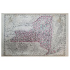
- 1858 Colton's Map of New York, Ric.B011Located in Norton, MAAn 1858 Colton's map of New York Ric.b011 Colton’s New York, 1858 - A large original color engraved and very detailed map of the state of New York,...Category
Antique 19th Century Unknown Maps
MaterialsPaper
- Original Antique Map of Spain and Portugal, Engraved By Barlow, 1806Located in St Annes, LancashireGreat map of Spain And Portugal Copper-plate engraving by Barlow Published by Brightly & Kinnersly, Bungay, Suffolk. 1806 Unframed.Category
Antique Early 1800s English Maps
MaterialsPaper
- Original Antique Map of The Netherlands, Engraved by Barlow, Dated 1807Located in St Annes, LancashireGreat map of Netherlands Copper-plate engraving by Barlow Published by Brightly & Kinnersly, Bungay, Suffolk. Dated 1807 Unframed.Category
Antique Early 1800s English Maps
MaterialsPaper


Recently Viewed
View AllMore Ways To Browse
Date Engraved
Eastern Antiques
19th Century German Collectibles
19th Century Africa Collectibles
Eastern Germany
Antique Maps Africa
Antique Map Africa
Antique Africa Map
Antique African Map
Africa Antique Map
Antique Africa Maps
Antique African Maps
Africa Map Antique
Antique Map Of Africa
Antique Maps Of Africa
J Blank
19th Century Map Of Africa
East Africa Map