Items Similar to Antique Map of the Famous French Wine Area of Correze, 1854
Want more images or videos?
Request additional images or videos from the seller
1 of 5
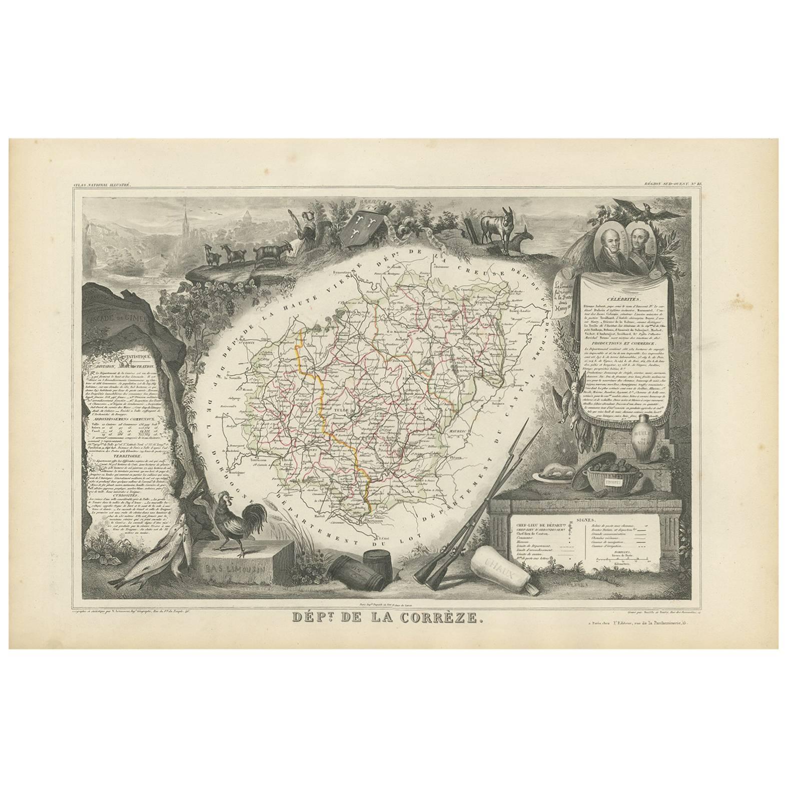
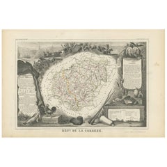
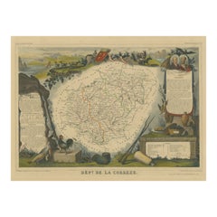
Antique Map of the Famous French Wine Area of Correze, 1854
About the Item
Antique map titled 'Dépt. da la Corrèze'. Map of the French department of Correze, France. This area of France is known for its production of straw wine, a sweet red or white wine. The whole is surrounded by elaborate decorative engravings designed to illustrate both the natural beauty and trade richness of the land. There is a short textual history of the regions depicted on both the left and right sides of the map. This map originates from ‘Atlas National de la France Illustré’ by V. Levasseur.
Arists and Engravers: Published by A. Combette, Paris, 1854.
Condition: Good, general age-related toning. Few small tears, please study image carefully.
Date: 1854
Overall size: 53 x 36 cm.
Image size: 42.5 x 29.5 cm.
We sell original antique maps to collectors, historians, educators and interior decorators all over the world. Our collection includes a wide range of authentic antique maps from the 16th to the 20th centuries. Buying and collecting antique maps is a tradition that goes back hundreds of years. Antique maps have proved a richly rewarding investment over the past decade, thanks to a growing appreciation of their unique historical appeal. Today the decorative qualities of antique maps are widely recognized by interior designers who appreciate their beauty and design flexibility. Depending on the individual map, presentation, and context, a rare or antique map can be modern, traditional, abstract, figurative, serious or whimsical. We offer a wide range of authentic antique maps for any budget.
- Dimensions:Height: 14.18 in (36 cm)Width: 20.87 in (53 cm)Depth: 0 in (0.01 mm)
- Materials and Techniques:
- Period:
- Date of Manufacture:1854
- Condition:
- Seller Location:Langweer, NL
- Reference Number:
About the Seller
5.0
Platinum Seller
These expertly vetted sellers are 1stDibs' most experienced sellers and are rated highest by our customers.
Established in 2009
1stDibs seller since 2017
1,919 sales on 1stDibs
Typical response time: <1 hour
- ShippingRetrieving quote...Ships From: Langweer, Netherlands
- Return PolicyA return for this item may be initiated within 14 days of delivery.
More From This SellerView All
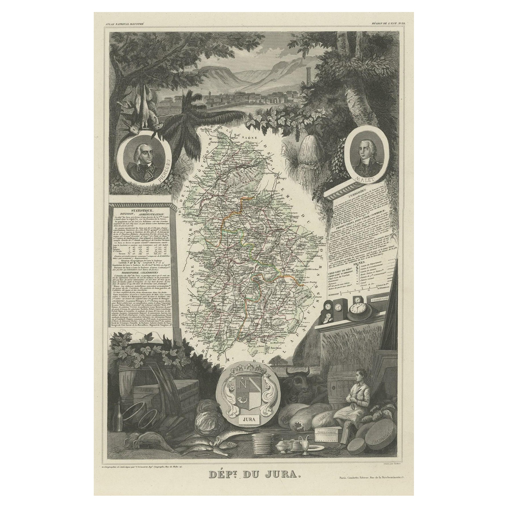
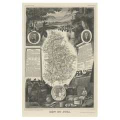
- Antique Map of Jura, a Famous Wine Area in France, 1854Located in Langweer, NLAntique map titled 'Dépt. du Jura'. Map of the French department Jura, France. Jura is a department in the Bourgogne-Franche-Comté region in Eastern France. Named after the Jura Mo...Category
Antique 19th Century Maps
MaterialsPaper
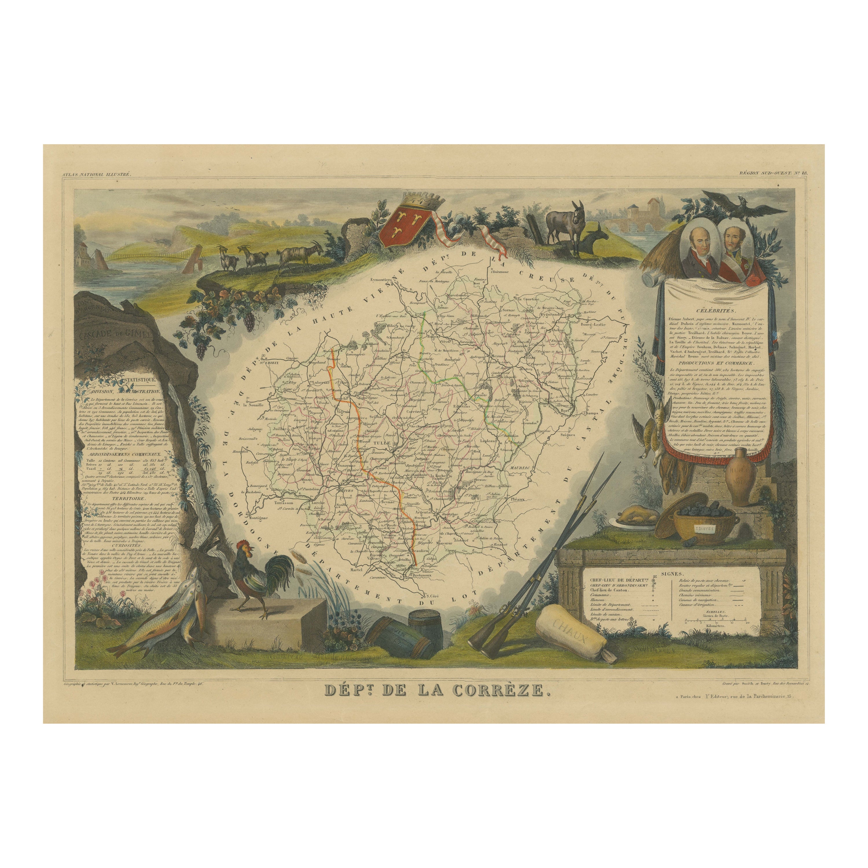
- Antique Map of Corrèze ‘France’ by V. Levasseur, 1854By Victor LevasseurLocated in Langweer, NLAntique map titled 'Dépt. da la Corrèze'. Map of the French department of Correze, France. This area of France is known for its production of Straw Wine, a sweet red or white wine. T...Category
Antique Mid-19th Century Maps
MaterialsPaper
- Hand Colored Antique Map of the Department of Correze, FranceBy Victor LevasseurLocated in Langweer, NLAntique map titled 'Dépt. de la Corrèze'. Map of the French department of Correze, France. This area of France is known for its production of Straw Wine, a sweet red or white wine. T...Category
Antique Mid-19th Century Maps
MaterialsPaper
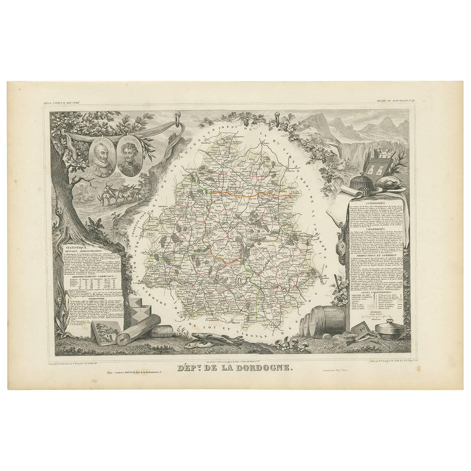
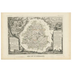
- Antique Map of the Dordogne ‘France’ by V. Levasseur, 1854Located in Langweer, NLAntique map titled 'Dépt. de la Dordogne'. Map of the French department of Dordogne, France. This area is best known for its production of Monbazillac, a sweet white wine, and Cabéco...Category
Antique Mid-19th Century Maps
MaterialsPaper
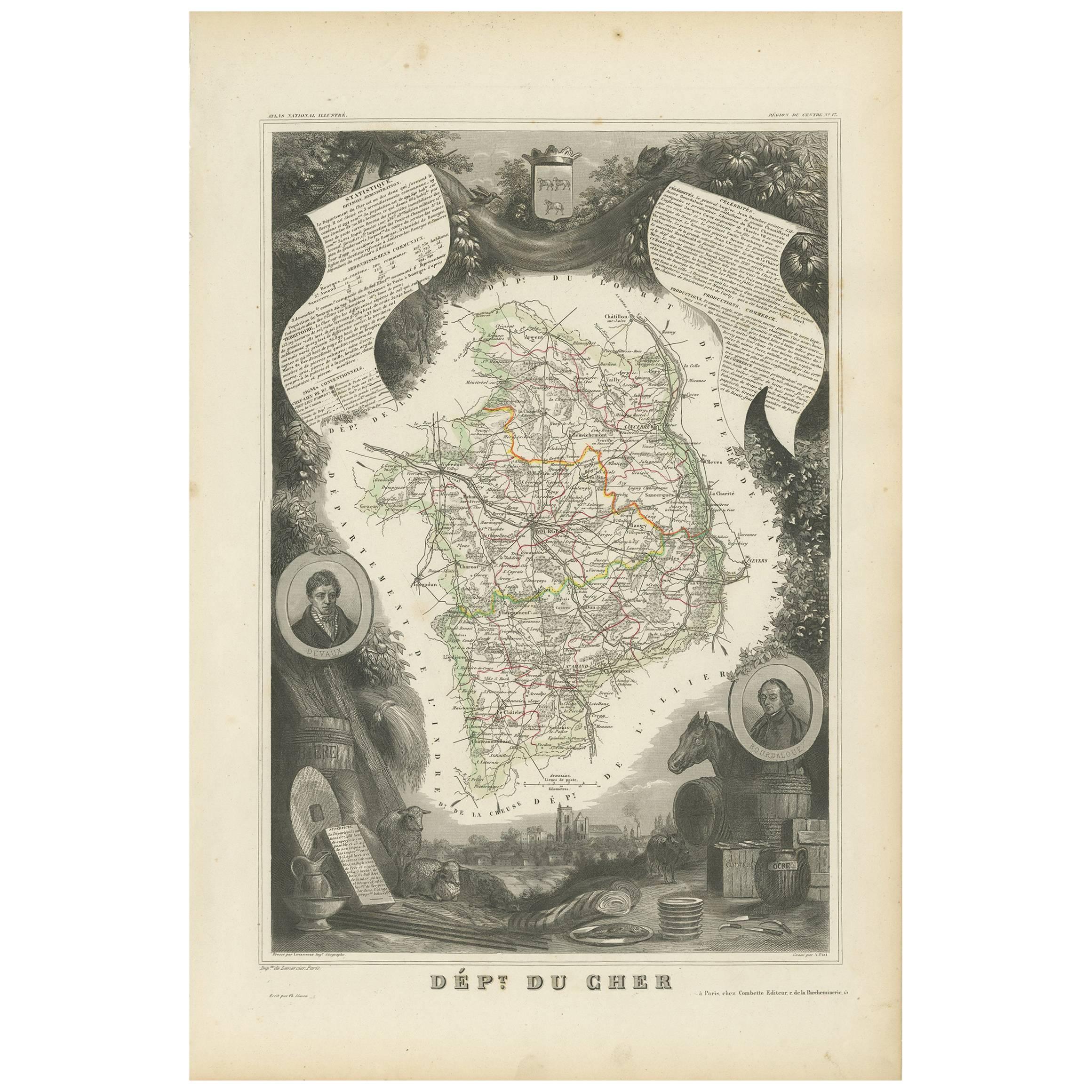
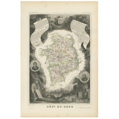
- Antique Map of Cher in France, 1854By Victor LevasseurLocated in Langweer, NLAntique map titled 'Dépt. des Bses. Pyrénées'. Map of the French department of Basses Pyrenees, France. This department includes the Jurancon wine region, famous for its production d...Category
Antique Mid-19th Century Maps
MaterialsPaper
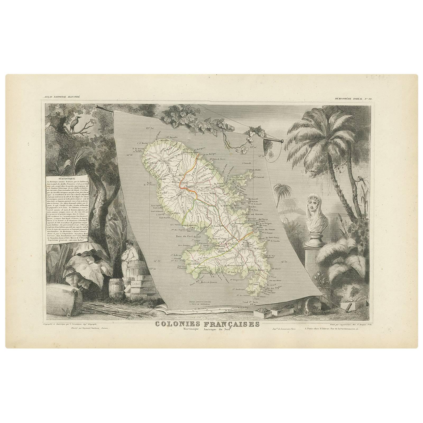
- Antique Map of the French Colony Martinique by V. Levasseur, 1854By Victor LevasseurLocated in Langweer, NLAntique map titled 'Colonies Françaises. Martinique, Amérique du Sud'. This map originates from ‘Atlas National de la France Illustré’. Published by A. Combette, Paris, 1854.Category
Antique Mid-19th Century Maps
MaterialsPaper

You May Also Like
- 1854 Map of Massachusetts, Connecticut and Rhode Island, Antique Wall MapLocated in Colorado Springs, COThis striking wall map was published in 1854 by Ensign, Bridgman & Fanning and has both full original hand-coloring and original hardware. This impression is both informative and highly decorative. The states are divided into counties, outlined in red, green, and black, and subdivided into towns. Roads, canals, and railroad lines are prominently depicted, although they are not all labeled. The mapmakers also marked lighthouses, banks, churches, and prominent buildings, with a key at right. The map is an informative and comprehensive overview of the infrastructural development of New England prior to the Civil War. Physical geographies depicted include elevation, conveyed with hachure marks, rivers and lakes. The impression features an inset map of Boston...Category
Antique 19th Century American Maps
MaterialsPaper
- Gilt Framed Vintage Wine Regions of France MapLocated in Alton, GBFramed French wine region map 1973. The print has been removed to clean the glass, the frame has minor damage in places but nothing that detracts from ...Category
Vintage 1970s French Posters
MaterialsPaper
- 1861 Topographical Map of the District of Columbia, by Boschke, Antique MapLocated in Colorado Springs, COPresented is an original map of Albert Boschke's extremely sought-after "Topographical Map of the District of Columbia Surveyed in the Years 1856 ...Category
Antique 1860s American Historical Memorabilia
MaterialsPaper
- Original Antique Map of France, Arrowsmith, 1820Located in St Annes, LancashireGreat map of France Drawn under the direction of Arrowsmith. Copper-plate engraving. Published by Longman, Hurst, Rees, Orme and Brown, 1820 Unframed.Category
Antique 1820s English Maps
MaterialsPaper
- Midcentury English Portobello Famous Wines in the World on Display CaseLocated in Vigonza, Padua1960s midcentury English Portobello "Famous wines" in the world on display case Measures cm: H 34 W 108, D 9.Category
Mid-20th Century English Historical Memorabilia
MaterialsGlass, Wood
- 1812 United States Map, by Pierre Tardieu, Antique French Map Depicting the U.S.By Pierre François TardieuLocated in Colorado Springs, CO1812 "United States of Nth America -- Carte des Etats-Unis De L'Amerique Septentrionale" Two-Sheet Map by Tardieu This attractive map, published in Paris in 1812, is one of the most rare large format maps from the period. It features a view of the East Coast of the U.S. from Maryland to just below South Carolina. Additionally, Ellicott’s plan for the City of Washington D.C. is included at the top right and an illustration of Niagara Falls is shown at the bottom right with a description in both French and English. This extremely detailed map not only depicts the mountainous regions of the southeastern U.S., but also includes names of regions, rivers, and towns. Based on the first state of Arrowsmith’s 4-sheet map of the United States, this map is completely engraved by Tardieu in Paris and showcases high quality engravings. This detailed map of the recently independent United States includes one of the largest and earliest examples of the Ellicott plan of Washington DC. The artist, Pierre François Tardieu (PF Tardieu) was a very well-known map engraver, geographer, and illustrator. Awarded a bronze medal by King Louis-Phillipe for the accuracy and beauty of his map-making, Tardieu produced many fine works including maps of Louisiana...Category
Antique 1810s French Maps
MaterialsPaper


Recently Viewed
View AllMore Ways To Browse
Antique French Wine
Antique Map Of Paris
Antique Maps Of Paris
Wine Related
Rare Map France
Antique Maps Of Paris France
Antique Map Of Paris France
Wine Maps
Wine Map
Map Of France Wine
Wine Map France
French Wine Map
16th Wine
Antique Wine Maps
Antique Furniture Long Island
Antique London Maps
Antique London Map
Antique Map London