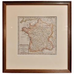
Antique Map of France by Vaugondy, circa 1750
View Similar Items


Want more images or videos?
Request additional images or videos from the seller
1 of 5
Antique Map of France by Vaugondy, circa 1750
About the Item
- Dimensions:Height: 11.03 in (28 cm)Width: 10.52 in (26.7 cm)Depth: 0.6 in (1.5 cm)
- Materials and Techniques:
- Period:
- Date of Manufacture:circa 1750
- Condition:General age-related toning, original folding lines. Frame included, lightly used. Please study images carefully.
- Seller Location:Langweer, NL
- Reference Number:Seller: BG-073741stDibs: LU3054321428132
About the Seller
5.0
Recognized Seller
These prestigious sellers are industry leaders and represent the highest echelon for item quality and design.
Gold Seller
Premium sellers maintaining a 4.3+ rating and 24-hour response times
Established in 2009
1stDibs seller since 2017
2,452 sales on 1stDibs
Authenticity Guarantee
In the unlikely event there’s an issue with an item’s authenticity, contact us within 1 year for a full refund. DetailsMoney-Back Guarantee
If your item is not as described, is damaged in transit, or does not arrive, contact us within 7 days for a full refund. Details24-Hour Cancellation
You have a 24-hour grace period in which to reconsider your purchase, with no questions asked.Vetted Professional Sellers
Our world-class sellers must adhere to strict standards for service and quality, maintaining the integrity of our listings.Price-Match Guarantee
If you find that a seller listed the same item for a lower price elsewhere, we’ll match it.Trusted Global Delivery
Our best-in-class carrier network provides specialized shipping options worldwide, including custom delivery.More From This Seller
View AllAntique Map of the Russian Empire in Europe by Vaugondy, 1750
Located in Langweer, NL
Antique map titled 'Partie Occidentale de l'Empire de Russie (..)'. Detailed map of the western part of Russia, extending south to the Caspian and east to Irkurkoy and Ilimskoy.
A...
Category
Antique 18th Century Maps
Materials
Paper

$316 Sale Price
20% Off
Antique Map of America by Vaugondy, 1778
Located in Langweer, NL
Antique map titled 'Amerique ou Indes Occidentales (..)'. Vaugondy's map of America, pre-dating information from any of the Cook Voyages. The NW Coast of Amer...
Category
Antique Late 18th Century Maps
Materials
Paper

$1,130 Sale Price
35% Off
Antique Map of Pomerania by Schenk, circa 1750
Located in Langweer, NL
The "Ducatus Pomeraniae" is a historical map depicting the Duchy of Pomerania, a region that straddles the modern border between northeastern Germany and Poland. Crafted with ornamen...
Category
Antique Mid-18th Century Maps
Materials
Paper

$465 Sale Price
20% Off
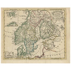
Antique Map of Scandinavia by T. Jefferys, circa 1750
Located in Langweer, NL
Antique map titled 'Sweden, Denmark, Norway & Finland'. An original mid-18th century copper engraved antique map of Scandinavia by Thomas Jefferys....
Category
Antique Mid-18th Century Maps
Materials
Paper
$176 Sale Price
20% Off
Antique Map of New England and Part of Canada by Vaugondy 'circa 1755'
Located in Langweer, NL
Antique map titled 'Partie de l'Amérique septent qui comprend la nouvelle France ou le Canada'. Decorative and highly detailed map of New England an...
Category
Antique Mid-18th Century Maps
Materials
Paper

$1,528 Sale Price
24% Off
Antique Map of the Indonesian and Philippine Archipelagos by R. de Vaugondy
Located in Langweer, NL
Striking and highly detailed map of the region from Sumatra and Malaca and Southern China to the Philipines, New Guinea and Northern Australia, centered on Borneo. Includes a large i...
Category
Antique Mid-18th Century Maps
Materials
Paper

$1,084 Sale Price
20% Off
You May Also Like
California, Alaska and Mexico: 18th Century Hand-Colored Map by de Vaugondy
By Didier Robert de Vaugondy
Located in Alamo, CA
This an 18th century hand-colored map of the western portions of North America entitled "Carte de la Californie et des Pays Nord-Ouest separés de l'Asie par le détroit d'Anian, extra...
Category
Antique 1770s French Maps
Materials
Paper

Original Antique Map of Spain and Portugal, circa 1790
Located in St Annes, Lancashire
Super map of Spain and Portugal
Copper plate engraving by A. Bell
Published, circa 1790.
Unframed.
Category
Antique 1790s English Other Maps
Materials
Paper

Antique Map of Italy by Andriveau-Goujon, 1843
By Andriveau-Goujon
Located in New York, NY
Antique Map of Italy by Andriveau-Goujon, 1843. Map of Italy in two parts by Andriveau-Goujon for the Library of Prince Carini at Palazzo Carini i...
Category
Antique 1840s French Maps
Materials
Linen, Paper

$3,350 / set
Antique Map of Principality of Monaco
By Antonio Vallardi Editore
Located in Alessandria, Piemonte
ST/619 - "Old Geographical Atlas of Italy - Topographic map of ex-Principality of Monaco" -
ediz Vallardi - Milano -
A somewhat special edition ---
Category
Antique Late 19th Century Italian Other Prints
Materials
Paper

Original Antique Map of Sweden, Engraved by Barlow, 1806
Located in St Annes, Lancashire
Great map of Sweden
Copper-plate engraving by Barlow
Published by Brightly & Kinnersly, Bungay, Suffolk. 1806
Unframed.
Category
Antique Early 1800s English Maps
Materials
Paper

Original Antique Map of Switzerland, Engraved By Barlow, Dated 1807
Located in St Annes, Lancashire
Great map of Switzerland
Copper-plate engraving by Barlow
Published by Brightly & Kinnersly, Bungay, Suffolk.
Dated 1807
Unframed.
Category
Antique Early 1800s English Maps
Materials
Paper

Recently Viewed
View AllMore Ways To Browse
Canadian Atlas Furniture
Ottoman Map
Antique Compass Made In France
Hindeloopen Furniture
Jamaican Antique Furniture
Sardinia Map
Map Sea Monsters
Missouri Map
Afghanistan Antique Map
Antique Florida Map
Nantucket Map
Antique Map Of Hawaii
Antique Maps Jerusalem
L Tardieu
Map Of Syria
Richard Wentworth
Antique Pennsylvania Map
Maps Balkans