Items Similar to Antique Map of the Gulf of Mexico and all the islands of the West Indies


Want more images or videos?
Request additional images or videos from the seller
1 of 6
Antique Map of the Gulf of Mexico and all the islands of the West Indies
About the Item
Antique map titled 'Carte du Golfe du Mexique'. This uncommon map depicts the Gulf of Mexico and all the islands of the West Indies. It also includes nice detail of the southern United States, Central America, and Northern South America. Place names, Indian tribes, rivers, lakes, bays, and more are shown. There is good topographical detail concentrated in Mexico, Central America, and the larger islands in the Caribbean. This map originates from La Harpe's 'Histoire Generale des Voyages'. Engraved by A. Tardieu, 1821.
- Dimensions:Height: 17.41 in (44.2 cm)Width: 23.63 in (60 cm)Depth: 0.02 in (0.5 mm)
- Materials and Techniques:
- Period:
- Date of Manufacture:1821
- Condition:Wear consistent with age and use. General age-related toning. Original folding line, blank verso. Shows some wear and foxing, blank verso. Please study image carefully.
- Seller Location:Langweer, NL
- Reference Number:Seller: BG-13189-41stDibs: LU3054331150682
About the Seller
5.0
Recognized Seller
These prestigious sellers are industry leaders and represent the highest echelon for item quality and design.
Gold Seller
Premium sellers maintaining a 4.3+ rating and 24-hour response times
Established in 2009
1stDibs seller since 2017
2,467 sales on 1stDibs
Typical response time: 1 hour
- ShippingRetrieving quote...Shipping from: Langweer, Netherlands
- Return Policy
Authenticity Guarantee
In the unlikely event there’s an issue with an item’s authenticity, contact us within 1 year for a full refund. DetailsMoney-Back Guarantee
If your item is not as described, is damaged in transit, or does not arrive, contact us within 7 days for a full refund. Details24-Hour Cancellation
You have a 24-hour grace period in which to reconsider your purchase, with no questions asked.Vetted Professional Sellers
Our world-class sellers must adhere to strict standards for service and quality, maintaining the integrity of our listings.Price-Match Guarantee
If you find that a seller listed the same item for a lower price elsewhere, we’ll match it.Trusted Global Delivery
Our best-in-class carrier network provides specialized shipping options worldwide, including custom delivery.More From This Seller
View AllAntique Map of Mexico, Central America and West Indies by A & C. Black, 1870
Located in Langweer, NL
Antique map titled 'Mexico, Central America and West Indies'. Original antique map of Mexico, Central America and West Indies with inset map of Panama railway. This map originates fr...
Category
Antique Late 19th Century Maps
Materials
Paper

$164 Sale Price
20% Off
Antique Map of North America Including the West Indies
Located in Langweer, NL
Original antique map titled 'Nord-America'. Old map of North America and the West Indies. Also showing British Overseas Territories and Hudson Bay.
This map originates from Stiel...
Category
Antique Mid-19th Century Maps
Materials
Paper

$545 Sale Price
20% Off
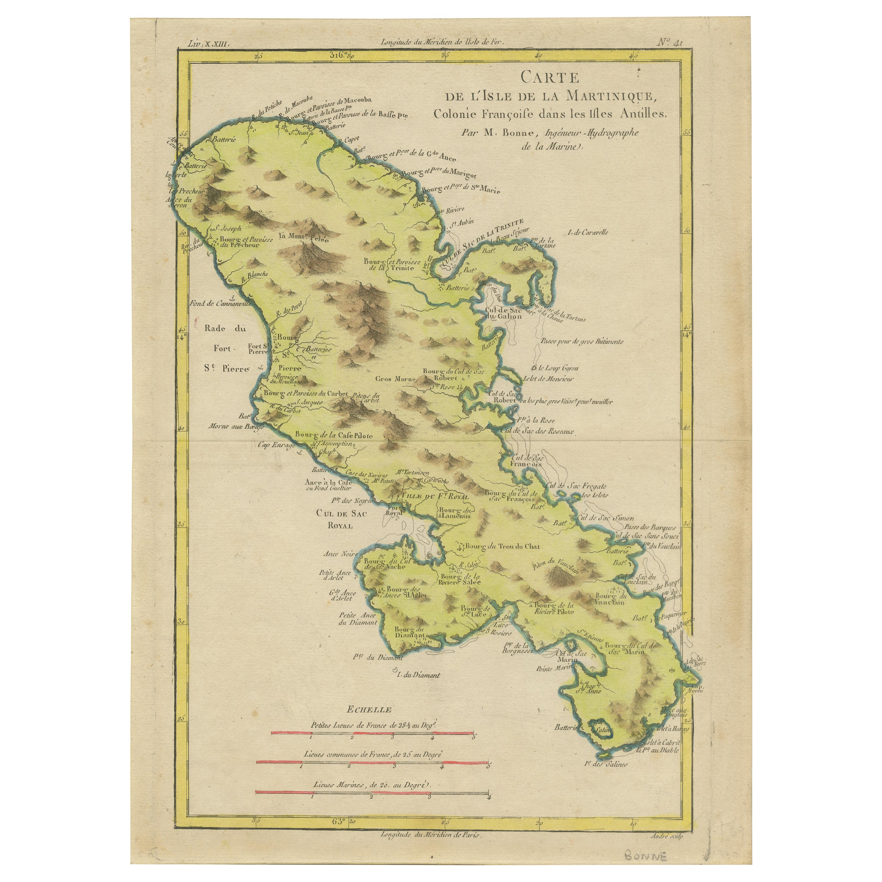
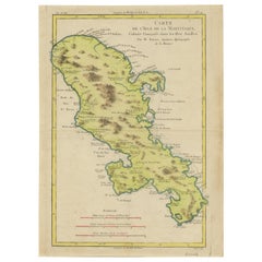
Original Antique Map of Martinique Island In The West Indies by Bonne, circa1780
Located in Langweer, NL
Antique map titled 'Carte de l'Isle de la Martinique Colonie Francoise dans les Isles Antilles'. Detailed map of the French Island of Martinique.
Many towns and harbours, anchor pl...
Category
Antique 18th Century Maps
Materials
Paper
$348 Sale Price
20% Off
Antique Map of the West Indies in Full Color, 1922
Located in Langweer, NL
Antique map titled 'The West Indies.' A map of the West Indies, the Carribean region. This includes the Greater Antilles (Jamaica, Haiti, Puerto Rico and Cuba) and the Lesser Antille...
Category
20th Century Maps
Materials
Paper
$131 Sale Price
20% Off
Antique Map of the West Indies and Central America by Lowry '1852'
Located in Langweer, NL
Antique map titled 'West Indies and Central America'. Original map of the West Indies and Central America. This map originates from 'Lowry's Table Atlas constructed and engraved from...
Category
Antique Mid-19th Century Maps
Materials
Paper

$94 Sale Price
20% Off
Antique Map of the West Indies and Central America by W. G. Blackie, 1859
Located in Langweer, NL
Antique map titled 'The West India Island & Central America'. Original antique map of the West Indies and Central America, with inset map of Jamaica. Th...
Category
Antique Mid-19th Century Maps
Materials
Paper

$235 Sale Price
20% Off
You May Also Like
Framed 1838 Mexico & Gulf of Mexico Map
Located in Stamford, CT
Framed 1838 Mexico & Gulf of Mexico map. Printed by Fisher, Son & Co. of London in 1838. As found framed condition. Map has not been examined outside of th...
Category
Antique 1830s English American Classical Maps
Materials
Glass, Wood, Paper

Cricket Print, England v. West Indies at the Oval, by Arthur Weaver
By Arthur Weaver
Located in Oxfordshire, GB
1990's Arthur Weaver Oval Cricket Ground Print, England v West Indies.
A colourful cricket lithograph signed by the artist, Arthur Weaver, of the 'Final Test' at The Oval Cricket Gr...
Category
1990s English Sporting Art Sports Equipment and Memorabilia
Materials
Paper

Hand-Colored 18th Century Homann Map of Denmark and Islands in the Baltic Sea
By Johann Baptist Homann
Located in Alamo, CA
An 18th century copper plate hand-colored map entitled "Insulae Danicae in Mari Balthico Sitae utpote Zeelandia, Fionia, Langelandia, Lalandia, Falstria, Fembria Mona" created by Joh...
Category
Antique Early 18th Century German Maps
Materials
Paper

Large Original Antique Map of The West Indies by Sidney Hall, 1847
Located in St Annes, Lancashire
Great map of The West Indies
Drawn and engraved by Sidney Hall
Steel engraving
Original colour outline
Published by A & C Black. 1847
Unframed
Free shipping.
Category
Antique 1840s Scottish Maps
Materials
Paper

Map of the Republic of Genoa
Located in New York, NY
Framed antique hand-coloured map of the Republic of Genoa including the duchies of Mantua, Modena, and Parma.
Europe, late 18th century.
Dimension: 25...
Category
Antique Late 18th Century European Maps

Antique Map of Principality of Monaco
By Antonio Vallardi Editore
Located in Alessandria, Piemonte
ST/619 - "Old Geographical Atlas of Italy - Topographic map of ex-Principality of Monaco" -
ediz Vallardi - Milano -
A somewhat special edition ---
Category
Antique Late 19th Century Italian Other Prints
Materials
Paper

Recently Viewed
View AllMore Ways To Browse
Ralph Lauren Woven Chair
Raymond Loewy Chair
Redwood Coffee Tables
Reed And Barton Creamer
Reed And Barton Teapot
Reed Barton Deco
Reed Barton Tray
Relish Dish
Retro Vintage Yellow Chair
Retro Yellow Formica Table
Rh Couch
Rh Sofas
Rhinoceros Porcelain
Rick Owens Dining Table
Rifle Bayonet
Ritts Acrylic
Robert Burns Antique
Robert Lansing