Items Similar to Antique Map of the Mongol Empire, 1767

Want more images or videos?
Request additional images or videos from the seller
1 of 5
Antique Map of the Mongol Empire, 1767
About the Item
Antique map titled 'The Moguls Empire divided into its principal governments'. Old map of India, Bangladesh, and parts of eastern China.
Artists and Engravers: Published in the Gentleman's Magazine.
Condition: Good, general age-related toning. Some wear, please study image carefully.
Date: 1767
Overall size: 22 x 28 cm.
Image size: 19.5 x 24 cm.
We sell original antique maps to collectors, historians, educators and interior decorators all over the world. Our collection includes a wide range of authentic antique maps from the 16th to the 20th centuries. Buying and collecting antique maps is a tradition that goes back hundreds of years. Antique maps have proved a richly rewarding investment over the past decade, thanks to a growing appreciation of their unique historical appeal. Today the decorative qualities of antique maps are widely recognized by interior designers who appreciate their beauty and design flexibility. Depending on the individual map, presentation, and context, a rare or antique map can be modern, traditional, abstract, figurative, serious or whimsical. We offer a wide range of authentic antique maps for any budget.
- Dimensions:Height: 11.03 in (28 cm)Width: 8.67 in (22 cm)Depth: 0 in (0.01 mm)
- Materials and Techniques:
- Period:
- Date of Manufacture:1767
- Condition:
- Seller Location:Langweer, NL
- Reference Number:
About the Seller
5.0
Platinum Seller
These expertly vetted sellers are 1stDibs' most experienced sellers and are rated highest by our customers.
Established in 2009
1stDibs seller since 2017
1,928 sales on 1stDibs
Typical response time: <1 hour
- ShippingRetrieving quote...Ships From: Langweer, Netherlands
- Return PolicyA return for this item may be initiated within 14 days of delivery.
More From This SellerView All
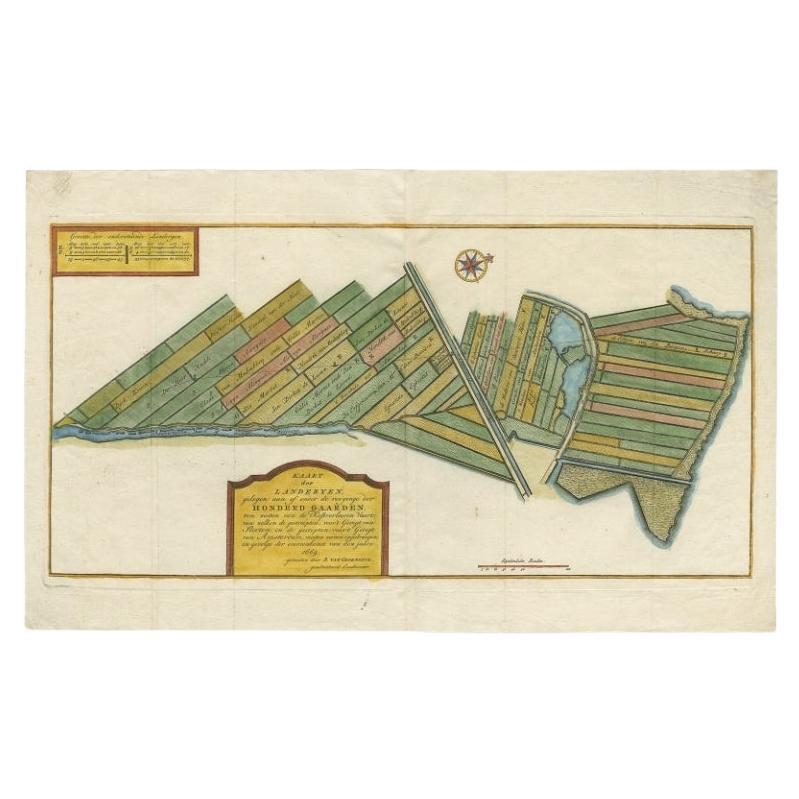
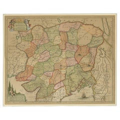
- Antique Map of Estates of The Year 1669 in Amsterdam, Published c.1767Located in Langweer, NLAntique map titled 'Kaart der Landerijen, gelegen aan of onder de rooyinge der honderd gaarden (..)'. Map showing estates in Amsterdam in 1669. Published by Yntema and Tieboel, 1767....Category
Antique 18th Century Maps
MaterialsPaper
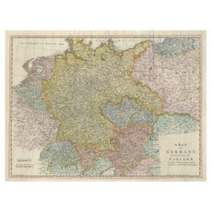
- Large Antique Map of the German EmpireLocated in Langweer, NLAntique map titled 'A Map of Germany (..)'. Large antique map of the German Empire, highly detailed. Engraved by T. Kitchin. Published J. Blair, cir...Category
Antique Late 18th Century Maps
MaterialsPaper
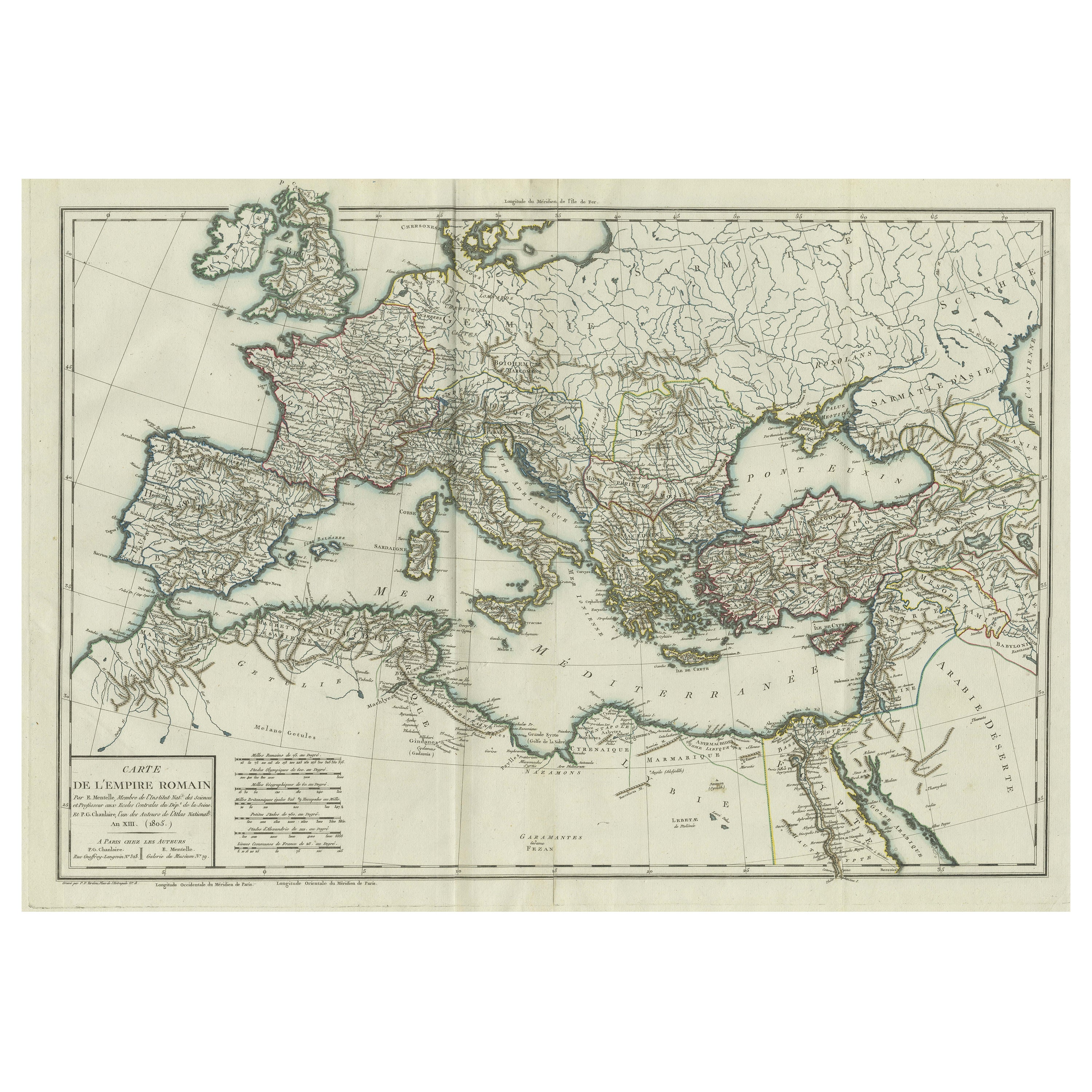
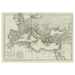
- Original Antique Map of the Roman EmpireLocated in Langweer, NLAntique map titled 'Carte de l'Empire Romain'. Original antique map of the Roman Empire, two sheets joined. Engraved by Pierre Francois Tardieu and published by Edme Mentelle, circa ...Category
Antique Late 18th Century Maps
MaterialsPaper
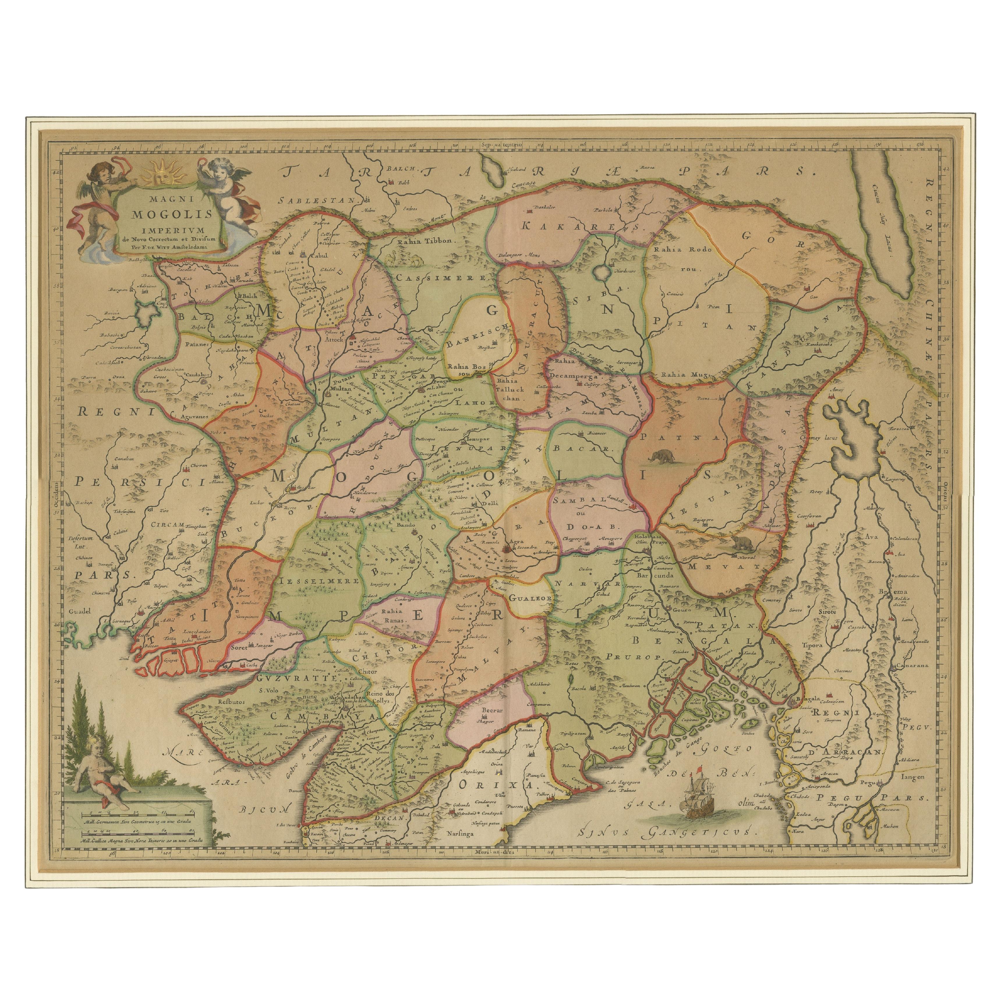
- Antique Map of the Empire of the Great MogulLocated in Langweer, NLAntique map titled 'Magni Mogolis Imperium'. This map depicts the Empire of the Great Mogul in northern India including the region from Iran to Burma. The Indus and Ganges Rivers are...Category
Antique Late 17th Century Maps
MaterialsPaper
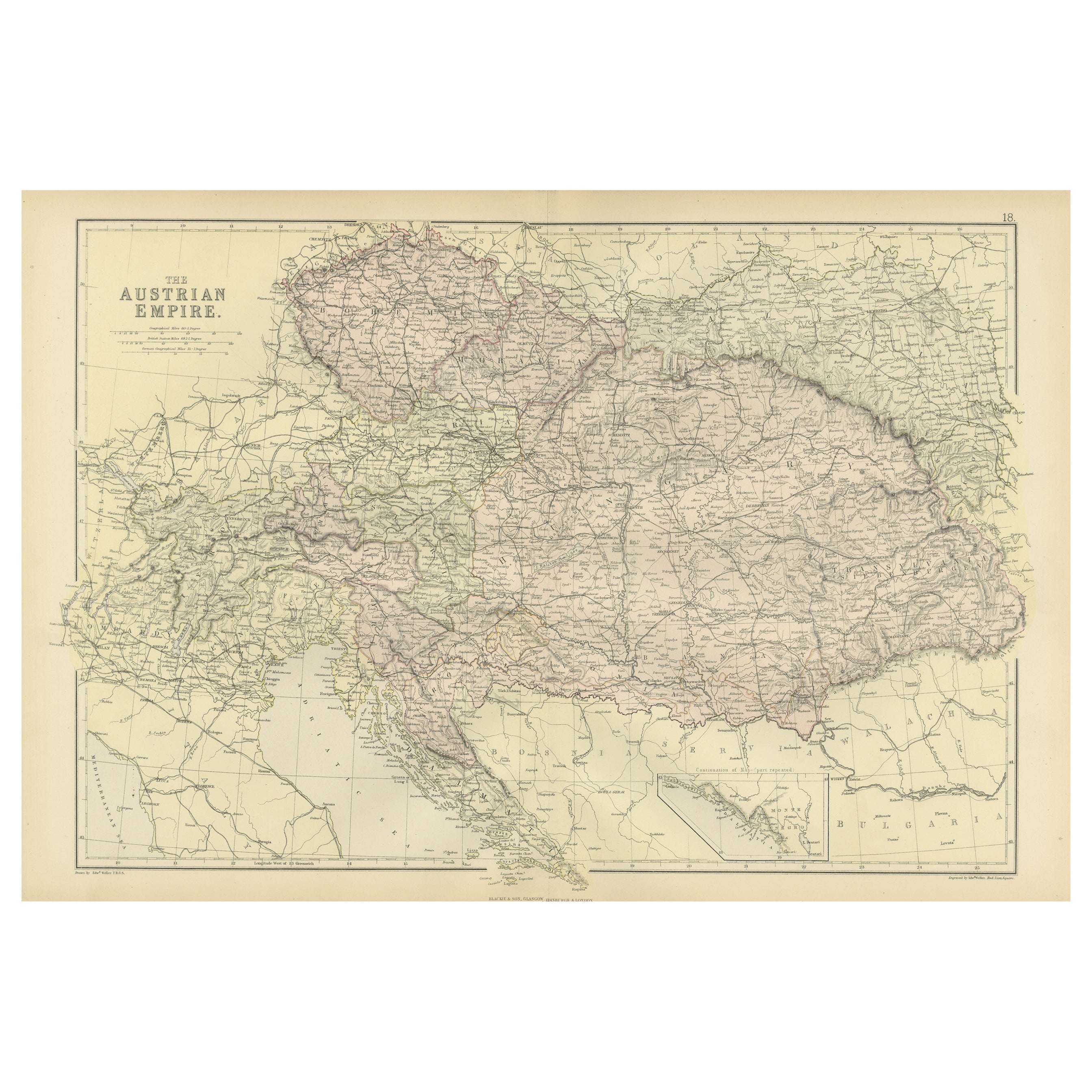
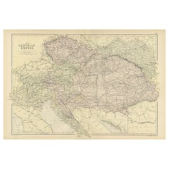
- Original Antique Map of The Austrian Empire, 1882Located in Langweer, NLStep into the past with an original Antique Map of The Austrian Empire from the esteemed 'Comprehensive Atlas and Geography of the World,' meticulously crafted in 1882. This intricat...Category
Antique 1880s Maps
MaterialsPaper
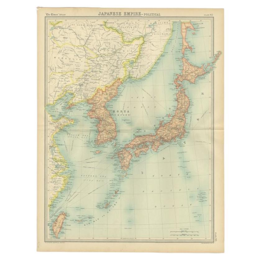
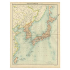
- Antique Political Map of the Japanese Empire, 1922Located in Langweer, NLAntique map of Japan titled 'Japanese Empire - Political Map'. Old map of Japan depicting Japan, Korea and surroundings. This map originates from 'The Ti...Category
20th Century Maps
MaterialsPaper

You May Also Like
- Super Rare Antique French Map of Chine and the Chinese Empire, 1780Located in Amsterdam, Noord HollandSuper Rare Antique French Map of Chine and the Chinese Empire, 1780 Very nice map of Asia. 1780 Made by Bonne. Additional information: Type: Map ...Category
Antique 18th Century European Maps
MaterialsPaper
- 1861 Topographical Map of the District of Columbia, by Boschke, Antique MapLocated in Colorado Springs, COPresented is an original map of Albert Boschke's extremely sought-after "Topographical Map of the District of Columbia Surveyed in the Years 1856 ...Category
Antique 1860s American Historical Memorabilia
MaterialsPaper
- Antique Carte de L'Inde Myanmar, Malaysia Vietnam Map of Asia the Chinese EmpireLocated in Amsterdam, Noord HollandAntique Carte de L'Inde Myanmar, Malaysia Vietnam Map of Asia the Chinese Empire Very nice map of Asia. Additional information: Type: Map Country of Man...Category
Antique 18th Century European Maps
MaterialsPaper
- 1814 Map of "Russian Empire" Ric.r032Located in Norton, MA1814 Map of "Russian Empire" Ric.r032 Russian Empire. Description: This is an 1814 John Thomson map of the Russian Empire. The map depicts the region from the Baltic Sea, Prussia, and Sweden to the Aleutian Islands and from the Arctic Ocean to the Yellow River. Highly detailed, myriad cities, towns, and villages are labeled throughout, including St. Petersburg, Moscow, Minsk, Kiev, and Kharkov. Rivers and mountain ranges are also identified, as are islands and numerous locations along the coastlines. It is important to note that the long-disputed sea between Korea and Japan is identified as the 'Sea of Japan. Historical Context: In 1815, Tsarist Russia emerged from the Napoleonic Wars economically insolvent and politically fearful of the Revolutionary fervor that had just swept through Europe. In order to shore up Russia's economic position, the Tsars began an aggressive series of expansions into the Caucuses and Central Asia that would vastly increase the landmass of the Russian Empire. Publication History Thomson maps are known for their stunning color, awe inspiring size, and magnificent detail. Thomson's work, including this map, represents some of the finest cartographic art...Category
Antique 19th Century Unknown Maps
MaterialsPaper
- Original Antique Map of the American State of Pennsylvania, 1889Located in St Annes, LancashireGreat map of Pennsylvania Drawn and Engraved by W. & A.K. Johnston Published By A & C Black, Edinburgh. Original colour Unframed. Repair to a minor tear on bottom edge.Category
Antique 1880s Scottish Victorian Maps
MaterialsPaper
- Original Antique Map of the American State of Washington, 1889Located in St Annes, LancashireGreat map of Washington Drawn and Engraved by W. & A.K. Johnston Published By A & C Black, Edinburgh. Original colour Unframed.Category
Antique 1880s Scottish Victorian Maps
MaterialsPaper


Recently Viewed
View AllMore Ways To Browse
For The Empire
Empire China
Chinese Hundred Antiques
Chinese Antique Map
Antique Chinese Divider
Antique Prints Of A Cross
Portuguese 16th
Pirate Furniture
Antique In Philippines
Victorian Book Ends
18th Century Maps America
Denmark Map
Pediment Metal
Map Hondius
Russian Antique Book
Latin Book
Map Of Egypt
Antique Furniture In Philippines