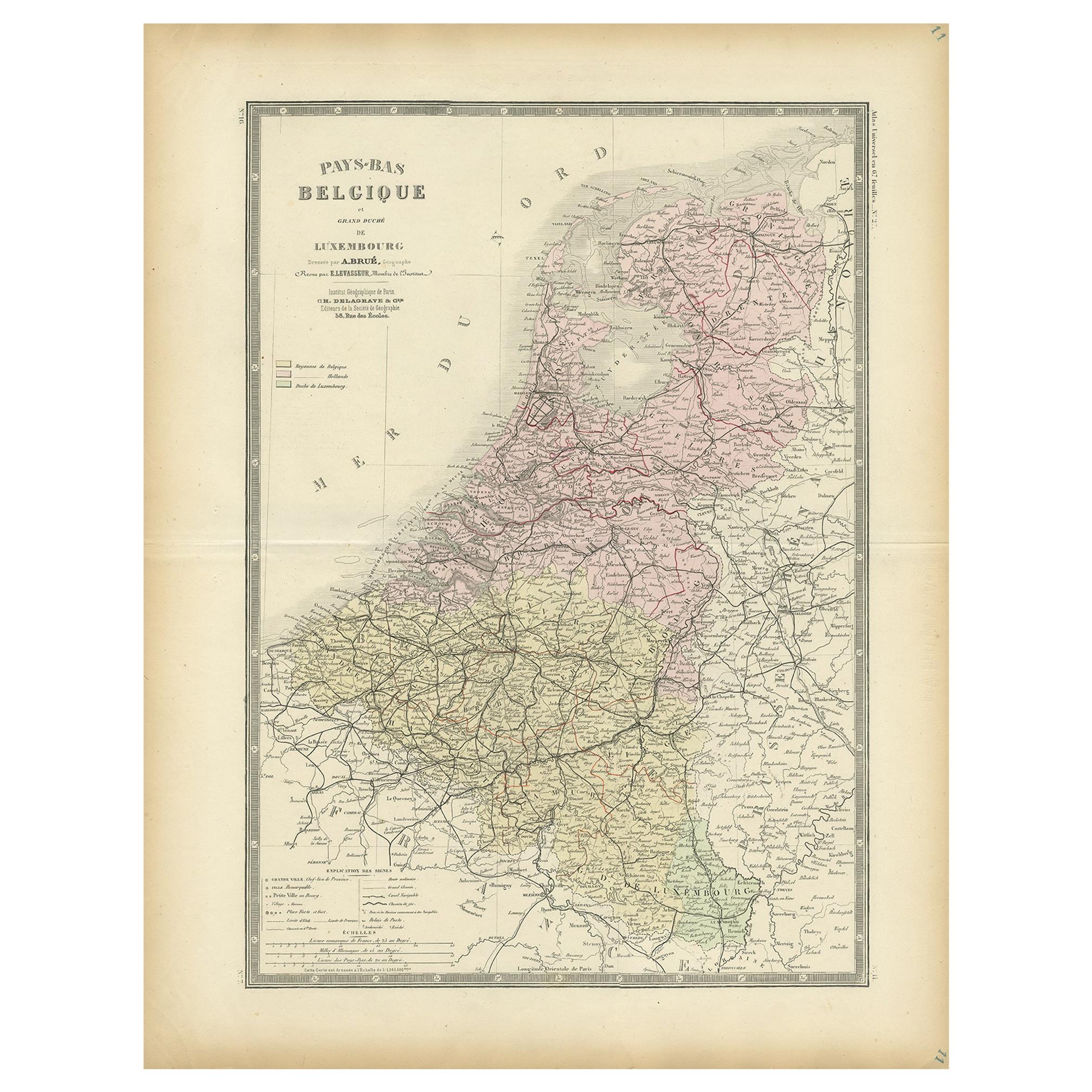
Items Similar to Antique Map of the Netherlands and Belgium by Lapie, 1842
Want more images or videos?
Request additional images or videos from the seller
1 of 5
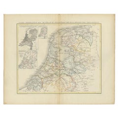
Antique Map of the Netherlands and Belgium by Lapie, 1842
$276.02
$345.0320% Off
£205.95
£257.4420% Off
€231.20
€28920% Off
CA$384.90
CA$481.1220% Off
A$421.66
A$527.0820% Off
CHF 220.27
CHF 275.3420% Off
MX$5,069.24
MX$6,336.5520% Off
NOK 2,753.74
NOK 3,442.1720% Off
SEK 2,597.21
SEK 3,246.5220% Off
DKK 1,760.54
DKK 2,200.6820% Off
About the Item
Antique map titled 'Carte des Royaumes de Belgique et de Hollande'. Map of the Netherlands and Belgium. This map originates from 'Atlas universel de géographie ancienne et moderne (..)' by Pierre M. Lapie and Alexandre E. Lapie.
Artists and Engravers: Pierre M. Lapie was a French cartographer and engraver. He was the father of cartographer Alexandre Emile Lapie.
Condition: Very good, general age-related toning. Original folding line, blank verso. Please study image carefully.
Date: 1842
Overall size: 50.5 x 68 cm.
Image size: 40 x 54.5 cm.
We sell original antique maps to collectors, historians, educators and interior decorators all over the world. Our collection includes a wide range of authentic antique maps from the 16th to the 20th centuries. Buying and collecting antique maps is a tradition that goes back hundreds of years. Antique maps have proved a richly rewarding investment over the past decade, thanks to a growing appreciation of their unique historical appeal. Today the decorative qualities of antique maps are widely recognized by interior designers who appreciate their beauty and design flexibility. Depending on the individual map, presentation, and context, a rare or antique map can be modern, traditional, abstract, figurative, serious or whimsical. We offer a wide range of authentic antique maps for any budget
- Creator:Pierre M. Lapie (Artist)
- Dimensions:Height: 26.78 in (68 cm)Width: 19.89 in (50.5 cm)Depth: 0 in (0.01 mm)
- Materials and Techniques:
- Period:
- Date of Manufacture:1842
- Condition:
- Seller Location:Langweer, NL
- Reference Number:Seller: BG-12338-271stDibs: LU3054327832722
About the Seller
5.0
Recognized Seller
These prestigious sellers are industry leaders and represent the highest echelon for item quality and design.
Platinum Seller
Premium sellers with a 4.7+ rating and 24-hour response times
Established in 2009
1stDibs seller since 2017
2,654 sales on 1stDibs
Typical response time: <1 hour
- ShippingRetrieving quote...Shipping from: Langweer, Netherlands
- Return Policy
Authenticity Guarantee
In the unlikely event there’s an issue with an item’s authenticity, contact us within 1 year for a full refund. DetailsMoney-Back Guarantee
If your item is not as described, is damaged in transit, or does not arrive, contact us within 7 days for a full refund. Details24-Hour Cancellation
You have a 24-hour grace period in which to reconsider your purchase, with no questions asked.Vetted Professional Sellers
Our world-class sellers must adhere to strict standards for service and quality, maintaining the integrity of our listings.Price-Match Guarantee
If you find that a seller listed the same item for a lower price elsewhere, we’ll match it.Trusted Global Delivery
Our best-in-class carrier network provides specialized shipping options worldwide, including custom delivery.More From This Seller
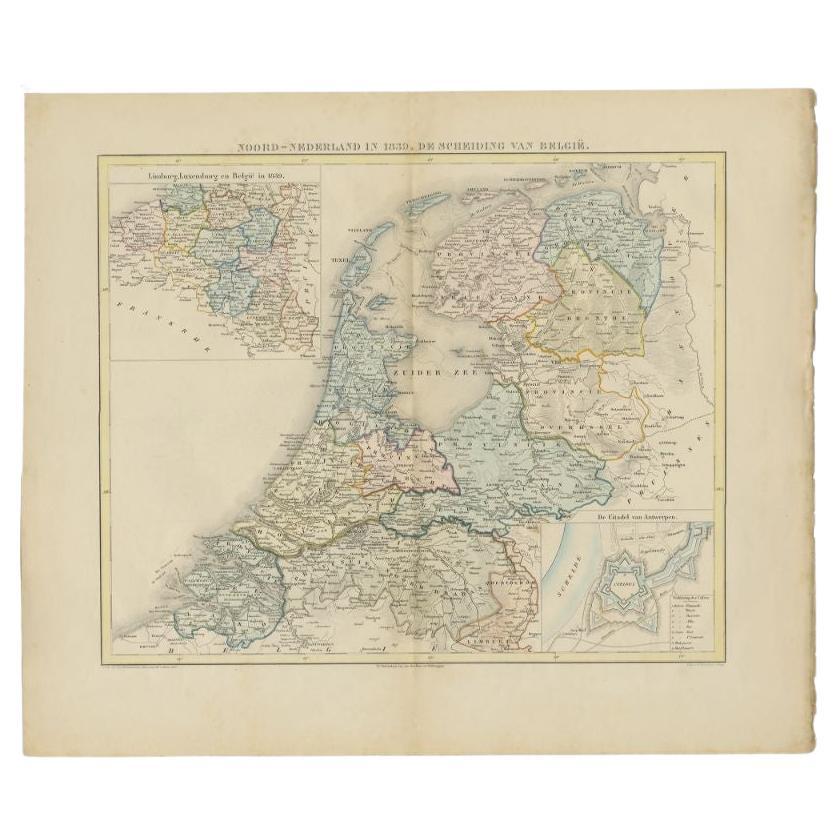
View AllAntique Map of the Netherlands in 1839 by Mees, 1860
Located in Langweer, NL
Antique map titled 'Noord-Nederland in 1839. De scheiding van België'. Map of the Netherlands in 1839. This map originates from 'Historische Atlas van Noord-Nederland'.
Artists a...
Category
Antique 19th Century Maps
Materials
Paper
$122 Sale Price
20% Off
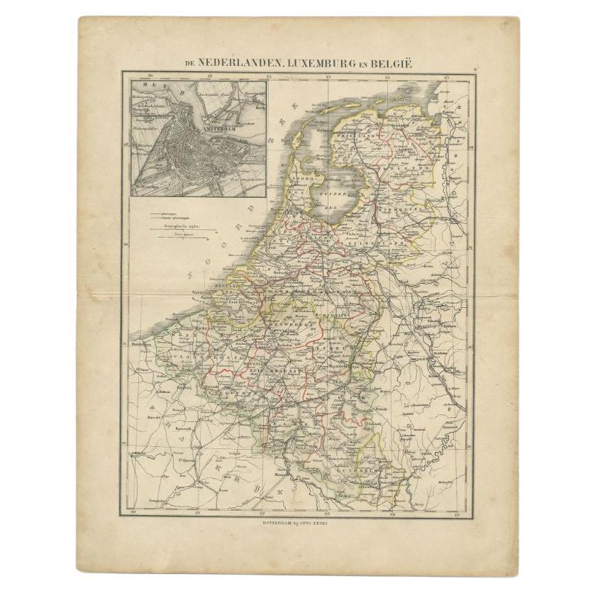
Antique Map of the Netherlands, Belgium and Luxembourg by Petri, c.1873
Located in Langweer, NL
Antique map titled 'De Nederlanden, Luxemburg en België'. Old map depicting the Netherlands, Luxembourg and Belgium. With an inset map of Amsterdam. T...
Category
Antique 19th Century Maps
Materials
Paper
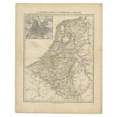
$111 Sale Price
20% Off
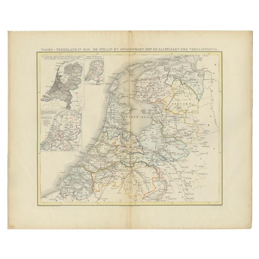
Antique Map of the Netherlands in 1859 by Mees, 1861
Located in Langweer, NL
Antique map titled 'Noord-Nederland in 1859. De Straat- en Spoorwegen met de jaartallen der vervaardiging'. Map of the Netherlands in 1859. This map originates from 'Historische Atla...
Category
Antique 19th Century Maps
Materials
Paper
$122 Sale Price
20% Off
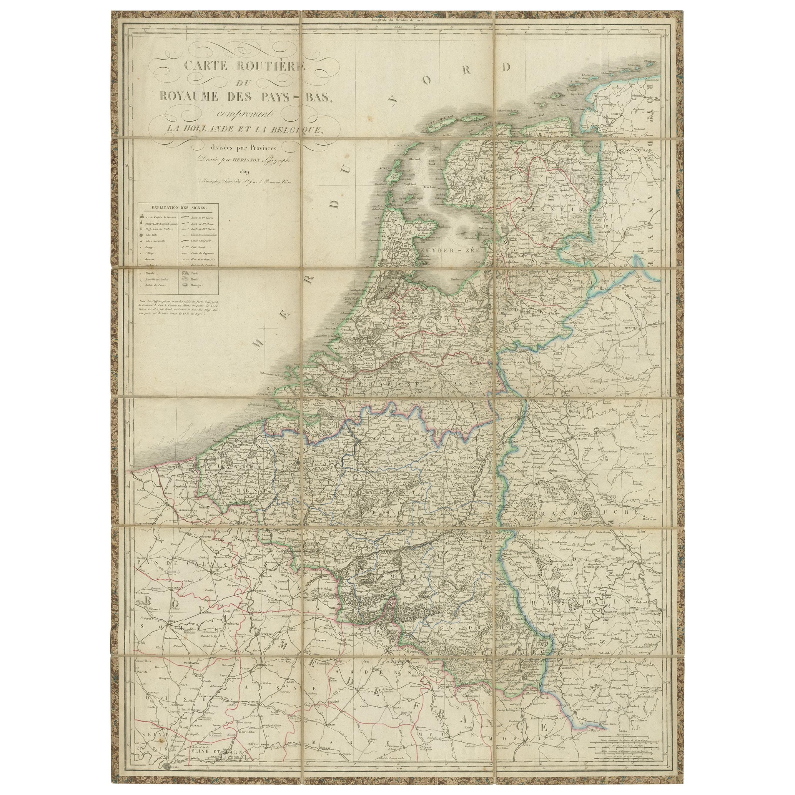
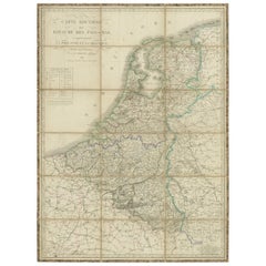
Antique Map of the Netherlands and Belgium by Hérisson, 1829
Located in Langweer, NL
Title: 'Carte Routière du Royaume des Pays-Bas comprenant la Hollande et la Belgique'
**Publisher**: Eustache Hérisson
**Publication Year**: 1829
This original antique map is a detailed depiction of the Netherlands and Belgium, dating back to 1829. As a 'Carte Routière', it focuses on the road networks of the region, providing valuable historical insights into the transportation and geographical understanding of the early 19th century. The map's delineation of the Kingdom of the Netherlands, including both Holland and Belgium, is particularly noteworthy as it represents the political geography of the period shortly before Belgium's independence in 1830.
The map is sectionalised and laid on linen, a common practice in the 19th century for preserving and reinforcing maps, making them more durable and portable. This method of mounting also suggests that the map was intended for practical use, possibly by travelers or for educational purposes.
**Artist and Publisher**: Eustache Hérisson, the publisher of this map, was a known figure in the cartographic and publishing world of the early 19th century. His work is characterized by attention to detail and accuracy, making this map not only a beautiful piece of art but also a reliable historical document.
This map is a valuable historical artifact, offering insights into the geographical and political landscape of the Netherlands...
Category
Antique Mid-19th Century Maps
Materials
Paper
$716 Sale Price
20% Off
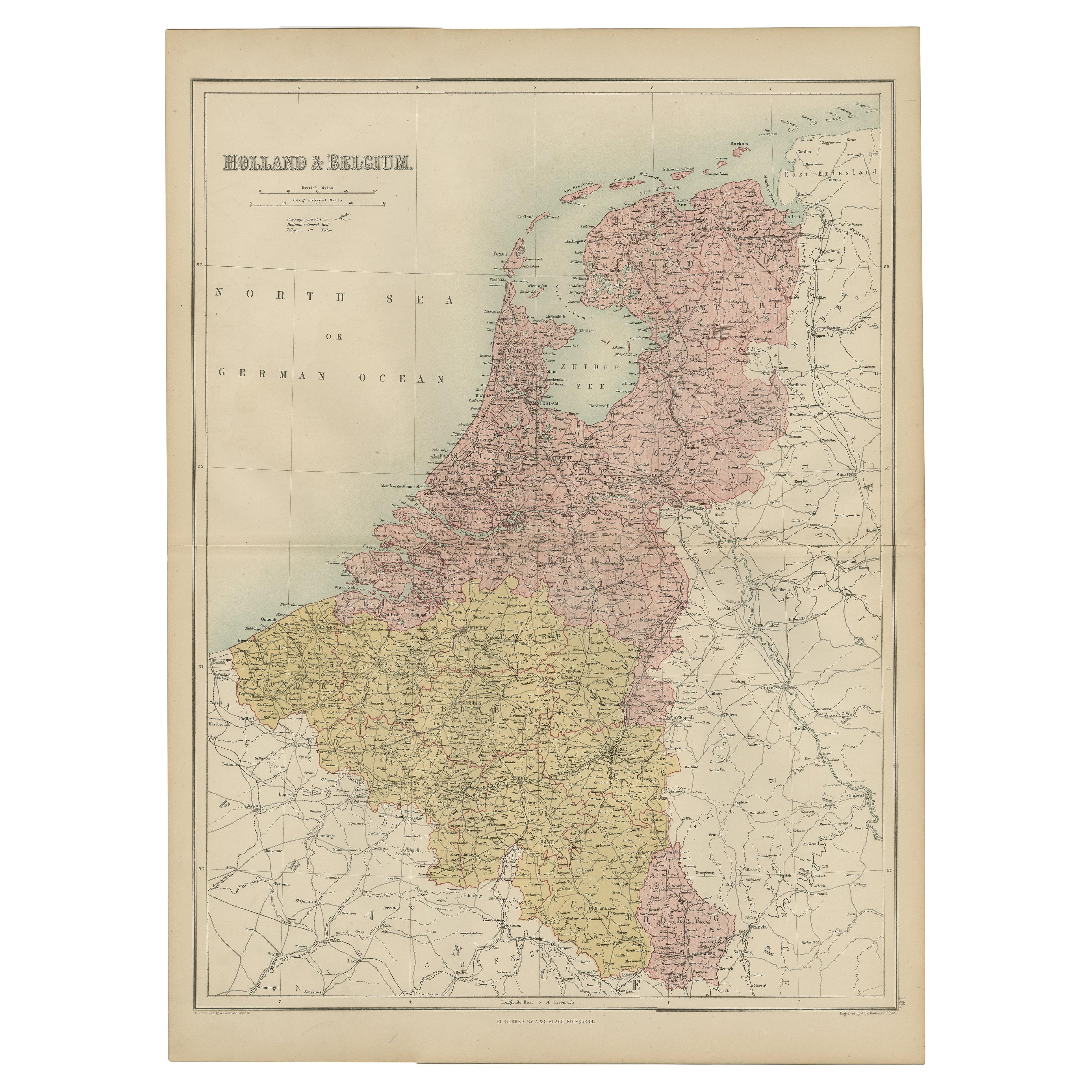
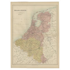
Antique Map of The Netherlands and Belgium by A & C, Black, 1870
Located in Langweer, NL
Antique map titled 'Holland & Belgium'. Original antique map of Map of The Netherlands and Belgium. This map originates from ‘Black's General Atlas of The World’. Published by A & C....
Category
Antique Late 19th Century Maps
Materials
Paper
$238 Sale Price
20% Off
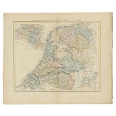
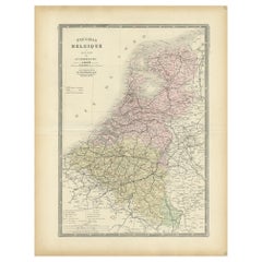
Decorative Antique Map of the Netherlands and Belgium, ca.1875
Located in Langweer, NL
Antique map titled 'Pays-Bas Belgique (..)'. Large map of the Netherlands and Belgium. This map originates from 'Atlas de Géographie Moder...
Category
Antique Late 19th Century Maps
Materials
Paper
$382 Sale Price
20% Off
You May Also Like
1752 Vaugoundy Map of Flanders : Belgium, France, and the Netherlands, Ric.a002
Located in Norton, MA
Large Vaugoundy Map of Flanders:
Belgium, France, and the Netherlands
Colored -1752
Ric.a002
Description: This is a 1752 Didier Robert de Vaugondy map of Flanders. The map de...
Category
Antique 17th Century Unknown Maps
Materials
Paper

The Netherlands (Holland), Belgium and Luxemburg. Century Atlas antique map
Located in Melbourne, Victoria
'The Century Atlas. The Netherlands (Holland), Belgium and Luxemburg.'
Original antique map, 1903.
Inset maps of 'Amsterdam' and 'Brussels'.
Central fold as issued. Map name and num...
Category
Early 20th Century Victorian More Prints
Materials
Lithograph

1839 Map of Karte Des "Russischen Reiches in Europa Und Asien" Ric.R0013
Located in Norton, MA
1839 map of Karte Des
"Russischen Reiches in Europa and Asien"
Ric.r013
Map of the European and Asian parts of Russian Empire. Karte der Russischen Reiches in Europa und Asien...
Category
Antique 19th Century Unknown Maps
Materials
Paper

La Gironde, France. Antique map of a French department, 1856
By Victor Levasseur
Located in Melbourne, Victoria
'La Gironde', steel engraving with original outline hand-colouring., 1856, from Levasseur's 'Atlas National Illustre'.
This coastal department is the seat of the Bordeaux wine regi...
Category
19th Century Naturalistic Landscape Prints
Materials
Engraving

1849 Map of "Europaische Russland", 'Meyer Map of European Russia', Ric. R017
Located in Norton, MA
1849 Map of
"Europaische Russland"
( Meyer Map of European Russia)
Ric.r017
A lovely map of European Russia dating to 1849 by Joseph Meyer. It covers the European portions of...
Category
Antique 19th Century Unknown Maps
Materials
Paper

1853 Map of "Russia in Europe Including Poland" Ric.r016
Located in Norton, MA
Description
Russia in Europe incl. Poland by J Wyld c.1853
Hand coloured steel engraving
Dimension: Paper: 25 cm W x 33 cm H ; Sight: 22 cm W x 28 cm H
Condition: Good ...
Category
Antique 19th Century Unknown Maps
Materials
Paper

More Ways To Browse
Antique Map Of Venice
Charlotte Reine
Cleveland Antique Furniture
Gambia Antique Map
Johann Baptist Homann On Sale
Magellan Map
Map Of Puerto Rico
Map Ukraine
Papua New Guinea Antique Map
Serbia Antique Map
Stanford Antique Furniture
Tipu Sultan
Used Office Furniture Cornwall
Vintage Wooden Roller
Albania Antique Map
Ancient Bible
Antique Bermuda Furniture
Antique Constellation Map