Items Similar to Antique Map op Siberia and Chinese Tartary with original hand coloring, 1732

Want more images or videos?
Request additional images or videos from the seller
1 of 6
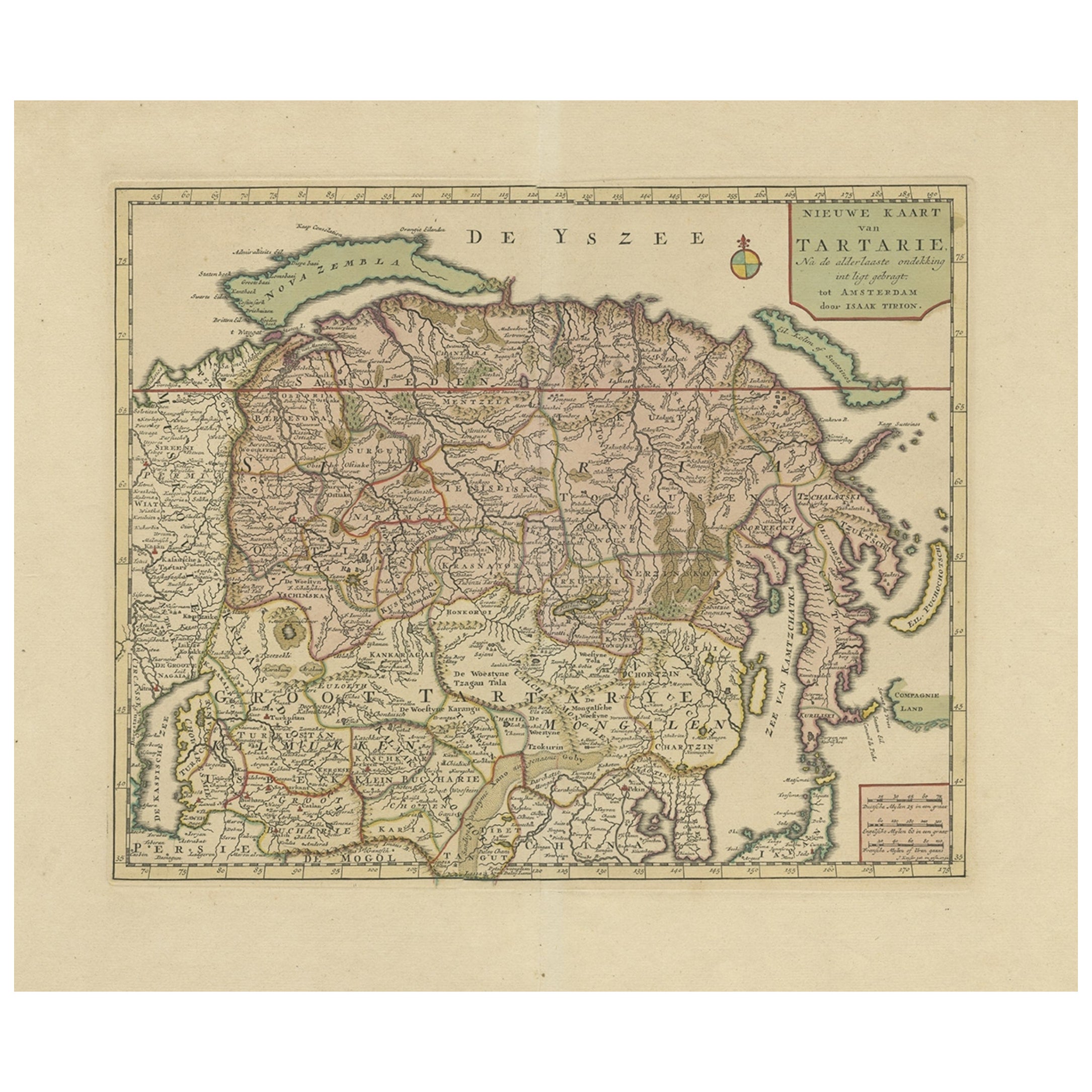
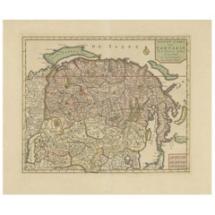
Antique Map op Siberia and Chinese Tartary with original hand coloring, 1732
About the Item
Antique map titled 'Nieuwe Kaart van Tartarie na de alderlaatste ontdekking int ligt gebragt'. Map op Siberia and Chinese tartary. In the north Novaya Zemlya curls back to attach itself to the mainland by a narrow isthmus. In the east Kamchatka reaches down almost to Japan. Published by I. Tirion, circa 1732.
- Dimensions:Height: 16.7 in (42.4 cm)Width: 21.5 in (54.6 cm)Depth: 0.02 in (0.5 mm)
- Materials and Techniques:Paper,Engraved
- Period:
- Date of Manufacture:c.1732
- Condition:Repaired: Repair on folding line and tear top margin. Original/contemporary hand coloring. Original folding line. Shows some wear and soiling. Blank verso. Please study image carefully.
- Seller Location:Langweer, NL
- Reference Number:Seller: BG-13513-41stDibs: LU3054336261822
About the Seller
5.0
Recognized Seller
These prestigious sellers are industry leaders and represent the highest echelon for item quality and design.
Gold Seller
Premium sellers maintaining a 4.3+ rating and 24-hour response times
Established in 2009
1stDibs seller since 2017
2,446 sales on 1stDibs
Typical response time: 1 hour
- ShippingRetrieving quote...Shipping from: Langweer, Netherlands
- Return Policy
Authenticity Guarantee
In the unlikely event there’s an issue with an item’s authenticity, contact us within 1 year for a full refund. DetailsMoney-Back Guarantee
If your item is not as described, is damaged in transit, or does not arrive, contact us within 7 days for a full refund. Details24-Hour Cancellation
You have a 24-hour grace period in which to reconsider your purchase, with no questions asked.Vetted Professional Sellers
Our world-class sellers must adhere to strict standards for service and quality, maintaining the integrity of our listings.Price-Match Guarantee
If you find that a seller listed the same item for a lower price elsewhere, we’ll match it.Trusted Global Delivery
Our best-in-class carrier network provides specialized shipping options worldwide, including custom delivery.More From This Seller
View AllAntique Map of Siberia and Chinese Tartary, Incl Nova Zembla, ca.1732
Located in Langweer, NL
Antique map of Tartary titled 'Nieuwe Kaart van Tartarie na de alderlaatste ondekking int ligt gebracht tot Amsterdam door Isaak Tirion'.
Map op Siberia and Chinese tartary. In t...
Category
Antique 1730s Maps
Materials
Paper
$797 Sale Price
20% Off
Free Shipping
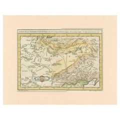
Antique Map of Tartary and Northeast Asia with Hand Coloring
Located in Langweer, NL
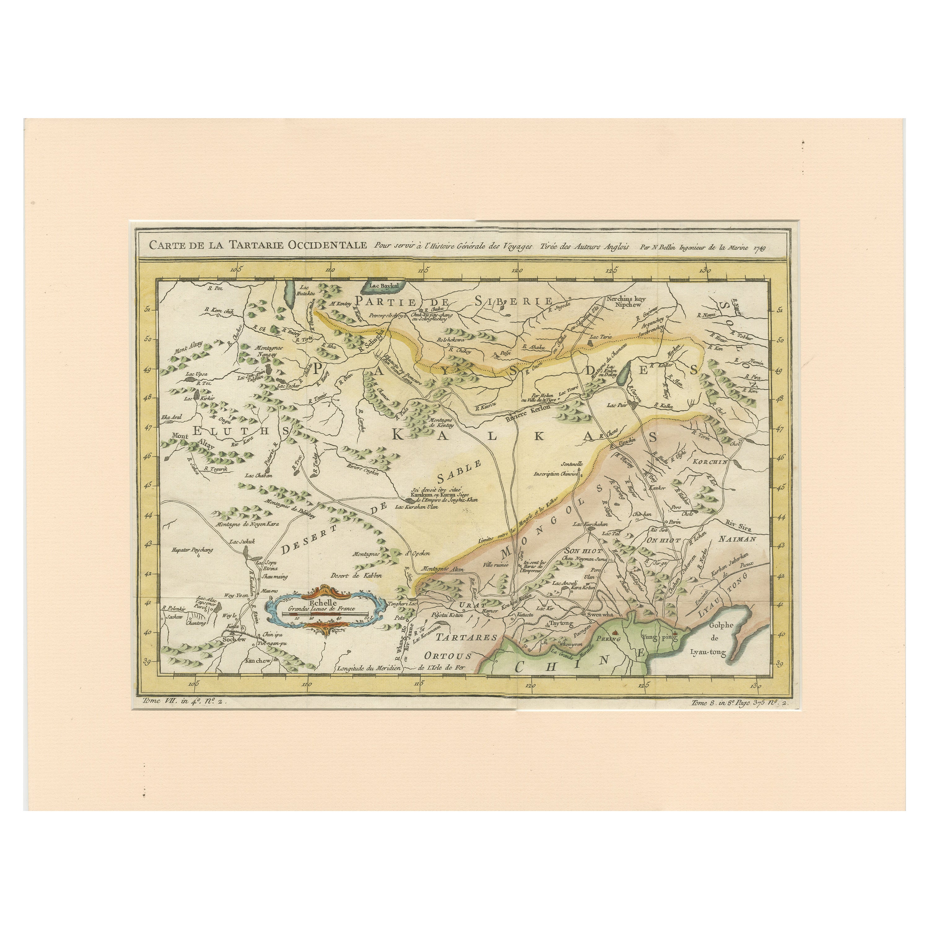
Antique map titled 'Carte de la Tartarie Occidentale'. An interesting map of Tartary and northeast Asia, from Lake Baykal, Partie du Siberia in the north, Pays des Kalkas at the cent...
Category
Antique Mid-18th Century Maps
Materials
Paper
$259 Sale Price
20% Off
Original Antique Map of England with Hand Coloring
Located in Langweer, NL
Antique map titled 'Engand'. Original old map of England. Engraved by W. Milton. Published by John Mc. Gowan, circa 1829.
Category
Antique Mid-19th Century Maps
Materials
Paper

$204 Sale Price
20% Off
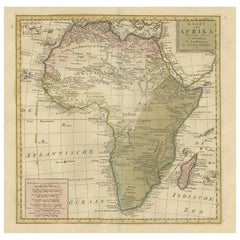
Antique Map of Africa with Original Hand Coloring
Located in Langweer, NL
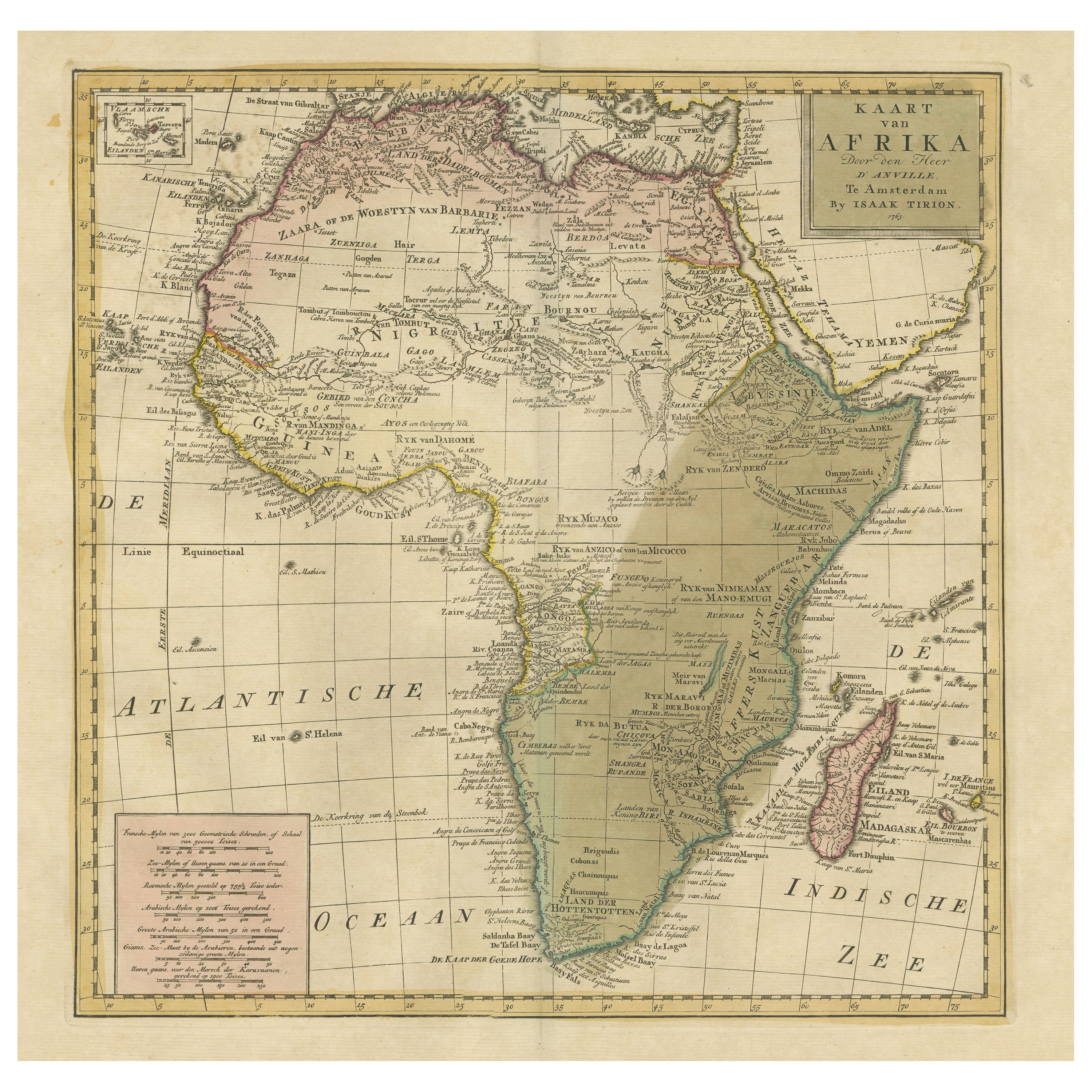
Antique map titled 'Kaart van Afrika door den Heer d'Anville'. Detailed original old map of Africa, with very small inset map titled 'Vlaamsche Eilanden', which shows the Azores. Pub...
Category
Antique Mid-18th Century Maps
Materials
Paper
$723 Sale Price
20% Off
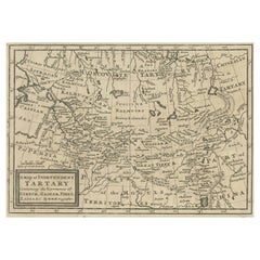
Old Map of Tartary with Persia, Siberia, the Mogul Territories & China, ca.1717
Located in Langweer, NL
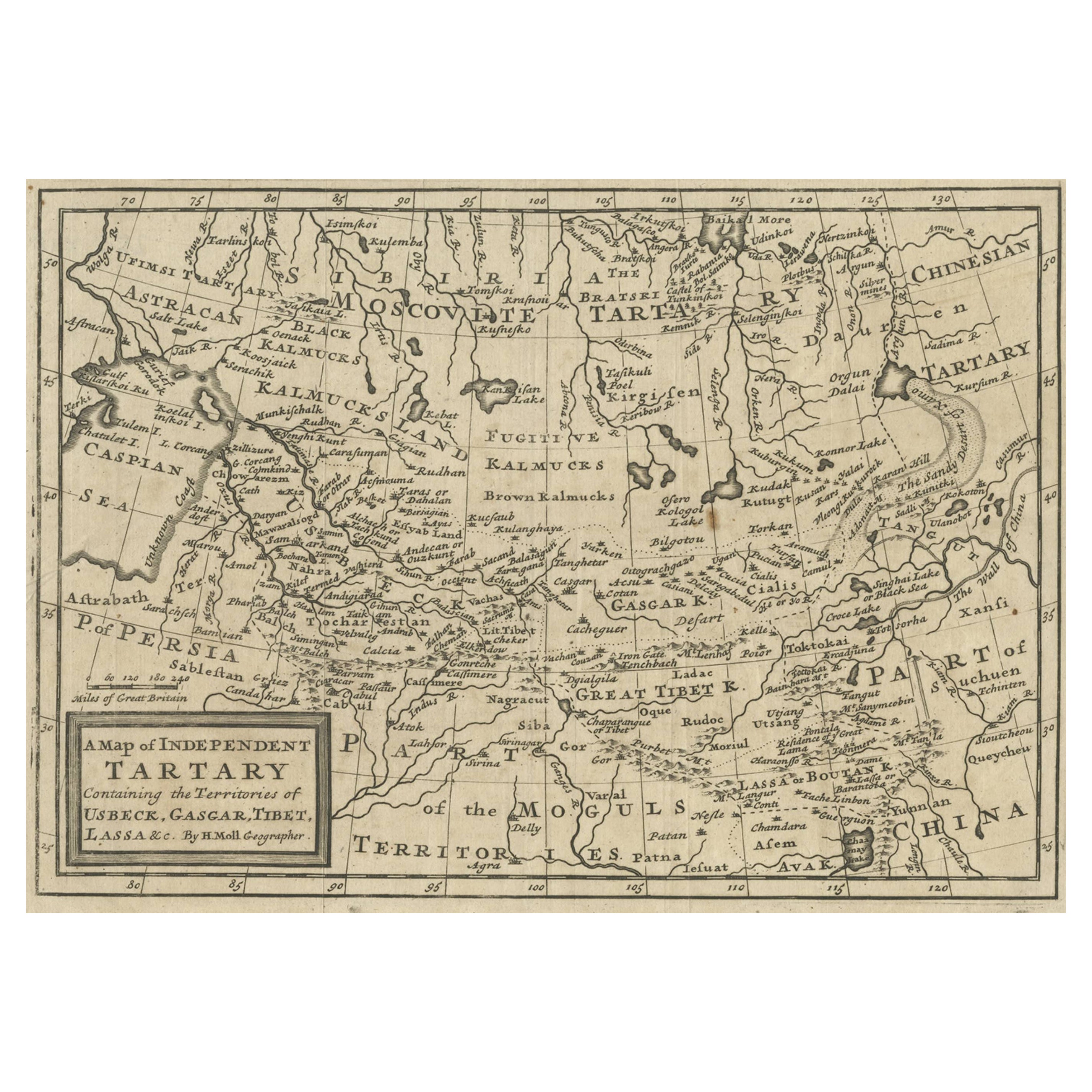
Antique map titled 'A Map of Independent Tartary, containing the territories of Usbeck, Gasgar, Tibet, Lassa & c'.
Old map depicting east of the Caspian Sea with parts of Persia, Siberia, the Mogul territories and on to western China...
Category
Antique 1710s Maps
Materials
Paper
$324 Sale Price
20% Off
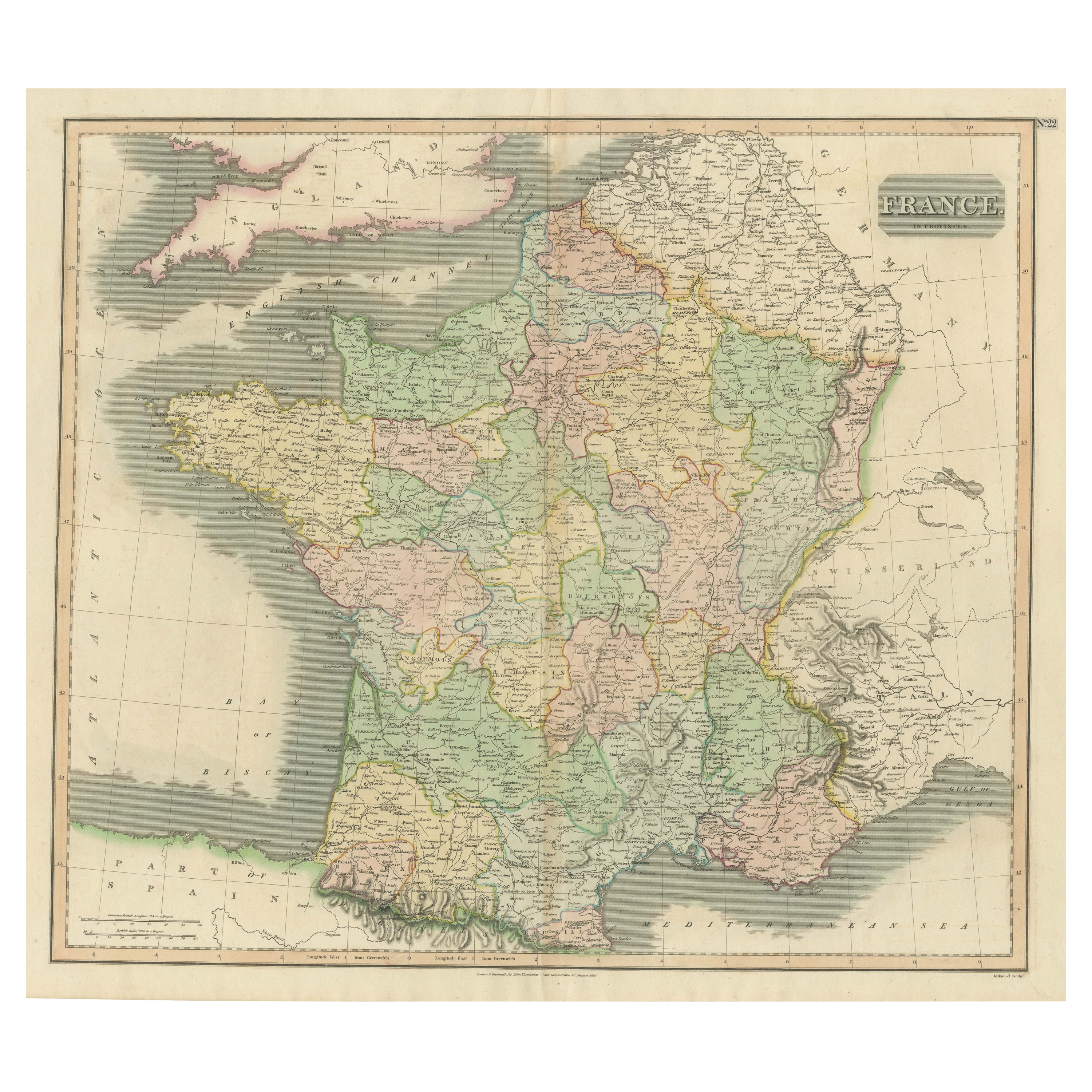
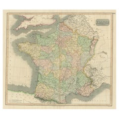
Large Antique Map of France with Original Hand Coloring
Located in Langweer, NL
Antique map titled 'France in Provinces'. Beautiful antique map of France. Drawn and engraved for John Thomson's 'New General Atlas' published circa 1814.
Category
Antique Early 19th Century Maps
Materials
Paper
$408 Sale Price
20% Off
You May Also Like
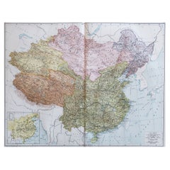
Original Antique Map of China, Arrowsmith, 1820
Located in St Annes, Lancashire
Great map of China
Drawn under the direction of Arrowsmith
Copper-plate engraving
Published by Longman, Hurst, Rees, Orme and Brown, 1820
Unfr...
Category
Antique 1820s English Maps
Materials
Paper

1851 Map of "Independent Tartary", Ric. R018
Located in Norton, MA
1851 Map of
Independent Tartary
"Russia"
Ric.r018
A highly decorative 1851 map of Independent Tartary by John Tallis and John Rapkin. Covers the regions between the Caspian Sea and Lake Bakquash and between Russia and Afghanistan. These include the ancient Silk Route kingdoms of Khiva, Tartaria, Kokand, and Bokhara. Today this region roughly includes Kazakhstan, Uzbekistan, Turkmenistan, Kyrgyzstan, and Tajikistan. This wonderful map offers a wealth of detail for anyone with an interest in the Central Asian portion of the ancient Silk Road. Identifies various caravan routes, deserts, wells, and stopping points, including the cities of Bokhara and Samarkand. Three vignettes by W. Bragg decorate the map, these including an image of Tartars on a Journey, a horseback Bride Chase, and a tartar camp site. Surrounded by a vine motif border. Engraved by J. Rapkin for John Tallis's 1851 Illustrated Atlas .
Tartary Antique Map...
Category
Antique 19th Century Unknown Maps
Materials
Paper

Large Original Vintage Map of China, circa 1920
Located in St Annes, Lancashire
Great map of China.
Original color. Good condition.
Published by Alexander Gross
Unframed.
Category
Vintage 1920s English Edwardian Maps
Materials
Paper
Original Antique Map of Ireland- Tipperary and Waterford. C.1840
Located in St Annes, Lancashire
Great map of Tipperary and Waterford
Steel engraving
Drawn under the direction of A.Adlard
Published by How and Parsons, C.1840
Unframed.
Category
Antique 1840s English Maps
Materials
Paper

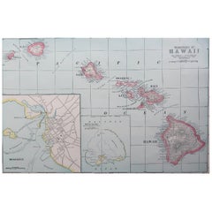
Original Antique Map of Hawaii And Adjacent Islands. C.1900
Located in St Annes, Lancashire
Fabulous map of Hawaii. With a vignette of Honolulu
Original color.
Engraved and printed by the George F. Cram Company, Indianapolis.
Published, C.1900.
Unframed.
Free shipping.
Category
Antique 1890s American Maps
Materials
Paper
Original Antique Map of Spain and Portugal, circa 1790
Located in St Annes, Lancashire
Super map of Spain and Portugal
Copper plate engraving by A. Bell
Published, circa 1790.
Unframed.
Category
Antique 1790s English Other Maps
Materials
Paper

Recently Viewed
View AllMore Ways To Browse
Niels Moller Teak Dining Chairs
Off White Cocktail Table
Oval English Dining Table
Oversized Afghan Rugs
Pair Bent Wood Chairs
Pairs Of Antique Empire Chairs
Pink Mid Century Side Table
Pj Rare
Porcelain Teacup Set
Poul Kjaerholm Coffee Table
Pretzel Chairs
Purple Vintage Oushak
Rasmus Denmark
Rattan Two Tier
Red Leather Swivel Chair
Rosewood Vintage Armchair
Royal Sienna
Rush Back Armchairs