Items Similar to Antique Map of Overijssel by Brugsma, 1864

Want more images or videos?
Request additional images or videos from the seller
1 of 5
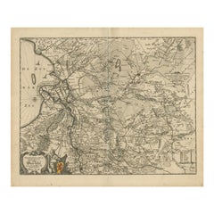
Antique Map of Overijssel by Brugsma, 1864
About the Item
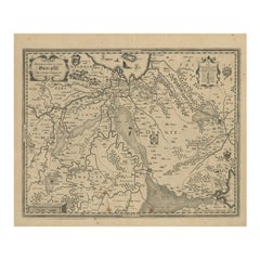
Antique map titled 'De Provincie Overijssel'. Map of the province of Overijssel, the Netherlands. This map originates from 'F. C. Brugsma's Atlas van het Koninkrijk der Nederlanden (..)'. Artists and Engravers: Author: Frederik Carel Brugsma. Published by J.B. Wolters.
Artist: Author: Frederik Carel Brugsma. Published by J.B. Wolters.
Condition: Good, general age-related toning. Original folding line, minor wear. Blank verso. Please study image carefully.
Date: 1864
Overall size: 30.5 x 25.5 cm.
Image size: 0.001 x 23.5 x 20.5 cm.
Antique prints have long been appreciated for both their aesthetic and investment value. They were the product of engraved, etched or lithographed plates. These plates were handmade out of wood or metal, which required an incredible level of skill, patience and craftsmanship. Whether you have a house with Victorian furniture or more contemporary decor an old engraving can enhance your living space. We offer a wide range of authentic antique prints for any budget.
- Dimensions:Height: 10.04 in (25.5 cm)Width: 12.01 in (30.5 cm)Depth: 0 in (0.01 mm)
- Materials and Techniques:
- Period:
- Date of Manufacture:1864
- Condition:
- Seller Location:Langweer, NL
- Reference Number:
About the Seller
5.0
Platinum Seller
These expertly vetted sellers are 1stDibs' most experienced sellers and are rated highest by our customers.
Established in 2009
1stDibs seller since 2017
1,929 sales on 1stDibs
Typical response time: <1 hour
- ShippingRetrieving quote...Ships From: Langweer, Netherlands
- Return PolicyA return for this item may be initiated within 14 days of delivery.
More From This SellerView All
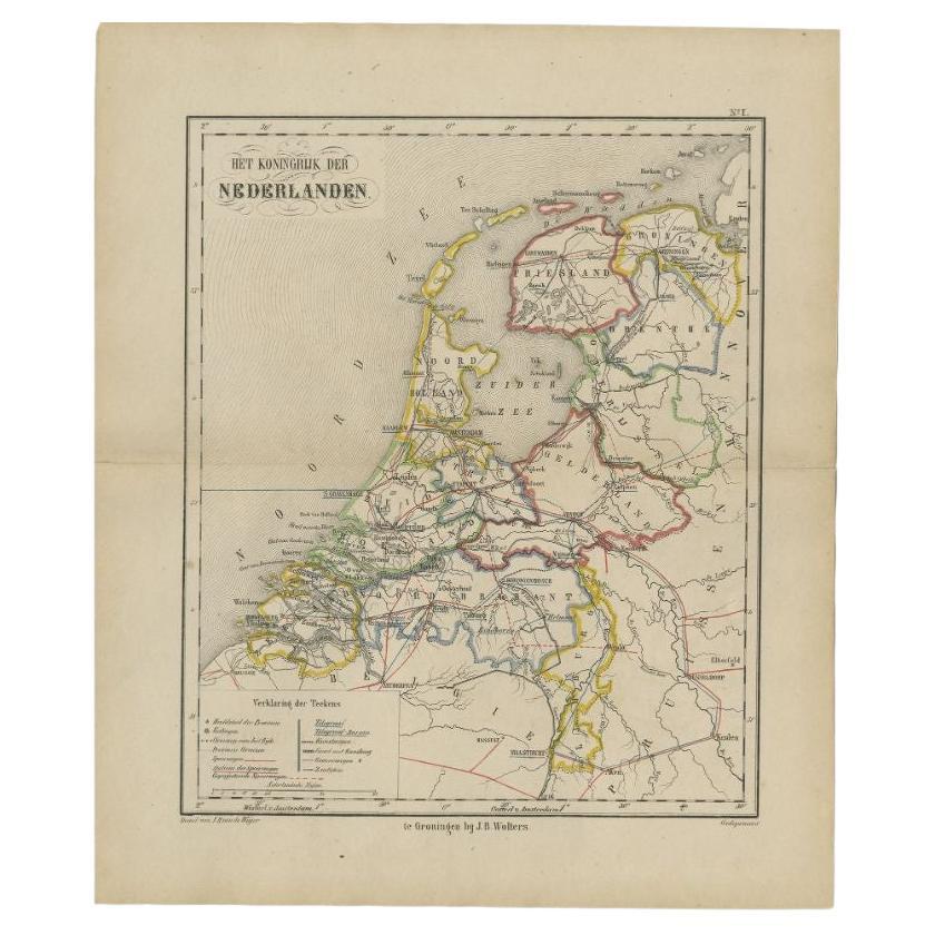
- Antique Map of the Netherlands by Brugsma, 1864Located in Langweer, NLAntique map titled 'Het Koningrijk der Nederlanden'. Map of the Netherlands. This map originates from 'F. C. Brugsma's Atlas van het Koninkrijk ...Category
Antique 19th Century Maps
MaterialsPaper
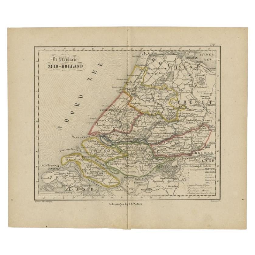
- Original Antique Map of Zuid-Holland by Brugsma, 1864Located in Langweer, NLAntique map titled 'De Provincie Zuid-Holland'. Map of the province of Zuid-Holland, the Netherlands. This map originates from 'F. C. Brugsma's Atlas van het Koninkrijk der Nederland...Category
Antique 19th Century Maps
MaterialsPaper
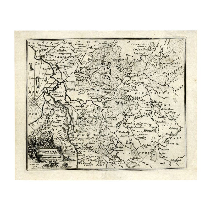
- Antique Map of Overijssel by Bachiene, 1758Located in Langweer, NLAntique map titled 'Over-Yssel'. Map of the Overijssel, the Netherlands. This map originates from 'Kort begrip der Oude en Nieuwe Staatkundige Geographie', by W.A. Bachiene, publishe...Category
Antique 18th Century Maps
MaterialsPaper
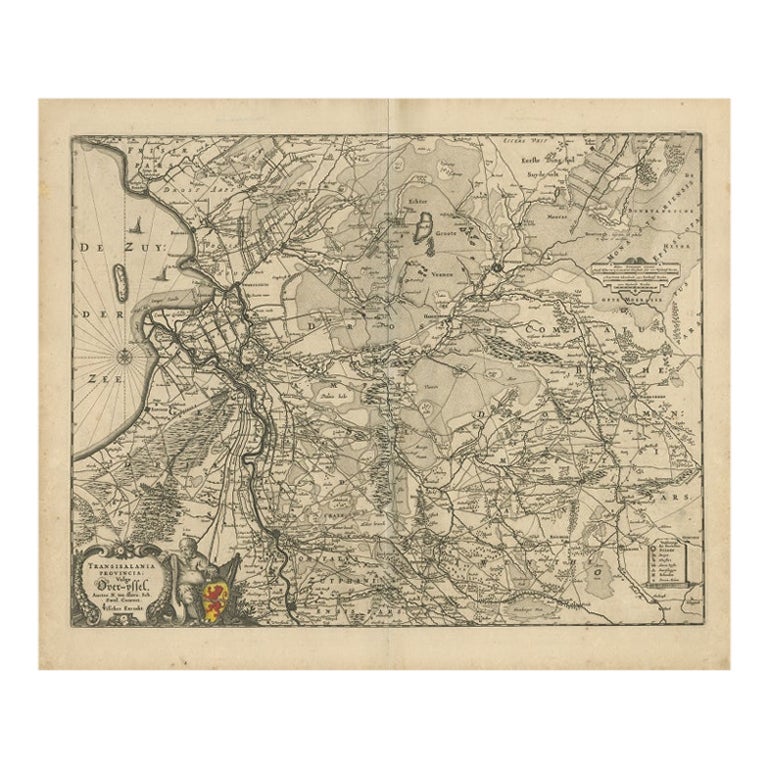
- Antique Map of Overijssel by Visscher, 1632Located in Langweer, NLAntique map titled 'De Heerlyckheyt van Over-IJssel'. Old map of the province of Overijssel, the Netherlands. Also depicted are various coats of arms. Artists and Engravers: Engraved...Category
Antique 17th Century Maps
MaterialsPaper
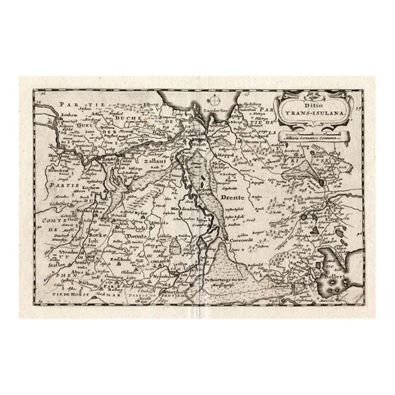
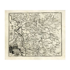
- Antique Map of Overijssel by Colom, 1635Located in Langweer, NLAntique map titled 'Ditio Trans-Isulana'. Original antique map of the province of Overijssel, the Netherlands. This map originates from 'Vyerige Colom verthonende de 17 Nederlandsche...Category
Antique 17th Century Maps
MaterialsPaper
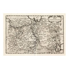
- Antique Map of Overijssel by Visscher, c.1652Located in Langweer, NLAntique map titled 'Transisalania provincia vulgo Over-yssel'. Original antique map of the province of Overijssel, the Netherlands. Published by N. Visscher after N. ten Have, circa ...Category
Antique 17th Century Maps
MaterialsPaper


You May Also Like
- 1864 Map of North America, Antique Hand-Colored Map, by Adolphe Hippolyte DufourLocated in Colorado Springs, COOffered is a map of North America entitled Amerique du Nord from 1864. This rare, separately published wall map was produced by Adolphe Hippolyte Dufour. This map includes vibrant an...Category
Antique 1860s French Maps
MaterialsPaper
- Important Confederate Field Map of Richmond VA 1864 with ProvenanceLocated in Dallas, TXPRESENTING AN HISTORIC AND EXCEPTIONALLY RARE AND IMPORTANT American Civil War Collection consisting of: (1) ORIGINAL and FULLY AUTHENTIC Confederate Field Map of Richmond, VA 1864 belonging to Capt W.A. Obenchain C.S. Engineers, (2) ORIGINAL and FULLY AUTHENTIC Surrender/Parole Paper for Capt. W.A. Obenchain dated 1st May 1865 at Greensboro, NC (3) ORIGINAL and FULLY AUTHENTIC Pamphlet for Hillsborough Military Academy, NC with Major W.M. A. Obenchain listed as 'Military Staff'. These ALL belonged to Captain (later promoted to rank of Major) William Alexander Obenchain and the battlefield map was his 'personal' field map for the Battle of the Richmond Peninsula in 1864, at the end of the US Civil War...Category
Antique Mid-19th Century American American Classical Historical Memorabilia
MaterialsCanvas, Paper
- 1864 "Proclamation of Emancipation, " Antique Engraving by Charles ShoberLocated in Colorado Springs, COThis 1865 engraving features the Emancipation Proclamation in elaborate calligraphic text, with five patriotic vignettes and a small portrait...Category
Antique 1860s American Historical Memorabilia
MaterialsPaper
- 1864 Johnson's Map of the World on Mercator's Projection, Ric.B009Located in Norton, MAAn 1864 Johnson's map of the World on Mercator's Projection Ric.b009 About this Item "This antique map came from Johnson's New Illustrated (Steel Plate) Family Atlas, publ...Category
Antique 19th Century Dutch Maps
MaterialsPaper
- 1861 Topographical Map of the District of Columbia, by Boschke, Antique MapLocated in Colorado Springs, COPresented is an original map of Albert Boschke's extremely sought-after "Topographical Map of the District of Columbia Surveyed in the Years 1856 ...Category
Antique 1860s American Historical Memorabilia
MaterialsPaper
- 1907 Map of Colorado, Antique Topographical Map, by Louis NellLocated in Colorado Springs, COThis highly detailed pocket map is a topographical map of the state of Colorado by Louis Nell from 1907. The map "has been complied from all availabl...Category
Antique Early 1900s American Maps
MaterialsPaper


Recently Viewed
View AllMore Ways To Browse
J Blank
A J B Engraving
Metal Plate Engraved B
Old Antique Globes
Antique Scottish Wood Furniture
Scotland Antique Map
Antique Scotland Map
Antique Maps Of New York
Antique Map Of New York
Antique London Map Print
Rare Compass
Map Of United Kingdom
Antique Presentation Plates
Antique Map Fair
Antique Mallet
Antique 16th Century Plates
Antique Caribbean Furniture
Antique Booksellers