Items Similar to Antique Map of Part of Germany by Moll, c.1740
Want more images or videos?
Request additional images or videos from the seller
1 of 5
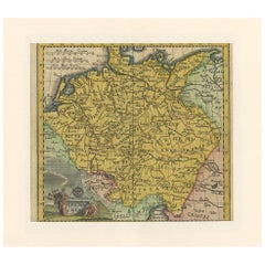
Antique Map of Part of Germany by Moll, c.1740
About the Item
Antique map Germany titled 'The North West Part of Germany; Containing ye Dominions of ye Arch: and El: of Cologne, Westphalia, / Juliers, Cleeves, Munster, Osnaburgh, Holstein, Bremen, / Hanover, Lunenburgh and Brunswick, Hesse-Cassel, &c'. Antique map of North West Germany. Depicts the United Provinces (the Dutch Republic), Westphalia, and Lower Saxony, with parts of Saxony and Franconia in the east. Originates from 'Modern History: or the Present State of All Nations' by T. Salmon. Artists and Engravers: Herman Moll (1654 - 1732), was a London cartographer, engraver and publisher.
Artist: Herman Moll (1654 - 1732), was a London cartographer, engraver and publisher.
Condition: Good, general age-related toning. Few holes in- and outside the map. Please study image carefully.
Date: c.1740
Overall size: 27 x 19 cm.
Image size: 0.001 x 24.5 x 17.5 cm.
Antique prints have long been appreciated for both their aesthetic and investment value. They were the product of engraved, etched or lithographed plates. These plates were handmade out of wood or metal, which required an incredible level of skill, patience and craftsmanship. Whether you have a house with Victorian furniture or more contemporary decor an old engraving can enhance your living space. We offer a wide range of authentic antique prints for any budget.
- Dimensions:Height: 7.49 in (19 cm)Width: 10.63 in (27 cm)Depth: 0 in (0.01 mm)
- Materials and Techniques:
- Period:
- Date of Manufacture:circa 1740
- Condition:
- Seller Location:Langweer, NL
- Reference Number:
About the Seller
5.0
Platinum Seller
These expertly vetted sellers are 1stDibs' most experienced sellers and are rated highest by our customers.
Established in 2009
1stDibs seller since 2017
1,922 sales on 1stDibs
Typical response time: <1 hour
- ShippingRetrieving quote...Ships From: Langweer, Netherlands
- Return PolicyA return for this item may be initiated within 14 days of delivery.
More From This SellerView All
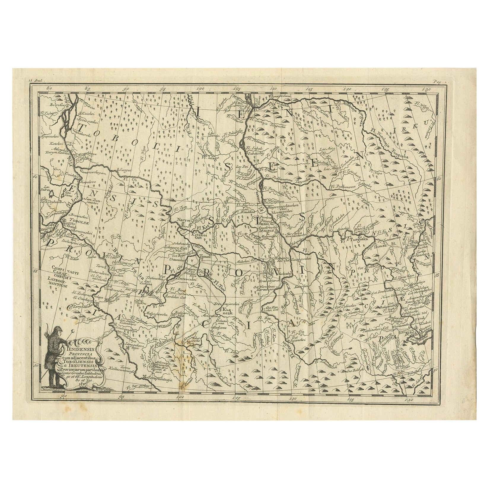
- Antique Map of Part of Russia, c.1740Located in Langweer, NLAntique map titled 'Ienisensis Provinicia cum adjacentibus Toboliensis & Irkutensis'. Old map of part of Russia including the city of Tobolsk and others. Source unknown, to be determ...Category
Antique 18th Century Maps
MaterialsPaper
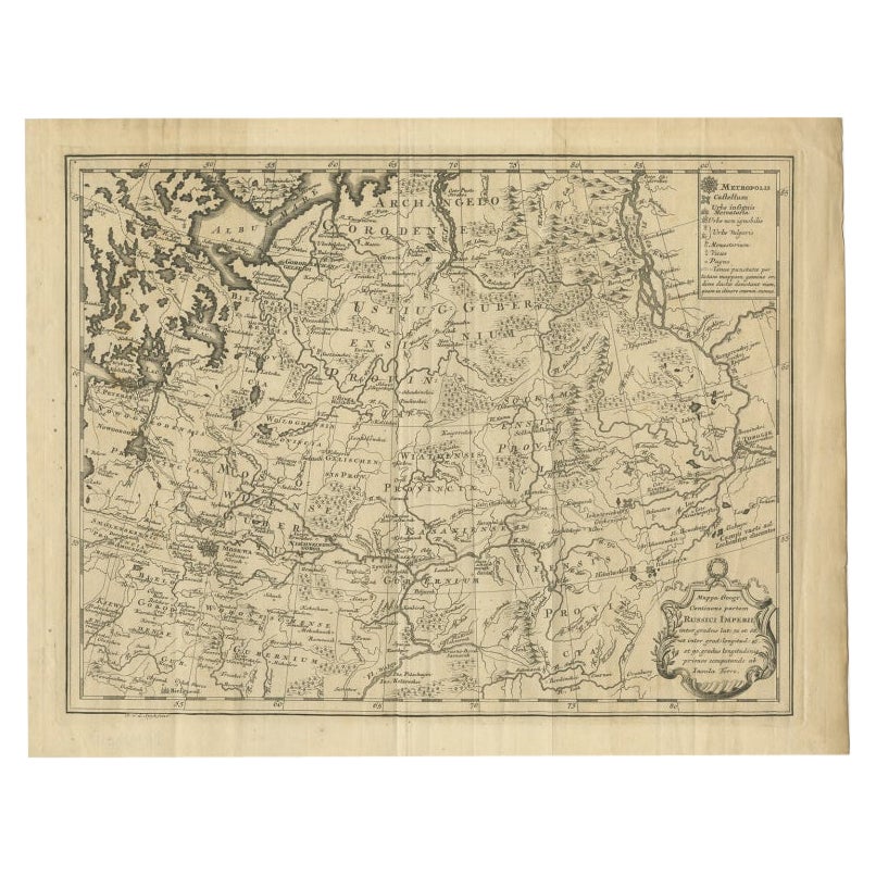
- Antique Map of Part of Russia by Spyk, c.1740Located in Langweer, NLAntique map titled 'Mappa Geogr: Continens partem Russici Imperii (..)'. Old map of part of Russia including the city of Moscow, Vologda, Tobolsk and others. Source unknown, to be de...Category
Antique 18th Century Maps
MaterialsPaper
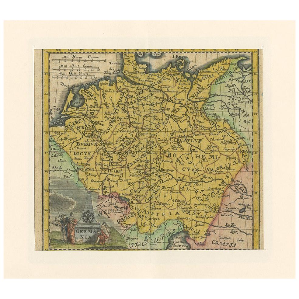
- Antique Map of Germany by Hederichs 'circa 1740'Located in Langweer, NLAntique map titled 'Germania'. Rare miniature map of Germany and surroundings. This map covers the entirety of those lands traditionally occupied by Germanic peoples, from the Blatic...Category
Antique Mid-18th Century Maps
MaterialsPaper
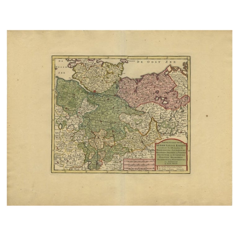
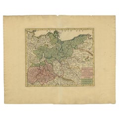
- Antique Map of Lower Saxony in Germany, c.1740Located in Langweer, NLAntique map titled 'Nieuwe Kaart van de Neder Saxise Kreits (..).' Attractive detailed map showing Lower Saxony, Germany, including Mekelenburg, Lauwenburg, Holstein, Bremen, Verden ...Category
Antique 18th Century Maps
MaterialsPaper
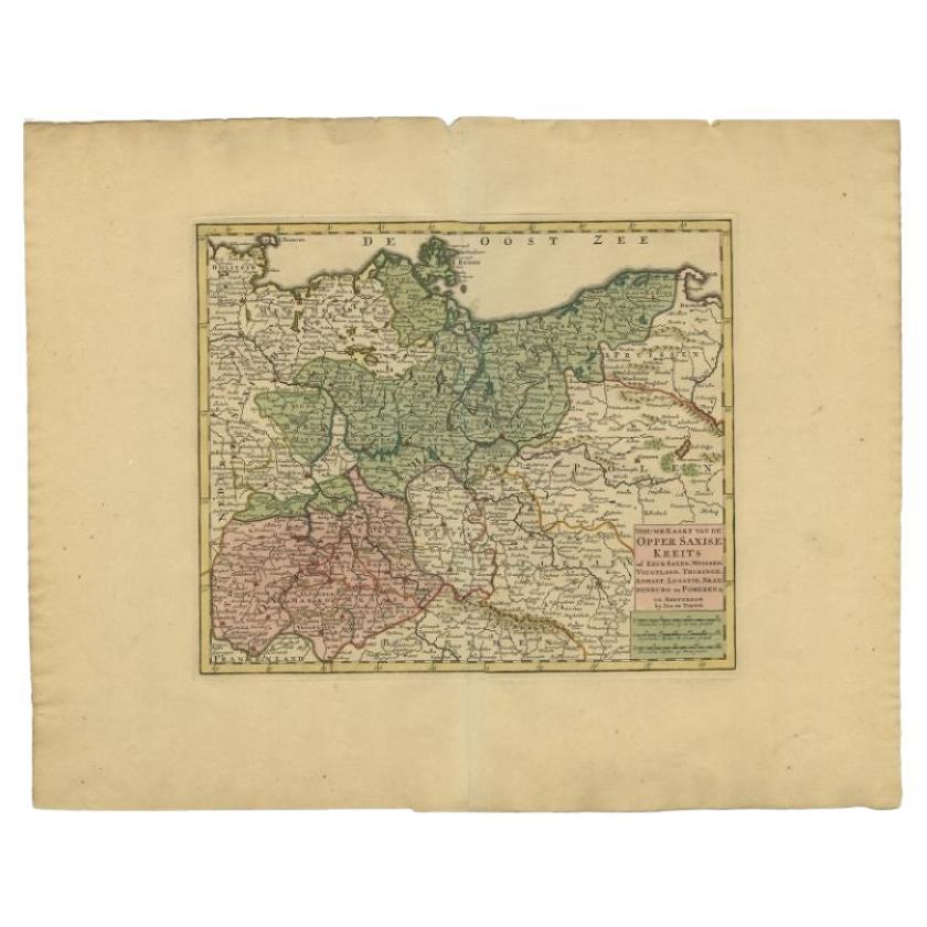
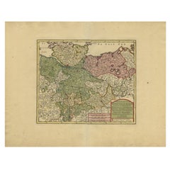
- Antique Map of Upper Saxony in Germany by Tirion, circa 1740By Isaak TirionLocated in Langweer, NLAntique map titled 'Nieuwe Kaart van de Opper Saxise Kreits (..).' Attractive detailed map showing Upper Saxony, Germany with Meissen, Thuringen, Anhalt, Brandenburg, Pommeren etc. S...Category
Antique 18th Century Maps
MaterialsPaper
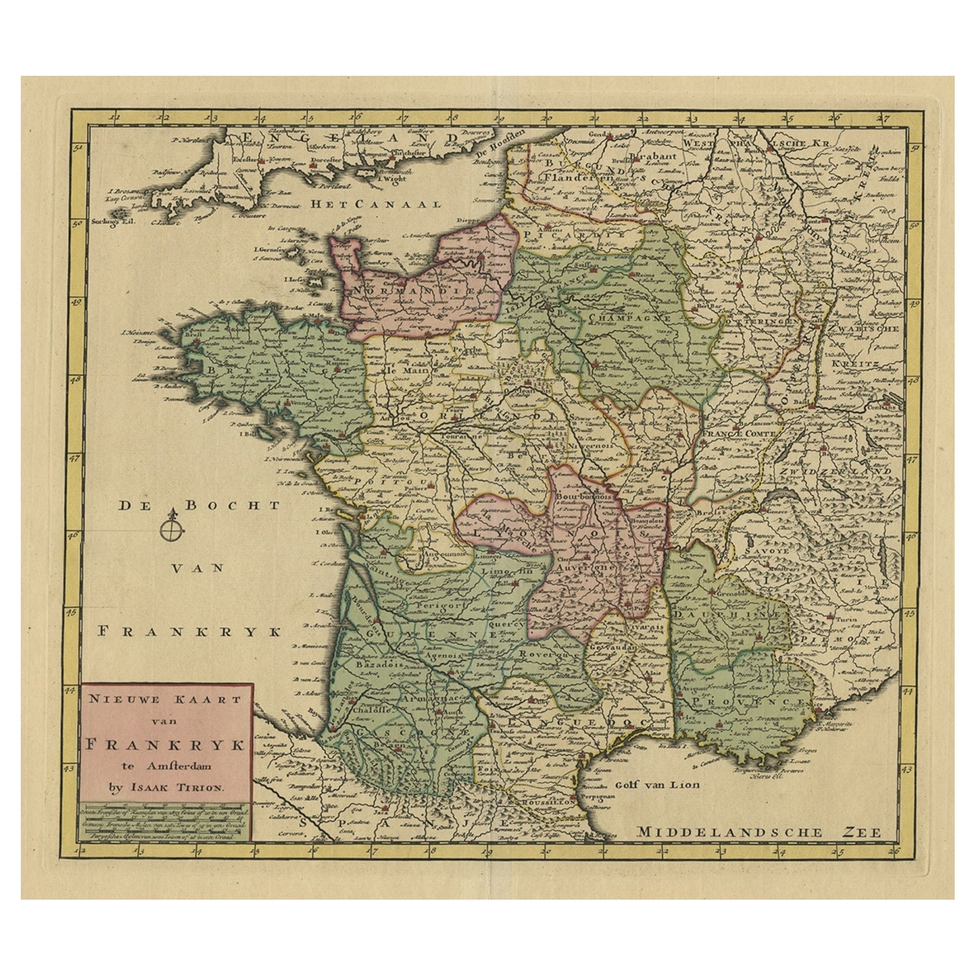
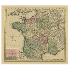
- Antique Map of France by Tirion, c.1740Located in Langweer, NLAntique map titled 'Nieuwe Kaart van Frankryk.' - Attractive detailed map showing France. Title in block-style cartouche with a simple compass rose. Source unknown, to be determined....Category
Antique 18th Century Maps
MaterialsPaper
You May Also Like
- 18th Century Emanuel Bowen Map of County of York, c.1740By Emanuel BowenLocated in Royal Tunbridge Wells, KentAntique 18th century British rare and original Emanuel Bowen (1694-1767) map of the County of York divided into its Ridings and subdivided into wapontakes, mounted in solid wood fram...Category
Antique Early 18th Century British Maps
MaterialsPaper
- 1844 Map "Russia in Eurpoe, Part II to Part VIII", 7 Maps Ric.r023Located in Norton, MA1844 Map "Russia in Eurpoe, Part II to Part VIII" 7 Maps Ric.r023 Fine, original, steel-engraved Map of Russia in Europe Part II t oPart VIII, by the Society for the Diffusion of Useful Knowledge. Detailed map of the regions to the northeast of Moscow. Including Arkhangel, Vologda, Viatka, Perm, Olonetz, Iaroslavl. The SDUK began its map publishing project under the leadership of Captain Francis Beaufort R.N. in 1829, and published the maps in parts, haltingly, over the next 15 years, completing the series in 1844, finally permitting the publication of a whole atlas. Many of the maps were actually drawn by Beaufort, who at the time was the Hydrographer to the Royal Navy, and all were closely supervised by him. J. & C. Walker worked closely with Beaufort in engraving the maps. Finely engraved, carefully researched, the maps set...Category
Antique 19th Century Unknown Maps
MaterialsPaper
- East German MapBy VEB Hermann HaackLocated in Baltimore, MDA brilliantly colourful map of the Leipzig, Karl Marx Stadt and Dresden area in the former German Democratic Republic by VEB Hermann Haack of Gotha.Category
Vintage 1970s German Maps
- Set of 4 Antique Geographical Maps French-German War 1870-71Located in Casale Monferrato, ITElegant late 19th century set of four antique geographical maps relating to the positioning of the armies in the Franco-German War 1870-71. A...Category
Antique 1890s Italian Maps
MaterialsPaper
- 1861 Topographical Map of the District of Columbia, by Boschke, Antique MapLocated in Colorado Springs, COPresented is an original map of Albert Boschke's extremely sought-after "Topographical Map of the District of Columbia Surveyed in the Years 1856 ...Category
Antique 1860s American Historical Memorabilia
MaterialsPaper
- 1907 Map of Colorado, Antique Topographical Map, by Louis NellLocated in Colorado Springs, COThis highly detailed pocket map is a topographical map of the state of Colorado by Louis Nell from 1907. The map "has been complied from all availabl...Category
Antique Early 1900s American Maps
MaterialsPaper


Recently Viewed
View AllMore Ways To Browse
Antique Furniture West London
Antique Cologne
German 18th C
Brunswick Antique
Antique German Decor
Antique London Map Print
Antique Furniture Brunswick
Hanover Furniture
West German Antiques
Salmon Plate
Hanover Used Furniture
C Moll
Hesse Antique
Herman Metal Prints
Antique Map Munster
Herman Hesse
Antique Surveying
Antique Style Map