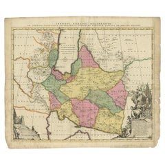
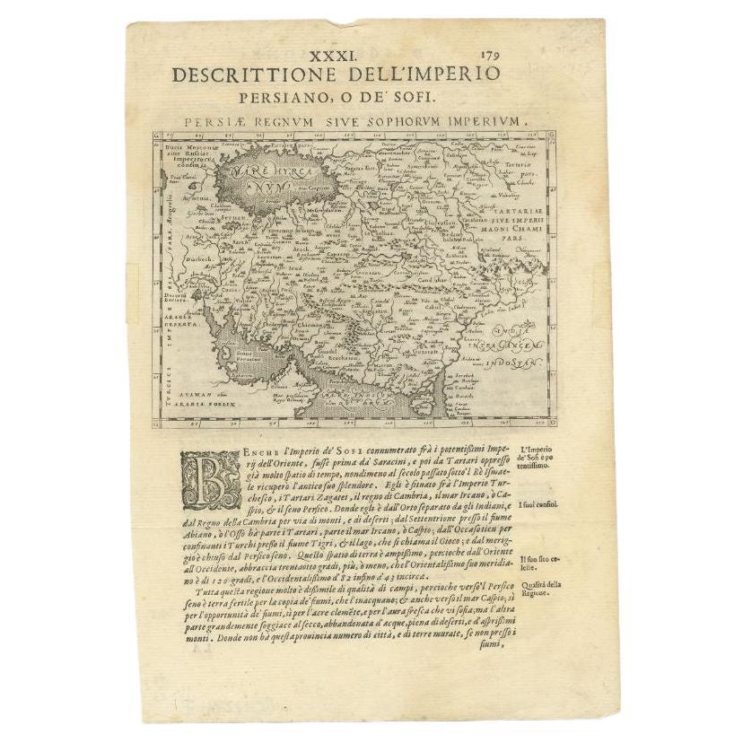
Antique Map of the Persian Empire by Schenk, 1705
View Similar Items


Want more images or videos?
Request additional images or videos from the seller
1 of 5
Antique Map of the Persian Empire by Schenk, 1705
About the Item
- Dimensions:Height: 20.67 in (52.5 cm)Width: 24.02 in (61 cm)Depth: 0 in (0.01 mm)
- Materials and Techniques:
- Period:
- Date of Manufacture:1705
- Condition:
- Seller Location:Langweer, NL
- Reference Number:Seller: BG-12233-31stDibs: LU3054327872482
About the Seller
5.0
Platinum Seller
These expertly vetted sellers are 1stDibs' most experienced sellers and are rated highest by our customers.
Established in 2009
1stDibs seller since 2017
1,933 sales on 1stDibs
More From This SellerView All
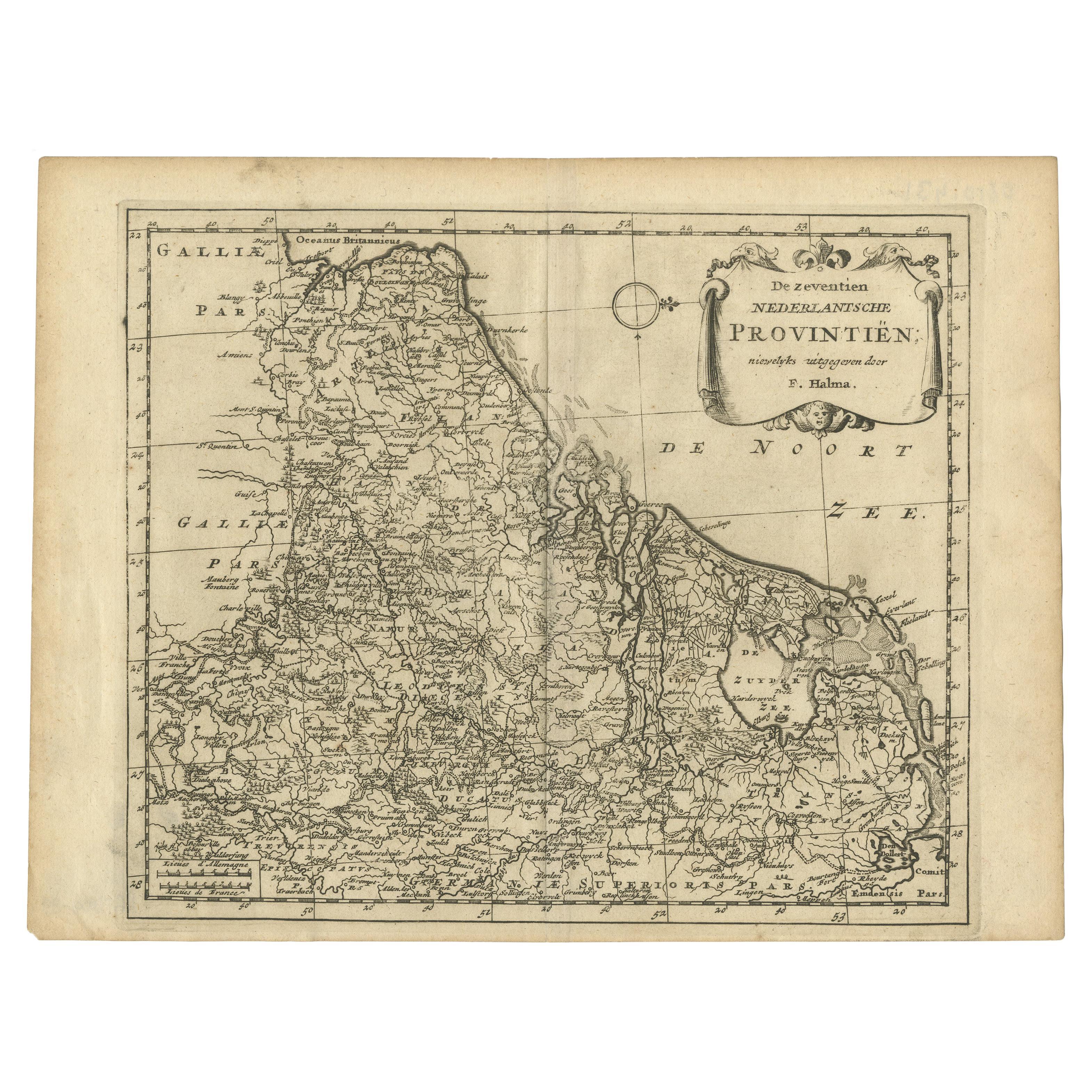
- Antique Map of the Seventeen Provinces by Halma '1705'Located in Langweer, NLAntique map titled 'De zeventien Nederlantsche Provintiën'. Original antique map of the Seventeen Provinces, the Imperial states of the Habsburg Netherlands in the 16th century. This...Category
Antique Early 18th Century Maps
MaterialsPaper
- Antique World Map by P. Schenk '1706'By Peter SchenkLocated in Langweer, NLAntique map titled 'Diversa Orbis Terrae. Visu Incedente per Coluros Tropicorum, Ambos Ejus Polos, et Parciularis Sphaerae Zenith, in Planum Orthographica Projectio (..) Plat Ontwerp van verscheyde Aert-klooten (..)'. One of the earliest Dutch World Maps to focus on a more modern cartographic style, based on Carel Allard's map of 1696. This map represented a noteworthy shift from the traditional decorative Dutch 17th century maps where the margins would be full of classical mythological...Category
Antique Early 18th Century Maps
MaterialsPaper
 $4,151 Sale Price30% Off
 - Antique Map of Portugal by P. Schenk, circa 1700Located in Langweer, NLAntique map titled 'Portugalliae et Algarbia'. Striking example of Schenk's rare map of Portugal, with the coats of arms of Portugal, Algarbia and a Spanish sailing vessell in the ca...Category
Antique Early 18th Century Maps
MaterialsPaper
 $713 Sale Price24% Off
 - Antique Map of Pomerania by Schenk, circa 1750Located in Langweer, NLThe "Ducatus Pomeraniae" is a historical map depicting the Duchy of Pomerania, a region that straddles the modern border between northeastern Germany and Poland. Crafted with ornamen...Category
Antique Mid-18th Century Maps
MaterialsPaper
- Antique Map of Russia by N. Sanson, 1705Located in Langweer, NLA strongly engraved map of European Russia showing its political divisions, major topographical features, cities and towns. Extends to the Sea of Azov and the tip of the Caspian Sea ...Category
Antique Early 18th Century Maps
MaterialsPaper
 $219 Sale Price33% Off
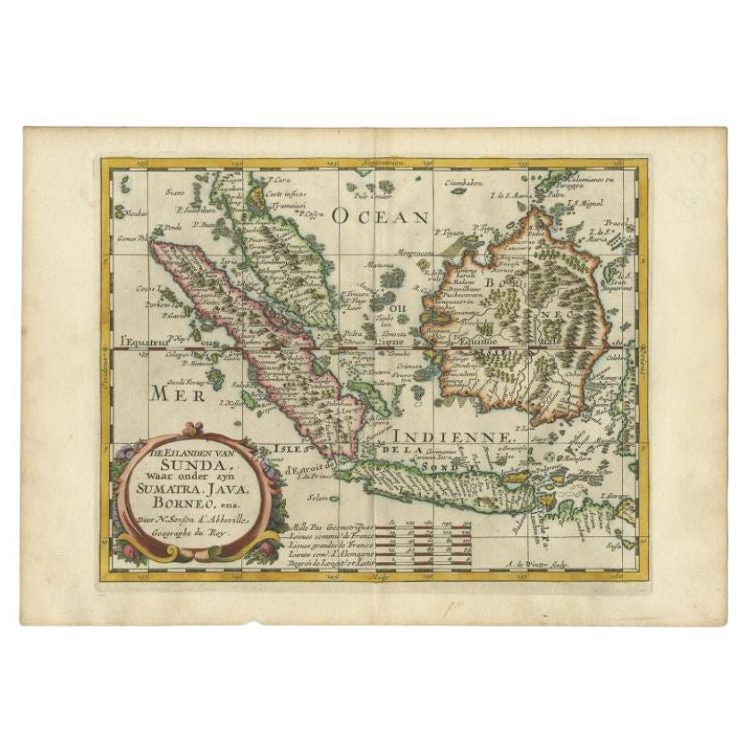
 - Antique Map of the Bangka Belitun Island by Sanson, 1705Located in Langweer, NLAntique map Sunda Islands titled 'De Eilanden van Sunda, waar onder zyn Sumatra, Java, Borneo enz'. Old map of the Bangka Belitun Islands, part of the Greater Sunda Islands, includin...Category
Antique 18th Century Maps
MaterialsPaper


You May Also Like
- 1861 Topographical Map of the District of Columbia, by Boschke, Antique MapLocated in Colorado Springs, COPresented is an original map of Albert Boschke's extremely sought-after "Topographical Map of the District of Columbia Surveyed in the Years 1856 ...Category
Antique 1860s American Historical Memorabilia
MaterialsPaper
- Super Rare Antique French Map of Chine and the Chinese Empire, 1780Located in Amsterdam, Noord HollandSuper Rare Antique French Map of Chine and the Chinese Empire, 1780 Very nice map of Asia. 1780 Made by Bonne. Additional information: Type: Map ...Category
Antique 18th Century European Maps
MaterialsPaper
- 1705 Golfe de Mexico and Florida Framed MapLocated in Stamford, CTFramed map of Mexico & Florida circa 1705, Paris. Small map with Mexico and the Gulf Coast. Inset text indicating Panama, Acapulco, Mexico City and the Mississippi. Extends North to ...Category
Antique Early 1700s French Spanish Colonial Maps
MaterialsGlass, Wood, Paper
- Antique Carte de L'Inde Myanmar, Malaysia Vietnam Map of Asia the Chinese EmpireLocated in Amsterdam, Noord HollandAntique Carte de L'Inde Myanmar, Malaysia Vietnam Map of Asia the Chinese Empire Very nice map of Asia. Additional information: Type: Map Country of Man...Category
Antique 18th Century European Maps
MaterialsPaper
 $584 Sale Price20% Off
 - Original Antique Map of The World by Thomas Clerk, 1817Located in St Annes, LancashireGreat map of The Eastern and Western Hemispheres On 2 sheets Copper-plate engraving Drawn and engraved by Thomas Clerk, Edinburgh. Published by Mackenzie And Dent, 1817 ...Category
Antique 1810s English Maps
MaterialsPaper
- 1907 Map of Colorado, Antique Topographical Map, by Louis NellLocated in Colorado Springs, COThis highly detailed pocket map is a topographical map of the state of Colorado by Louis Nell from 1907. The map "has been complied from all availabl...Category
Antique Early 1900s American Maps
MaterialsPaper


Recently Viewed
View AllMore Ways To Browse
For The Empire
Antique And Collectible Shop
Antique Paper Documents
Antique Base Empire Style
Antique Curiosity Shop
Engraving Empire
Antique Female Portrait
Dutch Empire
Antique Paper Stock
Dutch Empire Furniture
16th Century Style Portrait
Antique Persian Prints
Old Curiosity Shop
Modern Orientalist
Old Asia Map
Antique Map Art Collectibles
Antique Maps Art Collectibles
World Map Antique Style