Items Similar to Antique Map of the Phenomena of Volcanoes and Earthquakes by Reynolds, 1852


Want more images or videos?
Request additional images or videos from the seller
1 of 5
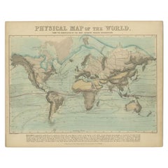
Antique Map of the Phenomena of Volcanoes and Earthquakes by Reynolds, 1852
About the Item
Antique world map showing the phenomena of Volcanoes and Earthquakes, showing the influence exerted by the heated interior of the earth upon its external surface. Originates from 'Geographical Diagrams '.
Artists and Engravers: Published by J. Reynolds, London.
Condition: Good, general age-related toning. Please study image carefully.
Date: 1850
Overall size: 28.5 x 22.7 cm.
Image size: 27 x 21 cm.
We sell original antique maps to collectors, historians, educators and interior decorators all over the world. Our collection includes a wide range of authentic antique maps from the 16th to the 20th centuries. Buying and collecting antique maps is a tradition that goes back hundreds of years. Antique maps have proved a richly rewarding investment over the past decade, thanks to a growing appreciation of their unique historical appeal. Today the decorative qualities of antique maps are widely recognized by interior designers who appreciate their beauty and design flexibility. Depending on the individual map, presentation, and context, a rare or antique map can be modern, traditional, abstract, figurative, serious or whimsical. We offer a wide range of authentic antique maps for any budget.
- Dimensions:Height: 8.94 in (22.7 cm)Width: 11.23 in (28.5 cm)Depth: 0 in (0.01 mm)
- Materials and Techniques:
- Period:
- Date of Manufacture:1852
- Condition:
- Seller Location:Langweer, NL
- Reference Number:
About the Seller
5.0
Platinum Seller
These expertly vetted sellers are 1stDibs' most experienced sellers and are rated highest by our customers.
Established in 2009
1stDibs seller since 2017
1,916 sales on 1stDibs
Typical response time: <1 hour
- ShippingRetrieving quote...Ships From: Langweer, Netherlands
- Return PolicyA return for this item may be initiated within 14 days of delivery.
More From This SellerView All
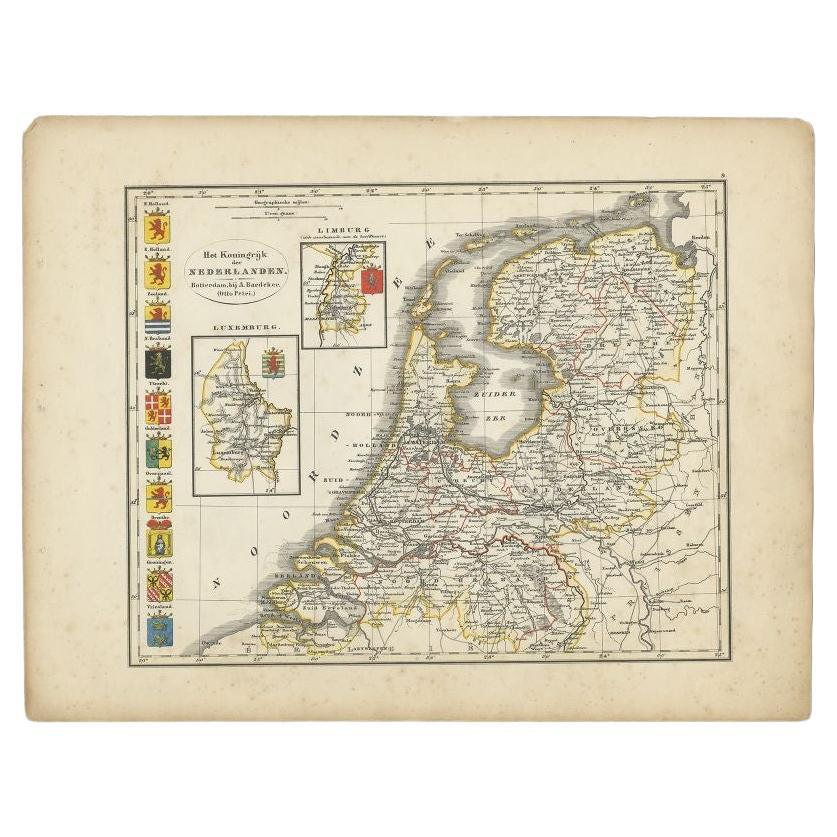
- Antique Map of the Netherlands by Petri, 1852Located in Langweer, NLAntique map titled 'Het Koninkrijk der Nederlanden'. Map of the Netherlands, with coats of arms of all Dutch provinces. Also includes a small inset map of Luxembourg...Category
Antique 19th Century Maps
MaterialsPaper
- Antique Map of the Bosporus and Dardanelles, 1852Located in Langweer, NLAntique map titled 'The Bosphorus and Dardanelles'. Original map of the Bosphorus and Dardanelles. This map originates from 'Lowry's Table Atlas constructed and engraved from the mos...Category
Antique Mid-19th Century Maps
MaterialsPaper
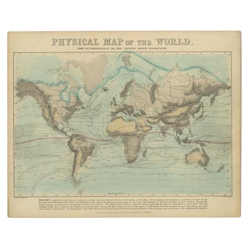
- Antique Physical Map of the World by Reynolds, 1849Located in Langweer, NLAntique physical map of the world, showing the discoveries of the most eminent modern geographers. Originates from 'Geographical Diagrams '. Artists and Engravers: Published by J...Category
Antique 19th Century Maps
MaterialsPaper
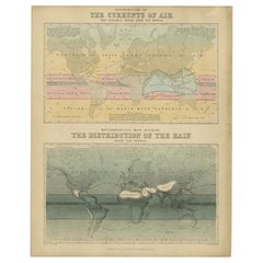
- Antique Map of the Distribution of Air and Rain by Reynolds, 1843Located in Langweer, NLTwo antique world maps on one sheet. The upper map shows the distribution of the currents of air and variable winds over the world. The lower meteorological map shows the distributio...Category
Antique 19th Century Maps
MaterialsPaper
- Antique Map of the Northern Hemisphere by Lowry, '1852'Located in Langweer, NLAntique map titled 'Perspective Projection of the World on the horizon of London'. Original map of the northern hemisphere. This map originates fro...Category
Antique Mid-19th Century Maps
MaterialsPaper
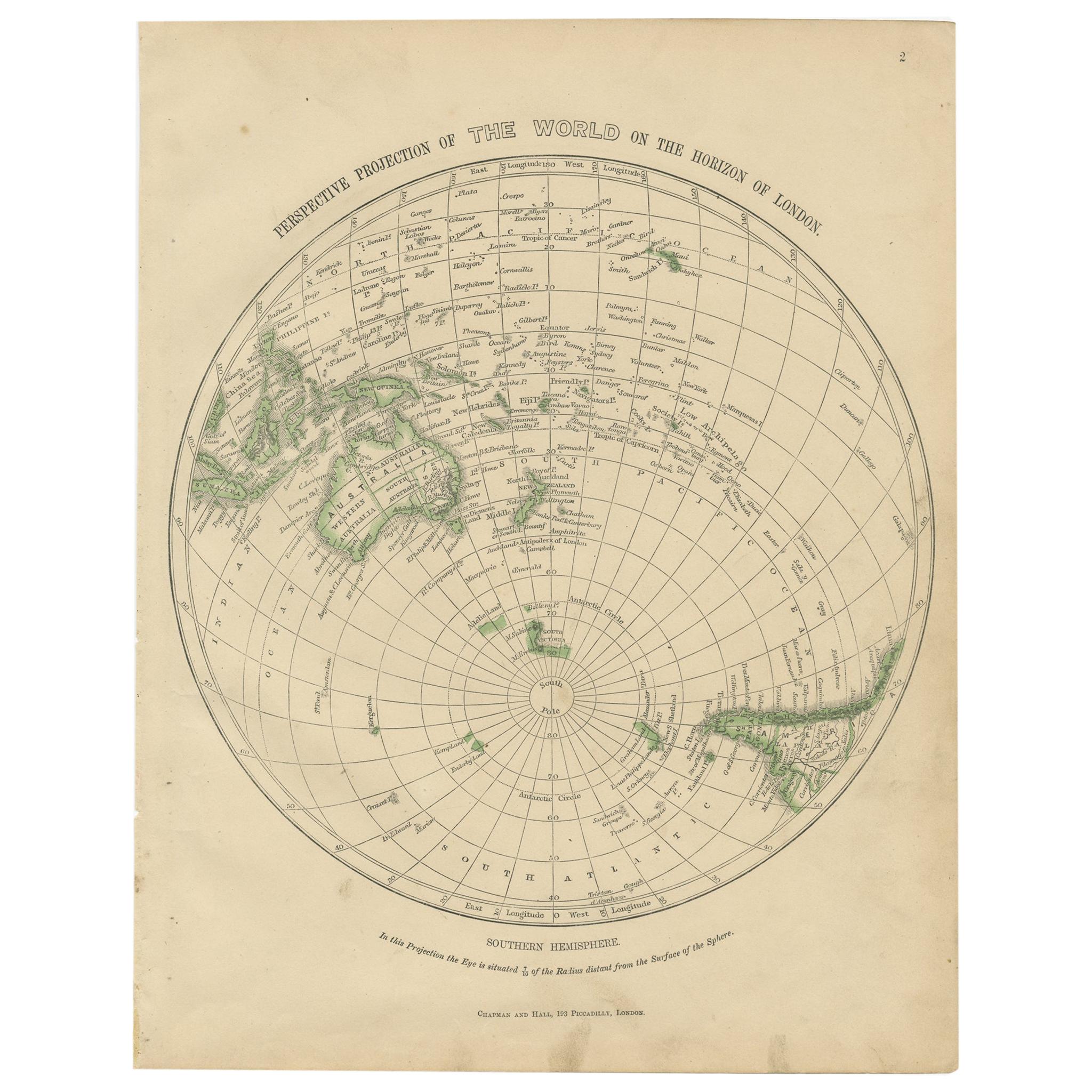
- Antique Map of the Southern Hemipshere by Lowry '1852'Located in Langweer, NLAntique map titled 'Perspective Projection of The World on the horizon of London'. Original map of the southern hemisphere. This map originates from 'Lowry's Table Atlas constructe...Category
Antique Mid-19th Century Maps
MaterialsPaper


You May Also Like
- 1861 Topographical Map of the District of Columbia, by Boschke, Antique MapLocated in Colorado Springs, COPresented is an original map of Albert Boschke's extremely sought-after "Topographical Map of the District of Columbia Surveyed in the Years 1856 ...Category
Antique 1860s American Historical Memorabilia
MaterialsPaper
- Large1852 Map "Russian Empire" Ric.r0011Located in Norton, MALarge 1852 map "Russian Empire" George Phillips & Son 1852 Ric.r0011 Dimension: Paper: 67 cm W x 52 cm H ; Sight: 60cm W x 50 cm H Condition: Good Condition with aged tonin...Category
Antique 19th Century Unknown Maps
MaterialsPaper
- 1907 Map of Colorado, Antique Topographical Map, by Louis NellLocated in Colorado Springs, COThis highly detailed pocket map is a topographical map of the state of Colorado by Louis Nell from 1907. The map "has been complied from all availabl...Category
Antique Early 1900s American Maps
MaterialsPaper
- Original Antique Map of The Netherlands, Engraved by Barlow, Dated 1807Located in St Annes, LancashireGreat map of Netherlands Copper-plate engraving by Barlow Published by Brightly & Kinnersly, Bungay, Suffolk. Dated 1807 Unframed.Category
Antique Early 1800s English Maps
MaterialsPaper
- 1854 Map of Massachusetts, Connecticut and Rhode Island, Antique Wall MapLocated in Colorado Springs, COThis striking wall map was published in 1854 by Ensign, Bridgman & Fanning and has both full original hand-coloring and original hardware. This impression is both informative and highly decorative. The states are divided into counties, outlined in red, green, and black, and subdivided into towns. Roads, canals, and railroad lines are prominently depicted, although they are not all labeled. The mapmakers also marked lighthouses, banks, churches, and prominent buildings, with a key at right. The map is an informative and comprehensive overview of the infrastructural development of New England prior to the Civil War. Physical geographies depicted include elevation, conveyed with hachure marks, rivers and lakes. The impression features an inset map of Boston...Category
Antique 19th Century American Maps
MaterialsPaper
- Original Antique Map of the American State of Nevada, 1889Located in St Annes, LancashireGreat map of Nevada Drawn and Engraved by W. & A.K. Johnston Published By A & C Black, Edinburgh. Original colour Unframed.Category
Antique 1880s Scottish Victorian Maps
MaterialsPaper


Recently Viewed
View AllMore Ways To Browse
Diagram Map
Antique Earthquake
Antique Diagrams
Antique Australian Maps
Antique Map Of Australia
Antique Australian Map
Antique Furniture In The Philippines
Large Framed Antique Maps
Antique Filipino
Antique Map Japan
Political Map
Antique Baltic
Ireland Map
Irish Map
Map Of Ireland
Captain Cook
Large Antique City Maps
Norwegian Antiques