Items Similar to Antique Map Showing Estates of 1669 in Amsterdam, Published in c.1767
Want more images or videos?
Request additional images or videos from the seller
1 of 5
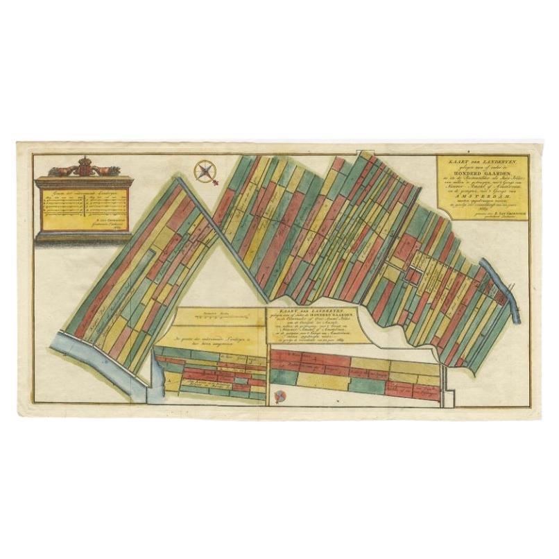
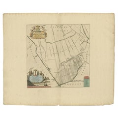
Antique Map Showing Estates of 1669 in Amsterdam, Published in c.1767
$236.21
$295.2620% Off
£176.99
£221.2420% Off
€200
€25020% Off
CA$331.66
CA$414.5820% Off
A$363.49
A$454.3720% Off
CHF 189.82
CHF 237.2820% Off
MX$4,361.50
MX$5,451.8720% Off
NOK 2,383.55
NOK 2,979.4420% Off
SEK 2,245.22
SEK 2,806.5220% Off
DKK 1,523.36
DKK 1,904.2020% Off
About the Item
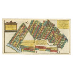
Antique map titled 'Kaart der landeryen, gelegen aan of onder de honderd gaarden, zo in de Buitenvelder- als Stads-polder; van welken de gestreepten, voor 't geregt van Nieuwer-Amstel of Amsterveen, en de gestipten, voor 't geregt van Amsterdam, moeten opgedraagen worden, in gevolge der overeenkomst van den jaare 1669, gemeeten door B. van Groendyck, geadmitteerd landmeeter'. Map showing estates in Amsterdam in 1669. Published by Yntema and Tieboel, 1767
Artists and Engravers: Anonymous.
Condition: Good, general age-related toning. Original folding lines. Minor wear, blank verso. Please study image carefully.
Date: c.1767
Overall size: 63 x 43 cm.
Image size: 58 x 29 cm.
- Dimensions:Height: 16.93 in (43 cm)Width: 24.81 in (63 cm)Depth: 0 in (0.01 mm)
- Materials and Techniques:
- Period:
- Date of Manufacture:circa 1767
- Condition:
- Seller Location:Langweer, NL
- Reference Number:Seller: BV-00741stDibs: LU3054326221212
About the Seller
5.0
Recognized Seller
These prestigious sellers are industry leaders and represent the highest echelon for item quality and design.
Platinum Seller
Premium sellers with a 4.7+ rating and 24-hour response times
Established in 2009
1stDibs seller since 2017
2,670 sales on 1stDibs
Typical response time: <1 hour
- ShippingRetrieving quote...Shipping from: Langweer, Netherlands
- Return Policy
Authenticity Guarantee
In the unlikely event there’s an issue with an item’s authenticity, contact us within 1 year for a full refund. DetailsMoney-Back Guarantee
If your item is not as described, is damaged in transit, or does not arrive, contact us within 7 days for a full refund. Details24-Hour Cancellation
You have a 24-hour grace period in which to reconsider your purchase, with no questions asked.Vetted Professional Sellers
Our world-class sellers must adhere to strict standards for service and quality, maintaining the integrity of our listings.Price-Match Guarantee
If you find that a seller listed the same item for a lower price elsewhere, we’ll match it.Trusted Global Delivery
Our best-in-class carrier network provides specialized shipping options worldwide, including custom delivery.More From This Seller
View AllAntique Map Showing Estates of 1669 in Amsterdam, Published in c.1767
Located in Langweer, NL
Antique map titled 'Kaart der landeryen, gelegen aan of onder de honderd gaarden, zo in de Buitenvelder- als Stads-polder; van welken de gestreepten, voor 't geregt van Nieuwer-Amste...
Category
Antique 18th Century Maps
Materials
Paper
$425 Sale Price
20% Off
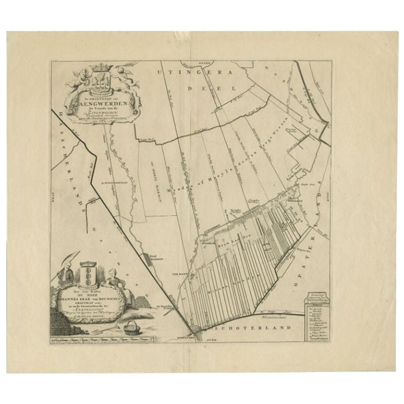
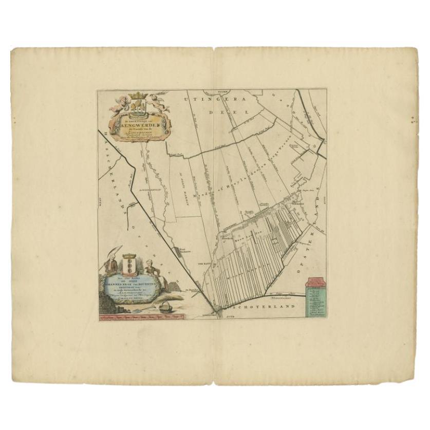
Antique Map of the Aengwirden Township, Friesland, the Netherlands, 1718
Located in Langweer, NL
Antique map titled 'De Grietenije van Aengwerden, de Tweede van de Zevenwolden (..)'. Old map of Friesland, the Netherlands. This map depicts the region of Aengwirden and includes ci...
Category
Antique 18th Century Maps
Materials
Paper
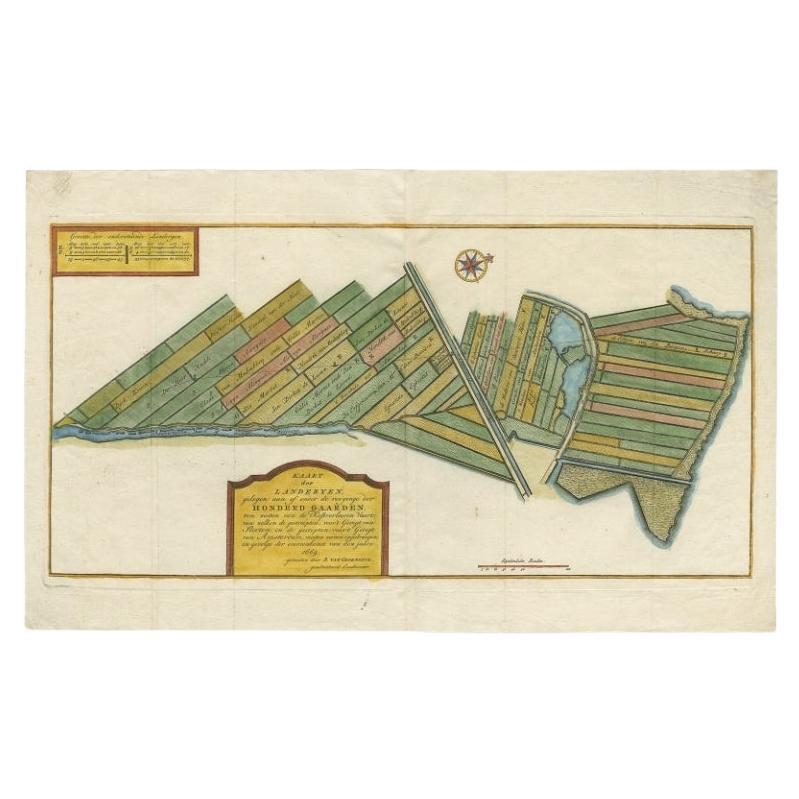
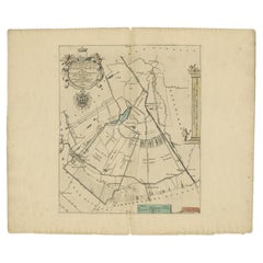
Antique Map of Estates of The Year 1669 in Amsterdam, Published c.1767
Located in Langweer, NL
Antique map titled 'Kaart der Landerijen, gelegen aan of onder de rooyinge der honderd gaarden (..)'. Map showing estates in Amsterdam in 1669. Published by Yntema and Tieboel, 1767....
Category
Antique 18th Century Maps
Materials
Paper

$330 Sale Price
20% Off
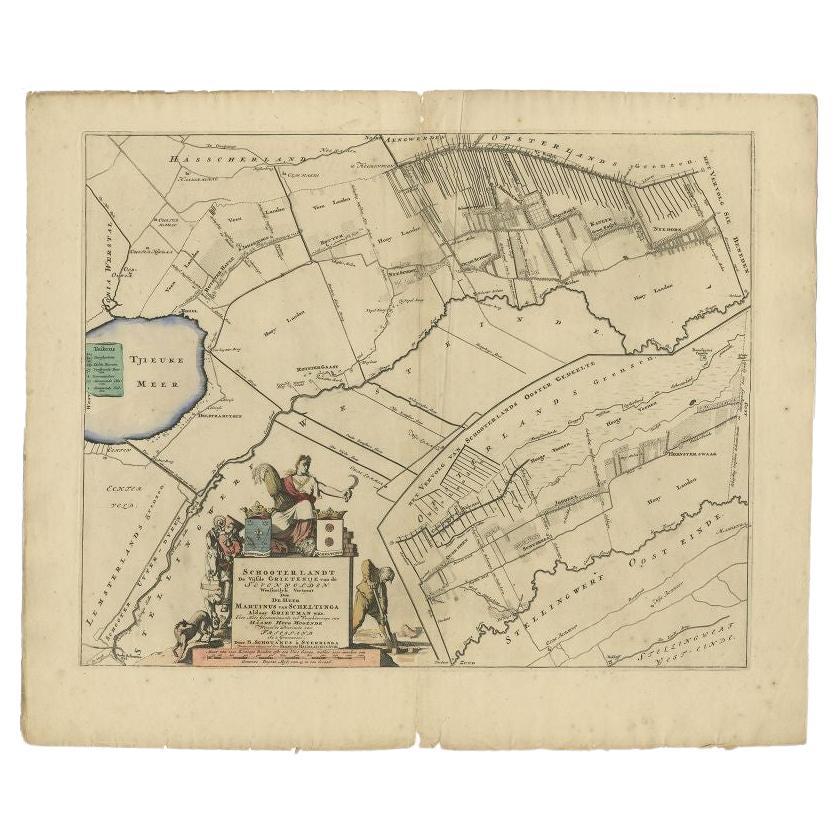
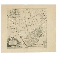
Antique Map of the Schoterland Township, Friesland by Halma, 1718
Located in Langweer, NL
Antique map Friesland titled 'Schooterlandt de Vijfde Grietenije van de Sevenwolden (..)'. Old map of Friesland, the Netherlands. This map depicts the region of Schoterland and inclu...
Category
Antique 18th Century Maps
Materials
Paper

$316 Sale Price
20% Off
Antique Map of the Aengwirden Township 'Friesland' by Halma, 1718
Located in Langweer, NL
Antique map titled 'De Grietenije van Aengwerden, de Tweede van de Zevenwolden (..)'. Old map of Friesland, the Netherlands. This map depicts the region of Aengwirden and includes ci...
Category
Antique 18th Century Maps
Materials
Paper
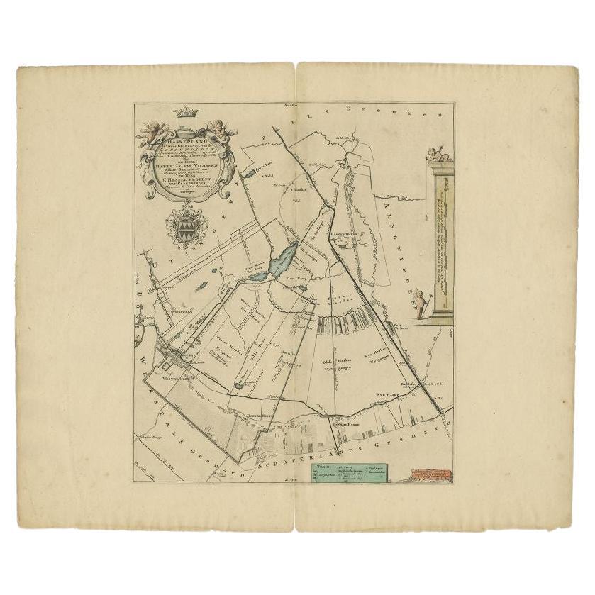
Antique Map of the Haskerland Township 'Friesland' by Halma, 1718
Located in Langweer, NL
Antique map Friesland titled 'Haskerland, de vierde Grietenije van de Zevenwolden (..)'. Old map of Friesland, the Netherlands. This map depicts the region of Haskerland and includes...
Category
Antique 18th Century Maps
Materials
Paper
$335 Sale Price
20% Off
You May Also Like
1748 Map of Richmond Upon Thames by John Roque
Located in Gloucestershire, GB
A 1748 map of Richmond-Upon-Thames by famed surveyor and cartographer, John Roque. Placed in a simple black and gilt frame. The map is in fair condition but there are small sections ...
Category
Antique Mid-18th Century English Maps
Materials
Wood, Paper

Original Antique Map or City Plan of Amsterdam, Netherlands. Circa 1835
Located in St Annes, Lancashire
Nice map of Amsterdam
Drawn and engraved by J.Dower
Published by Orr & Smith. C.1835
Unframed.
Free shipping
Category
Antique 1830s English Maps
Materials
Paper

1752 Vaugoundy Map of Flanders : Belgium, France, and the Netherlands, Ric.a002
Located in Norton, MA
Large Vaugoundy Map of Flanders:
Belgium, France, and the Netherlands
Colored -1752
Ric.a002
Description: This is a 1752 Didier Robert de Vaugondy map of Flanders. The map de...
Category
Antique 17th Century Unknown Maps
Materials
Paper

Large Original Antique Folding Map of Manchester, England, Dated 1793
Located in St Annes, Lancashire
Superb map of Manchester and Salford
Folding map. Printed on paper laid on to the original canvas
Unframed.
Published by C. Laurent, 1793.
Free shippi...
Category
Antique 1790s English Georgian Maps
Materials
Canvas, Paper

1657 Janssonius Map of Vermandois and Cappelle, Ric. A-004
Located in Norton, MA
1657 Janssonius map of
Vermandois and Cappelle
Ric.a004
Description: Antique map of France titled 'Descriptio Veromanduorum - Gouvernement de la Cappelle'. Two detailed maps o...
Category
Antique 17th Century Unknown Maps
Materials
Paper

Mid-18th Century Hand Drawn English Farm Map on Vellum, circa 1740s
Located in San Francisco, CA
Mid-18th century hand drawn English farm map on Vellum circa 1740s
Henry Maxted & Isaac Terry, Surveyors.
A Map of a Farm in the Parish of Blean in the County of KENT: Belonging to Mrs Elizabeth Hodgson circa 1743.
A beautiful hand drawn map...
Category
Antique Mid-18th Century English Maps
Materials
Lambskin

More Ways To Browse
Antique Nautical Maps
Sri Lanka Map
Hand Painted Antique Map
Ottoman Map
Philippines Map
Roman Empire Map
Sebastian Munster
South African Antique
Antique Sri Lanka Map
Maps Balkans
Antique Map Of Jerusalem
Map Of Corsica
Solomons Temple
Antique Map Of Korea
Map Of Jerusalem
Prussia Map
Antique Maps Caribbean Islands
Antique Wine Maps