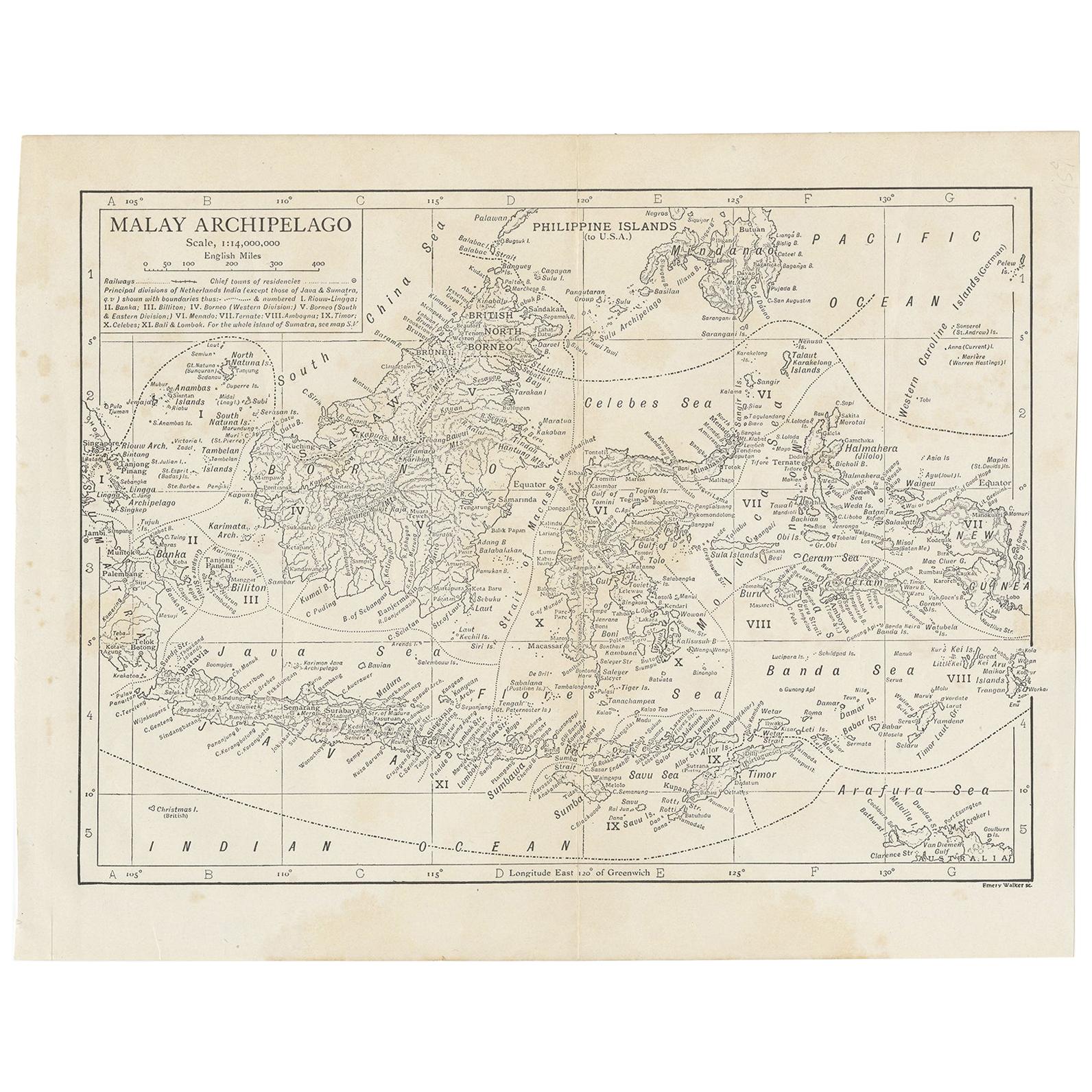
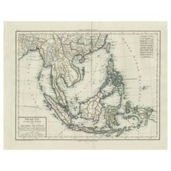
Antique Map of Siam, Java and the Malay Archipelago, 1895
View Similar Items


Want more images or videos?
Request additional images or videos from the seller
1 of 2
Antique Map of Siam, Java and the Malay Archipelago, 1895
About the Item
- Dimensions:Height: 10.52 in (26.7 cm)Width: 16.26 in (41.3 cm)Depth: 0.02 in (0.5 mm)
- Period:
- Date of Manufacture:1895
- Condition:Please study image carefully.
- Seller Location:Langweer, NL
- Reference Number:Seller: D-04531stDibs: LU305439809231
About the Seller
5.0
Platinum Seller
These expertly vetted sellers are 1stDibs' most experienced sellers and are rated highest by our customers.
Established in 2009
1stDibs seller since 2017
1,950 sales on 1stDibs
More From This SellerView All
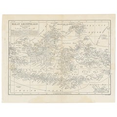
- Antique Map of the Malay Archipelago by Walker, 1911Located in Langweer, NLAntique map titled 'Malay Archipelago'. Old map of the Malay Archipelago including Borneo, Celebes, New Guinea, Java, Timor and others. This map ...Category
Early 20th Century Maps
MaterialsPaper
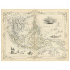
- Antique Map of the Malay Archipelago with Images of Indigenous People, 1851Located in Langweer, NLJohn Tallis & Company, often simply known as Tallis, was renowned for the production of maps and illustrated geographical publications in the mid-19th century. Tallis maps, such as t...Category
Antique 1850s Maps
MaterialsPaper
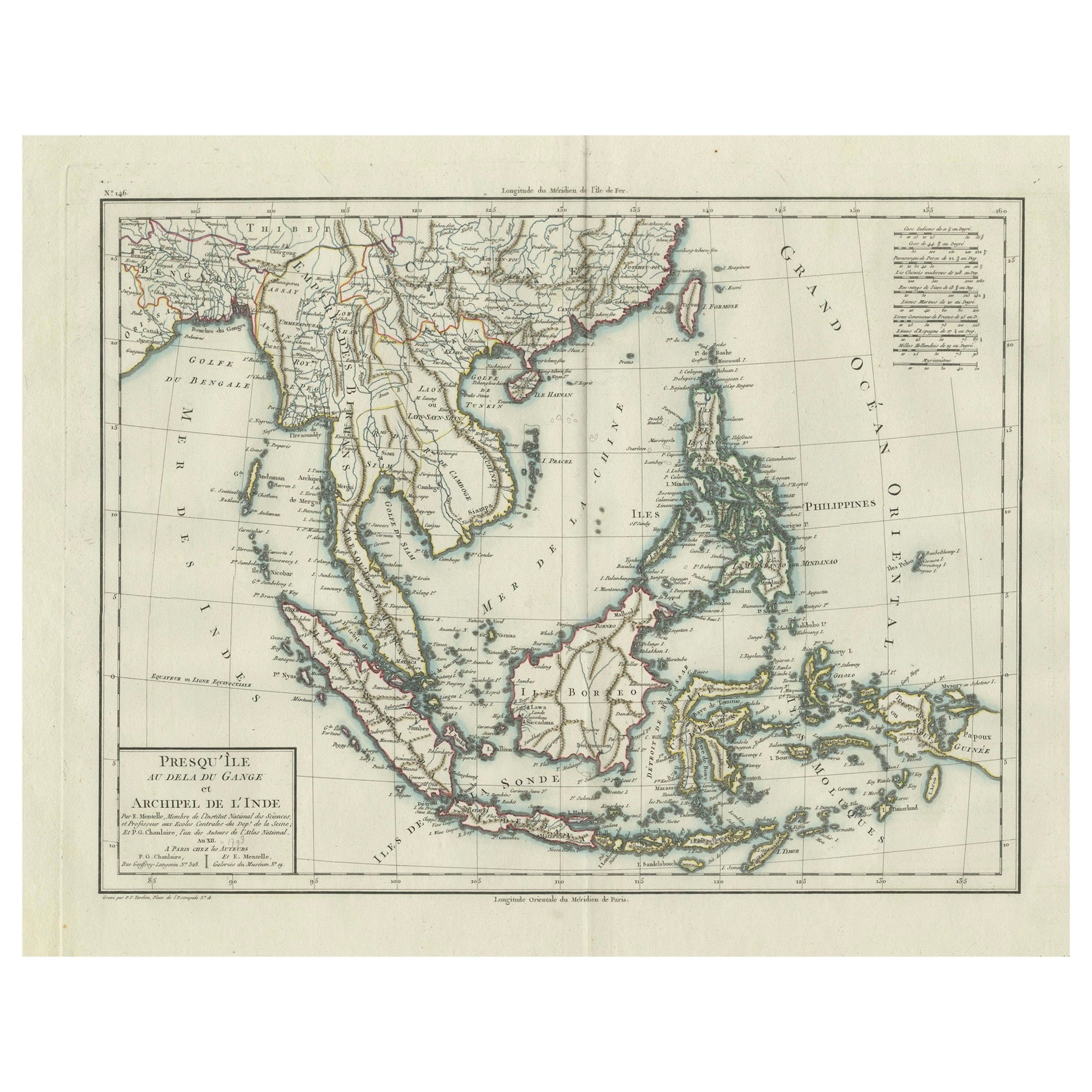
- 1797 Tardieu Map of Southeast Asia: The Malay Archipelago and BeyondLocated in Langweer, NLAn original historical map titled 'Presqu' Île Au Dela Du Gange et Archipel De L'Inde', created by Pierre Francois Tardieu and published in the "Atlas Universel" by Pierre Grégoire C...Category
Antique 1790s Maps
MaterialsPaper
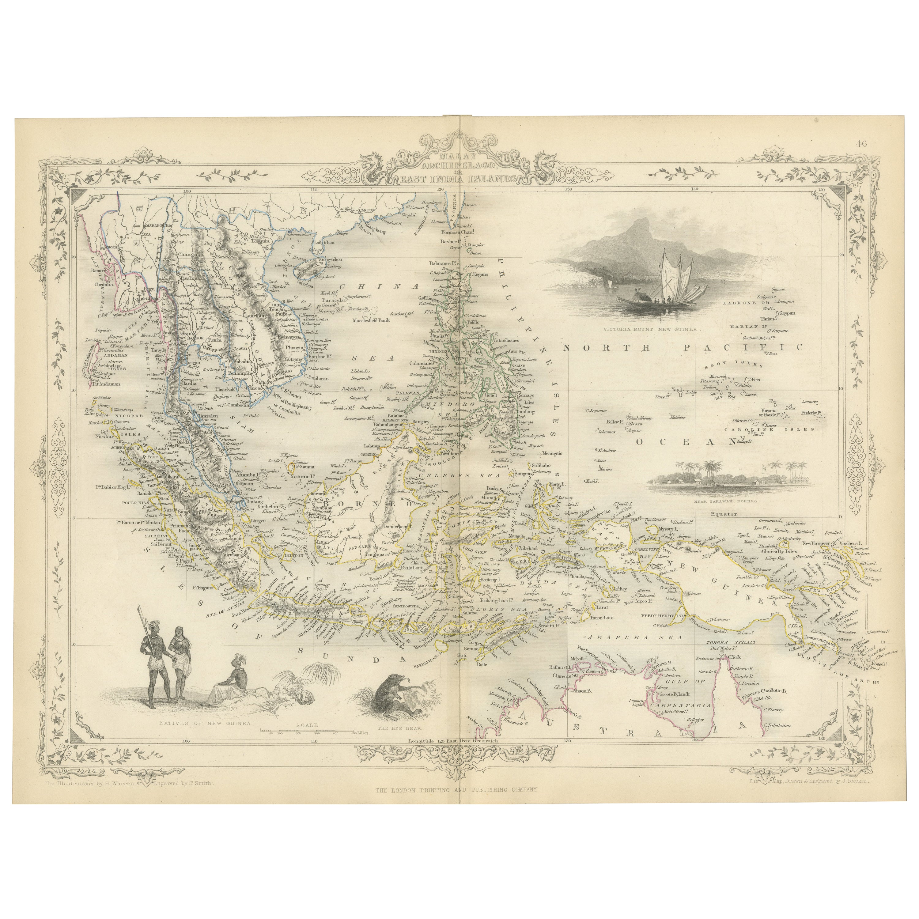
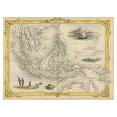
- Decorative Antique Map of the Malay Archipelago or East Indies Island, 1851Located in Langweer, NLAntique map Indonesia titled 'Malay Archipelago, or East India Islands'. With vignettes of Victoria Mount, New Guinea, Nativaes of New Guinea an...Category
Antique 1850s Maps
MaterialsPaper
- Antique Map of the Sunda Islands Sumatra, Java, Malay Peninsula & Borneo (1739)By Isaak TirionLocated in Langweer, NLAntique map titled 'Nieuwe kaart van de Sundasche Eilanden als Borneo, Sumatra en Groot Iava & c'. Detailed map of the Sunda Islands, Southeast Asia, extending from the tip of Cambod...Category
Antique Mid-18th Century Maps
MaterialsPaper
 $649 Sale Price21% Off
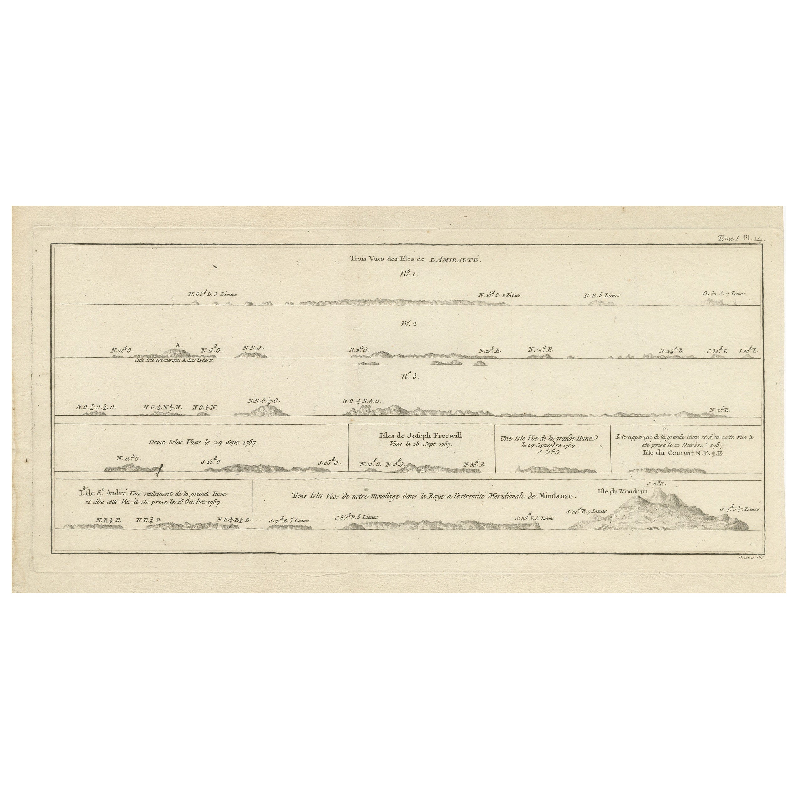
 - Antique Map of the Admiralty Islands, Bismarck ArchipelagoLocated in Langweer, NLAntique map titled 'Trois Vues des Isles de l'Amirauté'. Several coastal views of the Admiralty Islands, Bismarck Archipelago, to the north of New Guinea in the South Pacific Ocean. ...Category
Antique Late 18th Century Maps
MaterialsPaper

You May Also Like
- Large Original Antique Map of Java and Borneo, Fullarton, C.1870Located in St Annes, LancashireGreat map of Java and Borneo Wonderful figurative borders From the celebrated Royal Illustrated Atlas Lithograph. Original color. Published by Fullarton, Edinburgh. C.1870 Unfr...Category
Antique 1870s Scottish Maps
MaterialsPaper
- Living in Paradise At Home in the Tropics Bali, Java, ThailandBy Rizzoli International PublicationsLocated in New York, NYLiving in Paradise brims with the best of tropical residential designs. Architecture and interior design experts Annie Kelly and Tim Street-Porter have selected unique interiors that will inspire readers to create their own paradises. The stunning venues in lush settings profiled here range in style from the environmentally sustainable utilizing indigenous materials, such as thatching and bamboo, to breezy courtyard spaces. These homes take into account the dramatic natural landscapes--some are surrounded by tropical plantings, while others open onto dramatic sun-drenched beaches. The interiors incorporate organic textures such as cane and bamboo furnishings, some covered in exotic Indonesian fabrics...Category
21st Century and Contemporary American Books
MaterialsPaper
- 1861 Topographical Map of the District of Columbia, by Boschke, Antique MapLocated in Colorado Springs, COPresented is an original map of Albert Boschke's extremely sought-after "Topographical Map of the District of Columbia Surveyed in the Years 1856 ...Category
Antique 1860s American Historical Memorabilia
MaterialsPaper
- Original Antique Map of the American State of Pennsylvania, 1889Located in St Annes, LancashireGreat map of Pennsylvania Drawn and Engraved by W. & A.K. Johnston Published By A & C Black, Edinburgh. Original colour Unframed. Repair to a minor tear on bottom edge.Category
Antique 1880s Scottish Victorian Maps
MaterialsPaper
- Original Antique Map of the American State of Nevada, 1889Located in St Annes, LancashireGreat map of Nevada Drawn and Engraved by W. & A.K. Johnston Published By A & C Black, Edinburgh. Original colour Unframed.Category
Antique 1880s Scottish Victorian Maps
MaterialsPaper
- Original Antique Map of the American State of Washington, 1889Located in St Annes, LancashireGreat map of Washington Drawn and Engraved by W. & A.K. Johnston Published By A & C Black, Edinburgh. Original colour Unframed.Category
Antique 1880s Scottish Victorian Maps
MaterialsPaper


Recently Viewed
View AllMore Ways To Browse
Malay Archipelago Map
Antique Map Of Southeastern Us
Malay Archipelago Map
Fiji Map
Map Of Lebanon
Bad Bentheim
English County Maps By Blaeu
Wenceslas Hollar
Astrological Map
Astrology Map
Old Cypriot Maps
Tanzania Antique Map
Cincinnati Map
Giovanni Maria Cassini On Sale
Poired Metal
Antique Map Austro Hungarian
Antique Cabbage Cutter
Brinkman Co