Items Similar to Antique Map of South America by Scherer, c.1700
Want more images or videos?
Request additional images or videos from the seller
1 of 5
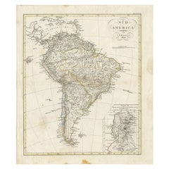
Antique Map of South America by Scherer, c.1700
About the Item
Antique map of part of South America. Two maps on a single sheet, each depicting nearly the same area. On close examination there are slight differences in the rivers, lakes and mountain ranges. Major cities are located including the mythical Dorado. Source unknown, to be determined. Artists and Engravers: Heinrich Scherer (1628-1704) was a Professor of Hebrew, Mathematics and Ethics at the University of Dillingen until about 1680. Thereafter he obtained important positions as Official Tutor to the Royal Princes of Mantua and Bavaria. It was during his time in Munich as Tutor to the Princely house of Bavaria that his lifetime?s work as a cartographer received acclaim and recognition. Scherer?s world atlas, the Atlas Novus, first published in Munich between 1702 and 1710 and reissued in a second edition between 1730 and 1737, forms a singularly unusual, almost revolutionary work in terms of the development of European mapmaking at the beginning of the 18th Century.
Artist: Heinrich Scherer (1628-1704) was a Professor of Hebrew, Mathematics and Ethics at the University of Dillingen until about 1680. Thereafter he obtained important positions as Official Tutor to the Royal Princes of Mantua and Bavaria. It was during his time in Munich as Tutor to the Princely house of Bavaria that his lifetime?s work as a cartographer received acclaim and recognition. Scherer?s world atlas, the Atlas Novus, first published in Munich between 1702 and 1710 and reissued in a second edition between 1730 and 1737, forms a singularly unusual, almost revolutionary work in terms of the development of European mapmaking at the beginning of the 18th Century.
Condition: Good, given age. Minor crease right edge. General age-related toning and/or occasional minor defects from handling. Please study image carefully.
Date: c.1700
Overall size: 21 x 27 cm.
Image size: 0.001 x 18.3 x 23.5 cm.
Antique prints have long been appreciated for both their aesthetic and investment value. They were the product of engraved, etched or lithographed plates. These plates were handmade out of wood or metal, which required an incredible level of skill, patience and craftsmanship. Whether you have a house with Victorian furniture or more contemporary decor an old engraving can enhance your living space.
- Creator:Thomas Kitchin (Author)
- Dimensions:Height: 10.63 in (27 cm)Width: 8.27 in (21 cm)Depth: 0 in (0.01 mm)
- Materials and Techniques:
- Period:
- Date of Manufacture:circa 1700
- Condition:
- Seller Location:Langweer, NL
- Reference Number:
About the Seller
5.0
Platinum Seller
These expertly vetted sellers are 1stDibs' most experienced sellers and are rated highest by our customers.
Established in 2009
1stDibs seller since 2017
1,916 sales on 1stDibs
Typical response time: <1 hour
- ShippingRetrieving quote...Ships From: Langweer, Netherlands
- Return PolicyA return for this item may be initiated within 14 days of delivery.
More From This SellerView All
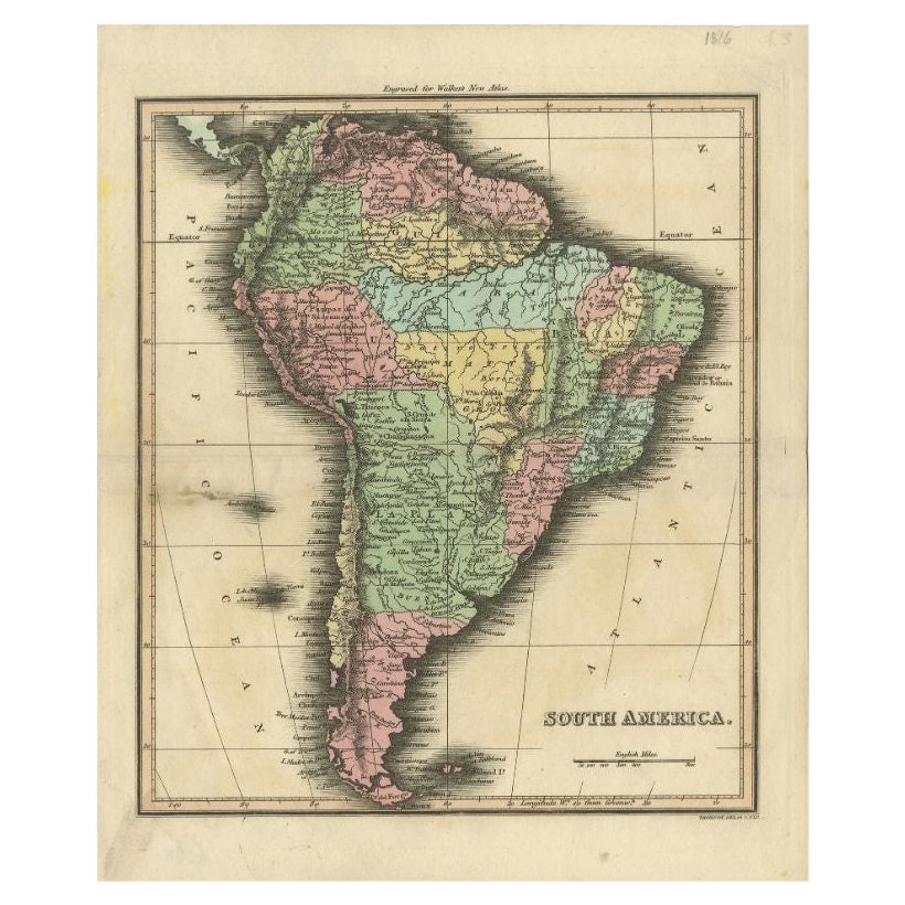
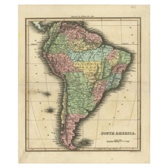
- Antique Map of South America by Walker, 1816By Thomas KitchinLocated in Langweer, NLAntique map titled 'South America'. Old map of South America. This map originates from 'Walker's Universal Atlas'. Artists and Engravers: Printed by Barnard and Farley. Artist: Pr...Category
Antique 19th Century Maps
MaterialsPaper
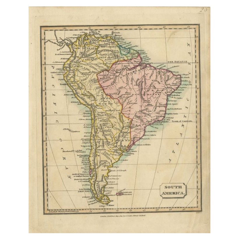
- Antique Map of South America by Tyrer, 1821By Thomas KitchinLocated in Langweer, NLAntique map titled 'South America'. Beautiful antique map of South America engraved by Tyrer. Artists and Engravers: Published by J. Soute...Category
Antique 19th Century Maps
MaterialsPaper
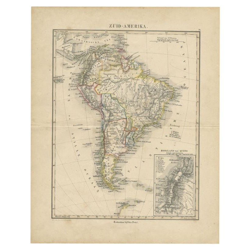
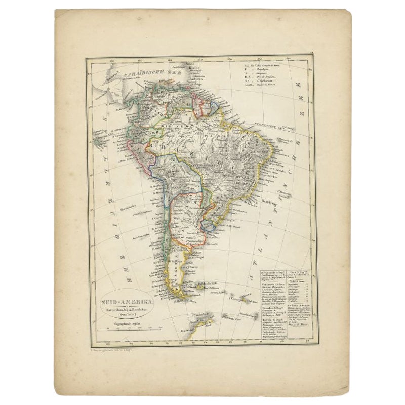
- Antique Map of South America by Petri, c.1873By Thomas KitchinLocated in Langweer, NLAntique map titled 'Zuid-Amerika'. Old map depicting South America, with an inset map of the highland of Quito. This map originates from 'School-Atlas van alle Deelen der Aarde'. Art...Category
Antique 19th Century Maps
MaterialsPaper
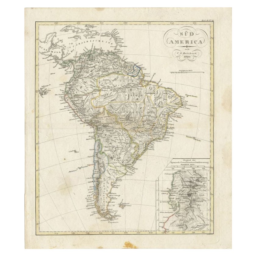
- Antique Map of South America by Reichard, 1820By Thomas KitchinLocated in Langweer, NLAntique map titled 'Süd America'. Decorative antique map of South America with an inset map of Ecuador. Artists and Engravers: Published b...Category
Antique 19th Century Maps
MaterialsPaper
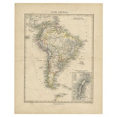
- Antique Map of South America by Petri, 1852By Thomas KitchinLocated in Langweer, NLAntique map titled 'Zuid-Amerika'. Map of South America. This map originates from 'School-Atlas van alle deelen der Aarde' by Otto Petri. Artists and Engrav...Category
Antique 19th Century Maps
MaterialsPaper
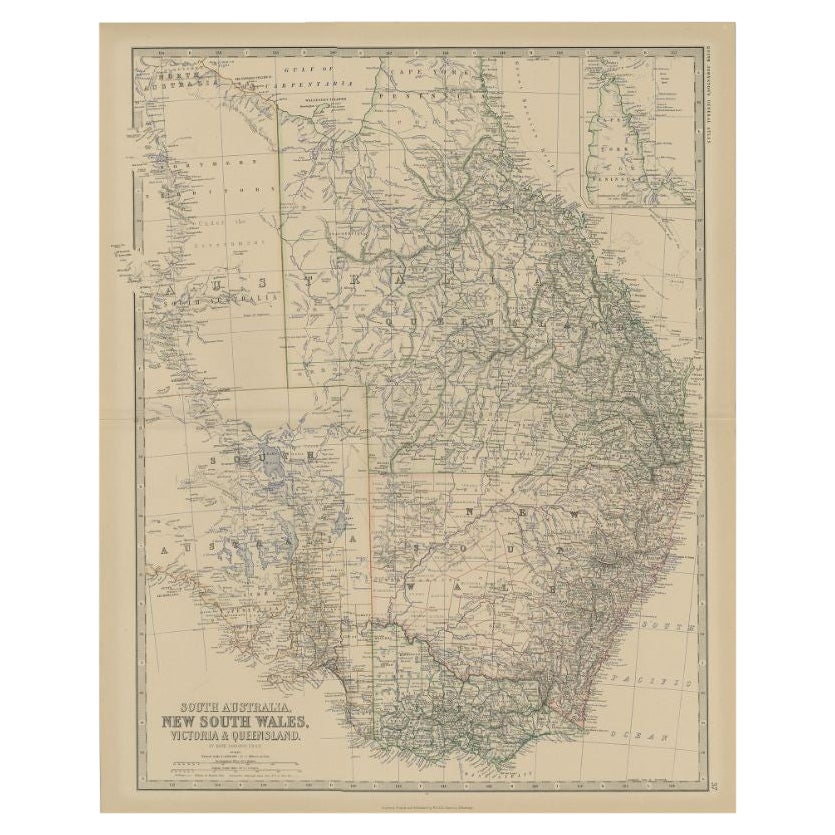
- Antique Map of South Australia by Johnston, 1882By Thomas KitchinLocated in Langweer, NLAntique map titled 'South Australia, New South Wales, Victoria & Queensland'. Old map of Southern Australia, with an inset map of Cape York Peninsula. This map originates from 'The R...Category
Antique 19th Century Maps
MaterialsPaper

You May Also Like
- Original Antique Map of South America. C.1780Located in St Annes, LancashireGreat map of South America Copper-plate engraving Published C.1780 Two small worm holes to left side of map Unframed.Category
Antique Early 1800s English Georgian Maps
MaterialsPaper
- Original Antique Map of South America, circa 1830Located in St Annes, LancashireGreat map of South America Copper plate engraving Published by Butterworth, Livesey & Co., circa 1830 Unframed.Category
Antique Early 1800s English Other Maps
MaterialsPaper
- Original Antique Map of South America by Thomas Clerk, 1817Located in St Annes, LancashireGreat map of South America Copper-plate engraving Drawn and engraved by Thomas Clerk, Edinburgh. Published by Mackenzie And Dent, 1817 Unframed.Category
Antique 1810s English Maps
MaterialsPaper
- Original Antique Decorative Map of South America-West Coast, Fullarton, C.1870Located in St Annes, LancashireGreat map of Chili, Peru and part of Bolivia Wonderful figural border From the celebrated Royal Illustrated Atlas Lithograph. Original color. Published by Fullarton, Edi...Category
Antique 1870s Scottish Maps
MaterialsPaper
- Antique Lithography Map, South America, English, Framed, Cartography, VictorianLocated in Hele, Devon, GBThis is an antique lithography map of South America. An English, framed atlas engraving of cartographic interest by John Rapkin , dating to the early Victorian period and later, circ...Category
Antique Mid-19th Century British Early Victorian Maps
MaterialsWood
- Original Antique Map of South Africa, Arrowsmith, 1820Located in St Annes, LancashireGreat map of South Africa. Drawn under the direction of Arrowsmith. Copper-plate engraving. Published by Longman, Hurst, Rees, Orme and Br...Category
Antique 1820s English Maps
MaterialsPaper


Recently Viewed
View AllMore Ways To Browse
Antique Prince And
Antique American 18th Century Furniture
Munich Antiques
18th Century American Antiques
Antique World Map Print
American Wood 18th Century Furniture
18th C American
18th C American Furniture
Bavaria Antique
Antique Hebrew
Old American Maps
Old Maps Of Europe
Old Europe Map
Thomas Toner
Engravings 1700
Antique Prints Mountains
Lithograph City Maps
City Map Lithograph