Items Similar to Antique Map of Tartary, Also Showing the Great Wall of China


Want more images or videos?
Request additional images or videos from the seller
1 of 6
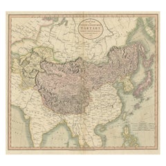
Antique Map of Tartary, Also Showing the Great Wall of China
About the Item
Antique map titled 'Carte de Tartarie'. Detailed map of Tartary, consisting of the Eastern part of Russia, Central Asia, China and Korea, first published by Guillaume De L'Isle in 1706. The map extends from the Peninsula of Korea in the east to the Caspian and Black Seas. The Great Wall of China is shown, as is the Silk Route, many roads and remote settlements, mountain ranges, rivers, etc. The wide swath of the Gobi Desert appears quite prominently, as does the Great Kingdom of Tibet, Cossack regions, the Country of the Mongols and many other features. Published circa 1718 (2nd state), with imprint "Premier Geo. du Roi" added in the cartouche.
- Dimensions:Height: 20.36 in (51.7 cm)Width: 27.17 in (69 cm)Depth: 0.02 in (0.5 mm)
- Materials and Techniques:
- Period:
- Date of Manufacture:c.1718
- Condition:Age-related toning. Few tears in margins, sl. affecting image. Shows strong wear and soiling, blank verso with manuscript title. Please study image carefully.
- Seller Location:Langweer, NL
- Reference Number:
About the Seller
5.0
Platinum Seller
These expertly vetted sellers are 1stDibs' most experienced sellers and are rated highest by our customers.
Established in 2009
1stDibs seller since 2017
1,928 sales on 1stDibs
Typical response time: <1 hour
- ShippingRetrieving quote...Ships From: Langweer, Netherlands
- Return PolicyA return for this item may be initiated within 14 days of delivery.
More From This SellerView All
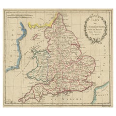
- Antique Map of England, Also Showing CalaisLocated in Langweer, NLAntique map titled 'Carte de l'Angleterre pour le Voyage dans les trois Royaumes'. Original old map of England, also showing Calais. This map originates from 'Voyage dans les trois r...Category
Antique Late 18th Century Maps
MaterialsPaper
- Antique Map of the United States of America, also showing the CaribbeanLocated in Langweer, NLAntique map titled 'Verein-Staaten von Nord-America, Mexico, Yucatan u.a.'. Very detailed map of the United States of America showing the ...Category
Antique Mid-19th Century Maps
MaterialsPaper
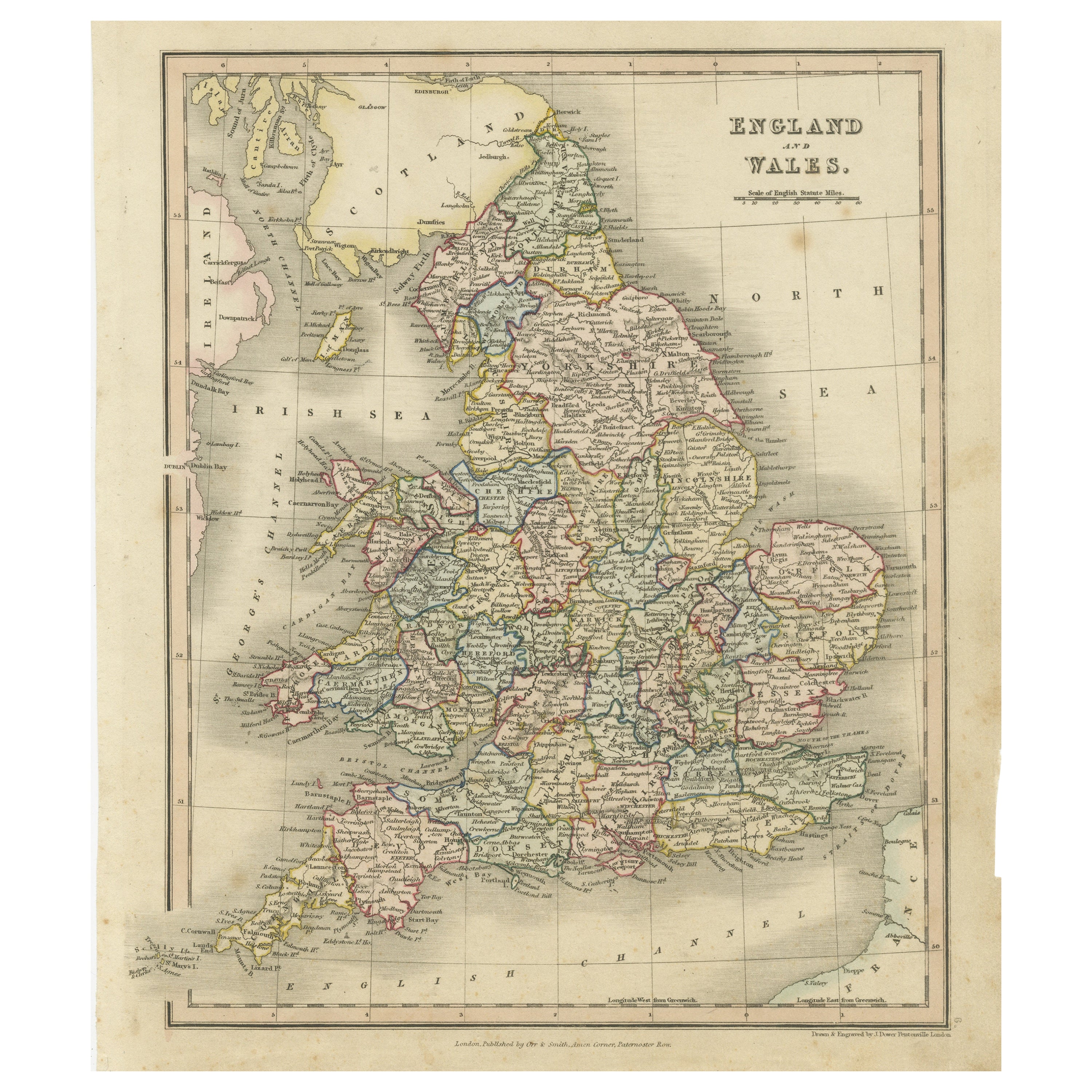
- Antique Map of England and Wales, Also Showing the English ChannelLocated in Langweer, NLAntique map titled 'England and Wales'. Original antique map of England and Wales. Drawn and engraved by J. Dower. Originates from 'A General Descriptive Atlas Of The Earth, Containi...Category
Antique Mid-19th Century Maps
MaterialsPaper
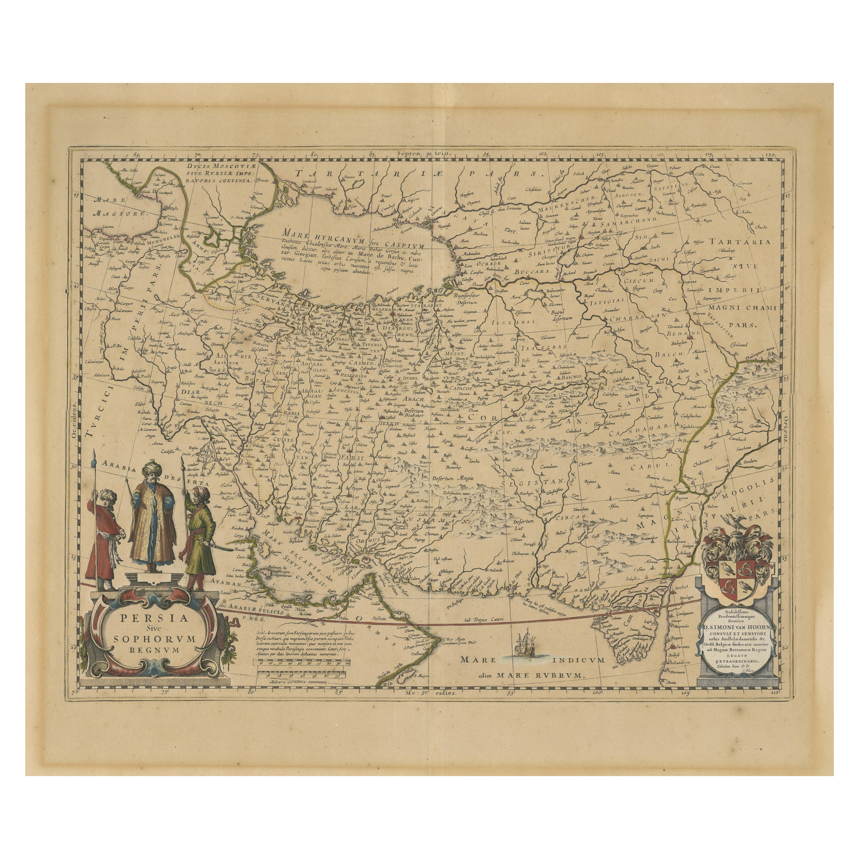
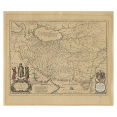
- Antique Map of Persia, Also Showing the Indus River, circa 1673By Joan (Johannes) BlaeuLocated in Langweer, NLAntique map titled 'Persia sive Sophorum Regnum'. Original old map of Persia. The map extends from the Eastern Mediterranean to Tacalistan and the Indus River and the Dalanguer Mount...Category
Antique Late 17th Century Maps
MaterialsPaper
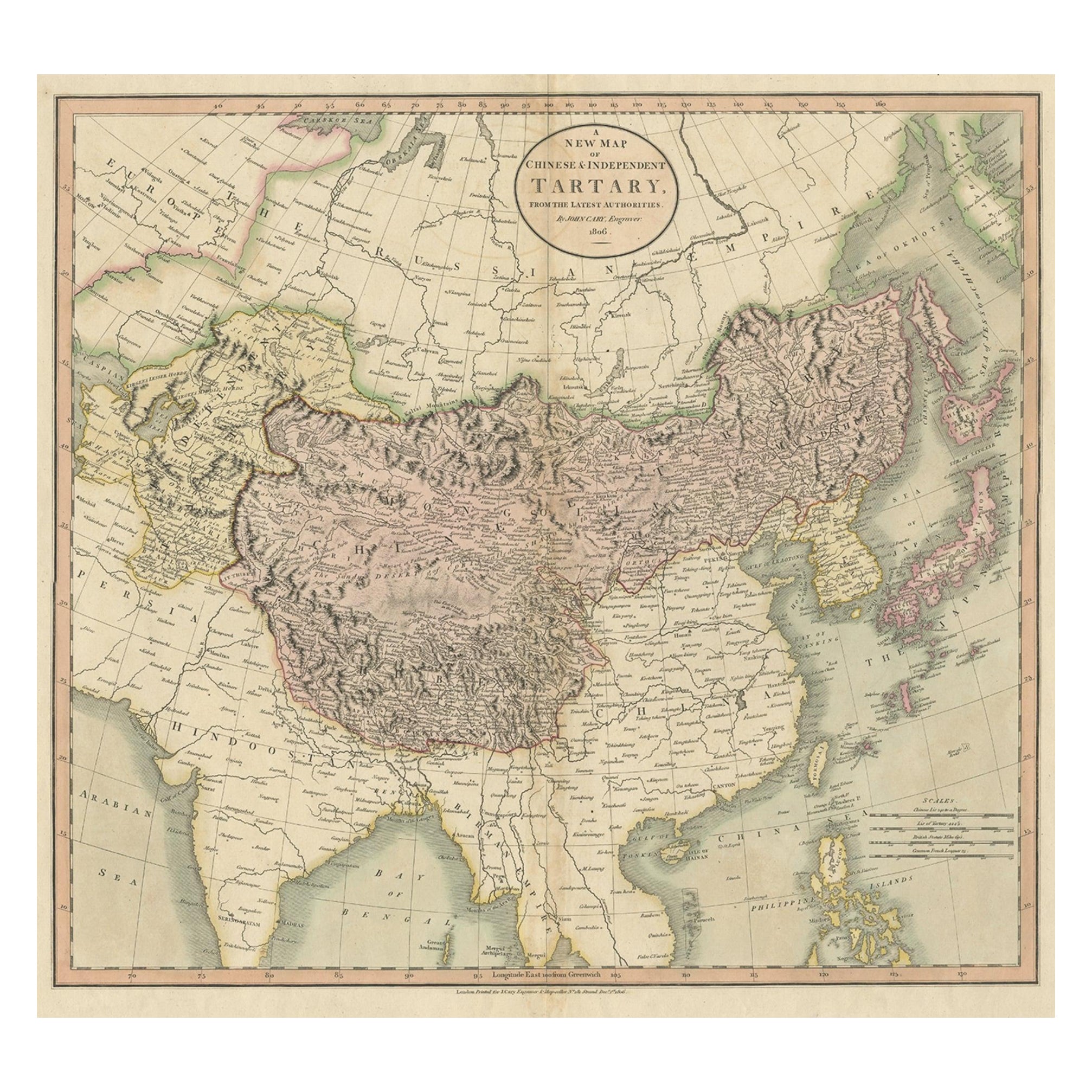
- Antique Map of Chinese and Independent Tartary, Korea and Japan, 1806Located in Langweer, NLAntique map titled 'A New Map of Chinese & Independent Tartary'. Beautiful map of Chinese Tartary, Korea and Japan. Artists and Engravers: John Cary (1755-1835) was a British car...Category
Antique 19th Century Maps
MaterialsPaper
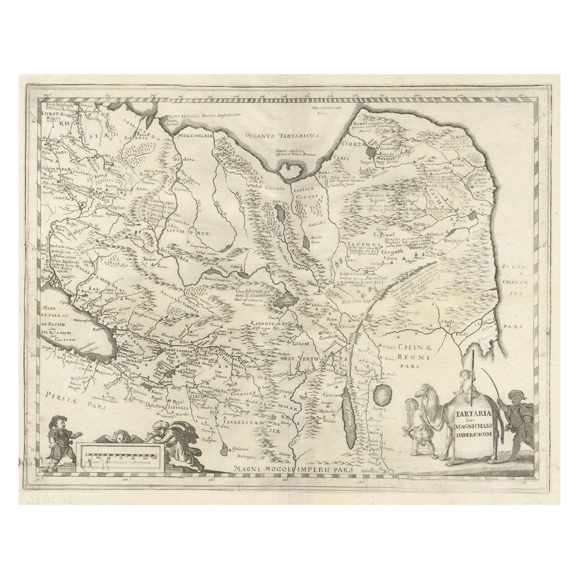
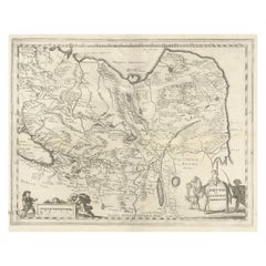
- Antique Map of China, Tartary and Central Asia by Blaeu, c.1645Located in Langweer, NLAntique map titled ‘Tartaria sive Magnichami Imperiorum‘. Early map of Siberia based upon the journals of Marco Polo. The map covers from the Caspian Sea and the Volga River east as far as the China Sea and the city of Xanadu. It extends north to Nova Zembla and south to the Upper Ganges River. When Blaeu drew this map this part of the world was almost entirely unknown. Blaeu relied on the journals of Marco Polo to compile most of the map. Devils and dragons frolic in the Lop Nor and far to the north the summer seat...Category
Antique 17th Century Maps
MaterialsPaper


You May Also Like
- Original Antique Map of China, Arrowsmith, 1820Located in St Annes, LancashireGreat map of China Drawn under the direction of Arrowsmith Copper-plate engraving Published by Longman, Hurst, Rees, Orme and Brown, 1820 Unfr...Category
Antique 1820s English Maps
MaterialsPaper
- Original Antique Map of China by Thomas Clerk, 1817Located in St Annes, LancashireGreat map of China Copper-plate engraving Drawn and engraved by Thomas Clerk, Edinburgh. Published by Mackenzie And Dent, 1817 Unframed.Category
Antique 1810s English Maps
MaterialsPaper
- Map of the Republic of GenoaLocated in New York, NYFramed antique hand-coloured map of the Republic of Genoa including the duchies of Mantua, Modena, and Parma. Europe, late 18th century. Dimension: 25...Category
Antique Late 18th Century European Maps
- Antique Map of Principality of MonacoBy Antonio Vallardi EditoreLocated in Alessandria, PiemonteST/619 - "Old Geographical Atlas of Italy - Topographic map of ex-Principality of Monaco" - ediz Vallardi - Milano - A somewhat special edition ---Category
Antique Late 19th Century Italian Other Prints
MaterialsPaper
- Original Antique Map of The World by Thomas Clerk, 1817Located in St Annes, LancashireGreat map of The Eastern and Western Hemispheres On 2 sheets Copper-plate engraving Drawn and engraved by Thomas Clerk, Edinburgh. Published by Mackenzie And Dent, 1817 ...Category
Antique 1810s English Maps
MaterialsPaper
- England, Scotland & Ireland: A Hand Colored Map of Great Britain by TirionBy Isaak TirionLocated in Alamo, CAThis is a hand-colored double page copperplate map of Great Britain entitled "Nieuwe Kaart van de Eilanden van Groot Brittannien Behelzende de Kon...Category
Antique Mid-18th Century Dutch Maps
MaterialsPaper


