Items Similar to Antique Map of Walcheren in the Province of Zeeland, the Netherlands, ca.1910
Want more images or videos?
Request additional images or videos from the seller
1 of 5
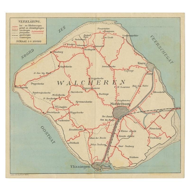
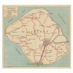
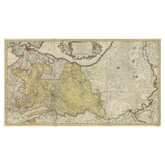
Antique Map of Walcheren in the Province of Zeeland, the Netherlands, ca.1910
About the Item
Antique map of Walcheren, part of the province of Zeeland, the Netherlands.
Shows the cities of Veere, Middelburg, Vlissingen and others. Source unknown, to be determined. Published c.1910.
Walcheren is a region and former island in the Dutch province of Zeeland at the mouth of the Scheldt estuary. It lies between the Eastern Scheldt in the north and the Western Scheldt in the south and is roughly the shape of a rhombus. The two sides facing the North Sea consist of dunes and the rest of its coastline is made up of dykes. Middelburg, the provincial capital, lies at Walcheren's centre. Vlissingen, 9 kilometres (5.6 mi) to the south, is the main harbour and the third municipality is Veere.
Originally, Walcheren was an island, but the Sloedam, constructed in 1871 for a railway, and poldering after World War II have connected it to the (former) island of Zuid-Beveland, which in turn has been connected to the North Brabant mainland.
World War II
Strategically situated at the mouth of the River Scheldt, Walcheren was the key that allowed use of the deep-water port of Antwerp, located further upstream on the right bank of the southern estuary of the river. It was fought over during World War II in 1940 between Dutch and German troops in the Battle of the Netherlands, and again in 1944 in the Battle of Walcheren Causeway, the fourth and final stage of the Battle of the Scheldt. On 3 October 1944 the RAF bombed the sea wall at Westkapelle causing the Inundation of Walcheren. The 2nd Canadian Infantry Division cleared South Beveland to the east and approached the island on 31 October 1944. The plan was to cross the Sloe Channel, but leading troops of the 5th Canadian Infantry Brigade found that assault boats were useless in the deep mud of the channel. The only route open was the 40 metre wide Walcheren Causeway, a mile-long land bridge from South Beveland to the island. The Canadian Black Watch sent a company across on the evening of 31 October, but was stopped. The Calgary Highlanders sent two companies over in succession, the second attack opening up a bridgehead on the island. The Highlanders were eventually thrown back, having lost 64 killed and wounded. Le Régiment de Maisonneuve relieved them on the causeway, followed by the 1st Battalion, Glasgow Highlanders of the British 52nd Infantry Division.
Meanwhile, on 1 November 1944, British Commandos landed in the village of Westkapelle in order to silence the German coastal batteries looking out over the Scheldt. The amphibious assault (Operation Infatuate) proved a success and by 8 November, all German resistance on the island had ceased. (Source; Wikipedia)
Artists and Engravers: Lithographed by G.W. den Boer.
Condition: Good, general age-related toning. Original folding line. Minor wear and soiling, Dutch advertisements on verso. Please study image carefully.
- Dimensions:Height: 7.49 in (19 cm)Width: 8.08 in (20.5 cm)Depth: 0 in (0.02 mm)
- Materials and Techniques:
- Period:1910-1919
- Date of Manufacture:circa 1910
- Condition:
- Seller Location:Langweer, NL
- Reference Number:
About the Seller
5.0
Platinum Seller
These expertly vetted sellers are 1stDibs' most experienced sellers and are rated highest by our customers.
Established in 2009
1stDibs seller since 2017
1,929 sales on 1stDibs
Typical response time: <1 hour
- ShippingRetrieving quote...Ships From: Langweer, Netherlands
- Return PolicyA return for this item may be initiated within 14 days of delivery.
More From This SellerView All
- Antique Map of Walcheren in Zeeland, the Netherlands, c.1910Located in Langweer, NLAntique map of Walcheren, part of the province of Zeeland, the Netherlands. Shows the cities of Veere, Middelburg, Vlissingen and others. Source unknown, to be determined. Published ...Category
20th Century Maps
MaterialsPaper
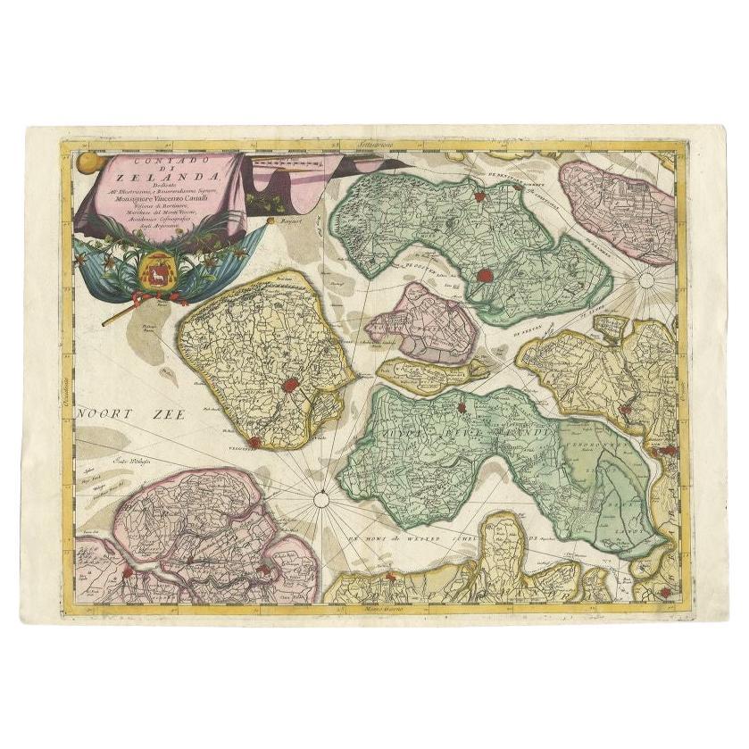
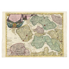
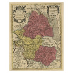
- Antique Map of the Province of Zeeland, The Netherlands by Coronelli, 1692Located in Langweer, NLAntique map titled 'Contado di Zelanda'. Beautiful map of the Dutch province of Zeeland. With the islands of Walcheren, Schouwen-Duiveland, Noord-Beveland, Zuid-Beveland, Tholen and ...Category
Antique 17th Century Maps
MaterialsPaper
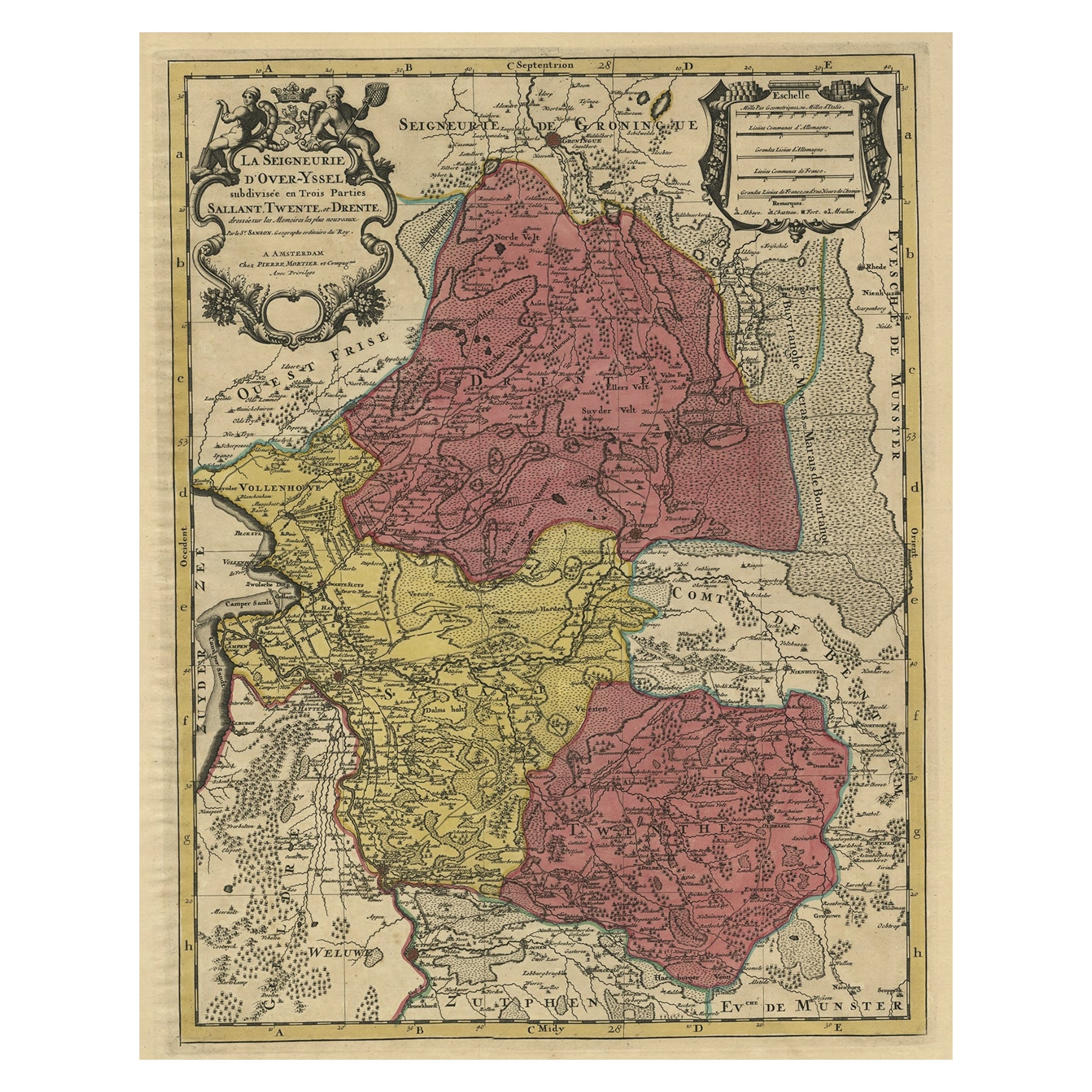
- Detailed Antique Map of the Province of Overijssel in the Netherlands, ca.1700Located in Langweer, NLAntique map titled 'La Seigneurie d'Over-Yssel subdivisee en Trois Parties, Sallant, Twente, et Drente.' Detailed map of the province of Overijssel in the Netherlands. From Jaill...Category
Antique Early 1700s Maps
MaterialsPaper
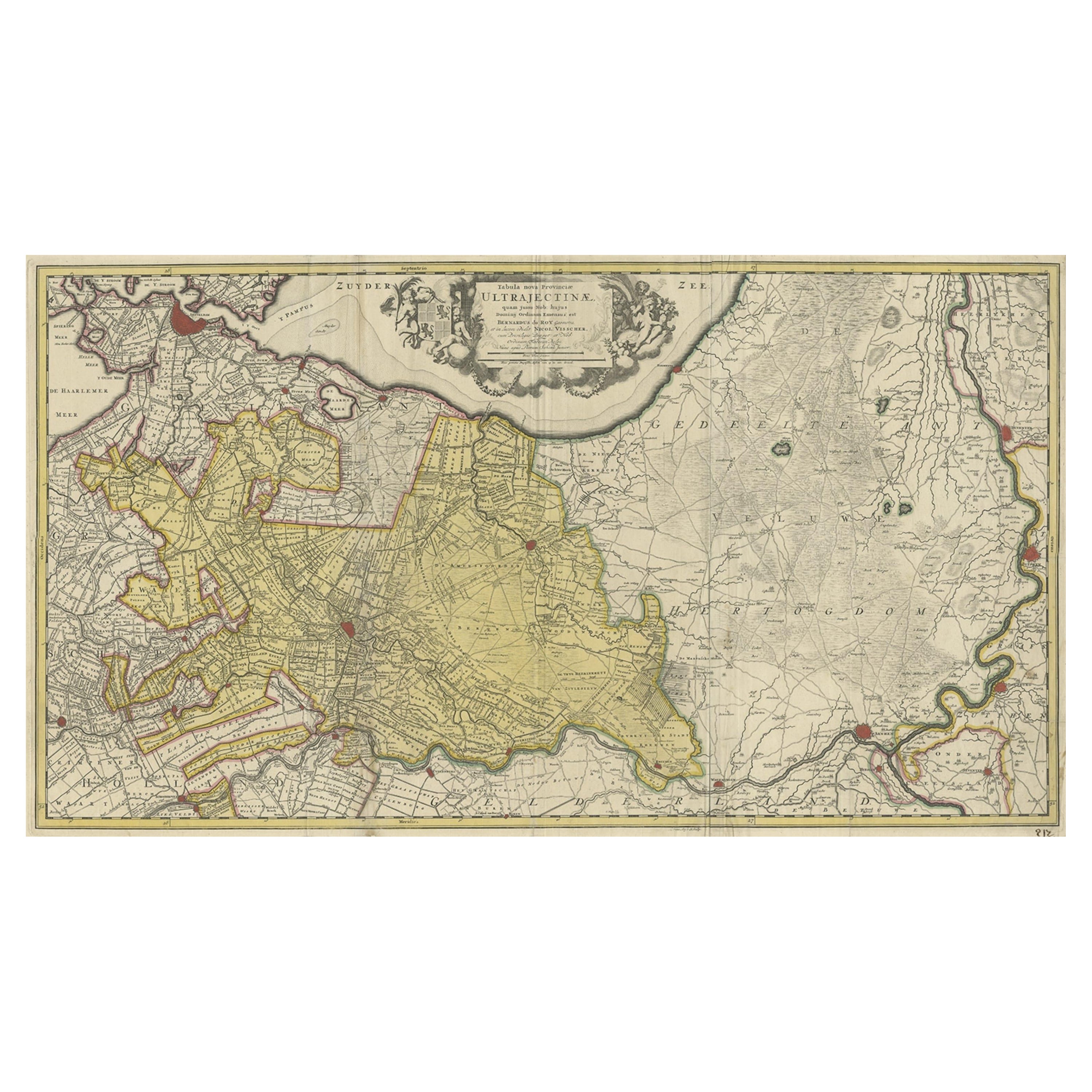
- Original Antique Map of the Province of Utrecht, the Netherlands, ca.1720Located in Langweer, NLAntique map titled ‘Tabula Nova Provinciae Ultrajectinae (..)’. Original antique map of the province of Utrecht, the Netherlands. It shows the region of Amsterdam, Utrecht, Gouda, ...Category
Antique 1720s Maps
MaterialsPaper
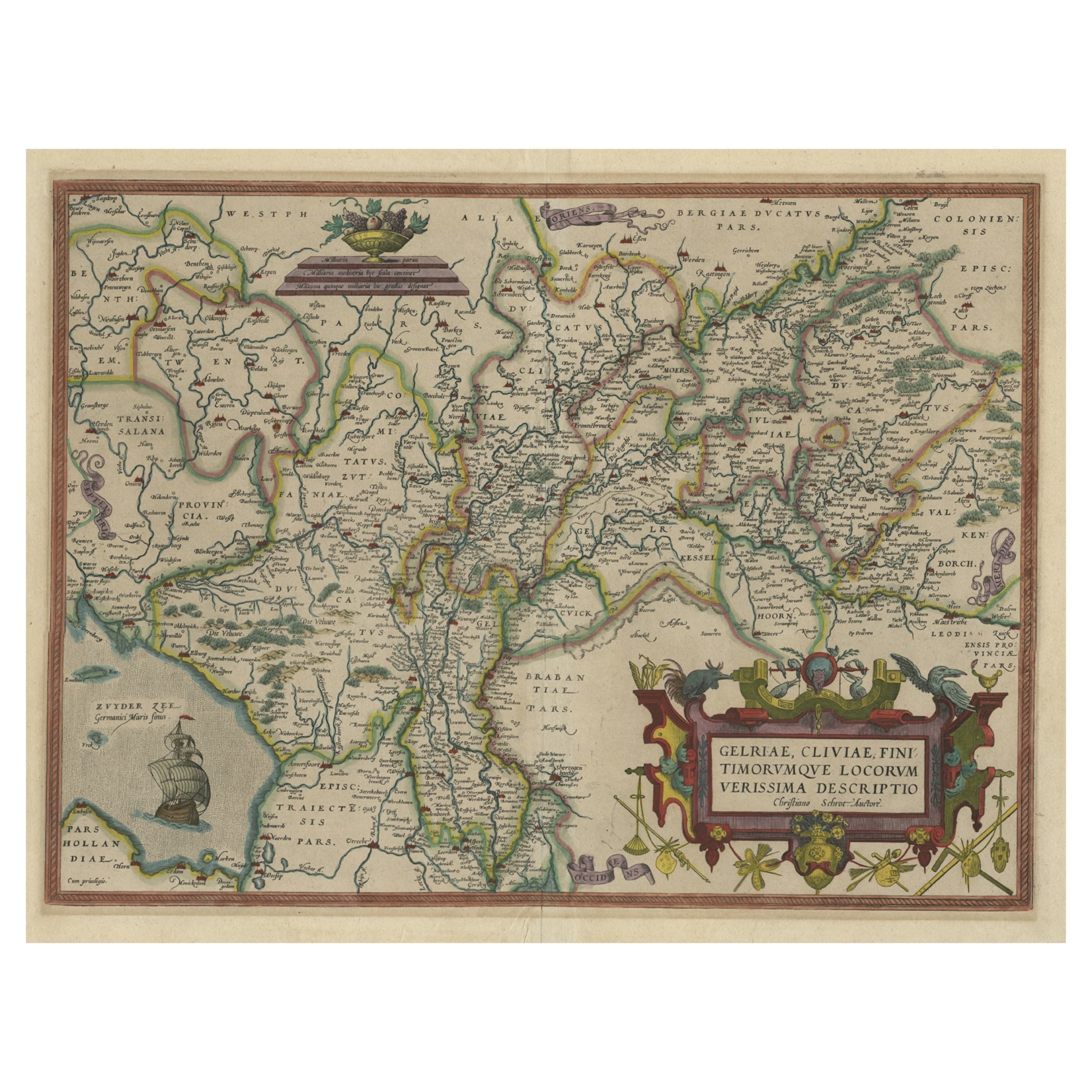
- Superb Antique Map of the Province of Gelderland, the Netherlands, ca.1575Located in Langweer, NLAntique map titled 'Gelriae, Cliviae, Finitimorumque Locorum Verissima Descriptio Christiano Schrot. Auctore'. This superb map is Ortelius' first plate covering Gelderland. It is...Category
Antique 16th Century Maps
MaterialsPaper
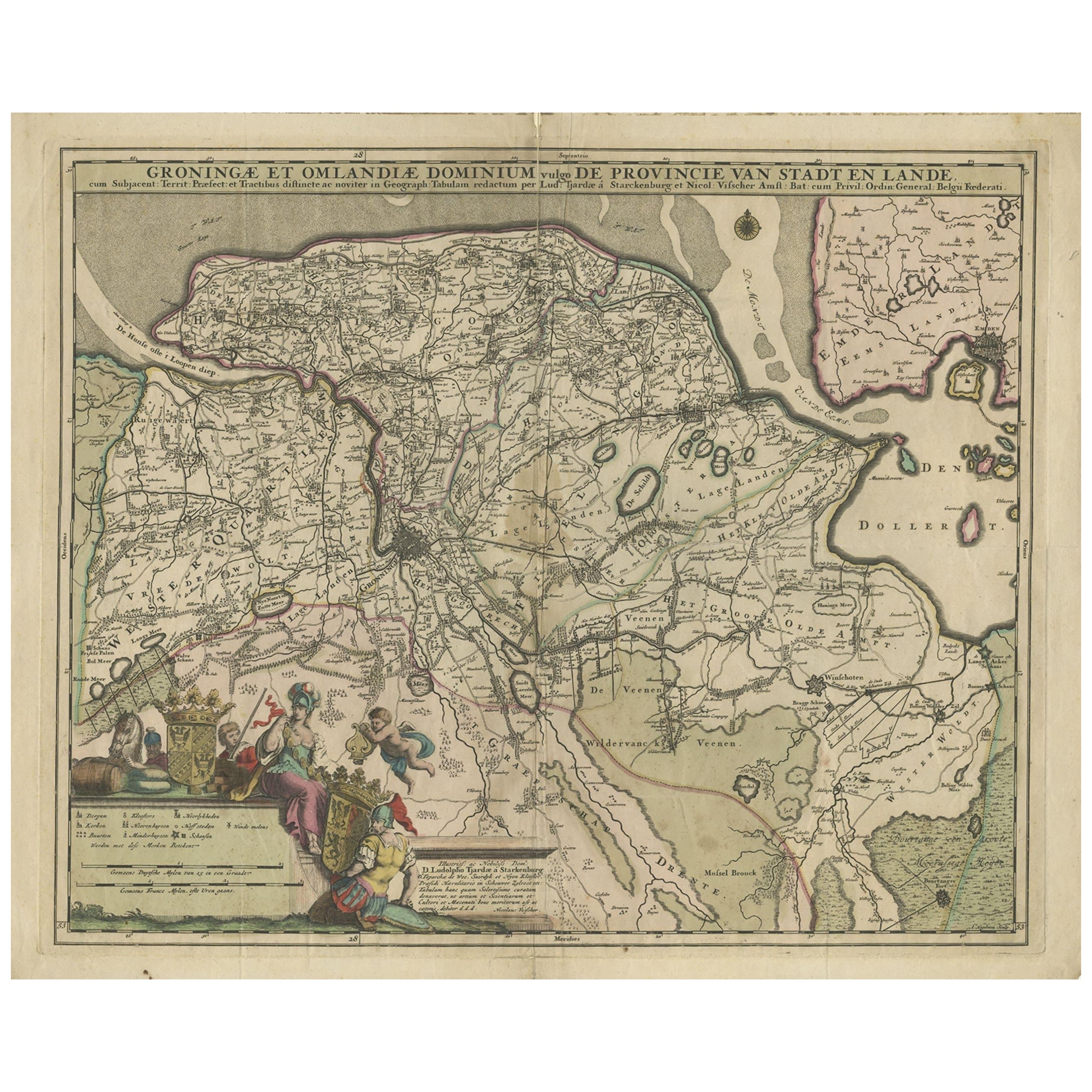
- Antique Map of the Province Groningen in The Netherlands, c.1680Located in Langweer, NLAntique map titled 'Groningae et Omlandiae Dominium vulgo de Provincie van Stadt en Lande'. Old map of the province of Groningen, the Netherlands. This map originates from 'Germani...Category
Antique 17th Century Maps
MaterialsPaper
You May Also Like
- Antique 18th Century Map of the Province of Pensilvania 'Pennsylvania State'Located in Philadelphia, PAA fine antique of the colony of Pennsylvania. Noted at the top of the sheet as a 'Map of the province of Pensilvania'. This undated and anonymous map is thought to be from the Gentleman's Magazine, London, circa 1775, although the general appearance could date it to the 1760's. The southern boundary reflects the Mason-Dixon survey (1768), the western boundary is placed just west of Pittsburgh, and the northern boundary is not marked. The map has a number of reference points that likely refer to companion text and appear to be connected to boundaries. The western and southern boundaries are marked Q, R, S, for example. A diagonal line runs from the Susquehanna R to the Lake Erie P. A broken line marked by many letters A, B, N, O, etc., appears in the east. There are no latitude or longitude markings, blank verso. Framed in a shaped contemporary gilt wooden frame and matted under a cream colored matte. Bearing an old Graham Arader Gallery...Category
Antique 18th Century British American Colonial Maps
MaterialsPaper
- Original Antique Map of The Netherlands, Engraved by Barlow, Dated 1807Located in St Annes, LancashireGreat map of Netherlands Copper-plate engraving by Barlow Published by Brightly & Kinnersly, Bungay, Suffolk. Dated 1807 Unframed.Category
Antique Early 1800s English Maps
MaterialsPaper
- Original Antique Map of The Netherlands, Sherwood, Neely & Jones, Dated 1809Located in St Annes, LancashireGreat map of The Netherlands Copper-plate engraving by Cooper Published by Sherwood, Neely & Jones. Dated 1809 Unframed.Category
Antique Early 1800s English Maps
MaterialsPaper
- Map of the Republic of GenoaLocated in New York, NYFramed antique hand-coloured map of the Republic of Genoa including the duchies of Mantua, Modena, and Parma. Europe, late 18th century. Dimension: 25...Category
Antique Late 18th Century European Maps
- Antique Map of Principality of MonacoBy Antonio Vallardi EditoreLocated in Alessandria, PiemonteST/619 - "Old Geographical Atlas of Italy - Topographic map of ex-Principality of Monaco" - ediz Vallardi - Milano - A somewhat special edition ---Category
Antique Late 19th Century Italian Other Prints
MaterialsPaper
- Original Antique Map of The World by Thomas Clerk, 1817Located in St Annes, LancashireGreat map of The Eastern and Western Hemispheres On 2 sheets Copper-plate engraving Drawn and engraved by Thomas Clerk, Edinburgh. Published by Mackenzie And Dent, 1817 ...Category
Antique 1810s English Maps
MaterialsPaper


Recently Viewed
View AllMore Ways To Browse
Map Wall
Antique Wall Map
Antique Wall Maps
Netherlands War
World Map Wall
Antique World War Ii
Antique Furniture In Glasgow
Antique Watch Images
Antique Wall World Map
Antique Wall Maps Of The World
Route Map
Used Watch Canada
British World War 1
Antique Watch Collectibles
Long Island Map
Map Of Long Island
Maps Of Long Island
Antique Maps Of Britain