Items Similar to Antique Map of the World on Mercator Projection by Anson, 1749


Want more images or videos?
Request additional images or videos from the seller
1 of 6
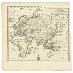
Antique Map of the World on Mercator Projection by Anson, 1749
$438.89
$585.1825% Off
£324.54
£432.7225% Off
€367.50
€49025% Off
CA$602.85
CA$803.8025% Off
A$670.34
A$893.7825% Off
CHF 350.93
CHF 467.9125% Off
MX$8,188.30
MX$10,917.7325% Off
NOK 4,409.83
NOK 5,879.7725% Off
SEK 4,148.33
SEK 5,531.1025% Off
DKK 2,798.23
DKK 3,730.9725% Off
About the Item
Antique map titled 'Nieuwe Wereld Kaart waar in de Reizen van den Hr. Anson rondsom de Wereld'. Original antique map of the world on Mercator's Projection from a Dutch edition of Anson's voyages. The map includes California as an Island, an incomplete Australia which connects to New Guinea, no Southern Hemisphere, Northwest passage, no New Zealand and a host of other cartorgraphic misconceptions. Shows Anson's tracks around the world. This map originates from 'Reize rondsom de Werreld (..)' by George Anson, published 1749.
Artists and Engravers: Admiral of the Fleet George Anson, 1st Baron Anson, PC, FRS (23 April 1697 – 6 June 1762) was a Royal Navy officer.
Condition: Good, general age-related toning. Original folding lines. Minor wear, some foxing. Blank verso, please study image carefully.
We sell original antique maps to collectors, historians, educators and interior decorators all over the world. Our collection includes a wide range of authentic antique maps from the 16th to the 20th centuries. Buying and collecting antique maps is a tradition that goes back hundreds of years. Antique maps have proved a richly rewarding investment over the past decade, thanks to a growing appreciation of their unique historical appeal. Today the decorative qualities of antique maps are widely recognized by interior designers who appreciate their beauty and design flexibility. Depending on the individual map, presentation, and context, a rare or antique map can be modern, traditional, abstract, figurative, serious or whimsical. We offer a wide range of authentic antique maps for any budget.
- Dimensions:Height: 10.63 in (27 cm)Width: 16.74 in (42.5 cm)Depth: 0 in (0.01 mm)
- Materials and Techniques:
- Period:
- Date of Manufacture:1749
- Condition:Condition: Good, general age-related toning. Original folding lines. Minor wear, some foxing. Blank verso, please study image carefully.
- Seller Location:Langweer, NL
- Reference Number:Seller: BG-11589-131stDibs: LU3054329302492
About the Seller
5.0
Recognized Seller
These prestigious sellers are industry leaders and represent the highest echelon for item quality and design.
Platinum Seller
Premium sellers with a 4.7+ rating and 24-hour response times
Established in 2009
1stDibs seller since 2017
2,599 sales on 1stDibs
Typical response time: <1 hour
- ShippingRetrieving quote...Shipping from: Langweer, Netherlands
- Return Policy
Authenticity Guarantee
In the unlikely event there’s an issue with an item’s authenticity, contact us within 1 year for a full refund. DetailsMoney-Back Guarantee
If your item is not as described, is damaged in transit, or does not arrive, contact us within 7 days for a full refund. Details24-Hour Cancellation
You have a 24-hour grace period in which to reconsider your purchase, with no questions asked.Vetted Professional Sellers
Our world-class sellers must adhere to strict standards for service and quality, maintaining the integrity of our listings.Price-Match Guarantee
If you find that a seller listed the same item for a lower price elsewhere, we’ll match it.Trusted Global Delivery
Our best-in-class carrier network provides specialized shipping options worldwide, including custom delivery.More From This Seller
View AllAntique Map of the World on Mercator's Projection, 1788
Located in Langweer, NL
Antique map titled 'Kaart van de Geheele Wereld (..)'. Uncommon small world map on Mercator's projection. Nice detail of the islands throughout the wor...
Category
Antique Late 18th Century Maps
Materials
Paper

$716 Sale Price
20% Off
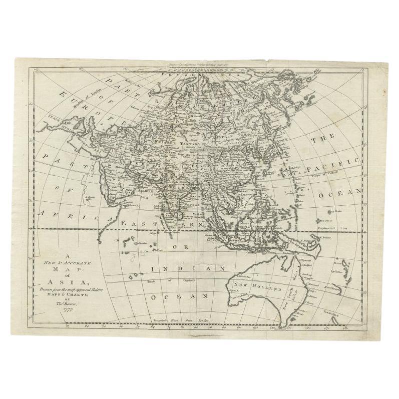
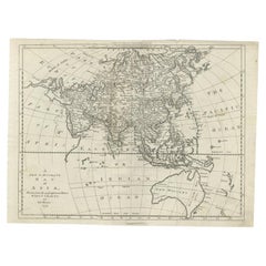
Antique Map of Asia and Australia with a Speculative Coastline, 1777
Located in Langweer, NL
Antique map titled 'A New & Accurate Map of Asia'. Detailed map of Asia and Australia, shows a still largely speculative Southern Australian coastline. Originates from Middleton's 'C...
Category
Antique 18th Century Maps
Materials
Paper
$401 Sale Price
20% Off
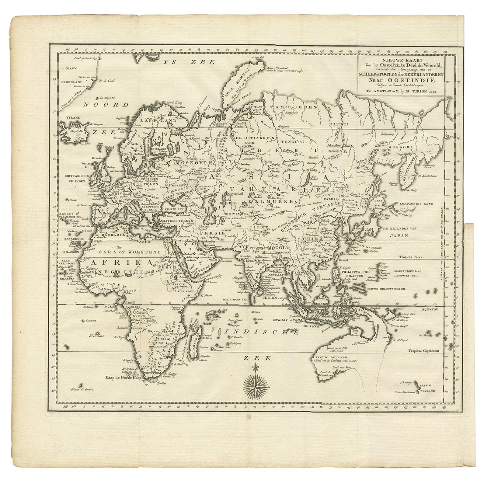
Antique Map of the Eastern Part of the World by Tirion, 1755
By Isaak Tirion
Located in Langweer, NL
Antique map titled 'Nieuwe Kaart van het Oostelykste Deel der Weereld, dienende tot Aanwyzing van de Scheepstogten der Nederlanderen naar Oostindië'. Australia (Nieuw Holland) shown ...
Category
Antique Mid-18th Century Dutch Maps
Materials
Paper
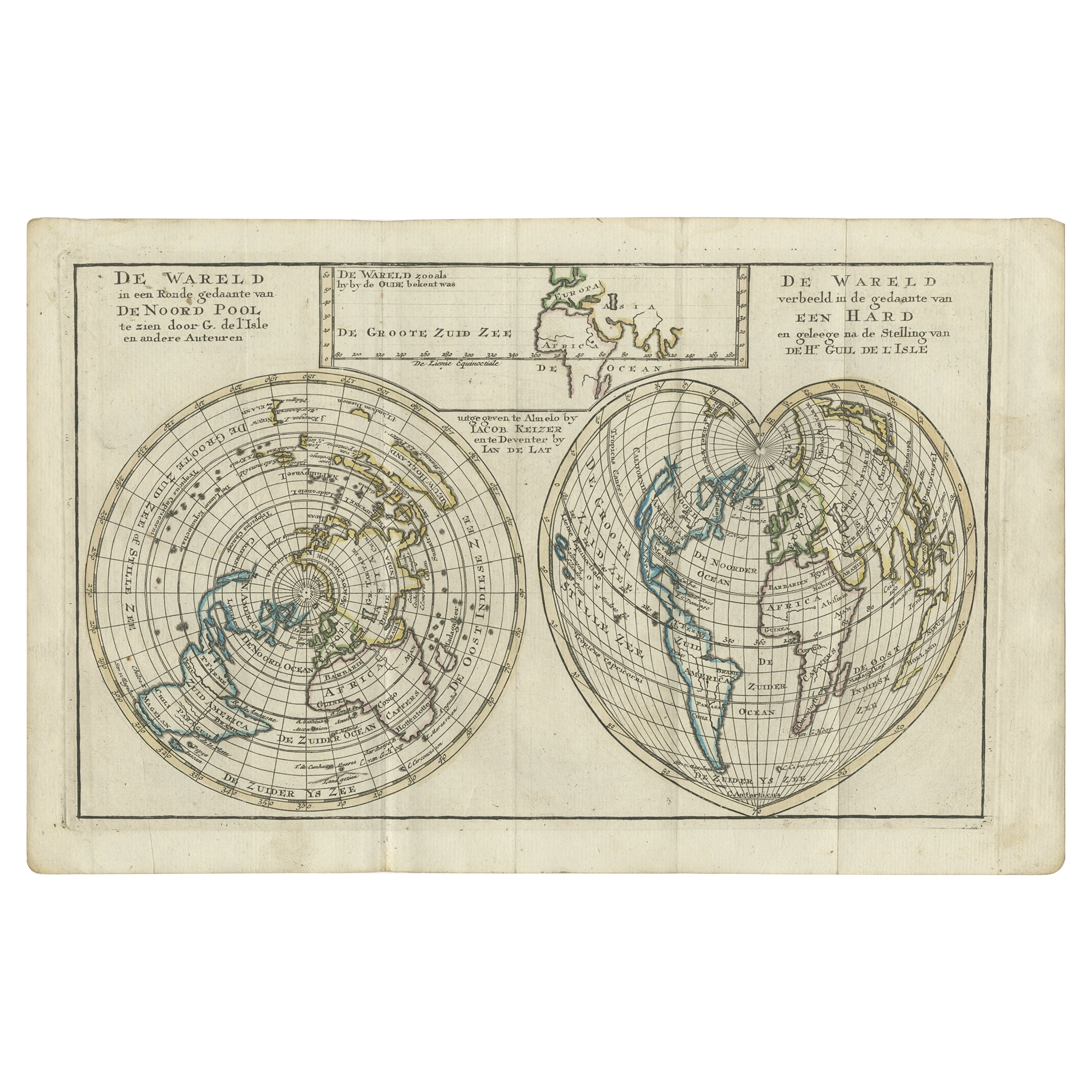
Antique Map of the World with California as an Island, 1788
Located in Langweer, NL
Description: Antique map titled 'De wareld in een ronde gedaante van de Noord Pool te zien - De Wareld verbeeld in de gedaante van een hard'. This interesting composition contains three world maps on the sheet. At left is a northern projection showing all the landmasses. At right is a cordiform projection (heart-shaped). At top is a map of the world as known to the ancients. Both the polar and cordiform projections show California as an island...
Category
Antique 1780s Maps
Materials
Paper

$621 Sale Price
20% Off
Antique Map of the World, Mercator Projection, by Wyld, '1845'
Located in Langweer, NL
Antique map titled 'The World'. Original antique world map, on Mercator's projection. This map originates from 'An Atlas of the World, Compr...
Category
Antique Mid-19th Century Maps
Materials
Paper

$334 Sale Price
20% Off
Very Decorative Original Antique Map of the World, Published in France in c.1780
By Rigobert Bonne
Located in Langweer, NL
Antique map titled 'L'Ancien Monde Et Le Nouveau en Deux Hemispheres' - Double hemisphere map of the World, showing the contemporary geographical...
Category
Antique 18th Century Maps
Materials
Paper

$735 Sale Price
20% Off
You May Also Like
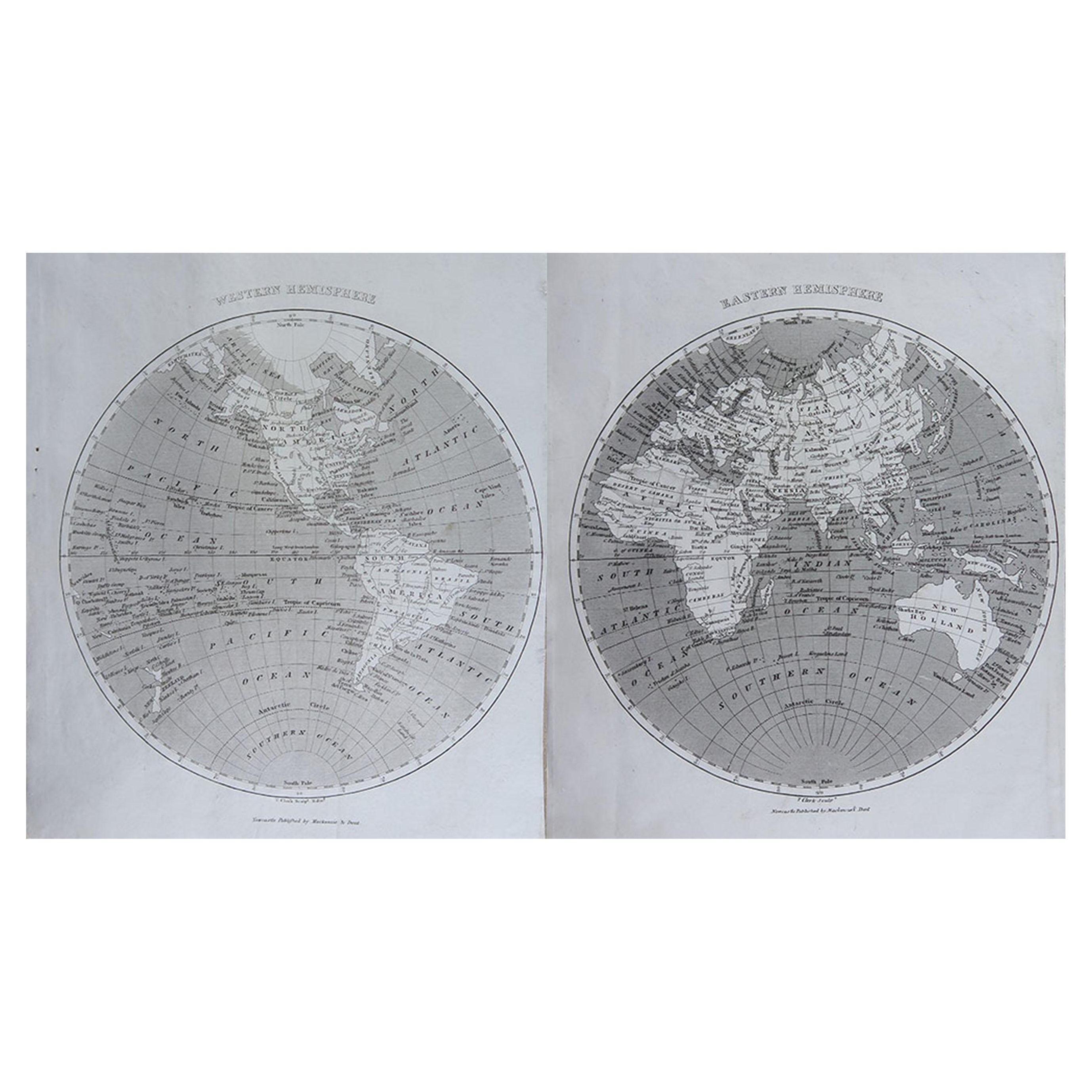
Original Antique Map of The World by Thomas Clerk, 1817
Located in St Annes, Lancashire
Great map of The Eastern and Western Hemispheres
On 2 sheets
Copper-plate engraving
Drawn and engraved by Thomas Clerk, Edinburgh.
Published by Mackenzie And Dent, 1817
...
Category
Antique 1810s English Maps
Materials
Paper

Original Antique Map of The World by Dower, circa 1835
Located in St Annes, Lancashire
Nice map of the World
Drawn and engraved by J.Dower
Published by Orr & Smith. C.1835
Unframed.
Free shipping
Category
Antique 1830s English Maps
Materials
Paper

1864 Johnson's Map of the World on Mercator's Projection, Ric.B009
Located in Norton, MA
An 1864 Johnson's map of
the World on Mercator's Projection
Ric.b009
About this Item
"This antique map came from Johnson's New Illustrated (Steel Plate) Family Atlas, publ...
Category
Antique 19th Century Dutch Maps
Materials
Paper

Original Antique Map of The Western Hemisphere by Dower, circa 1835
Located in St Annes, Lancashire
Nice map of the Western Hemisphere
Drawn and engraved by J.Dower
Published by Orr & Smith. C.1835
Unframed.
Free shipping
Category
Antique 1830s English Maps
Materials
Paper

Original Antique Map of The Eastern Hemisphere by Dower, circa 1835
Located in St Annes, Lancashire
Nice map of the Eastern Hemisphere
Drawn and engraved by J.Dower
Published by Orr & Smith. C.1835
Unframed.
Free shipping
Category
Antique 1830s English Maps
Materials
Paper

1850 Old French Map Depicting the Entire Earth's Surface Divided into Two Parts
Located in Milan, IT
Geographical map depicting the entire earth's surface divided into two parts that correspond to the two hemispheres where the emerged lands are depicted which have been classified wi...
Category
Antique Mid-19th Century French Maps
Materials
Glass, Wood, Paper

More Ways To Browse
Antique Maps Massachusetts
Guyana Antique Map
Peninsular War
Santa Cruz Island
Ukraine Antique Map
Antique Life Buoy
Antique Map Nova Scotia
Antique Map Of Argentina
Antique Maps Of Kansas
Cambodia Antique Map
Magellan Map
Map Ukraine
Mariners Chart
Papua New Guinea Antique Map
Bermuda Map
Scan Globe
Tunisia Antique Map
Antique Map New Orleans