Items Similar to Antique Print of East African Island of Quiloa or Kilwa Kisiwani, Tanzania, 1749


Want more images or videos?
Request additional images or videos from the seller
1 of 5
Antique Print of East African Island of Quiloa or Kilwa Kisiwani, Tanzania, 1749
About the Item
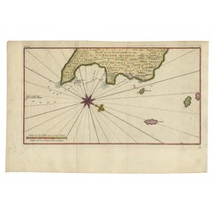
Antique print titled 'Plan de l'Isle et Ville de Quiloa, Grondtékening van 't Eiland en de Stad Quiloa'.
This bird's-eye view show the East African island of Quiloa, now known as Kilwa Kisiwani in Tanzania. The map shows the fort, settlements, and gardens of the island. It dates to a few decades before the Arab conquest of the island, after which the French built a fort at its northern end. This print originates from 'Historische beschryving der reizen, of Nieuwe en volkoome verzameling van de aller-waardigste en zeldsaamste Zee- en Landtogten' by P. de Hondt.
Artists and Engravers: Jakob van der Schley (1715-1779) was a Dutch draughtsman and engraver, who studied under Bernard Picart. Jacques-Nicolas Bellin (1703-1772) was a French hydrographer, geographer and member of The Philosophes. His career, spanning over 50 years, caused an enormous output in maps, particular of maritime interest.
Condition: Very good, please study image carefully.
- Dimensions:Height: 9.85 in (25 cm)Width: 7.68 in (19.5 cm)Depth: 0 in (0.02 mm)
- Materials and Techniques:
- Period:1740-1749
- Date of Manufacture:1749
- Condition:
- Seller Location:Langweer, NL
- Reference Number:
About the Seller
5.0
Platinum Seller
These expertly vetted sellers are 1stDibs' most experienced sellers and are rated highest by our customers.
Established in 2009
1stDibs seller since 2017
1,919 sales on 1stDibs
Typical response time: <1 hour
- ShippingRetrieving quote...Ships From: Langweer, Netherlands
- Return PolicyA return for this item may be initiated within 14 days of delivery.
More From This SellerView All
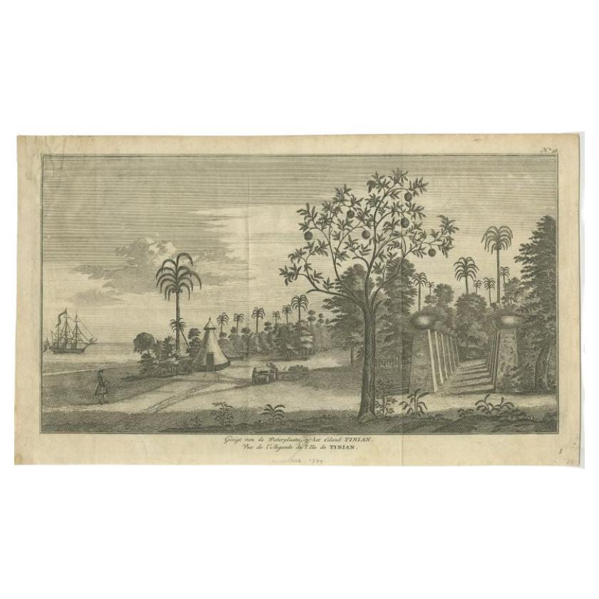
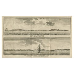
- Antique Print of Tinian Island by Anson, 1749Located in Langweer, NLAntique print titled 'Gezigt van de Waterplaats op het Eiland Tinian - Vue de l'Aiguade de l'Ile de Tinian'. View of the island Tinian in the northern Mariana Islands...Category
Antique 18th Century Prints
MaterialsPaper
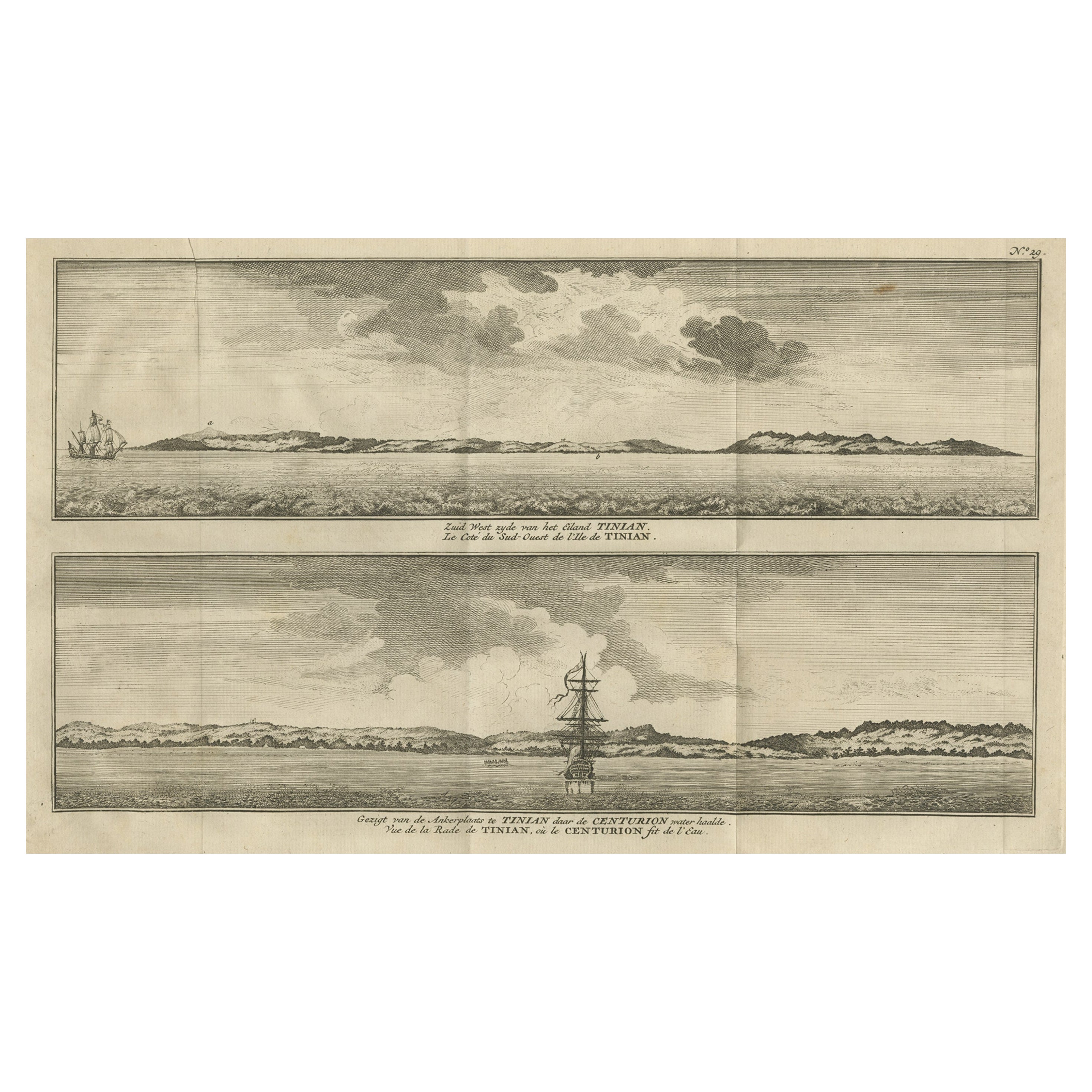
- Antique Print with Views of Tinian Island, the Northern Mariana Islands, 1749Located in Langweer, NLAntique print titled 'Le cote du sud-ouest de l'Ile de Tinian' and 'Vue de la rade de Tinian, ou le Centurion fit de l'eau.' Views of the south-west side of the island of Tinian and a view of the anchorage of Tinian, where the Centurion got water. This print originates from 'Reize rondsom de Werreld (..)' by George Anson, published 1749. Tinian is one of the three principal islands of the Commonwealth of the Northern Mariana Islands...Category
Antique 18th Century Prints
MaterialsPaper
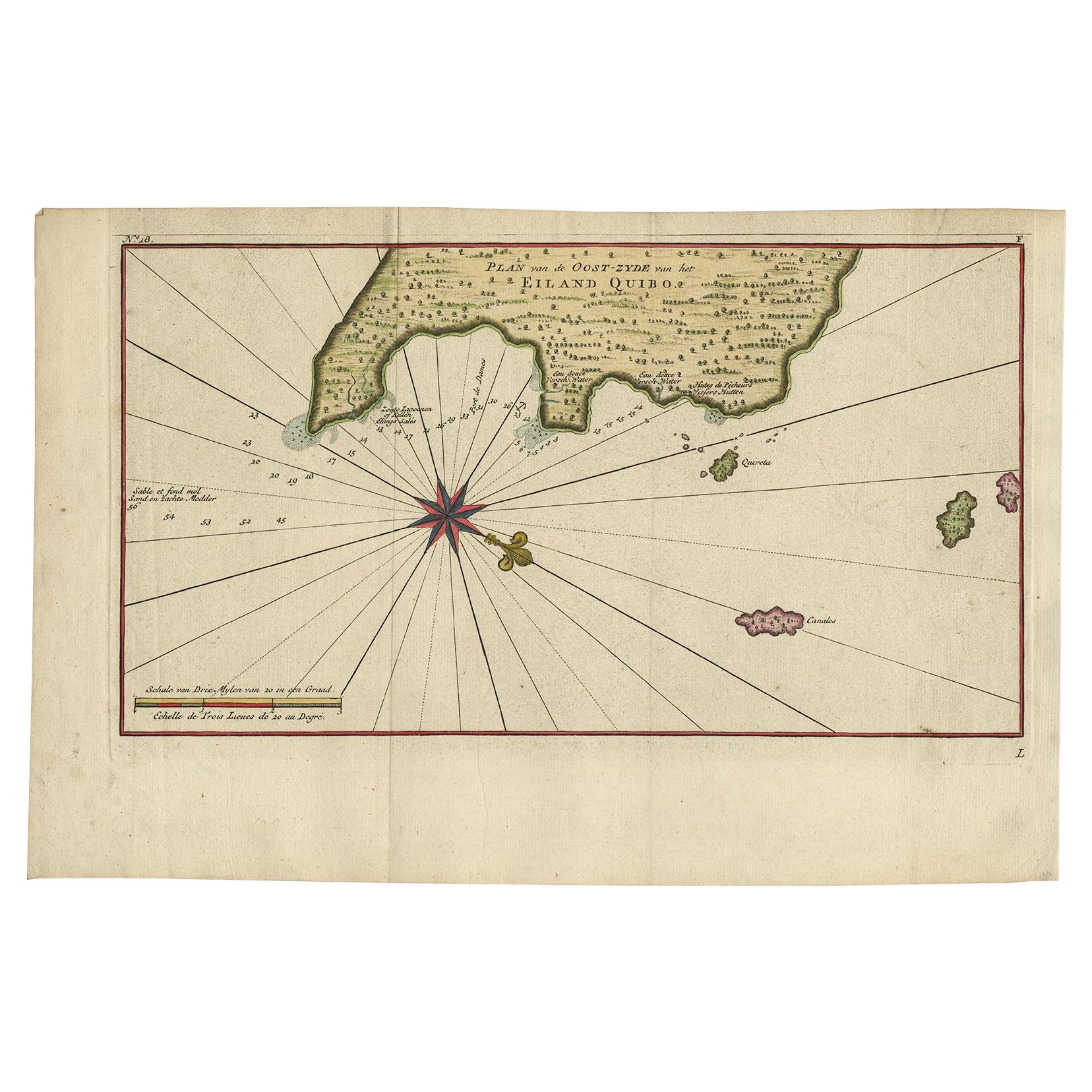
- Antique Map of Coiba Island by Anson '1749'Located in Langweer, NLAntique map titled 'Plan van de Oost-Zyde van het Eiland Quibo'. Original antique map of the eastside of Coiba Island (Quibo), Panama, showing the shoreline around Port de Dames indi...Category
Antique Mid-18th Century Maps
MaterialsPaper
- Uncoulored Original Antique Map of Western Africa, 1749Located in Langweer, NLInteresting detailed German antique map titled 'Neue Vorstellung der Abendlaendischen Küsten von Africa (..)'. Original antique map of Western Africa. This map originates from 'Neue ...Category
Antique Mid-18th Century Maps
MaterialsPaper
- Antique Map of Juan Fernandez Island by Anson '1749'Located in Langweer, NLAntique map titled 'l'Ile de Juan Fernandes dans la Mer du Sud (..) - Het Eiland Juan Fernandes in de Zuid Zee (..)'. This map depicts Juan Fernandez Island in the Southern Sea. This...Category
Antique Mid-18th Century Maps
MaterialsPaper
- Antique Map of the Eastside of Coiba Island 'Quibo', Panama, 1749Located in Langweer, NLAntique map titled 'Plan de la partie orientale de l'Isle de Quibo'. Map of the eastside of Coiba Island (Quibo), Panama, showing the shoreline around Port de Dames indicating soft s...Category
Antique 18th Century Maps
MaterialsPaper


You May Also Like
- Original Antique Map of South East Asia, Arrowsmith, 1820Located in St Annes, LancashireGreat map of South East Asia Drawn under the direction of Arrowsmith Copper-plate engraving Published by Longman, Hurst, Rees, Orme and Brown, 1820 Unframed.Category
Antique 1820s English Maps
MaterialsPaper
- Antique Large Framed Masonic or Oddfellows Decorative Lodge PrintLocated in Hamilton, OntarioThis antique print in its original frame was copyrighted by George Henry Patnoe & Henry Brown of Canada in 1909 in a Victorian style. The print depicts the symbolism of the Lodge and...Category
Early 20th Century North American Late Victorian Prints
MaterialsGesso, Paper
- Original Antique Map of South East Asia by Becker, circa 1840Located in St Annes, LancashireGreat map of South East Asia Steel engraving with original color outline Engraved by Becker Published by Virtue, circa 1840. Unframed.Category
Antique 1840s English Other Maps
MaterialsPaper
- Original Antique Map of South East Asia by Thomas Clerk, 1817Located in St Annes, LancashireGreat map of South East Asia Copper-plate engraving Drawn and engraved by Thomas Clerk, Edinburgh. Published by Mackenzie And Dent, 1817 Unframed.Category
Antique 1810s English Maps
MaterialsPaper
- Antique Cricket Print of Joseph Guy of NottinghamLocated in Oxfordshire, GBCricket print of Joseph Guy of Nottingham. A framed, tinted and hand colored lithographic portrait of the All- England cricketer Joseph Guy (1813 - 187...Category
Antique 1850s British Sporting Art Sports Equipment and Memorabilia
MaterialsPaper
- Original Antique English County Map, East Yorkshire, J & C Walker, 1851Located in St Annes, LancashireGreat map of The East Riding of Yorkshire Original colour By J & C Walker Published by Longman, Rees, Orme, Brown & Co. 1851 Unframed.Category
Antique 1850s English Other Maps
MaterialsPaper